干旱区三工河流域土壤有机碳储量及空间分布特征
- 格式:pdf
- 大小:477.60 KB
- 文档页数:8

干旱区内陆河流域土地利用结构时空变化分析1. 引言1.1 研究背景内陆河流域是世界上干旱区域最为重要的地理形态之一,其土地利用结构的变化对当地生态环境和资源开发利用具有重要的影响。
随着人口增长、经济发展和社会变迁的进程,干旱区内陆河流域的土地利用结构也面临着诸多挑战和变化。
了解内陆河流域土地利用结构的时空变化特点及规律,探讨其影响因素及城市化对其影响,对于科学合理地利用土地资源,保护生态环境,实现区域可持续发展具有重要意义。
开展干旱区内陆河流域土地利用结构时空变化分析研究,可以为制定相应的政策和措施提供科学依据,并为区域经济社会可持续发展提供借鉴和参考。
1.2 研究意义干旱区内陆河流域土地利用结构时空变化分析的研究意义主要包括以下几个方面:通过对干旱区内陆河流域土地利用结构时空变化进行分析,可以深入了解该地区土地资源的利用状况及发展趋势,为合理规划和管理土地资源提供科学依据。
研究可以帮助人们更好地认识内陆河流域土地利用结构的演变过程和原因,为保护和合理利用土地资源提供参考,有利于保持区域生态环境的平衡和稳定。
对内陆河流域土地利用结构时空变化进行分析还可以为地方政府和相关部门制定有效的发展政策和措施提供支持,促进区域可持续发展和生态环境的改善。
研究内陆河流域土地利用结构时空变化具有重要的理论和应用价值,对于推动干旱区内陆河流域土地资源合理开发利用、促进地区经济社会发展和生态环境保护具有重要意义。
1.3 研究目的为了深入了解干旱区内陆河流域土地利用结构的时空变化情况,本研究旨在通过对土地利用结构变化进行分析,探讨时空变化的趋势,并分析影响土地利用结构变化的因素。
本研究还将重点研究城市化对土地利用结构的影响,并探讨生态环境对土地利用结构的效应。
通过对以上内容的研究,旨在揭示干旱区内陆河流域土地利用结构变化的特点,总结时空变化的规律,并提出相应的发展对策建议,为该地区的土地利用规划和生态保护提供科学依据。

天山北坡三工河流域中山带森林发育与气候土壤的关系李艳忠;罗格平;许文强;尹昌应;韩其飞;冯异星【摘要】It has important theoretical significance to the cause of arid region even the world forest belt to carry out the forest development characteristic and their relationship with climatic and soil facors in aird area. The forest distribution patterns development charateristic were confirmed by field survey and Remote Sense in Sangong River watershed, and the analysis of climate and soil factors on the forest development was carried out combining meteorological and soil data. The result shows that: (1) The forest belt was 1 510 m to 2 720 m, both the DBH and tree height showed a bimodal pattern along altitude. The two peaks of DBH were located at about 2 000 m and 2 550 m respectively, while the peaks of tree height at 2 100 m and 2 600 m, little higher than the DBH ( diameter at breast height). (2)the annual temperature in the forest belt showed linearity decline along the altitude increased, while the annual precipitation showed increase first then decline, and came to the climax at 2 150 m. Compared to other forest area, the alpine timberline in Sangong river watershed was higher, little difference in mean temperature for the warmest month. The soil characteristic took on regular change along the altitude increase. The forest developed better between 2 000 to 2 700 m, which organic matter, total phosphorus and total nitrogen than other altitudes. The minimum of CaCO3, pH value and the electrical conductivity just located at the the maximum precipitation belt. The content of soilorganic matter, total phosphorus and total nitrogen at layer A(0 -10 cra)were significant differences of layer B( 10- 30 cm) and layer C( > 30 cm) ,which revealed that the soil nutrients have significant surface convergence phenomenon and the soil-forming conditions act on the shallow layer. The CaCO3, pH value and the electrical conductivity took no significant differences between each layer. (3)The environmental factors controlling the forest distribution pattern and its pattern were the combined effects of altitude, precipitation, temperature and soil nutrition. Comparing the change of DBH to environmental factors along altitude and correlating them by variance analysis revealed that soil nutrition was the key factor of controlling growth and development of Picea schrenkiana,and the ecology factor status were soil nutrition >precipitation > altitude > temperature.%开展干旱区山地森林发育状况及其土壤因素影响的分析,对干旱区乃至全球山地森林带的成因研究具有重要的理论意义.以天山北坡三工河流域为研究区,主要利用森林调杳与遥感影像数据,确定该流域森林带的分布状况,并结合流域气象与土壤采样数据,莺点分析气候土壤因素对森林发育的影响.结果表明:1.该流域森林带位于海拔1 510~2 720 m,胸径与树高随海拔增加呈双峰曲线;其中胸径两个峰值分别位于约海拔2 000 m与2 550m,而树高峰值分别为海拔2 100 m与2 600 m,均稍高于胸径的峰值海拔高度;2.在森林带内,年均温随海拔高度增加旱线性下降趋势,最冷月均温(1月)则表现先增加后减小趋势;与其他地区相比,该流域高山林线年均温较高,最冷月均温棚筹较大,而最热月均温差异不明显;年降水量呈先增加后减小的趋势,且在海拔2 000 m左右达到最大值.土壤属性随海拔递增呈规律性的变化趋势:森林带内海拔约2 000~2 700 m树木发育较好,其有机质、全磷及令氮含量较高;CaCO3,pH值及电导率最小值与海拔2000 m的最大降水带恰好吻合;土壤A层(0~10 cm)有机质、全磷及全氮含量与B(10~30 cm)、C(>30 cm)层差异显著,表明营养物质"表聚现象"明显,成土条件作用于土壤的深度较浅,而CaCO3,pH值与电导率各层间差异不显著.3.森林带分布格局是山降水、温度、海拔以及土壤营养等因索综合控制,方筹分析表明土壤理化性质为限制森林带内雪岭云杉生长发育的主导凶子,各生态因子对森林发育影响的作用地化为:土壤营养>降水>海拔>温度.【期刊名称】《山地学报》【年(卷),期】2011(029)001【总页数】10页(P33-42)【关键词】天山北坡;三工河流域;气候条件;土壤属性;高山林线【作者】李艳忠;罗格平;许文强;尹昌应;韩其飞;冯异星【作者单位】中国科学院新疆生态与地理研究所,新疆乌鲁木齐830011;中国科学院研究生院,北京100039;中国科学院新疆生态与地理研究所,新疆乌鲁木齐830011;中国科学院新疆生态与地理研究所,新疆乌鲁木齐830011;中国科学院新疆生态与地理研究所,新疆乌鲁木齐830011;中国科学院研究生院,北京100039;中国科学院新疆生态与地理研究所,新疆乌鲁木齐830011;中国科学院研究生院,北京100039;中国科学院新疆生态与地理研究所,新疆乌鲁木齐830011;中国科学院研究生院,北京100039【正文语种】中文【中图分类】Q142;Q948;S718.5森林作为陆地生态系统的重要组成部分,对改善生态环境、维护生态平衡具有不可替代的作用[1],特别是干旱区森林生态系统对生态环境的建设具有重要作用[2]。

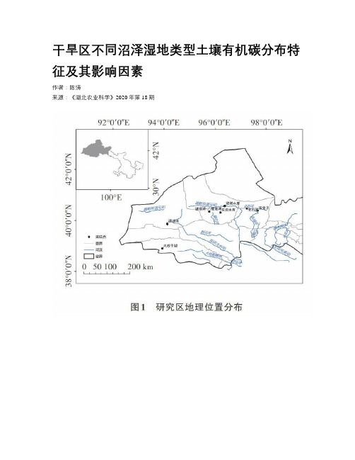
干旱区不同沼泽湿地类型土壤有机碳分布特征及其影响因素作者:陈涛来源:《湖北农业科学》2020年第18期摘要:以干旱区湿地为研究对象,对草本沼泽、季节性咸水沼泽和内陆盐沼3种类型湿地的土壤有机碳分布特征及其影响因素进行了研究。
结果表明,草本沼泽、季节性咸水沼泽以及内陆盐沼0~100 cm土层的土壤有机碳含量分别为1.19~49.03、1.62~101.14、2.61~23.77g/kg,其中,季节性咸水沼泽有机碳含量显著高于草本沼泽;草本沼泽土壤有机碳含量与土壤水分、全氮、N/P呈顯著正相关,季节性咸水沼泽湿地土壤有机碳含量与土壤水分、容重、全氮和N/P均呈显著正相关,与pH呈极显著负相关,内陆盐沼土壤有机碳含量与全氮呈极显著正相关。
结合主成分分析,3种湿地类型主成分F1贡献率最高,且与土壤水分高度相关。
证明土壤水分是影响土壤有机碳积累的关键主导因素。
关键词:干旱区湿地;土壤有机碳;分布特征;土壤水分;沼泽湿地中图分类号:S153.6 文献标识码:A文章编号:0439-8114(2020)18-0054-09DOI:10.14088/ki.issn0439-8114.2020.18.011 开放科学(资源服务)标识码(OSID):Distribution characteristics of soil organic carbon and its influencing factorsin different swamp wetland types in arid regionCHEN Tao(College of Geography and Environmental Science, Northwest Normal University, Lanzhou 730070, China)Abstract: Taking wetlands in arid areas as the research object, the distribution characteristics and influencing factors of soil organic carbon in three types of wetlands: Herb marshes, seasonal salt-water marshes and inland salt marshes were studied. The results showed that the soil organic carbon content of the 0~100 cm soil layer of herbaceous marsh, seasonal saltwater marsh and inland salt marsh were 1.19~49.03, 1.62~101.14, 2.61~23.77 g/kg, respectively. The organic carbon content of seasonal saltwater marshes was significantly higher than that of herbaceous marshes; The soil organic carbon content of herbaceous marshes was significantly positively correlated with soil moisture, total nitrogen, and N/P. Seasonal saltwater the soil organic carbon of marsh wetlands was significantly correlated with soil moisture, bulk density, total nitrogen and N/P,and pH showed a very significant negative correlation. Inland salt marsh soil organic carbon was significantly correlated with total nitrogen was extremely significant positive correlation. Combined with the principal component analysis, three types of wetland F1 contribution rate was highly correlated with soil moisture. It was proved that soil moisture was the key leading factor affecting the accumulation of soil organic carbon.Key words: arid wetland; soil organic carbon; distribution characteristics; soil moisture; marsh wetland湿地是陆地生态系统的重要组成部分,尽管其面积仅占地球陆地面积的3%,但是有机碳储量却达到了陆地生态系统总量的30%,相当于100年矿石燃料的CO2释放量[1]。

天山北坡土壤有机碳δ13 C组成随海拔梯度的变化许文强;罗格平;陈曦;冯异星;李超凡【摘要】本文选择天山北坡三工河流域作为研究区,基于碳稳定同位素技术,分析土壤有机碳(SOC )δ13 C值随降雨量的变化,研究不同海拔梯度土壤剖面δ13 C值随采样深度的变化。
结果显示,三工河流域降雨量在300 mm以下的采样点,SOC δ13 C 值随降雨量的增加呈递减趋势(R2=0.97),而降雨量在300 mm~500 mm的采样点,δ13C值随降雨量变化不明显(R2=0.04);三工河流域纯C3植物采样点土壤剖面δ13 C值随采样深度呈现明显的富集效应,即土壤剖面下层δ13 C值大于上层,其平均差值为1.01‰,与其他相关区域研究结果一致;而沙质荒漠和土质荒漠采样点剖面下层与上层SOC δ13 C平均差值为4.33‰,其变化趋势与纯C3植物采样点相反,且其表层δ13 C值接近C4植物来源,底层接近C3植物来源,推断其地上历史植被可能经历了由C3到C4的演替过程。
%Soil organic carbon (SOC) pool integrated the vegetation succession informa‐tion from several years to thousands of years scales .It is an ideal tool to understand carbon isotope composition change and terrestrial ecosystem pathways .In this study , the Sangong river watershed was tak en as a case .We had estimated the change of vege‐tation and soil organic along a vertical gradient using the carbon isotopic method ,and analyzed the variations of mean SOC δ13 C values with the annual precipitation , and researched the variations in SOC and δ13 C values with profile depth in the study area . n<br> The results showed that the SOC δ13C decreased significantly with the increasing annual precipitation (R2 =0.97) where the annual precipitation was less than 300 mm .When theannual precipitatio n was 300 mm ~ 500 mm , the SOC δ13 C was not significant changed with the increasing annual precipitation (R2=0.04) .The enrichment effect of SOC δ13 C with depth was significant in the sample site of pure C3 vegetation , that means lower layer SOC δ13 Cof profile was greater than the upper layer .The average difference of SOC δ13 C between lower layer and upper layer was 1.01‰ .The opposite trend of SOC δ13 C was presented in the Desert and Shrubland sites .Andthat ,the SOCδ13 C value of upper layer cl osed to C4 vegetationsource ,and the lower layer closed to C3 vegetation source .Therefore ,we can infer that the vegetation may have experienced from C3 to C4 in the sandy desert and terrene desert sites .【期刊名称】《同位素》【年(卷),期】2016(029)003【总页数】6页(P140-145)【关键词】碳同位素;δ13C值;C3和C4植物;δ13C富集效应;三工河流域【作者】许文强;罗格平;陈曦;冯异星;李超凡【作者单位】中国科学院新疆生态与地理研究所,荒漠与绿洲生态国家重点实验室,新疆乌鲁木齐 830011;中国科学院新疆生态与地理研究所,荒漠与绿洲生态国家重点实验室,新疆乌鲁木齐 830011;中国科学院新疆生态与地理研究所,荒漠与绿洲生态国家重点实验室,新疆乌鲁木齐830011;贵州省黔南州国土资源储备局,贵州都匀 558000;中国科学院南京土壤研究所,江苏南京 210008【正文语种】中文【中图分类】S153;TL99土壤有机碳(SOC)的同位素组成取决于其地表植被特征和气候状况,而SOC库综合了数年到数万年植被的演替信息,是对区域生物量碳同位素组成变化的最佳记录[1-3]。
干旱区内陆河流域土地利用结构时空变化分析一、引言干旱区内陆河流域是干旱半干旱地区的重要生态系统之一,土地利用结构和时空变化对于区域的生态环境、资源利用和经济发展具有重要影响。
对干旱区内陆河流域土地利用结构的时空变化进行深入研究,对于合理利用土地资源、保护生态环境具有重要的意义。
二、干旱区内陆河流域土地利用结构时空变化的特点1. 气候条件影响干旱区内陆河流域的土地利用结构时空变化受气候条件的影响较大。
气候条件的变化导致了土地的适宜性发生变化,影响了土地资源的开发利用。
2. 人类活动影响人类的活动对于干旱区内陆河流域的土地利用结构时空变化具有重要的影响。
农业、畜牧业、工业和城市建设等活动的不断推进,导致了土地利用结构和时空分布的变化。
3. 土地资源利用的矛盾干旱区内陆河流域土地资源的特点是稀缺和不均匀分布,土地资源开发利用的矛盾日益凸显,这直接影响了土地利用结构的时空变化。
三、时空变化分析方法1. 遥感技术遥感技术是研究干旱区内陆河流域土地利用结构时空变化的重要手段之一。
通过遥感图像的获取和处理,可以对土地利用结构的时空分布进行快速准确的分析。
2. 地理信息系统(GIS)地理信息系统是对土地利用结构时空变化进行分析的重要工具。
可以通过GIS对各时期的土地利用数据进行整合和分析,分析其时空变化的规律和趋势。
四、干旱区内陆河流域土地利用结构时空变化的影响1. 生态环境影响土地利用结构的时空变化对生态环境具有重要影响。
不合理的土地利用结构会导致生态环境退化、水土流失等问题,对区域的生态环境产生负面影响。
2. 资源利用影响土地利用结构的时空变化直接影响土地资源的开发利用。
不合理的土地利用结构会导致土地资源的浪费和过度开发,影响资源的可持续利用。
五、干旱区内陆河流域土地利用结构时空变化的对策1. 加强规划管理加强对干旱区内陆河流域土地利用的规划管理,制定合理的土地利用政策,划定合理的土地利用结构和时空布局,促进土地资源的合理利用。
新疆三工河流域山地、平原区气候变化特征对比分析杨余辉;魏文寿;杨青;崔宇;马玉香【期刊名称】《干旱区地理》【年(卷),期】2005(28)3【摘要】通过分析三工河流域近40a气候变化特征,结果表明:(1)近40年三工河流域平原区平均温度以0.27℃/10a趋势上升,和全疆变化一致,低于北疆地区;流域山区增温趋势较慢,平均每10年以0.14℃的趋势增温,但冬季增温显著,暖冬趋势明显。
(2)三工河流域平原区1987-2000年比1961-1986年平均降水量偏多35%;三工河流域山区,20世纪80年代降水增加较显著,90年代降水量减少到70年代水平。
(3)三工河流域平原区和山区气温、降水,同一气象要素呈现正相关;三工河流域平原区温度与降水没有明显相关性;山区温度与降水表现出负相关性。
(4)三工河流域山区温度和降水用Mann-kendall方法检验没有达到突变水平,工河流域平原区降水,用Mann-kendall方法检验在1984年发生了由低向高的突变,温度在1995年发生了由低向高的突变。
近36a三工河流域平原区干旱指数下降趋势显著,用Mann-kendall方法检验在1983年发生了由高向低的突变;山区干旱指数下降较慢。
【总页数】5页(P320-324)【关键词】三工河流域;气候变化;气候突变;干旱指数;新疆【作者】杨余辉;魏文寿;杨青;崔宇;马玉香【作者单位】新疆师范大学生命与环境科学学院;中国气象局乌鲁木齐沙漠气象研究所【正文语种】中文【中图分类】P467【相关文献】1.新疆三工河流域平原区潜水蒸发特征分析 [J], 刘芳;魏守忠2.新疆三工河流域冲洪积平原区潜水蒸发特征与潜水调控 [J], 孙宝林;魏守忠;马健;杨瑾;刘绿林3.塔里木河干流平原区气候变化趋势及特征分析 [J], 宋蕊[1];洪辉[2]4.近50年来新疆阿克苏河流域平原区气候变化周期分析研究 [J], 刘锋;严冬;范文晓;马亮;魏光辉5.三工河流域平原区蒸发量变化特征及影响因素 [J], 陈伏龙;冯平;吴泽斌因版权原因,仅展示原文概要,查看原文内容请购买。