激光测距外文翻译
- 格式:doc
- 大小:103.00 KB
- 文档页数:11

laser 测量原理
激光测距(laser distance measuring)是以激光器作为光源进行测距。
根据激光工作的方式,可以分为连续激光器和脉冲激光器。
激光测距的原理主要是基于光速和时间的关系,通过测量光在空气中传播的时间来计算距离。
对于脉冲激光测距,测距仪发射出的激光经被测量物体的反射后又被测距仪接收,测距仪同时记录激光往返的时间。
光速和往返时间的乘积的一半,就是测距仪和被测量物体之间的距离。
脉冲法测量距离的精度一般是在±10厘米左右,而测量盲区一般是1米左右。
此外,还有相位式激光测距,主要使用连续输出的氦氖、氩离子、氪镉等气体激光器。
相位式激光测距的原理是利用激光器的频率稳定度和传播速度,通过测量相位差来计算距离。
相位式激光测距的精度较高,可以达到毫米级别,但测量范围较小。
以上内容仅供参考,如需获取更多信息,建议查阅关于激光测距的资料或者咨询专业人士。

Table of ContentsUuit 1 What is Geomatics? (什么是测绘学) 2Unit 2 Geodetic Surveying and Plane Surveying(大地测量与平面测量) 6Unit 3 Distance Measurement(距离测量) 10Unit 4 Angle and Direction Measurement(角度和方向测量) 14Unit 5 Traversing (导线测量) 18Unit 6 Methods of Elevation Determination(高程测量方法) 22Unit 7 Robotic Total Station (智能型全站仪) 26Unit 8 Errors in Measurement(测量工作中的误差) 30Unit 9 Basic Statistical Analysis of Random Errors 34Unit 10 Accuracy and Precision (准确度和精度) 37Unit 11 Least-Squares Adjustment 40Unit 12 Geodesy Concepts 42Unit 13 Geoid and Reference Ellipsoid 44Unit 14 Datums, Coordinates and Conversions 46Unit 15 Map Projection 48Unit 16 Gravity Measurment 51Unit 17 Optimal Design of Geomatics Network 53Unit 18 Construction Layout (施工放样) 56Unit 19 Deformation Monitoring of Engineering Struvture 59Unit 20 Understan ding the GPS(认识 GPS) 62Uuit 21 Understanding the GPS (II) 认识 GPS(II) 65Unit 22 Competition in Space Orbit(太空轨道上的竞争) 68Unit 23 GIS Basics(GIS 的基础) 73Unit 24 Data Types and Models in GIS GIS中的数据类型和模型 79 Unit 25 Digital Terrain Modeling(数字地面模型) 83Unit 26 Applications of GIS 88Unit 27 Developments of photogrammetry 92Unit 28 Fundamentals of Remote Sensing (遥感的基础) 95Unit 29 Digital Image Processing and Its Applications in RS 99Unit 30 Airborne Laser Mapping Technology(机载激光测图技术) 104Unit 31 Interferometric SAR(InSAR) 108Unit 32 Brief Introduction toApplied Geophysics 110Unit 33 Origon of Induced Polarization 112Unit 34 International Geoscience Organization 115Unit 35 Prestigious Journals in Geomatics 118Unit 36 Relevant Surveying Instrument Companies 123Unit 37 Expression of Simple Equations and ScientificFormulsa 124Unit 38 Professional English Paper Writing 128Unit 39 Translation Techniques for EST 136Uuit 1 What is Geomatics? (什么是测绘学)Geomatics Defined(测绘学定义)Where does the word Geomatics come from?(Geomatics-测绘或地球空间信息学,这个名词是怎么来的呢?) GEODESY+GEOINFORMATICS=GEOMATICS or GEO- for earth and – MATICS for mathematical or GEO- for Geoscience and -MATICS for informatics. (大地测量学+地理信息学=GEOMATICS 测绘学或者geo 代表地球,matics 代表数学,或者 geo 代表地球科学,matics 代表信息学) It has been said that geomatics is many things to many people.(据说测绘学这个词对不同的人有不同的理解) The term geomatics emerged first in Canada and as an academic discipline; it has been introduced worldwide in a number of institutes of higher education during the past few years, mostly by renaming what was previously called “geodesy” or“surveying”, and by adding a number of computer scienceand/or GIS-oriented courses.(这个术语【term 术语】作为一个学科【academicdiscipline 学科】第一次形成【emerge】于加拿大;在过去的几年里被全世界的许多高等教育研究机构所熟知,通常是以前的“大地测量学” 或“测量学”在引入了许多计算机科学和 GIS 方向【或“基于GIS”】的课程后重新命名的。

塔尔科特测纬度法 talcott method of latitude determination台链 station chain太阳辐射波谱 solar radiation spectrum太阳光压摄动 solar radiation pressure perturbation太阳同步卫星 sun-synchronous satellite态势地图 posture map特殊水深 special depth特征 feature特征编码 feature coding特征码 feature codes特征码清单 feature codes menu特征提取 feature extraction特征选择 feature selection特种地图 particular map体素 voxel天波干扰 sky-wave interference天波修正 sky-wave correction天顶距 zenith angle天顶距 zenith distance天球坐标系 celestial coordinate system天球坐标系 celestial coordinate system天文大地垂线偏差 astro-geodetic deflection of the vertical 天文大地网 astro-geodetic network天文大地网平差 adjustment of astrogeodetic network天文点 astronomical point天文定位系统 astronomical positioning system天文方位角 astronomical azimuth天文经度 astronomical longitude天文经纬仪 astronomical theodolite天文年历 astronomical almanac天文年历 astronomical ephemeris天文水准 astronomical leveling天文纬度 astronomical latitude天文重力水准 astro-gravimetric leveling天文坐标测量仪astronomical coordinate measuring instrument天线高度 antenna height田谐系数 coefficient of tesseral harmonics田谐系数 coefficient of tesseral harmonics条幅[航带]摄影机 continuous strip camera条幅[航带]摄影机 continuous strip camera条幅[航带]摄影机 strip camera条件方程 condition equation条件方程 condition equation条件平差 condition adjustment条件平差 condition adjustment铁路工程测量 railroad engineering survey通用横墨尔卡投影 universal transverse mercator projection通用极球面投影 universal polar stereographic projection通用极球面投影 ups通用墨卡尔投影 utm同步观测 simultaneous observation同步验潮 tidal synobservation同名光线 corresponding image rays同名光线 corresponding image rays同名核线 corresponding epipolar line同名核线 corresponding epipolar line同名像点 corresponding image points同名像点 corresponding image points同名像点 homologous image points统计地图 statistic map投影变换 projection transformation投影差 height displacement投影差 relied displacement投影方程 projection equation投影器 projector投影器主距 principal distance of projector投影晒印 projection printing透光率 transmittance透明负片 transparent negative透明正片 transparent positive透明注记 stick-up lettering透视截面法 perspective traces透视投影 perspective projection透视旋转定律,*沙尔定律 chasles theorem透视旋转定律,*沙尔定律 chasles theorem透视旋转定律,*沙尔定律 rotation axiom of the perspective 透视旋转定律,*沙尔定律 rotational theorem图幅 mapsheet图幅编号 sheet designation图幅编号 sheet number图幅接边 edge matching图幅接合表 index diagram图幅接合表 sheet index图根点 mapping control point图根控制 mapping control图解纠正 graphical rectification图解图根点 graphic mapping control point图廓 edge of the format图廓 map border图历簿 mapping recorded file图例 legend图面配置 map layout图象 picture图像编码 image coding图像变换 image transformation图像处理 image processing图像分割 image segmentation图像分析 image analysis图像复合 image overlaying图像几何纠正 geometric rectification of imagery 图像几何配准 geometric registration of imagery 图像理解 image understanding图像描述 image description图像识别 image recognition图像数字化 image digitization图像增强 image enhancement图形 graphics图形-背景辨别 f-g discrimination图形-背景辨别 figure-ground discrimination图形符号 graphic symbol图形记号 graphic sign图形权倒数 weight reciprocal figure图形元素 graphic elements土地规划测量 land planning survey土地利用现状图 present landuse map土地信息系统 land information system土地信息系统 lis推荐航线 recommended route托帕可斯卫星 t/p托帕克斯卫星 topex/poseidon拖底扫海 aground sweeping陀螺定向光电测距导线 gyrophic edm traverse陀螺方位角 gyro azimuth陀螺经纬仪 gyro theodolite陀螺经纬仪 gyroscopic theodolite陀螺仪定向测量 gyrostatic orientation survey椭球扁率 flattening of ellipsoid椭球长半轴,*地球长半轴 semimajor axis of ellipsoid 椭球短半轴,*地球短半轴 semiminor axis of ellipsoid 椭球面大地测量学 ellipsoidal geodesy椭球偏心率 eccentricity of ellipsoid拓扑地图 topological map拓扑关系 topological relation拓扑检索 topological retrieval外部定向 exterior orientation网点 stipple网格地图 grid map网格法 grid method网格结构 grid structure网屏 screen网纹片 transparent foil网线 ruling危险界限 limiting danger line微波测距仪 microwave distance measuring instrument 微波辐射 microwave radiation微波辐射计 microwave radiometer微波图像 microwave imagery微波遥感 microwave remote sensing微波遥感器 microwave remote sensor微重力测量 microgravimetry维纳频谱 winer spectrum维宁?曼尼斯公式 vening-meinesz formula伪彩色图像 pseudo-color image伪等值线地图 pseudo-isoline map伪距测量 pseudo-range measurement卫星测高 satellite altimetry卫星大地测量 satellite geodesy卫星定位 satellite positioning卫星多普勒[频移]测量 satellite doppler shift measurement卫星多普勒定位 satellite doppler positioning卫星高度 satellite altitude卫星跟踪卫星技术 satellite-to-satellite tracking卫星跟踪卫星技术 sst卫星跟踪站 satellite tracking station卫星共振分析 analysis of satellite resonance卫星构形 satellite configuration卫星-惯导组合定位系统satellite-inertial guidance integrated positioning sy卫星轨道改进 improvement of satellite orbit卫星激光测距 satellite laser ranging卫星激光测距,侧视雷达 slr卫星激光测距仪 satellite laser ranger卫星-声学组合定位系统satellite-acoustics integrated positioning system卫星受摄运动 perturbed motion of satellite卫星像片图 satellite photo map卫星星下点 sub-satellite point卫星运动方程 equation of satellite motion卫星重力梯度测量 satellite gradiometry卫星姿态 satellite attitude位置[线交]角 intersection angle of lop位置函数,*坐标函数 position function位置精度 positional accuracy位置线 line of position位置线 lop位置线方程 equation of lop文化地图 cultural map文化地图 cultural map纹理分析 texture analysis纹理增强 texture enhancement沃尔什变换 walsh transformation无线电定位 radio positioning无线电航行警告 radio navigational warning无线电指向标,*电指向 radio beacon无线电指向标表 list of radio beacon五角棱镜 pentaprism物镜分辨力 resolving power of lens物理大地测量学,*大地重力学 physical geodesy 误差检验 error test误差理论 theory of errors误差椭圆 error ellipse雾[信]号 fog signal系列地图 series maps系统集成 system integration系统误差 systematic error弦线支距法 chord off-set method弦线支距法 chord off-set method显微摄影 photomicrography现势地图 up-to-data map线路平面图 route plan线路水准测量 route leveling线路中线测量 center line survey线路中线测量 center line survey线路中线测量 location of route线纹米尺,*日内瓦尺 standard meter线形锁 linear triangulation chain线形网 linear triangulation network线性调频脉冲 chirp线性调频脉冲 chirp线阵遥感器 linear array sensor线阵遥感器 pushbroom sensor线状符号 line symbol限差 tolerance限航区 restricted area乡村规划测量 rural planning survey相对定位 relative positioning相对定向 relative orientation相对定向元素 element of relative orientation相对航高 relative flying height相对论改正 relativistic correction相对误差 relative error相对重力测量 relative gravity measurement相干声呐测深系统 interferometric seabed inspection sonar 相关平差 adjustment of correlated observation相关器 correlator相关器 correlator相位传递函数 phase transfer function相位传递函数 ptf相位多值性 phase ambiguity相位模糊度解算 phase ambiguity resolution相位漂移 phase drift相位稳定性 phase stability相位周,*巷 lane相位周,*巷 phase cycle相位周值,*巷宽 lane width相位周值,*巷宽 phase cycle value镶嵌索引图 index mosaic巷道验收测量 footage measurement of workings象限仪 quadrant象形符号 replicative symbol像场角 angular field of view像等角点 isocenter of photograph像底点 photo nadir point像地平线,*合线 horizon trace像地平线,*合线 image horizon像地平线,*合线 vanishing line像幅 picture format像空间坐标系 image space coordinate system像片 photo像片 photograph像片比例尺 photo scale像片地质判读,*像片地质解译geological interpretation of photograph像片方位角 azimuth of photograph像片方位元素 photo orientation elements像片基线 photo base像片纠正 photo rectification像片内方位元素 elements of interior orientation像片判读 photo interpretation像片平面图 photoplan像片倾角 tilt angle of photograph像片外方位元素 elements of exterior orientation 像片镶嵌 photo mosaic像片旋角 swing angle像片旋角 yaw像片主距 principal distance of photo像平面坐标系 photo coordinate system像移补偿 image motion compensation像移补偿 imc像元 pixel像主点 principal point of photograph像主纵线 principal line [of photograph]销钉定位法 stud registration小潮升 neap rise小潮升 neap rise小角度法 minor angle method小像幅航空摄影 sfap小像幅航空摄影 small format aerial photography 协调世界时 coordinate universal time协调世界时 coordinate universal time协调世界时 utc协调世界时时号 time signal in utc协方差函数 covariance function协方差函数 covariance function心象地图 mental map新版海图 new edition of chart新版海图 new edition of chart信号杆 signal pole信息量 contents of information信息量 contents of information信息提取 information extraction信息属性 information attribute星载遥感器 satellite-borne sensor行差 run error行星大地测量学 planetary geodesy行政区划图 administrative map修版 retouching虚地图 virtual map虚拟地景 virtual landscape序惯平差 sequential adjustment悬式经纬仪 hanging theodolite旋转参数 rotation parameters选取限额 norm for selection选取限额 norm for selection选取指标 index for selection选权迭代法 iteration method with variable weights寻北器 north-finding instrument寻北器 north-finding instrument寻北器 polar finder压力验潮仪 pressure gauge亚太区域地理信息系统基础设施常设委员会 pcgiap亚太区域地理信息系统基础设施常设委员会permanent committee on gis infrastructure for asia and the pacific 严密平差 rigorous adjustment沿海测量 coastwise survey沿海测量 coastwise survey颜色空间 color space颜色空间 color space验潮 tidal observation验潮仪 tide-meter验潮站 tidal station验潮站零点 zero point of the tidal阳像 positive image遥感 remote sensing遥感测深 remote sensing sounding遥感模式识别 pattern recognition of remote sensing 遥感平台 remote sensing platform遥感数据获取 remote sensing data acquisition遥感制图 remote sensing mapping野外地质图 field geological map野外填图 field mapping因瓦基线尺 invar baseline wire阴像 negative image阴像 negative image引潮力 tide-generating force引潮位 tide-generating potential引航图集 pilot atlas引力 gravitation引力位 gravitational potential引水锚地 pilot anchorage引张线法 method of tension wire alignment印刷版 printing plate荧光地图 fluorescent map影像 image影像 imagery影像地质图 geological photomap影像分辨力 image resolution影像分辨力 resolving power of image影像复原 image restoration影像金字塔 image pyramid影像匹配 image matching影像融合 image fusion影像数据库 image database影像相关 image correlation影像镶嵌 image mosaic影像质量 image quality游艇用图 smallcraft chart游艇用图 yacht chart渔礁 fishing rock渔堰 fishing haven渔业用图 fishing chart渔栅 fishing stake宇宙制图 cosmic mapping宇宙制图 cosmic mapping预报地图 prognostic map预打样图 pre-press proof预制符号 preprinted symbol预制感光板,*ps 版 presensitized plate原子钟 atomic clock圆曲线测设 circular curve location圆曲线测设 circular curve location圆-圆定位,*距离-距离定位 range-range positioning 圆柱投影 cylindrical projection圆柱投影 cylindrical projection圆锥投影 conic projection圆锥投影 conic projection远程定位系统 long-range positioning system远海测量 pelagic survey月平均海面 monthly mean sea level月球轨道飞行器 lunar orbiter运动方程分析解 analytical solution of motion equation 运动方程数值解 numerical solution of motion equation 运动方程数值解 numerical solution of motion equation 运动线法 arrowhead method晕滃法 hachuring晕渲法 hill shading载波相位测量 carrier phase measurement载波相位测量 carrier phase measurement再分结构 subdivisional organization凿井施工测量 construction survey for shaft sinking凿井施工测量 construction survey for shaft sinking栅格绘图 raster plotting栅格数据 raster data站心坐标系 topocentric coordinate system章动 nutation章动 nutation照相排字机 phototypesetter照相制版镜头 printer lens照相制版镜头 process lens照准点 sighting point照准点归心 sighting centring真地平线,*真水平线 true horizon真实孔径雷达 real-aperture radar真误差 true error真子午线 true meridian整体大地测量 integrated geodesy整体感 associative perception整体结构 extensional organization正常高 normal height正常高 normal height正常水椭球,*水准椭球 normal level ellipsoid 正常水椭球,*水准椭球 normal level ellipsoid 正常引力位 normal gravitation potential正常引力位 normal gravitation potential正常重力 normal gravity正常重力 normal gravity正常重力场 normal gravity field正常重力场 normal gravity field正常重力公式 normal gravity formula正常重力公式 normal gravity formula正常重力位 normal gravity potential正常重力位 normal gravity potential正常重力线 normal gravity line正常重力线 normal gravity line正方形分幅 square mapsubdivision正片 positive正象 right-reading正直摄影 normal case photography正直摄影 normal case photography正轴投影 normal projection正轴投影 normal projection郑和航海图 zheng he's nautical chart政治地图 political map支水准路线 spur leveling line直方图规格化 histogram specification直方图均衡 histogram equalization直角坐标网 rectangular grid志田数 shida'a number制图分级 cartographic hierarchy制图分级 cartographic hierarchy制图简化 cartographic simplification制图简化 cartographic simplification制图精度 mapping accuracy制图夸大 cartographic exaggeration制图夸大 cartographic exaggeration制图专家系统 cartographic expert system制图专家系统 cartographic expert system制图资料 cartographic document制图资料 cartographic document制图资料 source material质底法 quality base method质量感 qualitative perception秩亏平差 rank defect adjustment置信度 confidence置信度 confidence中程定位系统 medium-range positioning system中国测绘学会chinese society of geodesy, photogrammetry and cartog中国测绘学会 csgpc中国测绘学会chinese society of geodesy, photogrammetry and cartog中国测绘学会 csgpc中国大地测量星表 cgsc中国大地测量星表 chinese geodetic stars catalogue中国大地测量星表 cgsc中国大地测量星表 chinese geodetic stars catalogue中华人民共和国测绘法surveying and mapping law of the people's republic of中天法 transit method中误差 rmse中误差 root mean square error中心式快门 between-the-lens shutter中心式快门 lens shutter中星仪 transit instrument中性色调,*灰色调 middle tone中央子午线 central meridian中央子午线 central meridian钟偏 clock offset钟偏 clock offset钟速 clock rate钟速 clock rate重采样 resampling重力 gravity重力测量 gravity measurement重力场 gravity field重力潮汐改正 correction of gravity measurement for tide 重力潮汐改正 correction of gravity measurement for tide 重力垂线偏差 gravimetric deflection of the vertical重力垂直梯度 vertical gradient of gravity重力点 gravimetric point重力固体潮观测 gravity observation of earth tide重力归算 gravity reduction重力基线 gravimetric baseline重力基准 gravity datum重力数据库 gravimetric database重力水平梯度 horizontal gradient of gravity重力梯度测量 gradiometry重力梯度测量 gravity gradient measurement重力梯度仪 gradiometer重力位 gravity potential重力仪 gravimeter重力异常 gravity anomaly周期误差 periodic error周跳 cycle slip周跳 cycle slip轴颈误差 error of pivot主垂面 principal plane [of photograph]主垂面 principal vertical plane主动式遥感 active remote sensing主分量变换 principal component transformation 主合点 principal vanishing point主核面 principal epipolar plane主核线 principal epipolar line主检比对 main/check comparison主台 main station主轴线测设 setting-out of main axis属性精度 attribute accuracy助曲线,*辅助等高线 extra contour专题测图仪 thematic mapper专题测图仪 tm专题层 thematic overlap专题地图 thematic map专题地图集 thematic atlas专题地图学 thematic cartography专题海图 thematic chart专用地图 special use map转点仪,*制点仪 point transfer device转绘仪 sketchmaster状态向量 state vector准确度 accuracy姿态 attitude姿态参数 attitude parameter姿态测量遥感器 attitude-measuring sensor资源与环境遥感remote sensing for natural resources and environment子午面 meridian plane子午圈 meridian子午圈曲率半径 radius of curvature in meridian自动安平水准仪 automatic level自动安平水准仪 compensator level自动安平水准仪 compensator level自动化地图制图 automatic cartography自动绘图 automatic plotting自动空中三角测量 automatic triangulation自动坐标展点仪 automatic coordinate plotter自检校 self-calibration自然地图 physical map自准直目镜 autocollimating eyepiece综合测绘系统 general surveying system综合地图 comprehensive map综合地图 comprehensive map综合地图集 comprehensive atlas综合地图集 comprehensive atlas综合法测量photo planimetric method of photogrammetric mapping纵断面测量 profiles survey纵断面图 profile纵断面图 profile diagram组合地图 homeotheric map组合定位 integrated positioning钻孔位置测量 bore-hole position survey最大似然分类 maximum likelihood classification最小二乘法 least square method最小二乘配置法,*最小二乘拟合推估法least squares collocation最小二乘相关 least squares correlation最小距离分类 minimum distance classification左右视差 horizontal parallax左右视差 x-parallax坐标地籍 coordinate cadastre坐标地籍 coordinate cadastre坐标方位角 grid bearing坐标格网 coordinate grid坐标格网 coordinate grid坐标量测仪 coordinate measuring instrument坐标量测仪 coordinate measuring instrument坐标增量 increment of coordinate坐标增值闭合差 closing error in coordinate increment坐标增值闭合差 closing error in coordinate increment坐标中误差 mean square error of coordinate。
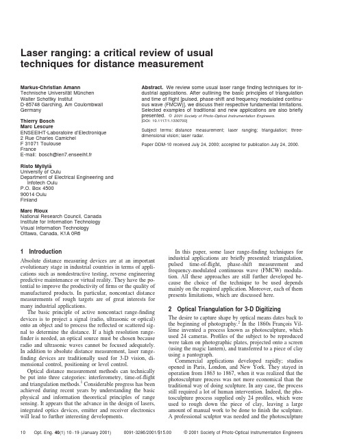
Laser ranging:a critical review of usual techniques for distance measurementMarkus-Christian AmannTechnische Universita¨t Mu¨nchenWalter Schottky InstitutD-85748Garching,Am Coulombwall GermanyThierry BoschMarc LescureENSEEIHT-Laboratoire d’Electronique2Rue Charles CamichelF31071ToulouseFranceE-mail:bosch@len7.enseeiht.frRisto Myllyla¨University of OuluDepartment of Electrical Engineering and Infotech OuluP.O.Box450090014OuluFinlandMarc RiouxNational Research Council,Canada Institute for Information Technology Visual Information Technology Ottawa,Canada,K1A0R6Abstract.We review some usual laser rangefinding techniques for in-dustrial applications.After outlining the basic principles of triangulation and time offlight[pulsed,phase-shift and frequency modulated continu-ous wave(FMCW)],we discuss their respective fundamental limitations. Selected examples of traditional and new applications are also briefly presented.©2001Society of Photo-Optical Instrumentation Engineers.[DOI:10.1117/1.1330700]Subject terms:distance measurement;laser ranging;triangulation;three-dimensional vision;laser radar.Paper DDM-10received July24,2000;accepted for publication July24,2000.1IntroductionAbsolute distance measuring devices are at an important evolutionary stage in industrial countries in terms of appli-cations such as nondestructive testing,reverse engineering predictive maintenance or virtual reality.They have the po-tential to improve the productivity offirms or the quality of manufactured products.In particular,noncontact distance measurements of rough targets are of great interests for many industrial applications.The basic principle of active noncontact range-finding devices is to project a signal͑radio,ultrasonic or optical͒onto an object and to process the reflected or scattered sig-nal to determine the distance.If a high resolution range-finder is needed,an optical source must be chosen because radio and ultrasonic waves cannot be focused adequately. In addition to absolute distance measurement,laser range-finding devices are traditionally used for3-D vision,di-mensional control,positioning or level control.Optical distance measurement methods can technically be put into three categories:interferometry,time-of-flight and triangulation methods.1Considerable progress has been achieved during recent years by understanding the basic physical and information theoretical principles of range sensing.It appears that the advance in the design of lasers, integrated optics devices,emitter and receiver electronics will lead to further interesting developments.In this paper,some laser range-finding techniques forindustrial applications are briefly presented:triangulation,pulsed time-of-flight,phase-shift measurement andfrequency-modulated continuous wave͑FMCW͒modula-tion.All these approaches are still further developed be-cause the choice of the technique to be used dependsmainly on the required application.Moreover,each of thempresents limitations,which are discussed here.2Optical Triangulation for3-D DigitizingThe desire to capture shape by optical means dates back tothe beginning of photography.2In the1860s Franc¸ois Vil-le`me invented a process known as photosculpture,whichused24cameras.Profiles of the subject to be reproducedwere taken on photographic plates,projected onto a screen ͑using the magic lantern͒,and transferred to a piece of clay using a pantograph.Commercial applications developed rapidly;studiosopened in Paris,London,and New York.They stayed inoperation from1863to1867,when it was realized that thephotosculpture process was not more economical than thetraditional way of doing sculpture.In any case,the processstill required a lot of human intervention.Indeed,the pho-tosculpture process supplied only24profiles,which wereused to rough down the piece of clay,leaving a largeamount of manual work to be done tofinish the sculpture.A professional sculptor was needed and the photosculpture10Opt.Eng.40(1)10–19(January2001)0091-3286/2001/$15.00©2001Society of Photo-Optical Instrumentation Engineersprocess required quite an investment in terms of cameras, projection and reproduction systems,and skilled labor to operate them.It is only with the advent of computers that the process has regained substantial interest,more than100 years later.The surface shape of objects can be imaged and digi-tized using the following basic components:a light source to define a specific pixel͑s͒,such as an encoding-decoding process͑e.g.,triangulation,fringe and pattern projections, and time offlight͒,a sensing device composed of a collect-ing lens and a photodetector that converts light energy to electrical signal,an analog-to-digital converter,andfinally a computer to process,display,and store the raw data.3The following reviews the basic concepts behind optical triangulation for3-D digitizing applications.It emphasizes the critical elements of optimal design and the limitations related to the use of coherent light.It is shown,for ex-ample,that speckle noise is a fundamental limit for the position sensing of laser spot centroid.This has an impact on the choice of the position sensor geometry.Designguidelines are also presented.2.1Light SourceConventional light sources can and are used for optical tri-angulation,but laser sources have unique advantages for 3-D imaging.One of these is brightness,which cannot be obtained by an incoherent emitter.Another is the spatial coherence that enables the laser beam to‘‘stay in focus’’when projected on the scene.Nevertheless,this property is limited by the law of diffraction,which is written here as the propagation͑along the z axis͒of Gaussian laser beams.͑z͒ϭ0ͫ1ϩͩz02ͪ2ͬ1/2,͑1͒and,defining depth offield D f using the Rayleigh criterion gives:D fϭ202/,͑2͒which shows that the depth offield D f is larger when the laser wavelengthis small͑toward the blue͒and/or when the laser beam spot size0is large.A detailed analysis is given in Ref.4.Figure1shows a graph of the preceding equation when a pixel͑voxel͒is sampled every0in the X,Y,and Z directions.On the horizontal axis are the physical dimen-sions of the‘‘volume of view’’along the X,Y,and Z di-rections,assuming that the volume of view is a cube.Ver-tically are the number of pixels͑voxels͒resolved along the three-axis.A few typical laser wavelengths are shown.This graph can be used as a guide when designing an optical system for imaging shapes.It shows the maximum number of pixels͑in terms of information transfer͒that can be ex-tracted from a specific volume.As an example,for a cube that is50cm on a side,one has access to more than2000 resolved spots in each direction axis X,Y,and Z using visible wavelength laser light,which correspond to a cubic element͑voxel͒of200m on the surface of the illumi-nated object.2.2Optical Triangulation GeometryOn scattering,the spatial coherence of the laser light is lost,which means that the depth offield used at the projectioncan be useful only if the lens aperture is closed down at thecollection.Otherwise the focused laser spot is imaged as ablurred disk of light on the photodetector.A solution to thisproblem is to modify the conventional imaging geometry toconform to the Scheimpflug condition.Essentially this geometry enables the photodetector sur-face to‘‘stay in focus’’with the projected laser light.Itsconstruction is very simple when the focal planes of thelens are used.Indeed,it is known that a point on the pro-jection axis located at f͑point1͒will be imaged at infinity ͑Fig.2͒.Consequently the inclination angle of the photode-tector is defined by drawing a line between that point andthe principal point of the collecting lens͑line1͒.Similarly,on the other side of the lens,one knows that a point atinfinity will be imaged at a distance f from the lens.Theinclination and position of the photodector are then ob-tained by constructing a line͑line2͒parallel to line1pass-ing through the point2.2.3Fundamental LimitsSampling the shape along the X and the Y axes is usuallydone in a straightforward manner͓time or space interval,depending on the geometry of the photodetector͑s͔͒.Sam-Fig.1Image resolution of a diffraction-limited optical3-D laser scanner for four typical laserwavelengths.Fig.2Geometric construction of the Scheimpflug condition.11 Optical Engineering,Vol.40No.1,January2001pling along the third dimension ͑Z axis ͒often requires im-age pattern centroid location and interpolation.This is where coherence shows its limitation.Indeed,because of the coherent nature of the laser projection,the imaged laser spot on the photodetector ͑s ͒is corrupted with speckle noise.Here again,the geometry of the optical system and the wavelength of the light are the parameters.Figure 3shows how speckle noise adds to the uncer-tainty of an imaged laser spot.The origin of the modulation observed in the profile is related to the scattering of a pure wavelength when diffusion occurs at the surface of the ob-ject.Within the projected laser spot,each scatterer can be regarded as a coherent emitter,and because there are many of them within the area of illumination the resulting image is the coherent sum of spatially incoherent sources.The result is a random modulation multiplying the expected smooth light profile.In Ref.5,the relationship between the geometrical parameters is established as:2ϭ2f 02/2͑cos ͒2,͑3͒where 2is the position variance,the wavelength of the laser light,f 0is the lens-CCD distance on the optical axis,is the aperture of the collecting lens,and is the Sche-impflug angle.When typical values are given for each parameter,the centroid uncertainty is found to be of the order of a few micrometers,and more interesting,the physical dimensions of the photosensor elements have no effect on that limit.Consequently,the larger the photosensors,the better are the performances of the 3-D digitizer in terms of sensitivity,speed,and depth of view.In practice,using wider photo-sensor elements means that the interpolation is done over a wider dynamic range.As an example,if the speckle noise limits is at 2m and the photosensor width is at 16m,one requires only 5bits of numerical interpolation.On the other hand,if the photosensor width is 50m,7bits of interpolation are required.Notice that at least 2bits are added to the ratio to reduce quantization ͑or numerical ͒noise to a negligible level.2.4ColorA very simple way to add color to a digitized shape is illustrated in Fig.4,which is essentially the same optical triangulation geometry as in Fig.2,with two modifications.Here the single wavelength laser is replaced by a RGB laser or a multiwavelength laser consisting of arbitrary colors in arbitrary numbers.As an example,an Ar-Kr gas laser emits simultaneously more than 10colors in the visible part of the spectrum.Each can be used to make color measure-ments.This is the modification at the projection level.The second modification is made at the collection level.A prism ͑or a wedge ͒is used to disperse the multiwave-length laser beam into multiple beams,each having an am-plitude related to the ‘‘color’’of the illuminated point on the surface of the object.An interesting feature of this ge-ometry is that the shape and color are digitized simulta-neously,enabling a perfect registration of geometric and color data.2.5ConclusionDigitizing shapes requires careful design consideration.For all active approaches including optical triangulation,the most critical element in order to achieve high-resolution imaging is the projection system,not the collecting system.In fact,in some cases it is found that optimum perfor-mances are obtained where the photosensor elements are of larger sizes.This is quite the opposite of the current trend in conventional 2-D imaging.Applications of 3-D digitiz-ing cover a wide spectrum from industrial design,manufac-turing,simulation,inspection,and visual communication.3Laser Pulse Time-of-Flight Distance Measurement3.1IntroductionThe laser pulse time-of-flight ͑TOF ͒distance measuring technique was originally used in military and surveying ap-plications.It refers to the time it takes for a pulse of energy to travel from its transmitter to an observed object and then back to the receiver (t d ).If light is used as energy source,the relevant parameter involved in range counting is the speed of light ͑roughly c ϭ30cm/ns ͒.A TOF system mea-sures the round trip time between a light pulse emission and the return of the pulse echo resulting from its reflectance off an ing elementary physics,distance is deter-mined by multiplying the velocity of light by the time light takes to travel the distance.In this case,the measured time is representative of traveling twice the distance andmust,Fig.3Speckle noise limits the position sensingresolution.Fig.4Geometry for simultaneous recording of shapes and colors.12Optical Engineering,Vol.40No.1,January 2001therefore,be reduced by half to give the actual range to the target.To obtain 1mm accuracy,the accuracy of the time interval measurement should be 6.7ps.Since a single pulse is adequate for the unequivocal de-termination of distance with centimeter precision and accu-racy depends only weakly on distance,this method is par-ticularly appropriate,for example,in applications involving distances longer than 1m,applications where reflectors are not used and fast measurement applications such as scan-ning.In addition,averaging enables millimeter or even sub-millimeter precision to be achieved.The advantage of the TOF system arises from the direct nature of its sensing as both the transmitted and returned signals follow essentially the same direct path to an object and back to the receiver.Some new applications such as sensors in robotics,au-tonomous vehicles and rendezvous and docking,along with anticollision and proximity sensors and sensors used in pro-tecting an area in front of a machine demand limitations on instrument size,mass and power consumption.To achieve these goals,the basic building blocks of a TOF range finder have to be realized in the form of high-performance inte-grated circuits.Bosch and Lescure provide an excellent re-view of absolute distance measurement in one of the SPIE Milestone volumes.13.2ConstructionsA pulsed TOF distance measuring device consists of a laser transmitter emitting pulses with a duration of 5to 50ns,a receiver channel including a p-i-n or an avalanche photodi-ode,amplifiers,an automatic gain control ͑AGC ͒and tim-ing discriminators.The emitted light pulse ͑start pulse ͒trig-gers the time interval measurement unit,and the reflected light pulse ͑stop pulse ͒stops it.The distance to the target is proportional to the time interval.A block diagram of a laser range finder is shown in Fig.5.The selection of laser type depends on the intended mea-surement range and the required speed.For long distances ͑up to several kilometers ͒,a Nd:YAG laser can be used,giving peak powers extending to the megawatt level.Low-priced pulsed laser diodes ͓single heterostructure ͑SH ͒or double heterostructure ͑DH ͒-type ͔,capable of producing peak powers of tens of watts,enable measuring distances up to a few hundreds of meters—or even longer using co-herent summing.The repetition frequency of YAG lasers is low,whereas laser diodes can be used at rates of tens of kilohertz,the DH-type may even reach the megahertz level.In 3-D measurements,the laser range finder is equipped with angle encoders to enable the definition of the coordi-nates of the measurement point.Scanning is mechanical and is carried out manually or automatically.In some ap-plications,manual scanning is adequate but for time-critical purposes a servo system is required to increase the mea-surement rate.Basic techniques include scanning either the measuring head or only the measuring beam by means of galvanometer-driven mirrors.Focal plane scanning can be used instead of a narrow laser beam,which scans a surface mechanically,point by point.This enables a range map to be obtained without mechanical beam scanning.The result is highly improved 3-D mapping performance,particularly with respect to measuring time,at considerably reduced mechanical com-plexity and thus reduced size and power requirements.The principle of focal plane scanning is presented in Fig.6.The laser beam illuminates the total field of view on the surface.A target’s surface is viewed using matrices of separate detectors.Each detector covers its own fraction of the field of view illuminated by the laser.Detector signals are analyzed in the time domain,and distances to particular points are calculated on the basis of time interval measure-ments.The system can simultaneously measure distances to several directions without any moving parts.63.3Timing Jitter and Walk,Nonlinearity and Drift The main sources of inaccuracy in laser rangefinders are noise-generated timing jitter,walk,nonlinearity and drift.Typical noise sources include noise generated by the elec-tronics,shot noise caused by the background radiation-induced current and shot noise created by the noise of the signal current.Jitter in timing determines mainly the preci-sion of the range measurement.The amount of timing jitter is proportional to noise amplitude ͓root mean square ͑rms ͔͒and inversely proportional to the slope of the timing pulse at the moment of timing (d u /d t ).A single-shot resolution of 1cm can typically be achieved with a good signal (SNR ϭ100)using the 100MHz bandwidth of the receiver channel.However,precision deteriorates as the distance in-creases and the pulse amplitude decreases proportional to the square of the distance.7Pulse amplitude and shape variations create timing error in the time-pickoff circuit and that error is called walk error.Jitter and walk in leading edge timing are shown in Fig.7.Fig.5Block diagram of TOF laser rangefinder.Fig.6Schematic of focal plane scanning.13Optical Engineering,Vol.40No.1,January 2001The time discriminator is a very important part of a pre-cision time measurement system.The task of the discrimi-nator is to observe time information from the electric pulseof the detector preamplifier and to produce a triggering sig-nal at the right instant.The choice of time derivationmethod depends on the desired time resolution,countingrate and required dynamic range of the monlyused principles in discriminator design include leadingedge timing͑constant amplitude͒,zero crossing timing ͑derivation͒,first moment timing͑integration͒,and constant fraction timing.Constant fraction discrimination͑CFD͒compensates with idealized pulse shapes for walk causedby both amplitude and risetime and is commonly used inthe TOF measuring units of laser rangefinders.The principle behind the operation of CFD is the searchfor an instant in the pulse when its height bears a constantratio to pulse amplitude.The occurrence of this point pro-duces a triggering pulse.The constant fraction instant canbe examined with a high gain differential emitter-coupledlogic͑ECL͒comparator,which amplifies the difference ofthe attenuated and the delayed pulses.8CFD compensatesfor walk caused by amplitude and rise time,but not forwalk caused by unlinear shape variations.Zero crossingandfirst moment timing compensate for amplitude varia-tions,while leading edge timing fails to compensate for anyvariation described.The transmitter,gain-control and time-interval measure-ment units are also critical for the accuracy of the system.The transmitter should be able to produce a stable laserpulse shape.This may call for the temperature stabilizationof the diode.The dynamic phenomena of the laser diodes,relaxation oscillations,should also be considered when de-signing the pulsing scheme as they may easily lead to sig-nificant changes in laser pulse shape.Gain control is needed to adjust the dynamics of thetiming pulse to that of the timing discriminator.Theamount of control needed depends on the measurementrange,construction of the optics and reflectivity variationsof the object.An adjustable optical attenuator at the re-ceiver optics can be used to realize gain control.The ad-vantage of this method over electrical gain control is itsdelay stability over a wide control range.Recently,the dy-namic range of electronic gain control methods has in-creased quite remarkably.9The time interval between the start and stop pulses ismeasured with the time-to-digital converter͑TDC͒,whichis a fast,accurate and stable time-interval measuring devicethat uses,e.g.,a digital counting technique together with ananalog or digital interpolation method.10The single shotresolution of the TDC is typically better than the noisegenerated timing jitter.Thefinal precision of the distance measurement can be greatly improved by averaging,with the improvement be-ing proportional to the square root of the number of results averaged.Thus,by averaging100successive measure-ments,thefinal resolution can be improved to the millime-ter level,the corresponding measurement time being1ms with a pulsing rate of100kHz,for instance.If the statistical error is averaged to a negligible level, the accuracy of the system is defined by its systematic er-rors such as nonlinearity in the time interval measurement scale and drift.A careful design of the system can reduce these errors to the millimeter level.3.4New Applications and Development Trends Several new applications for the transit time measurement of laser pulses are currently being developed to supplement traditional ones.A promising method involves using the path length of light pulses in human tissue,pulp and paper or opticalfiber as a sensor principle.In this context,the term photon migration is often used to describe the propa-gation of light in scattering media like human tissue.In turbid media,photons take a number of different paths thereby broadening short light pulses.The use of TOF tech-niques for imaging soft tissues͑optical tomography͒is be-ing actively investigated by many researchers today for ap-plications such as breast cancer diagnosis and imaging the oxygenation state of the brain in newborn infants.11From the point of view of the paper industry,one of the most important properties of graphic paper is the interaction of light and paper structure.One method of obtaining a more detailed understanding of the propagation of light in paper and pulp is the high-resolution measurement of the delay light pulses suffer as they pass through a sheet of paper or a sample of pulp.12As for composite materials,opticalfi-bers can be embedded in them during the manufacturing process.Calculations are then based on the fact that the TOF of the light pulse in afiber is a function of the length and refractive index of thefiber,which are affected by stress,temperature and pressure.13Commercial applications in the civilian sector place sev-eral demands on laser-based devices.First,the so-called class1laser condition͑eye-safety͒that limits the peak power of the laser to a few watts should be fulfilled.How-ever,the reliable detection of low-reflectance or high-temperature targets requires a sufficiently high optical peak power.The use of picosecond pulses helps to overcome the eye-safety problem,but at the cost of a receiver with high bandwidth.Shorter pulses also give better precision.14 Other highly desirable qualities of the rangefinder include cost-effectiveness.The size,weight and power consump-tion of the device should be reduced to increase its potential application range.These goals can be achieved using full custom application-specific integrated circuits͑ASIC͒.A long-term vision could be to realize the TOF rangefinder as a component-like microsystem where all the basic elements ͑laser diode,photodetector,receiver channel and time inter-val measurement electronics͒are located on a single encap-sulated hybridcircuit.Fig.7Timing jitter and walk.14Optical Engineering,Vol.40No.1,January20014Principle and Limitations of a Laser Phase-Shift Range Finder4.1IntroductionThe principle of a laser phase-shift range finder is described in this section.Heterodyne technique gives a narrow band-width amplification which improves the SNR.The limita-tions such as high level of the photoelectric signal,inter-mediate frequency drift and electrical crosstalk are discussed.4.2Physical Principle of a Phase-Shift Rangefinder In a phase-shift rangefinder,the optical power is modulated with a constant frequency.The basic operating scheme of the device is shown in Fig.8.A sine wave of frequency f rf generated by the main oscillator modulates the dc current of the laser diode.After reflection from the target,a photo-diode collects a part of the laser beam.Measurement of the distance D is deduced from the phase shift ⌬ϭ2f rf ⌬t between the photoelectric current and the modulated emit-ted signal:D ϭ12c⌬2f rf,͑4͒where c is the speed of light in free space and ⌬t is the TOF.When ⌬ϭ2,the unambiguous distance measure-ment is limited to ⌳ϭc f rf /2͑for example,⌳ϭ9m with f rf ϭ16.66MHz ͒.To ameliorate the accuracy of this setup,the phase shift is not directly measured at the working high frequency but at an intermediate frequency f rf ϭ͉f rf Ϫf ol ͉using a heterodyne technique that preserves the phase shift versus distance.The signals of the two mixers outputs are filtered by a passband circuit tuned on f if and with a ⌬f if bandwidth.4.3Received Signal PowerWhen the target area is as large as the area illuminated by the transmitter,the received signal power P R is given by the relationship:P R ϭT T T Rd P 0cos A RD2,͑5͒whereP 0ϭpower output of the laser diodeT T ϭcollection and transmission efficiency oftransmitterT R ϭtransmission of the receiver opticsd ϭLambertian reflection coefficient of the target ϭlaser beam incident angle on the target A R ϭarea of receiver lenses.Only,the Lambertian component is used for the calcu-lation of the photoelectric signal;the specular component is ignored in Eq.͑5͒.As a matter of fact,the term d P 0/is the power intensity ͑in watts per steradion ͒reflected per-pendicular to the target surface.For some representative construction materials ͑such as standard printing white paper,unpainted wood,unpolished coating,satin-like coating ͒the values of d are between 0.6and 0.7for a wavelength ϭ820nm ͑Ref.15͒.With ϭ950nm,values can vary from 0.4to 0.8͑Ref.16͒.4.4Error Analysis4.4.1High levels on the rf channelThe power budget shows that the ratio P R /P 0may vary with a factor greater than 1000if the distance D varies for example from 1to 10m.Thus,when the photoelectric sig-nal amplitude varies with a factor 1000,the phase-shift error ␦introduced by this variation must be less than 0.1deg for an error distance measurement ␦D of 2.5mm.But,with large amplitude of the useful signal,distortion and clipping introduce phase-shift errors.To avoid this error,the first solution is the defocusing of the photodiode,so that it receives less light when measured distances are small.A second solution is increasing the feedback of the mixer to avoid distortion and clipping.174.4.2Intermediate frequency driftWith a low-power laser diode,a narrow bandwidth ampli-fication improves the SNR.For a white noise at the input,the output of a passband second-order filter presents a noise-equivalent bandwidth B n given by the relationship 18:B n ϭ͑/2͒⌬f rf .͑6͒Thus,the rms noise of the useful signal is proportionalto the square root of the bandwidth ⌬f if .Because of sym-metry,it can be supposed that the frequency drift ␦f rf or ␦f ol of one oscillator balances the drift of the other one.No error is present if the two intermediate frequency filters are identical on reference channel and signal channel.But if the value of the bandwidth is too narrow,we must take into account the device mismatch effects introduced in interme-diate frequency tuned circuits by the frequency drifts of f rf and f ol .For example,for Rauch filter structure,the quality factor Q ϭf if /⌬f if and the tuned frequency f if mismatches are imposed by the presence of capacitance mismatches.With f rf ϭ16.66MHz,⌬f if ϭ200Hz,assuming a capaci-tance mismatch of 1%,to achieve a phase-shifterrorFig.8Block diagram of a phase-shift laser rangefinder using a het-erodyne technique.15Optical Engineering,Vol.40No.1,January 2001。

测量专业常用英语词汇阿贝比长原理Abbe comparator principle阿达马变换Hadamard transformation安平精度setting accuracy岸台,*固定台base station暗礁reef靶道工程测量target road engineering survey 半导体激光器semiconductor laser半日潮港semidiurnal tidal harbor半色调halftone饱和度saturation北极星任意时角法method by hour angle of Polaris贝塞尔大地主题解算公式Bessel formula for solution of geodetic problem贝塞尔椭球Bessel ellipsoid贝叶斯分类Bayesian classification被动式遥感passive remote sensing本初子午线prime meridian比较地图学comparative cartography比较地图学comparative cartography比例尺scale比例量表ratio scaling比例误差proportional error比值变换ratio transformation比值增强ratio enhancement闭合差closing error闭合差closure闭合差closing error闭合差closure闭合导线closed traverse闭合导线closed traverse闭合水准路线closed leveling line闭合水准路线closed leveling line边长中误差mean square error of side length 边交会法linear intersection边角测量triangulateration边角交会法linear-angular intersection边角网triangulateration network边缘检测edge detection边缘增强edge enhancement编绘compilation编绘compilation编绘原图compiled original 编绘原图compiled original变比例投影varioscale projection变换光束测图affine plotting变线仪variomat变形观测控制网control network for deformation observation变形观测控制网control network for deformation observation变形椭圆indicatrix ellipse标称精度nominal accuracy标称精度nominal accuracy标尺rod标尺staff标高差改正correction for skew normals标高差改正correction for skew normals标界测量survey for marking of boundary标志灯,*回光灯signal lamp标准差standard deviation标准配置点Gruber point标准纬线standard parallel冰后回弹post glacial rebound波茨坦重力系统Potsdam gravimetric system波带板zone plate波浪补偿compensation of undulation波浪补偿compensation of undulation波浪补偿heave compensation波浪补偿器,*涌浪滤波器heave compensator波罗-科普原理Porro-Koppe principle波谱测定仪spectrometer波谱集群spectrum cluster波谱特征空间spectrum feature space波谱特征曲线spectrum character curve波谱响应曲线spectrum response curve波束角beam angle波束角wave beam angle泊位Berth补偿器compensator补偿器compensator补偿器补偿误差compensating error of compensator补偿器补偿误差compensating error of compensator布格改正Bouguer correction布格异常Bouguer anomaly布隆斯公式Bruns formula布耶哈马问题Bjerhammar problem采剥工程断面图striping and mining engineering profile采剥工程综合平面图synthetic plan of striping and mining采场测量stope survey采掘工程平面图mining engineering plan采区测量survey in mining panel采区联系测量connection survey in mining panel采区联系测量connection survey in mining panel采样sampling采样间隔sampling interval彩色编码color coding彩色编码color coding彩色变换color transformation彩色变换color transformation彩色复制color reproduction彩色复制color reproduction彩色感光器材color sensitive material彩色感光器材color sensitive material彩色红外片,*假彩色片false color film彩色红外片,*假彩色片color infrared film 彩色红外片,*假彩色片color infrared film 彩色片color film彩色片color film彩色摄影color photography彩色摄影color photography彩色校样color proof彩色校样color proof彩色样图color manuscript彩色样图color manuscript彩色增强color enhancement彩色增强color enhancement彩色坐标系color coordinate system彩色坐标系color coordinate system参考数据reference data参考椭球reference ellipsoid参考效应reference effect参数平差,*间接平差parameter adjustment 侧方交会side intersection侧扫声呐side scan sonar侧视雷达side-locking radar测标[measuring] mark测杆measuring bar测高仪Altimeter测绘标准standards of surveying and mapping测绘联合会International Union of Surveying and Mapping测绘学geomatics测绘学SM测绘学surveying and mapping测绘仪器instrument of surveying and mapping测角中误差mean square error of angle observation测距定位系统,*圆-圆定位系统range positioning system测距雷达range-only radar测距盲区range hole测距仪rangefinder测量标志survey mark测量船survey vessel测量规范specifications of surveys测量控制网surveying control network测量平差adjustment of observation测量平差survey adjustment测量学surveying测流current surveying测流current surveying测深改正correction of depth测深改正correction of depth测深杆sounding pole测深精度total accuracy of sounding测深仪读数精度reading accuracy of sounder测深仪发射参数,*测深仪零线transmiting line of sounder测深仪回波信号echo signal of sounder测深仪记录纸recording paper of sounder测速标marks for measuring velocity测图卫星mapping satellite测微密度计microdensitometer测微目镜micrometer eyepiece测微器micrometer测线survey line测站station测站归心station centring层间改正plate correction觇牌target长度标准检定场standard field of length厂址测量surveying for site selection超导重力仪superconductor gravimeter超焦点距离hyperfocal distance超近摄影测量macrophotogrammetry潮汐表tidal tables潮汐波tidal wave潮汐调和常数tidal harmonic constants潮汐调和分析tidal harmonic analysis潮汐非调和常数tidal nonharmonic constants潮汐非调和分析tidal nonharmonic analysis 潮汐摄动tidal perturbation潮汐因子tidal factor潮汐预报tidal prediction潮信表tidal information panel沉船wreck沉降观测settlement observation成像光谱仪imaging spectrometer成像雷达imaging radar城市测量urban survey城市地形测量urban topographic survey城市地形图topographic map of urban area 城市基础地理信息系统UGIS城市基础地理信息系统urban geographical information system城市控制测量urban control survey城市制图urban mapping乘常数multiplication constant尺度参数scale parameter抽象符号abstract symbol触觉地图tactual map船台,*移动台mobile station垂核面vertical epipolar plane垂核线vertical epipolar line垂球plumb bob垂线偏差改正correction for deflection of the vertical垂线偏差改正correction for deflection of the vertical垂直角vertical angle垂直折光误差vertical refraction error垂直折光系数vertical refraction coefficient 垂准仪,*铅垂仪plumb aligner纯重力异常pure gravity anomaly磁变年差annual change of magnetic variation磁测深magnetic sounding磁测深线magnetic sounder磁方位角magnetic azimuth磁力扫海测量magnetic sweeping磁力异常区magnetic anomaly area磁偏角magnetic variation磁倾角magnetic dip磁像限角magnetic bearing磁子午线magnetic meridian粗差gross error粗差检测gross error detection粗码C/A Code粗码Coare/Acquision Code粗码C/A Code粗码Coare/Acquision Code打样Proofing大比例尺测图large scale topographical mapping大潮升spring rise大地测量边值问题geodetic boundary value problem大地测量参考系geodetic reference system 大地测量数据库geodetic database大地测量学geodesy大地测量仪器geodetic instrument大地方位角geodetic azimuth大地高ellipsoidal height大地高geodetic height大地基准geodetic datum大地经度geodetic longitude大地水准面geoid大地水准面高geoidal height大地水准面高geoidal undulation大地天顶延迟atmosphere zenith delay大地天文学geodetic astronomy大地网geodetic network大地纬度geodetic latitude大地线geodesic大地原点geodetic origin大地主题反解inverse solution of geodetic problem大地坐标geodetic coordinate大地坐标系geodetic coordinate system大陆架地形测量continental shelf topographic survey大陆架地形测量continental shelf topographic survey大气传输特性characteristics of atmospheric transmission大气传输特性characteristics of atmospheric transmission大气窗atmospheric window大气改正,*气象改正atmospheric correction 大气透过率atmospheric transmissivity大气噪声atmospheric noise大气阻力摄动atmospheric drag perturbation 大像幅摄影机large format camera大像幅摄影机LFC大洋地势图GEBCO大洋地势图general bathymetric chart of the oceans大圆航线图great circle sailing chart带谐系数coefficient of zonal harmonics带谐系数coefficient of zonal harmonics带状平面图zone plan单差相位观测single difference phase observation单点定位point positioning单片坐标量测仪monocomparator单位权unit weight单位权方差,*方差因子variance of unit weight弹道摄影测量ballistic photogrammetry弹道摄影机ballistic camera当地平均海面local mean sea level挡差改正correction of scale difference挡差改正correction of scale difference导标leading beacon 导弹定向测量missile orientation survey导弹试验场工程测量engineering survey of missile test site导航台定位测量navigation station location survey导航台定位测量navigation station location survey导航图navigation chart导航图navigation chart导航线,*叠标线leading line导入高程测量induction height survey导线边traverse leg导线测量traverse survey导线点traverse point导线横向误差lateral error of traverse导线角度闭合差angle closing error of traverse导线结点junction point of traverses导线曲折系数meandering coefficient of traverse导线全长闭合差total length closing error of traverse导线网traverse network导线相对闭合差relative length closing error of traverse导线折角traverse angle导线纵向误差longitudinal error of traverse 岛屿测量island survey岛屿联测island-mainland connection survey 岛屿图island chart倒锤[线]观测,倒锤法inverse plummet observation测量专业常用英语翻译短语或词组-2灯[光性]质characteristic of light灯[光性]质characteristic of light灯标light beacon灯船light ship灯船light vessel灯浮标light buoy灯高height of light灯光节奏flashing rhythm of light灯光射程light range灯光遮蔽Eclipse灯光周期light period灯色light color灯塔light house等比线isometric parallel等高距contour interval等高距contour interval等高棱镜contour prism等高棱镜contour prism等高线Contour等高线Contour等高仪astrolabe等积投影equivalent projection等级结构hierarchical organization等角定位格网equiangular positioning grid 等角条件,*正形投影conformal projection 等角条件,*正形投影conformal projection 等精度[曲线]图equiaccuracy chart等距量表interval scaling等距投影equidistant projection等距圆弧格网equilong circle arc grid等量纬度isometric latitude等偏摄影parallel-averted photography等倾摄影equally tilted photography等权代替法method of equalweight substitution等值灰度尺equal value gray scale等值区域图,*分区量值地图choroplethic map等值区域图,*分区量值地图choroplethic map等值线地图isoline map等值线法isoline method低潮线low water line底板测点floor station底点纬度latitude of pedal底色去除under color removal底色增益under color addition底质bottom characteristics底质quality of the bottom底质采样bottom characteristics sampling底质调查bottom characteristics exploration 底质分布图bottom sediment chart地产界测量property boundary survey 地磁经纬仪magnetism theodolite地磁仪magnetometer地底点ground nadir point地固坐标系body-fixed coordinate system地固坐标系earth-fixed coordinate system地基系统ground-based system地极坐标系coordinate system of the pole地极坐标系coordinate system of the pole地籍cadastre地籍cadastre地籍簿land register地籍册cadastral lists地籍册cadastral lists地籍测量cadastral survey地籍测量cadastral survey地籍调查cadastral inventory地籍调查cadastral inventory地籍更新renewal of the cadastre地籍管理cadastral survey manual地籍管理cadastral survey manual地籍图cadastral map地籍图cadastral map地籍修测cadastral revision地籍修测cadastral revision地籍制图cadastral mapping地籍制图cadastral mapping地界测量land boundary survey地壳均衡isostasy地壳均衡改正isostatic correction地壳形变观测crust deformation measurement地壳形变观测crust deformation measurement地块测量parcel survey地类界图land boundary map地理格网geographic grid地理视距geographical viewing distance地理信息传输geographic information communication地理信息系统geographic information system地理信息系统GIS地理坐标geographic graticule地理坐标参考系geographical referencesystem地貌图geomorphological map地貌形态示量图morphometric map地面接收站ground receiving station地面立体测图仪terrestrial stereoplotter地面摄谱仪terrestrial spectrograph地面摄影测量terrestrial photogrammetry地面摄影机terrestrial camera地面实况ground truth地面照度illuminance of ground地名geographical name地名place name地名标准化place-name standardization地名录gazetteer地名数据库place-name database地名索引geographical name index地名通名geographical general name地名学toponomastics地名学toponymy地名转写geographical name transcription地名转写geographical name transliteration 地平线摄影机horizon camera地平线像片horizon photograph地倾斜观测ground tilt measurement地球定向参数earth orientation parameter地球定向参数EOP地球同步卫星geo-synchronous satellite地球椭球earth ellipsoid地球位,*大地位geopotential地球位数geopotential number地球位系数potential coefficient of the earth 地球形状earth shape地球形状Figure of the earth地球仪globe地球引力摄动terrestrial gravitational perturbation地球重力场模型earth gravity model地球资源卫星earth resources technology satellite地球资源卫星ERTS地球自转参数earth rotation parameter地球自转参数ERP地球自转角速度rotational angular velocity of the earth 地势图hypsometric map地图map地图编绘map compilation地图编辑map editing地图编辑大纲map editorial policy地图表示法cartographic presentation地图表示法cartographic presentation地图传输cartographic communication地图传输cartographic communication地图叠置分析map overlay analysis地图分类cartographic classification地图分类cartographic classification地图分析cartographic analysis地图分析cartographic analysis地图符号库map symbols bank地图符号学cartographic semiology地图符号学cartographic semiology地图负载量map load地图复杂性map complexity地图复制map reproduction地图感受map perception地图更新map revision地图集信息系统Atlas information system地图利用map use地图量算法cartometry地图量算法cartometry地图模型,*制图模型cartographic model 地图模型,*制图模型cartographic model 地图内容结构cartographic organization地图内容结构cartographic organization地图判读map interpretation地图评价cartographic evaluation地图评价cartographic evaluation地图潜信息cartographic potential information地图潜信息cartographic potential information地图清晰性map clarity地图色标color chart地图色标color chart地图色标map color standard地图色谱map color atlas地图设计map design地图数据结构map data structure地图数据库cartographic database地图数据库cartographic database地图数字化map digitizing地图投影map projection地图显示map display地图信息cartographic information地图信息cartographic information地图信息系统cartographic information system地图信息系统CIS地图信息系统cartographic information system地图信息系统CIS地图选取cartographic selection地图选取cartographic selection地图学cartography地图学cartography地图研究法cartographic methodology地图研究法cartographic methodology地图易读性map legibility地图印刷map printing地图语法cartographic syntactics地图语法cartographic syntactics地图语言cartographic language地图语言cartographic language地图语义cartographic semantics地图语义cartographic semantics地图语用cartographic pragmatics地图语用cartographic pragmatics地图阅读map reading地图整饰map decoration地图制图map making地图制图软件cartographic software地图制图软件cartographic software地图注记map lettering地下管线测量underground pipeline survey 地下铁道测量subway survey地下铁道测量underground railway survey 地下油库测量underground oil depot survey 地心经度geocentric longitude地心纬度geocentric latitude地心引力常数geocentric gravitational constant地心坐标系geocentric coordinate system 地形测量topographic survey地形底图base map of topography地形改正topographic correction地形数据库topographic database地形图topographic map地形图更新revision of topographic map地形图图式topographic map symbols地震台精密测量precise survey at seismic station地质测量geological survey地质点测量geological point survey地质略图geological scheme地质剖面测量geological profile survey地质剖面图geological section map典型图形平差adjustment of typical figures 点方式point mode点位中误差mean square error of a point点下对中centering under point点下对中centering under point点状符号point symbol电磁波测距electromagnetic distance measurement电磁波测距仪electromagnetic distance measuring instrument电磁传播[时延]改正correction for radio wave propagation of time signal电磁传播[时延]改正correction for radio wave propagation of time signal电荷耦合器件CCD电荷耦合器件charge-coupled device电荷耦合器件CCD电荷耦合器件charge-coupled device电离层折射改正ionospheric refraction correction电子测距仪EDM电子测距仪electronic distance measuring instrument电子出版系统electronic publishing system 电子地图集electronic atlas电子分色机color scanner电子分色机color scanner电子海图electronic map电子海图数据库ECDB电子海图数据库electronic chart database电子海图显示和信息系统ECDIS电子海图显示和信息系统electronic chart display and information system电子经纬仪electronic theodolite电子平板仪electronic plane-table电子求积仪electronic planimeter电子水准仪electronic level电子速测仪,*全站仪electronic tachometer 电子显微摄影测量nanophotogrammetry电子显微摄影测量nanophotogrammetry电子相关electronic correlation电子印像机electronic printer调绘Annotation调焦误差error of focusing调频频率modulation frequency调制传递函数modulation transfer function 调制传递函数MTF调制器modulator叠栅条纹图,*莫尔条纹图moirétopography顶板测点roof station定深扫海sweeping at definite depth定位标记positioning mark定位点间距positioning interval定位检索,*开窗检索retrieval by windows 定位统计图表法positioning diagram method定线测量Alignment survey定向连接点connection point定向连接点connection point for orientation 定向连接点connection point定向连接点connection point for orientation 定性检索retrieval by header定影Fixing动感autokinetic effect动画引导animated steering动画制图animated mapping动态定位kinematic positioning独立交会高程点elevation point by independent intersection独立模型法空中三角测量independent model aerial triangulation独立坐标系independent coordinate system 度盘circle 度盘circle断面仪Profiler对景图front view对流层折射改正tropospheric refraction correction对数尺logarithmic scale对中杆centering rod对中杆centering rod多倍仪multiplex多边形地图polygonal map多边形结构polygon structure多边形平差法Adjustment by method of polygon多波束测探multibeam echosounding多波束测探系统multibeam sounding system 多层结构multi layer organization多级纠正multistage rectification多焦点投影polyfocal projection多路径效应multipath effect多媒体地图multimedia map多年平均海面multi-year mean sea level多谱段扫描仪MSS多谱段扫描仪multispectral scanner多谱段摄影multispectral photography多谱段摄影机multispectral camera多谱段遥感multispectral remote sensing多时相分析multi-temporal analysis多时相遥感multi-temporal remote sensing 多星等高法equal-altitude method of multi-star多用途地籍multi-purpose cadastre多余观测redundant observation多圆锥投影polyconic projection厄特沃什效应Eötvös effect二值图像binary image测量专业常用英语翻译短语或词组-3发光二极管LED发光二极管light-emitting diode法方程normal equation法方程normal equation法截面normal section法截面normal section法伊改正Faye correction反差Contrast反差Contrast反差系数contrast coefficient反差系数contrast coefficient反差增强contrast enhancement反差增强contrast enhancement反立体效应pseudostereoscopy反射波谱reflectance spectrum反束光导管摄影机return beam vidicon camera反像mirror reverse反像wrong-reading反转片reversal film范围法area method方差-协方差传播律variance-covariance propagation law方差-协方差矩阵variance-covariance matrix 方里网kilometer grid方位角中误差mean square error of azimuth 方位圈compass rose方位圈compass rose方位投影azimuthal projection方向观测法method by series方向观测法method of direction observation 防波堤Breakwater防波堤mole房地产地籍real estates cadastre仿射纠正affine rectification放样测量setting-out survey非地形摄影测量nontopographic photogrammetry非地形摄影测量nontopographic photogrammetry非监督分类unsupervised classification非量测摄影机non-metric camera非量测摄影机non-metric camera菲列罗公式Ferrero's formula分版原图Flaps分瓣投影interrupted projection分层layer分层设色表graduation of tints分层设色法hypsometric layer分潮Constituent 分潮Constituent分潮迟角epoch of partial tide分潮振幅amplitude of partial tide分带纠正zonal rectification分带子午线zone dividing meridian分类器classifier分类器classifier分区统计图表法cartodiagram method分区统计图表法chorisogram method分区统计图表法cartodiagram method分区统计图表法chorisogram method分区统计图表法,*等值区域法cartogram method分区统计图表法,*等值区域法cartogram method分区统计图法,*等值区域法choroplethic method分区统计图法,*等值区域法choroplethic method分色,*分色参考图color separation分色,*分色参考图color separation分析地图analytical map风讯信号杆wind signal pole浮标Buoy浮雕影像地图picto-line map浮子验潮仪float gauge符号化symbolization辐射三角测量radial triangulation辐射线格网radial positioning grid辐射校正radiometric correction辐射遥感器radiation sensor负荷潮load tide负片negative负片negative附参数条件平差condition adjustment with parameters附参数条件平差condition adjustment with parameters附合导线connecting traverse附合导线connecting traverse附合水准路线annexed leveling line附加位additional potential附条件参数平差,*附条件间接平差parameter adjustment with conditions复测法repetition method复垦测量reclaimation survey复照仪reproduction camera副台slave station概率判决函数Probability decision function 概然误差probable error干出礁covers and uncovers rock干出礁covers and uncovers rock干涉雷达INSAR干涉雷达interometry SAR感光sensitization感光材料sensitive material感光测定sensitometry感光度sensitivity感光特性曲线characteristic curve of photographic transmission感光特性曲线characteristic curve of photographic transmission感受效果perceptual effect港界harbor boundary港口port港口工程测量harbor engineering survey港湾测量harbor survey港湾锚地图集harbor/anchorage atlas港湾图harbor chart高差仪statoscope高程height高程导线height traverse高程点elevation point高程基准height datum高程控制测量vertical control survey高程控制点vertical control point高程控制网vertical control network高程系统height system高程异常height anomaly高程中误差mean square error of height高度角altitude angle高度角elevation angle高密度数字磁带HDDT高密度数字磁带high density digital tape高斯-克吕格投影Gauss-Krüger projection 高斯平面子午线收敛角Gauss grid convergence高斯平面坐标系Gauss plane coordinate system高斯投影方向改正arc-to-chord correction in Gauss projection高斯中纬度公式Gauss midlatitude formula 格网单元cell格网单元cell跟踪数字化tracing digitizing工厂现状图测量survey of present state at industrial site工程测量engineering survey工程测量学engineering surveying工程经纬仪engineer's theodolite工程控制网engineering control network工程摄影测量engineering photogrammetry 工程水准仪engineer's level工业测量系统industrial measuring system 工业摄影测量industrial photogrammetry公路工程测量road engineering survey功率谱power spectrum共面方程coplanarity equation共面方程coplanarity equation共线方程collinearity equation共线方程collinearity equation构像方程imaging equation古地图ancient map骨架航线,*构架航线,测控条control strip 骨架航线,*构架航线,测控条control strip 固定平极fixed mean pole固定误差fixed error固定相移fixed phase drift固体潮[solid] Earth tide固体激光器solid-state laser管道测量pipe survey管道综合图synthesis chart of pipelines贯通测量holing through survey贯通测量breakthrough survey惯性测量系统inertial surveying system惯性测量系统ISS惯性坐标系inertial coordinate system惯用点conventional name惯用点conventional name灌区平面布置图irrigation layout plan光电测距导线EDM traverse光电测距仪electro-optical distancemeasuring instrument光电等高仪photoelectric astrolabe光电遥感器photoelectric sensor光电中星仪photoelectric transit instrument 光碟,*光盘CD光碟,*光盘compact disc光碟,*光盘CD光碟,*光盘compact disc光谱感光度,*光谱灵敏度spectral sensitivity光圈,*有效孔径Aperture光圈号数f-number光圈号数stop-number光束法空中三角测量bundle aerial triangulation光栅grating广播星历broadcast ephemeris归化纬度reduced latitude归心改正correction for centering归心改正correction for centering归心元素elements of centring龟纹moire规划地图planning map规矩线register mark国际测绘联合会IUSM国际测量师联合会Fédération Internationale des Géométres国际测量师联合会FIG国际大地测量协会IAG国际大地测量协会International Association of Geodesy国际大地测量与地球物理联合会International Union of Geodesy and Geophysics国际大地测量与地球物理联合会IUGG国际地球参考架international terrestrial reference frame国际地球参考架ITRF国际地球自转服务局IERS国际地球自转服务局International Earth Rotation Service国际海道测量组织IHO国际海道测量组织International Hydrography Organization 国际海图international chart国际航天测量与地球学学院ITC国际矿山测量学会International Society of Mine Surveying国际摄影测量与遥感学会International Society for Photogrammetry and Remote S国际摄影测量与遥感学会ISPRS国际天球参考架ICRF国际天球参考架international celestial reference frame国际协议原点CIO国际协议原点Conventional International Origin国际协议原点CIO国际协议原点Conventional International Origin国际原子时IAT国际原子时international atomic time国际制图协会ICA国际制图协会International Cartographic Association国家地图集national atlas国家地图集national atlas国家基础地理信息系统national fundamental geographic information system 国家基础地理信息系统national fundamental geographic information system 海[洋]图集marine atlas海岸coast海岸coast海岸地形测量coast topographic survey海岸地形测量coast topographic survey海岸图coast chart海岸图coast chart海岸线coast line海岸线coast line海岸性质nature of the coast海岸性质nature of the coast海拔height above sea level海道测量,*水道测量hydrographic survey 海道测量学,*水道测量学hydrography海底成像系统seafloor imaging system海底地貌submarine geomorphology海底地貌图submarine geomorphologic chart海底地势图submarine situation chart海底地形测量bathymetric surveying海底地形图bathymetric chart海底地质构造图submarine structural chart 海底电缆submarine cable海底管道submarine pipeline海底控制网submarine control network海底倾斜改正seafloor slope correction海底声标acoustic beacon on bottom海底施工测量submarine construction survey海底隧道测量submarine tunnel survey海福德椭球Hayford ellipsoid海军导航卫星系统Navy Navigation Satellite System海军导航卫星系统NNSS海军导航卫星系统Navy Navigation Satellite System海军导航卫星系统NNSS海军勤务测量naval service survey海军勤务测量naval service survey海控点hydrographic control point海流计current meter海流计current meter海面地形sea surface topography海区界线sea area bounding line海区资料调查sea area information investigation海区总图general chart of the sea海图Chart海图Chart海图比例尺Chart scale海图比例尺Chart scale海图编号Chart numbering海图编号Chart numbering海图编制Chart compilation海图编制Chart compilation海图标题Chart title海图标题Chart title海图大改正Chart large correction海图大改正Chart large correction海图分幅Chart subdivision海图分幅Chart subdivision海图改正Chart correction 海图改正Chart correction海图投影Chart projection海图投影Chart projection海图图廓Chart boarder海图图廓Chart boarder海图图式symbols and abbreviations on chart 海图小改正Chart small correction海图小改正Chart small correction海图制图charting海图制图charting海图注记lettering of chart海洋测绘marine charting海洋测绘数据库marine charting database海洋测量marine survey海洋测量定位marine survey positioning海洋磁力测量marine magnetic survey海洋磁力图marine magnetic chart海洋磁力异常marine magnetic anomaly海洋大地测量marine geodetic survey海洋大地测量学marine geodesy海洋工程测量marine engineering survey海洋划界测量marine demarcation survey海洋环境图marine environmental chart海洋气象图marine meteorological chart海洋生物图marine biological chart海洋水文图marine hydrological chart海洋水准测量marine leveling海洋卫星Seasat海洋质子采样器marine bottom proton sampler海洋质子磁力仪marine proton magnetometer海洋重力测量marine gravimetry海洋重力仪marine gravimeter海洋重力异常marine gravity anomaly海洋重力异常图Chart of marine gravity anomaly海洋重力异常图Chart of marine gravity anomaly海洋专题测量marine thematic survey海洋资源图marine resource chart航标表list of lights航带法空中三角测量strip aerial triangulation航道channel航道channel航道fairway航道图navigation channel chart航道图navigation channel chart航高flight height航高flying height航海天文历nautical almanac航海天文历nautical almanac航海通告NM航海通告notice to mariners航海通告NM航海通告notice to mariners航海图nautical chart航海图nautical chart航迹track航空摄谱仪aerial spectrograph航空摄影aerial photography航空摄影测量aerial photogrammetry航空摄影测量aerophotogrammetry航空摄影机aerial camera航空图aeronautical chart航空遥感aerial remote sensing航空重力测量airborne gravity measurement 航路指南sailing directions航路指南SD航摄计划flight plan of aerial photography航摄领航navigation of aerial photography航摄领航navigation of aerial photography航摄漏洞aerial photographic gap航摄软片aerial film航摄像片,航空像片aerial photograph航摄质量quality of aerophotography航速speed航天飞机space shuttle航天摄影space photography航天摄影测量,*太空摄影测量space photogrammetry航天遥感space remote sensing航向course航向course航向倾角longitudinal tilt航向倾角pitch航向重叠end overlap 航向重叠fore-and-aft overlap航向重叠forward overlap航向重叠longitudinal overlap航行通告notice to navigator航行通告notice to navigator航行图sailing chart航行障碍物navigation obstruction航行障碍物navigation obstruction合成地图synthetic map合成孔径雷达SAR合成孔径雷达synthetic aperture radar合点控制vanishing point control河道整治测量river improvement survey河外致密射电源,*类星体extragalactic compact radio source核点epipole核面epipolar plane核线epipolar line核线epipolar ray核线相关epipolar correlation盒式分类法box classification method黑白片black-and-white film黑白摄影black-and-white photography恒时钟sidereal clock恒星摄影机stellar camera恒星时sidereal time恒星中天测时法method of time determination by star transit横断面测量cross-section survey横断面测量cross-section survey横断面图cross-section profile横断面图cross-section profile横轴投影transverse projection红外测距仪infrared EDM instrument红外辐射计infrared radiometer红外片infrared film红外扫描仪infrared scanner红外摄影infrared photography红外图像infrared imagery红外遥感infrared remote sensing后方交会resection湖泊测量lake survey互补色地图anaglyphic map互补色镜anaglyphoscope。
Words and expressionsUnit 1geoscience地球科学informatics信息学,情报学monitor监控,监测,监视,控制,追踪,监控器appreciate增值,涨价,赏识,鉴赏,感激dwindle缩小Iso International standardization organization国际标准化组织explicit清楚的,外在的,直率的,(租金等)直接付款的hydrographic与水道测量有关的,与水文地理有关的hydrographic survey海道测量,水道测量practitioner从业者,开业者expertise专门技术,专家的意见flexibility适应性,机动性,挠性Incorporation结合,合并;形成法人组织,组成公司(或社团) coherent一致的,连贯的demise死亡,让位,禅让ut让渡,遗赠,转让blur把(界线,视线等)弄得模糊不清,涂污,污损(名誉等),弄污visualization可视化,清楚地呈现pertaining有关系的,附属…的,为…固有的(to)Imagery肖像(总称),雕刻影像plotting标图,测绘illustrative 说明性的,例证性的entity实体digitize [计]将资料数字化registration注册,报到,登记forestry林产,森林地,林学geology地质学,地质概况geographical地理学的,地理的infrastructure基础下部组织,下部构造navigation导航,航海,航空,领航,航行quarterly一年四次的,每季的evolve (使)发展,(使)进展,(使)进化cadastre地籍簿,地籍,地籍图cadastral surveying地籍测量sensor传感器manipulate(熟练地)操作,使用(机器等),操纵(人或市价、市场),利用state - of - the - art 先进的,一流的geophysics地球物理学oceanography 海洋学retrieval检索,恢复,修补,重获embrace拥抱,互相|拥抱,包含,收买,信奉ti拥抱n.拥抱geomatics测绘学geodesy大地测量学surveying and mapping测绘photogrammetry摄影测量学remote sensing(RS)遥感global positioning system(GPS)全球定位系统atellite positioning卫星定位geographic information systems(GIS)地理信息系统land management土地管理computer graphics计算机图形学Unit 2artiticial人造的,假的,非原产地的analog类似物,相似体chart图表,海图dimensional空间的monument纪念碑permanent monument永久标石monumentation埋石fieldwork野外工作,实地调查,野外作业category种类,类别,[逻]范畴permanent永久的,持久的theodolite[测]经纬仪prerequisite先决条件spheroid球状体,回转椭圆体allowance容许误差,容差,容许量diameter直径equator赤道,赤道线atitude纬度,范围;(用复数)地区longitude经度,经线经度meridian子午线,正午,顶点,全盛时期ad.子午线的,正午的prime meridian本初子午线,木初子午圈线northing北距(向北航行的距离),北进,北航easting东西距,朝东方;东行航程gravity重力,地心引力gravity field重力场curvature曲率,弯曲plumb铅锤,铅弹ad.垂直的t使垂直,探测plumb line铅垂线trigonometry 三角法plane trigonometry平面三角algebra代数学analytical解枥的,分析的analytical geometry解析几chord弦,弦长triangle三角形,三人一组,三角关系spherical球形的,球的sophisticate弄复杂,篡改;使变得世故入sophistication复杂;强词夺理,诡辩geoid [地]大地水准面trench沟渠,堑壕,管沟,电缆沟,战壕Atlantic ocean大西洋Pacific ocean太平洋tangent相切的,切线的n.切线,[数]正切backsight后视foresight前视;远见,深谋远虑refraction折光,折射geodetic surveying大地测量,大地测量学plane surveying平面测量,平面测量学control survey控制测量horizontal survey水平测量,平面测量vertical survey高程测量,垂直测量地形测量topographic surveydetail survey碎部测量land survey( property survey, boundary survey, cadastral survey)地测量,地籍测量route survey路线测量pipe survey管道测量city survey城市测量hydrographic survey水道测量marine survey海洋测量mine survey矿山测量geological survey地质测量Unit 3fundamental基本原则,基本原理Euclidean space欧几里得空间odometer(汽车等的)里程表,自动计在仪(美vehicle交通工具,车辆,媒介物,传达手段revolution旋转,革命circumference 圆周,周围invar铟瓦;不胀钢nickel镍,镍币,(美国和加拿大的)五分镍币alloy合金coefficient系数thermal热的,热量的tacheometry 测视距测量stadia视距,视距仪器ntercept截取,中途阻止telescope望远镜multiply乘,增加,繁殖nominal 名义上的,有名无实的,名字的,[语]名词性的manufacturer制造业者,厂商/consequence结果[逻]推理,推论,因果关系,重要的地位topographic地势的,地形学上的resultant作为结果而发生的,合成的terrain地形electromagnetic电磁的visibility 可见度,能见度,可见性,显著,明显度infrared红外线的n.红外线airborne 空气传播的,空降的,空运的particle粒子,点,极小量,微粒,质点,小品词,语气modulated已凋整[制]的,被调的distance measurement 距离测量precise ranging精密测距pacing步测,定步distance measuring instrument, rangefinder测距仪EDM( electronic distance measurement)电子测距仪geodimeter光速测距仪,光电测electromagnetic distance measuring instrument电磁波测距仪electro- optical distance measuring instrument光电测距仪long - range EDM instrument远程电子测距infrared EDM instrument红外测距仪laser distance measuring instrument, laser ranger激光测距仪microwave distance measuring instrument微波测距仪satellite laser ranger卫星激光测距仪two- color laser ranger双色激光测距仪distance- measuring error测距误差fixed error固定误差proportional error比例误差sighting distance视距multiplication constant乘常数ddition constant加常数stadia multiplication constant视距乘常数stadia addition constant视距加常数standard field of length长度标准检定场/nominal accuracy标称精度stadia hair视距丝,视距线stadia interval视距间隔Unit 3perpendicular 垂直的,正交的Intersect横断(直线)相交,交又projection投影,投射,投影图,地图投影,规划zenith天顶,顶点,顶峰,最高点celestial天上的celestial sphere天球radius半径,范围,辐射光线,有效航程,范围,界线clinometer测角器,倾斜仪sextant六分仪compass罗盘,指南针,圆规protractor量角器clockwise顺时针方向的counterclockwise反时针方向的sexagesimal六十的,六十进位的sexagesimal systen六十分制commence开始,着手bisect切成两份,对(截)开clamp夹子,夹具,夹钳encoder编码器,译码器spindle轴,杆,心轴;锭子,纺锤crystal结晶状的n.水晶,水晶饰品,结晶,晶体liquid crystal displays(LCDs)液晶显示diode二极管lght- emitting diode displays(LEDs)发光二极管显示pendulum钟摆,摇锤compensator补偿器provision供应,(一批)供应品,预备,防备,规定indexing标定指数initialize初始化azimuth方位,方位角bearing方向,方位quadrant象限四分仪horizontal angle水平角vertical angle垂直角depression angle俯角,俯视角zenith distance天顶距elevation angle高度角horizontal circle水平刻度盘vertical circle垂直度盘true north真北geodetic azimuth大地方位角grid bearing坐标方位角gyro azimuth陀螺方位角magnetic azimuth磁方位角method by series, method of direction observation方向观测法method in all combinations全组合测角法Unit 20Us. Department of defense(DOD)美国国防部castellation[天]星座,星群nsure确保,给…保险drag拖拉v拖,拖曳atmospheric drag大气阻力sun- seeking太阳定向panel面板,仪表板,全体陪审员solar panel太阳能电池板nicad镍镉蓄电池nicad battery镍镉蓄电池Colorado美国科罗拉多州(位于美国西部)Hawaii夏威夷,夏威夷岛Ascension阿森松(南大西洋岛屿)Kwajalein夸贾林环礁(位于太平洋西部)reconnaissance勘测,侦察,搜索missile导弹,发射物missile guidance导弹制导pseudorange伪距synchronize同步synchronized同步的GPS( global positioning system)全球定位系统space segment空间部分control segment控制部分user segment用户部分GPS receiver GPS接收机gps constellation gps星座master control station主控站monitor station监控站atomic clock原子钟clock error钟差broadcast ephemeris广播星历precise ephemeris精密星历Coarse acquisition codeprecise code精码pseudorange伪距ionospheric delay电离层延迟tropospheric delay对流层延迟multipath effect多路径效应Selective availability(SA)选择可用性reference receiver基准接收机roving receiver流动接收机receiver antenna接收机天线real- time kinematic(RTK)实时动态定位differential GPS(DGPS)差分GPSdifferential correction差分改正real- time differential correction实时差分改正post - processed differential correction后处理差分改正Unit 23acronym 只取首字母的缩写词distinguish 区别,辨别attribute属性,品质,特征.加于,归结于peel剥,削,剥落supercomputer[计]超型计算机hook钩住,沉迷,上瘾digitizer 数字转换器cartographe地图制作者,制图师,制图员administrator管理员,管理程序implementation执行coordinator协调者,同等的人或物raster[物]光栅vector向量,矢量,带菌者aircraft航行器census人口普查demographic人口统计学的yearbook年鉴ecosystem生态系统overlay覆盖,覆盖图buffering缓冲(作用),减震,隔离Unit 28exemplify例证,例示illumination照明,阐明,启发geothermal地热的,地温的,地热(或地温)产生的photon光子cosmic宇宙的cosmic ra宇宙射线gamma 射线thereon在其上,在那上面,…之后立即moisture湿度,湿气,潮湿irradiance发光,光辉penetrate穿透,渗透,弥漫electron电子molecular[化]分子的,由分子组成的emittance发射度,[热]辐射本领incidence人射,落下的方式,影响范围spacecraft太空船backscatter漫反射,反向散射体,反散射synthetic合成的,人造的,综合的aperture孔,穴,缝隙,(照相机,望远镜等的)光圈,孔径synthetic aperture radar(SAR)合成孔径雷达multispectral多谱线的,多谱段的spectroradiometer[物]分光辐射计side - looking 侧视的remote sensor遥测传感器,遥感器electromagnetic spectrum电磁波频谱,电磁波谱,电磁光谱transmittance传播absorptance吸收reflectance反射electromagnetic radiation电磁辐射thermal infrared detector热红外探测器passive remote sensing被动式遥感active remote sensing主动式遥感side- looking airborne radar(SLAR)机载侧视雷达;侧视雷达active microwave sensors主动微波遥感传感器passive microwave sensing被动微波遥感spectroradiometer分光辐射计radiometer辐射计scatterometer散射计scatterometry 散射测量。
激光雷达英语专业术语English Answer:LiDAR (Light Detection and Ranging)。
LiDAR is a remote sensing technology that uses light in the form of a pulsed laser to measure ranges (variable distances) to the Earth. These light pulses – emitted from a rapidly firing laser – interact with the surface of the Earth and are scattered in different directions. The timeit takes for the reflected light to return to the sensor is recorded and used to calculate the distance between the sensor and the target. By emitting multiple laser pulses in rapid succession and scanning the pulses over a target area, a dense point cloud of the target can be generated.Key Components of a LiDAR System.Laser Source: Emits pulsed laser light at a specific wavelength.Scanner: Directs the laser pulses towards the target area.Detector: Receives the reflected laser pulses and measures the time-of-flight (TOF).Processing Unit: Computes the distances from the TOF measurements and generates a point cloud.Applications of LiDAR.LiDAR technology has numerous applications in various fields, including:Mapping and Surveying: Generating detailed terrain models, topographic maps, and bathymetric charts.Forestry: Estimating tree height, canopy cover, and biomass.Transportation: Autonomous vehicle navigation, roadmapping, and traffic monitoring.Archaeology: Discovering and mapping buried structures and artifacts.Architecture: Building facade analysis, precision measurements, and 3D modeling.Types of LiDAR Systems.LiDAR systems can be classified into several types based on:Platform: Ground-based, airborne, or spaceborne.Pulse Type: Single-pulse or multi-pulse.Wavelength: Near-infrared, mid-infrared, or ultraviolet.Scan Pattern: Linear, raster, or spherical.Advantages of LiDAR.High point density, enabling detailed representations of objects and surfaces.Accuracy in measuring distances and elevations.Ability to penetrate vegetation and dense materials.Real-time data collection and processing.Limitations of LiDAR.Susceptibility to atmospheric interference, such as fog and dust.Limited range under certain conditions, such as dense vegetation.High cost of acquisition and deployment.中文回答:激光雷达。
D 99.0512c n激光距离检测开关Laser Distance Sensors用测量的方式保持距离The measured way to keep a distance2概述General descriptiondi-soric 激光距离检测开关适用于在不同范围内精确到毫米的距离检测。
激光距离检测开关 LAT 51 …激光距离检测开关 LAT 51 … 基于三角测距原理进行检测,该产品可以在忽略目标表面纹理的情况下进行准确的距离检测,并输出标准的模拟量信号。
与此同时该产品的检测范围可以通过示教功能进行简单精确的设定。
如果目标物在设定好的检测范围内,该产品在输出模拟量信号的同时,输出一个开关量信号。
激光距离检测开关 LAT 61 …激光距离检测开关 LAT 61 … 的特点是具有极小检测光斑和超高分辨率。
由于该产品极其轻巧的一体化设计和较高的外壳防护等级,从而使得其非常适合于安装在移动机器部件上(例如机械手)。
通过内置的分析电路和数字显示屏,工作人员可以非常简便的设置其参数,读取检测的距离。
两个模拟量输出信号和三个可设置的开关量输出信号,可以直接将检测信 息发送给机器控制器(如PLC等)。
激光距离检测开关 LHT 9-45 …激光距离检测开关 LHT 9-45 … 基于计算光束飞行时间的原理进行距离检测。
由于其具有较高的重复定位精度和检测精度,该产品可以在有轨巷道式高层货架仓库中用于地板传送带定位,在电气化铁路或高速铁路中用于速度计算和防止碰撞。
本系列激光距离检测开关均带有背景消隐功能,且检测距离最大可达10m。
di-soric laser distance sensors are used for precise measuring of distances down to the millimetre at diverse ranges.Laser distance sensors LAT 51 ...LAT 51 … laser distance sensors operate based on the triangulation method. The distance to the object is measured irrespective of the surface texture of the object and output as a standard analog signal. The usable analogacquisition range can be precisely defined by means of a user-friendly teach-in function. If an object is within this range, the output also includes a switch signal.Laser distance sensors LAT 61 …LAT 61 … laser distance sensors feature an extremely high resolution with a small beam diameter. Thanks to the light design together with the high pro-tection class, those devices are suited for direct mounting on movable machi-ne parts such as robot arms. The integrated electronic analysis circuitry with a digital display enables easy configuration of the sensor and fast visualisation of the measured distances. Two analog outputs and three configurable switch outputs send the information directly to a connected machine controller.Laser distance sensors LHT 9-45...LHT 9-45 … laser distance sensors operate based on the light propagation time principle. Due to the high reproducibility and precision, they are used for positioning floor conveyors in high-bay warehouses, for speed regulation and for preventing collisions in electric suspended railways.These sensors can also be used as light scanners with background suppressionup to a range of 10 m.3所有技术规格为2012年05月版本,内容有可能会更新。
激光测距技术原理:一、概述:1960年一种神奇的光诞生了,它就是激光。
激光的英文名称是Laser,取自英文Light Amplification by Stimulated Emission of Radiation的各单词的头一个字母组成的缩写词。
意思是“受激辐射的光放大”。
由于激光在亮度、方向性、单色性以及相干性等方面都有不俗的特点,它一出现就吸引了众多科学工作者的目光,并被迅速地被应用在工业生产方面、国防军工方面、房地产业、各级科研机构、工程、防盗安全等各个行业各个领域:激光焊接、激光切割、激光打孔(包括斜孔、异孔、膏药打孔、水松纸打孔、钢板打孔、包装印刷打孔等)、激光淬火、激光热处理、激光打标、玻璃内雕、激光微调、激光光刻、激光制膜、激光薄膜加工、激光封装、激光修复电路、激光布线技术、激光清洗等。
有关于激光的研究与生产制造也如火如荼地开展了起来。
激光与普通光源所发出的光相比,有显著的区别,形成差别的主要原因在于激光是利用受激辐射原理和激光腔滤波效应。
而这些本质性的成因使激光具有一些独特的特点:1.激光的亮度高。
固体激光器的亮度更可高达1011W/cm2Sr这是因为激光虽然功率有限,但是由于光束极小,于是具有极高的功率密度,所以激光的亮度一般都大于我们所见所有光(包括可见光中的强者:太阳光),这也是激光可用于星际测量的根本原因所在;2.激光的单色性好。
这是因为激光的光谱频率组成单一。
3.激光的方向性好。
激光具有非常小的光束发散角,经过长距离的飞行以后仍然能够保持直线传输;4.激光的相干性好。
我们通常所见到的可见光是非相干光,激光可以做到他们都做不到的事情,比如说切割钢材。
在测距领域,激光的作用更是不容忽视,可以这样说,激光测距是激光应用最早的领域(1960年产生,1962年即被应用于地球与月球间距离的测量)。
测量的精确度和分辨率高、抗干扰能力强,体积小同时重量轻的激光测距仪受到了大多数有测距需求的企业、机构或个人的青睐,其市场需求空间大,应用领域广行业需求多,并且起着日益重要的作用。
Laser rangefinderA long range laser rangefinder is capable of measuring distance up to 20 km; mounted on a tripod with an angular mount. The resulting system also provides azimuth and elevation measurements.A laser rangefinder is a device which uses a laser beam to determine the distance to an object. The most common form of laser rangefinder operates on the time of flight principle by sending a laser pulse in a narrow beam towards the object and measuring the time taken by the pulse to be reflected off the target and returned to the sender. Due to the high speed of light, this technique is not appropriate for high precision sub-millimeter measurements, where triangulation and other techniques are often used.PulseThe pulse may be coded to reduce the chance that the rangefinder can be jammed. It is possible to use Doppler effect techniques to judge whether the object is moving towards or away from the rangefinder, and if so how fast.PrecisionThe precision of the instrument is determined by the rise or fall time of the laser pulse and the speed of the receiver. One that uses very sharp laser pulses and has a very fast detector can range an object to within a few millimeters.RangeDespite the beam being narrow, it will eventually spread over long distances due to the divergence of the laser beam, as well as due to scintillation and beam wander effects, caused by the presence of air bubbles in the air acting as lenses ranging in size from microscopic to roughly half the height of the laser beam's path above the earth. These atmospheric distortions coupled with the divergence of the laser itself and with transverse winds that serve to push the atmospheric heat bubbles laterally may combine to make it difficult to get an accurate reading of the distance of an object, say, beneath some trees or behind bushes, or even over long distances of more than 1 km in open and unobscured desert terrain.Some of the laser light might reflect off leaves or branches which are closer thanthe object, giving an early return and a reading which is too low. Alternatively, over distances longer than 1200 ft (365 m), the target, if in proximity to the earth, may simply vanish into a mirage, caused by temperature gradients in the air in proximity to the heated surface bending the laser light. All these effects have to be taken into account.CalculationThe distance between point A and B is given byD=ct/2where c is the speed of light in the atmosphere and t is the amount of time for the round-trip between A and B.where is the delay which made by the light traveling and is the angular frequency of optical modulation.Then substitute the values in the equation D=ct/2,D=1/2 ct=1/2 c·φ/ω=c/(4πf) (Nπ+Δφ)=c/4f (N+ΔN)=U(N+)in this equation, U stands for the unit length.Δφ stands for the delay part which does not fulfill π.ΔN stands the decimal value.DiscriminationSome instruments are able to determine multiple returns, as above. These instruments use waveform-resolving detectors, which means they detect the amount of light returned over a certain time, usually very short. The waveform from a laser pulse that hits a tree and then the ground would have two peaks. The first peak would be the distance to the tree, and the second would be the distance to the ground.Using wavefront sensing, it is possible to determine both the closest and the farthest object at a given point. This makes it possible for aircraft-mounted instruments to see "through" dense canopies[clarification needed Please explain how lasers see through canopies]and other semi-reflective surface such as the ocean, leading to many applications for airborne instruments such as:1. Creating "bare earth" topographic maps - removing all trees2. Creating vegetation thickness maps3. Bathymetry(measuring topography under the ocean)4. Forest firehazardTechnologiesTime of flight - this measures the time taken for a light pulse to travel to the target and back. With the speed of light known, and an accurate measurement of the time taken, the distance can be calculated. Many pulses are fired sequentially and the average response is most commonly used. This technique requires very accurate sub-nanosecond timing circuitry.Multiple frequency phase-shift- this measures the phase shift of multiple frequencies on reflection then solves some simultaneous equations to give a final measure.Interferometry - the most accurate and most useful technique for measuring changes in distance rather than absolute distances.ApplicationsMilitaryAn American soldier with a GVS-5 laser rangefinder.A Dutch ISAF sniper team displaying their Accuracy International AWSM .338 Lapua Magnum rifle and Leica/Vectronix VECTOR IV laser rangefinder binoculars. Rangefinders provide an exact distance to targets located beyond the distance of point-blank shooting to snipers and artillery. They can also be used for military reconciliation and engineering.Handheld military rangefinders operate at ranges of 2 km up to 25 km and are combined with binoculars or monoculars. When the rangefinder is equipped with a digital magnetic compass (DMC) and inclinometer it is capable of providing magnetic azimuth, inclination, and height (length) of targets. Some rangefinders can also measure a target's speed in relation to the observer. Some rangefinders have cable or wireless interfaces to enable them to transfer their measurement(s) data to other equipment like fire control computers. Some models also offer the possibility to use add-on night vision modules. Most handheld rangefinders use standard or rechargeable batteries.The more powerful models of rangefinders measure distance up to 25 km and arenormally installed either on a tripod or directly on a vehicle or gun platform. In the latter case the rangefinder module is integrated with on-board thermal, night vision and daytime observation equipment. The most advanced military rangefinders can be integrated with computers.To make laser rangefinders and laser-guided weapons less useful against military targets, various military arms may have developed laser-absorbing paint for their vehicles. Regardless, some objects don't reflect laser light very well and using a laser rangefinder on them is difficult.3-D ModellingThis LIDAR scanner may be used to scan buildings, rock formations, etc., to produce a 3D model. The LIDAR can aim its laser beam in a wide range: its head rotates horizontally, a mirror flips vertically. The laser beam is used to measure the distance to the first object on its path.Laser rangefinders are used extensively in 3-D object recognition, 3-D object modelling, and a wide variety of computer vision-related fields. This technology constitutes the heart of the so-called time-of-flight3D scanners. In contrast to the military instruments described above, laser rangefinders offer high-precision scanning abilities, with either single-face or 360-degree scanning modes.A number of algorithms have been developed to merge the range data retrieved from multiple angles of a single object to produce complete 3-D models with as little error as possible. One of the advantages that laser rangefinders offer over other methods of computer vision is that the computer does not need to correlate features from two images to determine depth information as in stereoscopic methods.Laser rangefinders used in computer vision applications often have depth resolutions of tenths of millimeters or less. This can be achieved by using triangulation or refraction measurement techniques as opposed to the time of flight techniques used in LIDAR.ForestryLaser rangefinder TruPulse used for forest inventories (in combination with Field-Map technology)Special laser rangefinders are used in forestry. These devices have anti-leaf filtersand work with reflectors. Laser beam reflects only from this reflector and so exact distance measurement is guaranteed. Laser rangefinders with anti-leaf filter are used for example for forest inventories.SportsLaser rangefinders may be effectively used in various sports that require precision distance measurement, such as golf, hunting, and archery. Some of the more popular manufacturers are: Opti-logic Corporation, Bushnell, LaserTechnology, Trimble, Leica, Newcon Optik, Nikon, and Swarovski Optik.Industry production processesAn important application is the use of laser Range finder technology during the automation of stock management systems and production processes in steel industry.SafetyLaser rangefinders for consumers are laser class 1 devices and therefore are considered eyesafe. Some laser rangefinders for military use exceed the laser class 1 energy levels.HistoryDevelopment of the methods used in modern printed circuit boards started early in the 20th century. In 1903, a German inventor, Albert Hanson, described flat foil conductors laminated to an insulating board, in multiple layers. Thomas Edison experimented with chemical methods of plating conductors onto linen paper in 1904. Arthur Berry in 1913 patented a print-and-etch method in Britain, and in the United States Max Schoop obtained a patent[1] to flame-spray metal onto a board through a patterned mask. Charles Durcase in 1927 patented a method of electroplating circuit patterns.The Austrian Jewish engineer Paul Eisler invented the printed circuit while working in England around 1936 as part of a radio set. Around 1943 the USA began to use the technology on a large scale to make proximity fuses for use in World War II . After the war, in 1948, the USA released the invention for commercial use. Printed circuits did not become commonplace in consumer electronics until the mid-1950s, after the Auto-Sembly process was developed by the United States Army.Before printed circuits (and for a while after their invention), point-to-point construction was used. For prototypes, or small production runs, wire wrap or turret board can be more efficient. Predating the printed circuit invention, and similar in spirit, was John Sargrove's 1936–1947 Electronic Circuit Making Equipment (ECME) which sprayed metal onto a Bakelite plastic board. The ECME could produce 3 radios per minute.During World War II, the development of the anti-aircraft proximity fuse required an electronic circuit that could withstand being fired from a gun, and could be produced in quantity. The Centralab Division of Globe Union submitted a proposal which met the requirements: a ceramic plate would be screenprinted with metallic paint for conductors and carbon material for resistors, with ceramic disc capacitors and subminiature vacuum tubes soldered in place.Originally, every electronic component had wire leads, and the PCB had holes drilled for each wire of each component. The components' leads were then passed through the holes and soldered to the PCB trace. This method of assembly is called through-hole construction. In 1949, Moe Abramson and Stanislaus F. Danko of the United States Army Signal Corps developed the Auto-Sembly process in which component leads were inserted into a copper foil interconnection pattern and dip soldered. The patent they obtained in 1956 was assigned to the U.S. Army. [4] With the development of board lamination and etching techniques, this concept evolved into the standard printed circuit board fabrication process in use today. Soldering could be done automatically by passing the board over a ripple, or wave, of molten solder in a wave-soldering machine. However, the wires and holes are wasteful since drilling holes is expensive and the protruding wires are merely cut off.In recent years, the use of surface mount parts has gained popularity as the demand for smaller electronics packaging and greater functionality has grown.激光测距仪激光测距仪是一种设备,它采用了激光束来确定对象的距离。