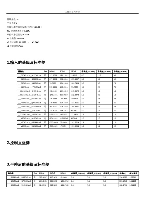
三维自由网平差
- 格式:doc
- 大小:175.00 KB
- 文档页数:5


WGS-84平差坐标在GPS测量中的运用韶关市国土资源信息中心郭建华摘要:本文基于GPS相对定位和坐标转换原理,针对GPS测量中的WGS-84与本地坐标系转换参数的选择进行研究,结合实际测量工作,介绍WGS-84平差坐标在实际测量过程运用,提高工作效率的作业方法。
关键词:WGS-84坐标系,网平差,坐标转换,RTKAbstract: Based on GPS relative positioning and coordinate conversion mechanism for GPS measurements in WGS-84 coordinate system with the local transformation parameters of selection, in combination with the actual measurements, introduced Adjustment WGS-84 coordinates the use of the actual measurement process, improve efficient way of operating.Key words: WGS-84 coordinate system, network adjustment, coordinate transformation,RTK1.引言全球定位系统(GPS)技术的出现,以其高精度、全天候、低成本、高效率等特点被广泛应用到测绘及其他领域,大大的提高了测绘工作的效率,减轻了测绘工作者的外业劳动强度。
由于GPS系统是一个全球性的定位和导航系统,其坐标也是全球性的。
目前GPS测量所使用的协议地球坐标系成果WGS-84世界大地坐标系(World Geodetic System),所有的GPS测量成果都是基于WGS-84坐标系的,包括单点定位的坐标以及相对定位中解算的基线向量。