莆田“9·1”特大暴雨过程短时预报分析
- 格式:pdf
- 大小:1.03 MB
- 文档页数:3
2021年9月3日四川宜宾一次暴雨天气过程分析摘要:利用常规观测资料、卫星资料,从大尺度环流形势、热力和不稳定条件等方面,初步分析了2021年9月3日宜宾市一次暴雨天气过程。
研究结果表明此次大雨是在中高纬两槽一脊环流背景和副高稳定少动的环流形势下,由高原低槽东移、冷空气南下入侵,低空急流和低层切变线等诸多有利条件下发生的一次暴雨天气过程。
孟湾和南海的水汽输送通道良好且在盆地南部有明显的水汽辐合,偏南暖湿气流输送的不稳定能量为暴雨的发生提供了所需的能量条件,此次降雨活动,高度场的预报与实况较为一致,预报效果较好。
关键词:暴雨;强对流;预报天气概况:2021年9月3日21时至9月4日16时,宜宾出现了一次区域性暴雨天气过程,过程大部分地区为小到中雨,叙州区、屏山县、翠屏区出现暴雨局部大暴雨,最大降雨量出现在叙州区龙池164.3毫米。
伴有雷电、局地大风(叙州17m/s)、短时强降雨天气,短时雨强大,最大小时雨屏山县龙华45.6mm,造成了较为严重的灾害。
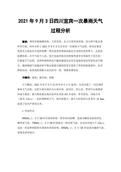
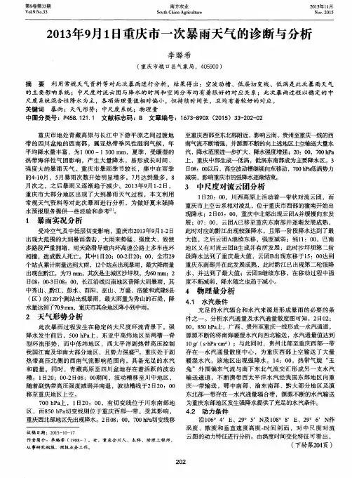
1 环流形式500hPa上,3日08时甘肃到青海一带有西风低槽,盆地为槽前及副高西北侧西南气流,700hPa上,3日08时盆地为一致西南气流,宜宾站风速大于12m/s,急流一直延伸到陕西甘肃境内形成切变;850hPa上,3日08时盆地为偏南气流,盆地北部有辐合。
图1(a) 3日20时综合实况分析图图1(b) 4日08时综合实况分析图如图1(a)所示,20时实况显示:200hPa南亚高压脊线位于川西高原至盆地中部,盆地西北部有分流区;500hPa盆地西北部至川西高原南部有切变,攀西地区至盆地主要受西南气流影响,河套地区、西藏和西北地区均有切变,西北地区有大片24h显著降温区;700hPa盆地北部至西部有较强切变,切变两侧均有急流,湿度条件好;850hPa盆地有倒槽,槽后偏东风较强,除盆地东部外其余地方湿度较好。
如图1(b)所示,08时实况显示:500hPa 川西高原多短波活动,盆地西部受低槽影响;低层盆地中部受低槽影响,700hPa攀西地区有一切变,盆地湿度条件好,有冷空气影响。
一次副高控制下登陆的台风强降雨过程分析范爱芬;娄小芬;彭霞云【摘要】1521号台风“杜鹃”是在5 880 gpm副高控制下,5 920 gpm副高加强西伸过程中,登陆福建莆田沿海的.分析发现副高的加强西伸和低空华北高压的东移,改变了“杜鹃”东部低空急流和水汽辐合的分布,导致水汽辐合和不稳定能量在浙闽东部汇聚,在高空幅散、低空辐合产生的强烈上升运动触发下,产生大暴雨和特大暴雨.“杜鹃”消亡后,925hPa以下的边界层残留低压倒槽顶部东南急流与偏东急流的汇合,使水汽辐合和不稳定能量在浙北东部持续,是该地区继续出现大暴雨的主要原因.“杜鹃”外围东南急流与偏东急流的汇合造成的降雨回波,结构虽没那么致密,但发展更为旺盛,对流性更强,更易造成特强降水,业务预报中,需特别引起注意.%Analyses results show that the strengthening and western extension of subtropical high and the eastern extension of low level North China high changed the vapor transportation and distribution of low level jets and vapor convergence of 1521 Typhoon "Dujuan".Strong vapor convergence and unstable energy accumulated in the eastern parts of Zhejiang and Fujian provinces with the strong ascending motion resulted by the coupling of high level divergence and low level convergence,which caused extraordinary torrential rain.After the withering away of "Dujuan",the low southeastern jet and east jet of its residual low pressure inverted trough top met at the eastern part of north Zhejiang province,which resulted in the continuity of vapor convergence and unstable energy and caused the continuity of extraordinary torrential rain.The meeting of the southeastern jet and east jet of peripheral "Dujuan" caused strong rainfall echo,whosestructure is not so compact,but more convective and more likely to cause extraordinary strong precipitation,which should be paid attention to operational forecast in future.【期刊名称】《海洋预报》【年(卷),期】2017(034)004【总页数】10页(P66-75)【关键词】台风“杜鹃”;副高的加强西伸;低空急流和水汽辐合;降雨回波;大暴雨【作者】范爱芬;娄小芬;彭霞云【作者单位】浙江省气象台,浙江杭州310017;浙江省气象台,浙江杭州310017;浙江省气象台,浙江杭州310017【正文语种】中文【中图分类】P444台风“杜鹃”(Dujuan)于2015年9月23日02时(北京时,下同)在西北太平洋洋面上生成后,向西偏北方向移动,27日05时—28日16时强度最强,达超强台风等级。
doi:10.11676/qxxb2024.20230094气象学报泰山地形对一次副高边缘大暴雨过程影响的观测分析*郑丽娜1 孙继松2ZHENG Lina1 SUN Jisong21. 济南市气象台,济南,2501022. 中国气象科学研究院灾害天气国家重点实验室,北京,1000811. Jinan Meteorological Observatory,Jinan 250102,China2. State Key Laboratory of Severe Weather,Chinese Academy of Meteorological Sciences,Beijing 100081,China2023-06-16收稿,2023-09-04改回.郑丽娜,孙继松. 2024. 泰山地形对一次副高边缘大暴雨过程影响的观测分析. 气象学报,82(2):155-167Zheng Lina, Sun Jisong. 2024. Observational analysis of the topographic effect of Mount Tai on an extreme rainfall event occurring at the edge of the subtropical high. Acta Meteorologica Sinica, 82(2):155-167Abstract Intense observations of precipitation around the Mount Tai during an extreme heavy rain event in autumn 2022 in Shandong province by regional automatic weather stations, radars, wind profilers and satellites are analyzed and possible reasons for the precipitation distribution are explored. The results are as follows:(1) The heavy rain event in Shandong occurred under the background of strong southerly flow in the middle and lower troposphere, and the period of heavy rainfall was concentrated from 23:00 BT 1 October to 02:00 BT the next day. The 100 mm rainfall contour showed a "reverse bow" shape, stretching across the north and west sides of the Mount Tai, with over 170 mm of precipitation at each center. In contrast, rainfall on the south side of the Mount Tai was significantly weaker. (2) Heavy rain belts corresponded to the convergence line-mesoscale vortex system on the ground. The mesoscale vortex on the west side of the Mount Tai formed due to the encounter of the cold flow around the north side of the mountain and the warm flow around the south side. It resulted in a strong precipitation center with single-peak precipitation on the west side of the Mount Tai. The convergence line on the north side of the mountain was sustained and rebuilt, resulting in longer precipitation time and greater accumulated precipitation on the north side of Mount Tai. Hourly precipitation on the north side exhibited a double peak pattern. (3) The two precipitation peaks observed on the north side of the Mount Tai corresponded to the two parallel echo bands of radar reflectivity. The first echo band was located on the north slope of the Mount Tai and remained quasi-stationary for a long time, which corresponded to the ascending branch of the horizontal vorticity circulation on the north side of the Mount Tai. Its formation mechanism is the strong development and maintenance of horizontal vorticity due to the southwesterly low-level jet with strong vertical shear and the northeasterly airflow obstructed by the mountain at low levels in nighttime. The second precipitation echo band corresponded to a cold front cloud system. When it approached the north side of the Mount Tai, it was influenced by the leeward upslope southwesterly low-level airflow, resulting in an increase in the radar reflectivity factor. The corresponding ground wind field was featured by a reconstruction process of the convergence line. (4) On the west side of the Mount Tai, the ground convergence line moved southeastward under the drive of low-level cold air, causing the echo band to gradually evolve into a "reverse bow" shape and the heavy rain band also exhibited a "reverse bow" distribution. The south side of the Mount Tai is located under the subsidence branch of the horizontal vorticity formed by strong vertical shear low-level jet, where precipitation was significantly less compared to that in the north and west sides.Key words Mount Tai range, Circumferential motion, Low-level jet, Horizontal vorticity circulation* 资助课题:2023年中国气象局复盘专项(FPZJ2023—074)、中国气象局气象软科学重点项目(2023ZDIANXM03)。
2022年8月31~9月1日楚雄州强降水天气过程分析摘要:应用NCEP再分析资料,常规观测资料,FY卫星云图,区域自动雨量站资料,通过对环流形势场和物理量场的诊断分析研究了2022年8月31日~9月1日发生在楚雄州地区的一次强降水天气过程。
结果发现:此次天气过程发生在有利的环流背景形势下,由于两高辐合区和副高外围暖湿气流的共同影响,滇中地区的暖湿气流则较为强盛,云顶亮温显示楚雄区域上的系统性对流云系旺盛,造成了这次楚雄州中到大雨局部暴雨单点大暴雨的强降水天气过程。
关键字:楚雄;两高辐合区;强降水;诊断分析引言楚雄地处滇中低纬高原地区,属于亚热带季风区[1],干湿季分明,汛期雨量充沛,降水强度大。
其中影响楚雄州强降水天气过程的天气系统很多,而两高辐合区对楚雄的降水有很大的影响,若配合地面冷锋、低涡或高低空急流系统,则会造成楚雄州大部分地区的强降水过程[2-3]。
本文对8月31日至9月1日的中到大雨局部暴雨单点大暴雨降水过程的降水分布特征、环流形势、物理量场诊断机制[4-6]和卫星云图进行总结归纳分析,这对于在以后的预报工作中对此类强降水的短临预报[7-8]提供一些参考依据。
1 强降水天气实况2022年8月31日08时~9月1日08时.楚雄州出现一次中到大雨局部暴雨单点大暴雨的天气过程,降雨时段主要集中在8月31日20时至9月1日08时,全州210个区域自动雨量站中,出现小雨0.1-9.9mm 86站,中雨10.0-24.9mm59站,大雨25.0-49.9mm 22站,暴雨50.0-99.9mm 8站,大暴雨100.0-250.0mm 4站,最大雨量为大姚县博厚站155.8mm。
2 环流背景形势分析2.1 500hPa 环流场图1a、1b分别为8月31日12时和8月13日18时的500hPa形势图,如图所示:亚洲中高纬地区为两槽一脊形势,呈西高东低的天气形势,有利于冷空气的南下。
31日12时(图1a)中高纬度低压槽的槽线在85-95°E之间,槽底在30-32°N之间,槽后的西北气流引导北方的冷空气南下,影响云南地区,同时还可以看到副高位置偏东西。
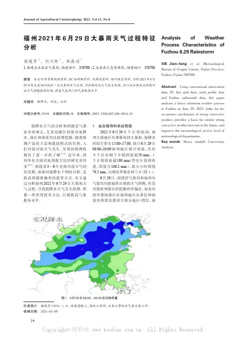
Journal of Agricultural Catastropholgy 2021, Vol 11, No 8作者简介 谢建芳(1976-),女,福建建瓯人,高级工程师,主要从事综合气象业务工作。
收稿日期 2021-03-09Analysis of Weather Process Characteristics of Fuzhou 6.29 Rainstorm XIE Jian-fang et al (Meteorological Bureau of Yongtai County, Fujian Province, Fuzhou, Fujian 350700)Abstract Using conventional observation data, EC fine grid data, wind profile data and Fuzhou radiosonde data, this paper analyzes a heavy rainstorm weather process in Fuzhou on June 29, 2021, looks for the occurrence mechanism of strong convective weather, provides a basis for similar strong convective weather forecast in the future, and improves the meteorological service level of meteorological departments.Key words Heavy rainfall; Convection; Analysis福州2021年6月29日大暴雨天气过程特征分析谢建芳1,何兴林1,林森鸿21.福建省永泰县气象局,福建福州 350700 ;2.永泰县应急管理局,福建福州 350700摘要 本文利用常规观测资料、EC细网格资料、风廓线资料、福州探空资料,分析2021年6月29日发生在福州地区一次大暴雨天气过程,寻找强对流天气发生机理,为以后出现类似的强对流天气预报提供依据,提高气象部门的气象服务水平。

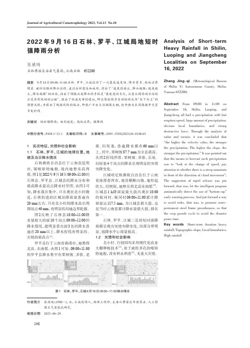
148Journal of Agricultural Catastrophology 2023, Vol.13 No.102022年9月16日石林、罗平、江城局地短时强降雨分析张婧琦石林彝族自治县气象局,云南石林 652200摘要 9月16日09:00~11:00石林、罗平、江城经历了一次暴发速度快、降水量多、局地边界明显、破坏性强的降水过程。
通过分析雷达和地形,得出了“速度值越大,降水越强;坡度越大,降水越强”的结论,指出了预报此类降水的手段是“看速度的变化,注意云团移动方向前方是否有陡峭的山脉”,提出了快速发布的建议,即让智能程序自动检测采用“自下而上”的预警流程;并提出了规避风险的做法,即推广半永久性钢架大棚,使作物生长周期避开灾害多发时间。
关键词 短时强降雨;地形坡度;局地边界;强降雨中图分类号:P458.1+21.1 文献标识码:B 文章编号:2095–3305(2023)10–0148-031 实况特征、灾情和社会影响1.1 石林、罗平、江城的地理位置、地貌及当日降水情况石林彝族自治县位于云南省昆明市,属喀斯特地貌,境内地势东高西 低。
图1是2022年9月16日09:00~11:00的 石林县、罗平县、江城县的降水分布和最高降水量站点降水时序图。
由图1可知,降水落区集中,只出现在北小村附近,石林街道的区域站降雨量普遍在 20 mm 左右,只有北小村的降水高出周围站点40 mm ,有明显的局地边界轮廓。
图2反映了石林县10:00~11:00降水量最大的前10个站点09:00~12:00的降水情况,能明显看出前3名的降水普遍在20 mm 以上,降水折线有明显的、尖锐的最高点[1]。
罗平县位于云南省曲靖市,地势西北高、东南低。
由图1可知,09:00~11:00的罗平县降水集中在栗树坡、多依、老寨、旧屋基,普遍降水都在60 mm 以上,其中,栗树坡87.7 mm 为全县最高。
从图2折线图看,栗树坡、多依、长底、旧屋基4个站点的降水呈现明显的突增突降变化。
《郑州“7.20”极端暴雨天气的基本观测分析》篇一一、引言郑州“7.20”极端暴雨天气是一场罕见的气候现象,其强度、持续时间和影响范围均属罕见。
此次暴雨不仅对当地人民的生命财产安全造成了严重威胁,也对城市基础设施和交通系统带来了巨大的挑战。
本文旨在通过对这次极端暴雨天气的观测分析,为未来类似天气的预报、预警和应对提供科学依据。
二、观测数据与方法本次观测分析主要依据郑州市气象局提供的实时气象数据、卫星云图、雷达回波图等资料。
同时,结合现场实地观测、采访当地居民和政府相关部门,获取了丰富的第一手资料。
在分析方法上,本文主要采用气象学原理、统计学方法和地理信息系统技术,对郑州“7.20”极端暴雨天气的气象要素、空间分布、时间演变等方面进行综合分析。
三、基本观测结果1. 气象要素分析郑州“7.20”极端暴雨天气的降水量达到了历史极值,局部地区降水量超过了往年同期的数十倍。
与此同时,伴随着狂风、雷电等强对流天气,给城市交通和人民生活带来了严重影响。
2. 空间分布特征从空间分布来看,郑州“7.20”极端暴雨天气呈现出明显的地域性特征。
其中,城市中心和部分低洼地区受灾最为严重,而山区和郊区则相对较好。
这主要是由于城市热岛效应和地形地貌等因素的影响。
3. 时间演变过程从时间演变过程来看,郑州“7.20”极端暴雨天气具有持续时间长、强度大、间歇性等特点。
在短时间内,降水量急剧增加,给城市排水系统带来了巨大的压力。
随着时间推移,暴雨逐渐减弱并逐渐停止,但积水却难以迅速消退。
四、成因分析郑州“7.20”极端暴雨天气的成因较为复杂,主要与大气环流、地形地貌、气候变化等因素有关。
其中,大气环流异常是导致此次极端暴雨天气的主要原因之一。
此外,城市热岛效应、地形地貌等因素也加剧了暴雨的强度和影响范围。
同时,全球气候变化导致的极端天气事件频发也为郑州“7.20”极端暴雨天气的发生提供了背景。
五、结论与建议通过对郑州“7.20”极端暴雨天气的观测分析,我们可以得出以下结论:1. 此次极端暴雨天气具有强度大、持续时间长、影响范围广等特点,给当地人民生命财产安全带来了严重威胁。