飞机积冰及其英文译文
- 格式:doc
- 大小:63.50 KB
- 文档页数:6
飞机积冰在飞行中冰是个坏消息。
它破坏了空气的畅通,增加阻力,同时减少了机翼所产生的升力。
结冰对飞机重量的影响与它对气流的干扰相比是微不足道的。
随着油门增加,抬高机头弥补阻力带来的升力损失,攻角增加,造成机翼和机身底部积累更多的冰。
结冰会发生在飞机的所有暴露面,不仅仅是对翅膀,螺旋桨和挡风玻璃,而且天线,通风口,进水口和整流罩都会受到影响。
它通常产生于在飞行中如无发热的地方。
它能够引起天线震动,造成断裂。
在中度至重度的结冰条件下,小型飞机结冰将变得非常容易,因此继续飞行是不可能的。
飞机可能会在比平常更高的速度或者更低的攻角失速。
它使飞机在俯仰和滚动上面失控,并可能无法恢复。
结冰也肯能使汽化器冻结致使发动机停止,或在一个燃油喷射发动机的情况下,挡住了发动机的气源。
冰种和飞行及其影响结构冰这种东西,会凝固在飞机外面。
它被描述为霜,明冰(有时称为釉冰),和混合冰。
雾凇粗糙,外观呈乳白色,一般附着在表面的轮廓。
大部分可除去除冰或防冰设备都可预防。
明(或釉)冰有时是清晰流畅,但通常含有一些气泡,或块状,半透明的外观效果。
积冰越大,越符合机翼形状,其形状往往是由上,下为特点清除冰密集,更难,比雾凇冰更加透明,并且像“牛角”。
一般很难打破。
(冲击力越大的地方,机翼上的结冰就越少;这种形状像是上下两端凸起中间下凹的角。
明冰密度更大,更坚硬比雾凇更透明,通常也很难去除。
)混合冰是雾凇和明冰的组合。
冰可以在机翼表面空气流动扭曲,减少机翼的最大升力,降低了最大升力攻角,影响飞机的操纵品质,在风洞测试中表明,霜,雪,冰(在前沿或机翼上表面),厚度不超过一粗砂纸片可减少百分之三十升力和增加阻力高达百分之四十。
较大的附着,更会减少升力,可以增加百分之八十以上的阻力。
即使飞机进入结冰条件下飞行配备除冰系统,未受保护区域依然会有冰的积累。
美国航天局研究显示,近百分之三十的阻力依然存在即使已经对飞机的主要表面进行清理。
非保护表面可能包括天线,襟翼铰链,控制喇叭,机身前部区域,挡风玻璃刮水器,机翼支柱,固定起落架等。
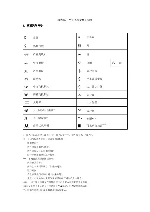
模式SN 用于飞行文件的符号1.重要天气符号雷暴毛毛雨热带气旋雨严重飑线* 雪中度颠簸阵雨雹严重颠簸大片吹雪山地波严重沙或尘霾中度飞机积冰大片沙(尘)暴严重飞机积冰大片霾大片雾大片轻雾大气中的放射性物质**大片烟火山喷发*** 冻雨***山地状况不明可见火山灰云****** 在为飞行高度层100以下飞行的飞行文件中,这个符号指“飑线”。
** 下列情报涉及的符号应该在图边标明:放射物符号;意外事故点的经/纬度;意外事故发生的日期和时间;进一步情报的核对航行通告。
*** 下列情报应该在图边标明:火山喷发符号;火山名字和国际编号(如果知道);经/纬度;首次喷发的日期和时间(如果知道);关于火山灰的核对重要气象情报和航行通告或火山通告。
**** 这个符号不涉及在很低温度下由于降水而引起的飞机积冰。
*****可见的火山云符号仅仅适用于VAG模式,对SIGWX图不适用。
注:每幅图例的预期现象的底顶间高度指示。
2.锋面、辐合带和其他的符号地面冷锋最大风的位置、速度和高度层地面暖锋幅合线地面锢囚锋零度等温度层高度地面准静止锋热带辐合带对流层顶高点海面状况对流层顶低点海面温度对流层顶高度大范围的强地面风风矢表明急流的最大风和所在的飞行高度层。
用双横线标明大于或等于20海里/小时的风速变化和3000英尺(或更小,如果可行)的飞行高度层的显著变化。
在此例中,双横线处风速是225公里/小时(120公里/小时)。
粗线描绘预报风速为150公里/小时(80公里/小时)的急流轴的起始点和终止点。
* 该符号指出大范围地面风速超过60公里/小时(30海里/小时)。
3.用于描述云的缩写3.1 云状CI一卷云CS一卷层云AS一高层云SC一层积云CU一积云CC一卷积云AC一高积云NS一雨层云ST一层云CB一积雨云3.2 云量除CB以外的云:SKC = 碧空(0/8) FEW =少云(1/8-2/8) SCT = 疏云(3/8-4/8)BKN = 多云(5/8-7/8) 0VC = 阴天(8/8)只限CB:ISOL = 个别(孤立的)CBOCNL = 完全分离的CBFRQ = 很少或不分离的CBEMBD = 隐嵌在其他云层中或隐嵌在霾里的CB3.3 高度在SWH和SWM图上的高度都用飞行高度层表示,当用XXX表示底或顶的高度时,底高或顶高都在SWL图的气层以外。
翻译1 英文原文TURBULENCEEveryone who flies encounters turbulence at some time or other . A turbulent atmosphere as one in which air currents range from rather mild eddies to strong currents of relatively large dimensions. As an aircraft moves through these currents, it undergoes changing accelerations which jostle it from its smooth flight path. This jostling is turbulence. Turbulence ranges from bumpiness which can annoy crew and passengers to severe jolts which can structurally damage the aircraft or injure its passengers.Aircraft reaction to turbulence varies with the difference in wind speed in adjacent currents, size of the aircraft, wing loading, airspeed, and aircraft attitude. When an aircraft travels rapidly from one current to another, it undergoes abrupt changes in acceleration. Obviously , if the aircraft moves more slowly, the changes in acceleration would be more gradual. The first rule in flying turbulence is to reduce airspeed. Your aircraft manual most likely lists recommended airspeed for penetrating turbulence.Knowing where to expect turbulence helps a pilot avoid or minimize turbulence discomfort and hazards. The main causes of turbulence are (1) convective currents, (2) mountain wave, and (3) wind shear. Turbulence also occurs in the wake of moving aircraft whenever the airfoils exert lift—wake turbulence. Any combination of causes may occur at one time.CONVECTIVE CURRENTSConvective currents are a common cause of turbulence, especially at low altitudes. These currents are localized vertical air movements, both ascending and descending. For every rising current, there is a compensating downward current. The downward currents frequently occur over broader areas than do the upward currents, and therefore, they have a slower vertical speed than dothe rising currents.Convective currents are most active on warm summer afternoons when winds are light. Heated air at the surface creates a shallow, unstable layer, and the warm air is forced upward. Convection increases in strength and to greater heights as surface heating increases. Barren surfaces such as sandy or rocky wastelands and plowed fields become hotter than open water or ground covered by vegetation. Thus, air at and near the surface strength of convective currents can vary considerably within short distances.When cold air moves over a warm surface, it becomes unstable in lower levels. Convective currents extend several thousand feet above the surface resulting in rough, choppy turbulence when flying in the cold air. This condition often occurs in any season after the passage of a cold front.Turbulence on approach can cause abrupt changes in airspeed and may even result in a stall at a dangerously low altitude. To prevent the danger, increase airspeed slightly over normal approach speed. This procedure may appear to conflict with the rule of reducing airspeed for turbulence penetration; but remember, the approach speed for your aircraft is well below the recommended turbulence penetration speed.As air moves upward, it cools by expansion. A convective current continues upward until it reaches a level where its temperature cools to the same as that of the surrounding air. If it cools to saturation, a cloud forms. Billowy fair weather cumulus clouds, usually seen on sunny afternoons, are signposts in the sky indicating convective turbulence. The cloud top usually marks the approximate upper limit of the convective current. A pilot can expect to encounter turbulence beneath or in the clouds, while above the clouds, air generally is smooth.MOUNTAIN WAVEWhen stable air crosses a mountain barrier, the turbulent situation is somewhat reversed. Air flowing up the windward side is relatively smooth. Wind flow across the barrier is laminar—that is, it tends to flow in layers. The barrier may set up waves in these layers much as waves develop on a disturbed water surface. The waves remain nearly stationary while the wind blows rapidly throughthem. The wave pattern is a “standing” or “mountain” wave, so named because it remains essentially stationary and is associated with the mountain. The wave pattern may extend 100 miles or more downwind from the barrier.Wave crests extend well above the highest mountains, sometimes into the lower stratosphere. Under each wave crest is a rotary circulation, the “rotor” forms below the elevation of the mountain peaks. Turbulence can be violent in the overturning rotor. Updrafts and downdrafts in the waves can also create violent turbulence.When planning a flight over mountainous terrain, gather as much preflight information as possible on cloud reports, wind direction, wind speed, and stability of air. Satellites often help locate mountain waves, but adequate information may not always be available, so remain alert for signposts in the sky. What should you look for both during preflight planning and during your in flight observations?Wind at mountain top level in excess of 25 knots suggests some turbulence. Wind in excess of 40 knots across a mountain barrier dictates caution. Stratified clouds mean stable air. Standing lenticular and rotor clouds suggest a mountain wave; expect turbulence many miles to the lee of mountains and relative smooth flight on the windward side. Convective clouds on the windward the mountain.When approaching mountains from the leeward side during strong winds, you’d better begin your climb well away from the mountain—100 miles in mountain wave .Climb to an altitude 3,000 to 5,000 feet above mountain tops before attempting to cross. The best procedure is to approach a ridge at a 45°angle to enable a rapid retreat to calmer air. If unable to make good on your first attempt and you have higher altitude capabilities, you may back off and make another attempt at higher altitude. Sometimes you may have to choose between turning back or detouring the area.Flying mountain passes and valleys is not a safe procedure during high winds. The mountains funnel the wind into passes and valleys thus increasing wind speed and intensifying turbulence. If winds at mountain top level are strong, go high, or go around. Surface wind may be relatively calm in a valley surrounded by mountains when wind aloft is strong.. If taking off in the valley, climb above mountain clearance from the mountains sufficient to allow recovery if caught in a downdraft.WIND SHEARWind shear generates eddies between two wind currents of differing velocities. The differences may be in wind speed, wind direction, or in both. Wind shear may be associated with either a wind shift or a wind speed gradient at any level in the atmosphere. Three conditions are of special interest—(1) wind shear with a low-level temperature inversion, (2) wind shear in a frontal zone, and (3) clear air turbulence at high levels associated with a jet stream or strong circulation.WIND SHEAR WITH A LOW-LEVEL TEMPERATURE INVERSIONWhen surface wind is calm or very light, takeoff or landing can be in any direction. Takeoff may be in the direction of the wind above the inversion. If so, the aircraft encounters a sudden tailwind and a corresponding loss of airspeed when climbing through the inversion. Stall is possible. If approach is into the wind above the inversion, the headwind is suddenly lost when descending through the inversion. Again, a sudden loss in airspeed may induce a stall.A temperature inversion forms near the surface on a clear night with calm or light surface wind. When taking off or landing in calm wind under clear skies within a few hours before or after sunrise, be prepared for a temperature inversion near the ground. You can be relatively certain of a shear zone in the inversion if you know the wind as 2000 to 4000 feet is 25 knots or more. Allow a margin of airspeed above normal climb or approach speed to alleviate danger of stall in event of turbulence or sudden change in wind velocity.WIND SHEAR IN A FRONTAL ZONEA front can contain many hazards. However, a front can be between two dry stable airmasses and can be devoid of clouds. Even so, wind changes abruptly in the frontal zone and can inducewind shear turbulence. The degree of turbulence depends on the magnitude of the wind shear. When turbulence in expected in a frontal zone, follow turbulence penetration procedures recommended in your aircraft manual.CLEAR AIR TURBULENCEClear air turbulence implies turbulence devoid of clouds. However, we commonly reserve the term for high level wind shear turbulence, even when in cirrus clouds. A preferred location of CAT is in an upper trough on the cold side of the jet stream. Another frequent CAT location is along the jet stream north and northeast of a rapidly deepening surface low. Even clear air turbulence can destroyed the aircraft so easily, it is every pilots’ obligation to report the CAT when encountered, and pilot when preflight must check the weather forecast, and report to make sure there is no CAT in the flight path.WAKE TURBULENCEAn aircraft receives its lift by accelerating a mass of air downward. Thus, whenever the wings are providing lift, air is forced downward under the wings generating rotary motions or vortices off the wing tips. When the landing gear bears the entire weight of the aircraft, no wing tip vortices develop. But the instant the pilot “hauls back” on the controls, these vortices begin and spread downward and outward from the flight path. They also drift with the wind. Strength of the vortices is proportional to the weight of the aircraft as well as other factors. Therefore, wake turbulence is more intense behind large, transport category aircraft than behind small aircraft. Generally, it is a problem only when following the larger aircraft.The turbulence persists several minutes and may linger after the aircraft is out of sight. At controlled airports, the controller generally warns pilots in the vicinity of possible wake turbulence. When left to your own resources, you could use a few pointers. Most jets when taking off lift the nose wheel about midpoint in the takeoff roll; therefore, vortices begin about the middle of the takeoff roll. Vortices behind propeller aircraft begin only a short distance behind lift-off. Followinga landing of either type of aircraft, vortices end at about the point where the nose wheel touches down. Avoid flying through these vortices. More specifically, when using the same runway as a heavier aircraft:(1)if landing behind another aircraft, keep your approach above his approach and keep youtouchdown beyond the point where his nose wheel touched the runway;(2)if landing behind a departing aircraft, land only if you can complete your landing roll beforereaching the midpoint of his takeoff roll;(3)if departing behind another departing aircraft, take off only if you can become airbornebefore reaching the midpoint of his takeoff roll and only if you can climb fast enough to stay above his flight path;(4)If departing behind a landing aircraft, don’t un less you can taxi onto the runway beyond theat which his nose wheel touched down and have sufficient runway left for safe takeoff. The foregoing procedures are elementary. The problem of wake turbulence is more operational than meteorological. The FAA issues periodic advisory circulars of operational problems. If you plan to operate out of airports used routinely by air carriers, we highly recommend you read the latest advisory circulars on wake turbulence. Titles of there circulars are listed in the FAA “Advisory Circular Checkl ist and Status of Regulations.”ICINGAircraft icing is one of the major weather hazards to aviation. Icing is a cumulative hazard. It reduces aircraft efficiency by increasing weight, reducing lift, decreasing thrust, and increasing drag. As shown in figure 1, each effect tends to either slow the aircraft or force it downward. Icing also seriously impairs aircraft engine performance. Other icing effects include false indications on flight instruments, loss of radio communications, and loss of operation of control surfaces, brakes, and landing gear.Figure 1. Effects of structural icing.In this article we discuss the principles of structural, induction system, and instrument icing, and other factors on icing. Although ground icing and frost are structural icing, we discuss them separately because of their different effect on an aircraft. And we wind up the chapter with a few operational pointers.STRUCTURAL ICINGTwo conditions are necessary for structural icing in flight: (1) the aircraft must be flying through visible water such as rain or cloud droplets, and (2) temperature at the point where the moisture strikes the aircraft must be 0° ; C or colder. Aerodynamic cooling can lower temperature of an airfoil to 0° C even though the ambient temperature is a few degrees warmer.Supercooled water increases the rate of icing and is essential to rapid accretion. Supercooled water is in an unstable liquid state; when an aircraft strikes a supercooled drop, part of the drop freezes instantaneously. The latent heat of fusion released by the freezing portion raises the temperature of the remaining portion to the melting point. Aerodynamic effects may cause theremaining portion to freeze. The way in which the remaining portion freezes determines the type of icing. The types of structural icing are clear, rime, and a mixture of the two. Each type has its identifying features.CLEAR ICEClear ice forms when after initial impact, the remaining liquid portion of the drop flows out over the aircraft surface gradually freezing as a smooth sheet of solid ice. This type forms when drops are large as in rain or in cumuliform clouds. Figure 2 illustrates ice on the cross section of an airfoil, clear ice shown at the top.Figure 2. Clear, rime, and mixed icing on airfoilsRIME ICERime ice forms when drops are small, such as those in stratified clouds or light drizzle. The liquid portion remaining after initial impact freezes rapidly before the drop has time to spread over the aircraft surface. The small frozen droplets trap air between them giving the ice a white appearance as shown at the center of figure 2.Rime ice is lighter in weight than clear ice and its weight is of little significance. However, its irregular shape and rough surface make it very effective in decreasing aerodynamic efficiency of airfoils, thus reducing lift and increasing drag. Rime ice is brittle and more easily removed than clear ice.MIXED CLEAR AND RIME ICINGMixed ice forms when drops vary in size or when liquid drops are intermingled with snow or ice particles. It can form rapidly. Ice particles become imbedded in clear ice, building a very rough accumulation sometimes in a mushroom shape on leading edges as shown at the bottom of figure 2.INDUCTION ICINGIce frequently forms in the air intake of an engine robbing the engine of air to support combustion. This type icing occurs with both piston and jet engines, and almost everyone in the aviation community is familiar with carburetor icing. The downward moving piston in a piston engine or the compressor in a jet engine forms a partial vacuum in the intake. Adiabatic expansion in the partial vacuum cools the air. Ice forms when the temperature drops below freezing and sufficient moisture is present for sublimation. In piston engines, fuel evaporation produces additional cooling. Induction icing always lowers engine performance and can even reduce intake flow below that necessary for the engine to operate. Figure 3 illustrates carburetor icing.Figure 3. Carburetor icing. Expansional cooling of air and vaporization of fuel can induce freezing and cause ice to clog the carburetor intake.Induction icing potential varies greatly among different aircraft and occurs under a wide range of meteorological conditions. It is primarily an engineering and operating problem rather than meteorological.INSTRUMENT ICINGIcing of the pitot tube as seen in figure 4 reduces ram air pressure on the airspeed indicator and renders the instrument unreliable. Most modern aircraft also have outside static pressure port as part of the pitot-static system. Icing of the static pressure port reduces reliability of all instruments on the system - the airspeed, rate-of-climb, and altimeter.Figure 4. Internal pitot tube icing. It renders airspeed indicator unreliable.Ice forming on the radio antenna distorts its shape, increases drag, and imposes vibrations that may result in failure in the communications system of the aircraft. The severity of this icing depends upon the shape, location, and orientation of the antenna.OTHER FACTORS IN ICINGIn addition to the above, other factors also enter into icing. Some of the more important ones are discussed below.FRONTSAtmospheric circulation is the movement of air around the surface of the Earth. It is caused by uneven heating of the Earth’s surface and upsets the equilibrium of the atmosphere, creating changes in air movement and atmospheric pressure. Because the Earth has a curved surface that rotates on a tilted axis while orbiting the sun, the equatorial regions of the Earth receive a greater amount of heat from the sun than the polar regions. The amount of sun that heats the Earth depends upon the time of day, time of year, and the latitude of the specific region. All of these factors affect the length of time and the angle at which sunlight strikes the surface. In general circulation theory, areas of low pressure exist over the equatorial regions, and areas of high pressure exist over the polar regions due to a difference in temperature. Solar heating causes air to become less dense and rise in equatorial areas. The resulting low pressure allows the high-pressure air at the poles to flow along the planet’s surface toward the equator. As the warm air flows toward the poles, it cools, becoming more dense, and sinks back toward the surface. This pattern of air circulation is correct in theory; however, the circulation of air is modified by several forces, most importantly the rotation of the Earth. The force created by the rotation of the Earth is known as Coriolis force. This force is not perceptible to us as we walk around because we move so slowly and travel relatively short distances compared to the size and rotation rate of the Earth. However, it does significantly affect bodies that move over great distances, such as anair mass or body of water. The Coriolis force deflects air to the right in the Northern Hemisphere, causing it to follow a curved path instead of a straight line. The amount of deflection differs depending on the latitude. It is greatest at the poles, and diminishes to zero at the equator. The magnitude of Coriolis force also differs with the speed of the moving body—the faster the speed, the greater the deviation. In the Northern Hemisphere, the rotation of the Earth deflects moving air to the right and changes the general circulation pattern of the air. The speed of the Earth’s rotation causes the general flow to break up into three distinct cells in each hemisphere. [Figure 10-9] In the Northern Hemisphere, the warm air at the equator rises upward from the surface, travels northward, and is deflected eastward by the rotation of the Earth. By the time it has traveled one-third of the distance from the equator to the North Pole, it is no longer moving northward, but eastward. This air cools and sinks in a belt-like area at about 30°latitude, creating an area of high pressure as it sinks toward the surface. Then it flows southward along the surface back toward the equator. Coriolis force bends the flow to the right, thus creating the northeasterly trade winds that prevail from 30°latitude to the equator. Similar forces create circulation cells that encircle the Earth between 30° and 60° latitude, and between 60° and the poles. This circulation pattern results in the prevailing westerly winds in the conterminous United States. Circulation patterns are further complicated by seasonal changes, differences between the surfaces of continents and oceans, and other factors. Frictional forces caused by the topography of the Earth’s surface modify the movement of the air in the atmosphere. Within 2,000 feet of the ground, the friction between the surface and the atmosphere slows the moving air. The wind is diverted from its path because the frictional force reduces the Coriolis force. This is why the wind direction at the surface varies somewhat from the wind direction just a few thousand feet above the Earth.Air flows from areas of high pressure into those of low pressure because air always seeks out lower pressure. In the Northern Hemisphere, this flow of air from areas of high to low pressure is deflected to the right; producing a clockwise circulation around an area of high pressure. This is also known as anti-cyclonic circulation. The opposite is true of low-pressure areas; the air flows toward a low and is deflected to create a counter-clockwise or cyclonic circulation. High-pressure systems are generally areas of dry, stable, descending air. Good weather is typically associated with high-pressure systems for this reason. Conversely, air flows into a low-pressure area to replace rising air. This air tends to be unstable, and usually brings increasing cloudiness and precipitation. Thus, bad weather is commonly associated with areas of low pressure.A condition favorable for rapid accumulation of clear icing is freezing rain below a frontal surface. Rain forms above the frontal surface at temperatures warmer than freezing. Subsequently, it falls through air at temperatures below freezing and becomes supercooled. The supercooled drops freeze on impact with an aircraft surface. Figure 5 diagrams this type of icing. It may occur with either a warm front (top) or a cold front. The icing can be critical because of the large amount of supercooled water. Icing can also become serious in cumulonimbus clouds along a surface cold front, along a squall line, or embedded in the cloud shield of a warm front.Figure 5. Freezing rain with a warm front (top) and a cold front (bottom). Rainfall through warm air aloft into subfreezing cold air near the ground. The rain becomes supercooled and freezes on impact.TERRAINAir blowing upslope is cooled adiabatically. When the air is cooled below the freezing point, the water becomes supercooled. In stable air blowing up a gradual slope, the cloud drops generally remain comparatively small since larger drops fall out as rain. Ice accumulation is rather slow and you should have ample time to get out of it before the accumulation becomes extremely dangerous. When air is unstable, convective clouds develop a more serious hazard as described in "Icing and Cloud Types."Icing is more probable and more hazardous in mountainous regions than over other terrain. Mountain ranges cause rapid upward air motions on the windward side, and these vertical currentssupport large water drops. The movement of a frontal system across a mountain range often combines the normal frontal lift with the upslope effect of the mountains to create extremely hazardous icing zones.Each mountainous region has preferred areas of icing depending upon the orientation of mountain ranges to the wind flow. The most dangerous icing takes place above the crests and to the windward side of the ridges. This zone usually extends about 5,000 feet above the tops of the mountains; but when clouds are cumuliform, the zone may extend much higher.SEASONSIcing may occur during any season of the year; but in temperate climates such as cover most of the contiguous United States, icing is more frequent in winter. The freezing level is nearer the ground in winter than in summer leaving a smaller low level layer of airspace free of icing conditions. Cyclonic storms also are more frequent in winter, and the resulting cloud systems are more extensive. Polar regions have the most dangerous icing conditions in spring and fall. During the winter the air is normally too cold in the polar regions to contain heavy concentrations of moisture necessary for icing, and most cloud systems are stratiform and are composed of ice crystals.GROUND ICINGFrost, ice pellets, frozen rain, or snow may accumulate on parked aircraft. You should remove all ice prior to takeoff, for it reduces flying efficiency of the aircraft. Water blown by propellers or splashed by wheels of an airplane as it taxis or runs through pools of water or mud may result in serious aircraft icing. Ice may form in wheel wells, brake mechanisms, flap hinges, etc, and prevent proper operation of these parts. Ice on runways and taxiways create traction and braking problems.中文翻译颠簸激流每一个飞行员都有可能遇到颠簸,当一个颠簸的气流运动(包括涡旋和大的相对气流),飞机飞过这些气流时,它改变了飞机的速度,从而使飞机偏离了它平滑的航道。

浅析飞机积冰的原因及防冰策略摘要:飞机积冰会严重影响飞机的性能并危及到飞行的安全,现代飞机都装有先进的防冰系统,该文主要对形成积冰的原因并主要探讨了从飞行中和起飞前地面除、防冰两个方面,说明了积冰对飞行的影响以及正确的防范措施说明积冰的处置和除、防冰的方法。
关键词:飞机积冰飞行安全防范措施Reason analysis of aircraft icing and ice prevention strategiesAbstract:Aircraft Icing will seriously affect the performance of aircraft and endanger the flight safety, the modern aircraft are equipped with anti icing system,this paper focuses on the reasons for the formation of icing and mainly discusses from two aspects of flight and flight before the ground except, anti icing, illustrates the effect of ice accretion on flight and preventive measures to correct description of the disposal and method of removing ice, ice.Key words:Aircraft icing Flight safety Preventive measures.给生活带来乐趣的雪和冰,对于飞机的运营来说,却变成了一个无形的杀手。
冰和雪极大的威胁着飞机的安全运行,跑道道面上结冰和大量积雪就是其中之一。
冰和雪会减少刹车效果、降低加速性能,给飞机起降性能造成很大影响,这一点早就被人们所认识并一直在采取对策。
飞机专业术语(英汉对照)1、theairframe机身,结构2、Thefront(fore)part前部3、Therear(aft)part后部4、port左旋(舵)5、starboard右旋(舵)6、theinboardengineorinboards内侧发动机7、theoutboardengineoroutboards外侧发动机8、thenose机头9、thebelly腹部10、theskin蒙皮11、thewindscreenorwindshield风挡12、thewing机翼13、thetrailingedge机翼后缘14、theleadingedge机翼前缘15、thewingtip翼尖16、thecontrolsurface操纵面17、ailerons副翼18、flaps(inboardflap,outboardflap,leadingedgeflaps)襟翼(内侧襟翼,外侧襟翼,前缘缝翼)19、spoilers(inboard\outboardspoiler)(spoilerdown\up)阻力板,扰流板(内、外侧扰流板)(扰流板放下、打开)20、slats缝翼21、elevators(elevatorcontroltab)升降舵(升降舵操纵片)22、rudder(ruddercontroltab)方向舵(方向舵操纵片)23、flapangle 襟翼角24、flapsetting襟翼调整25、thefullflapposition全襟翼位置26、aflaplesslanding无襟翼着陆27、thelandinggear起落架28、stabilizer安定面29、thenosewheel前轮30、gearlocked起落架锁定31、thewheelwell起落架舱32、thewheeldoor起落架舱门33、atyre轮胎34、toburst爆破35、adeflatedtyre放了气的轮胎36、aflattyre走了气的轮胎37、apuncture轮胎被扎破38、toextendtheflaps(toretracttheflaps)放下襟翼(收上襟翼)39、gearextention(gearretraction)起落架放下(起落架收上)40、Thegearisjammed.起落架被卡死。
飞行艰难的词汇
飞行中可能会遇到的艰难情况有很多,以下是一些与飞行艰难相关的词汇:
1. 湍流(Turbulence):飞行中遇到的颠簸,通常由气流的不规则运动引起。
2. 结冰(Icing):飞机表面或机翼上形成的冰层,可能影响飞机的性能和操控性。
3. 低气压(Low Pressure):飞行高度低导致的外部气压下降,可能引起飞行员和乘客的不适。
4. 高空急流(Jet Stream):高空中的强风流,可能对飞机的航迹和燃油效率产生影响。
5. 雷暴(Thunderstorm):强雷暴天气,包括闪电、雷鸣和强降水,对飞行构成严重威胁。
6. 能见度低(Visibility):由于雾、霾或其他天气条件导致飞行员能见度降低。
7. 飞行高度限制(Flight Level Restrictions):由于天气或其他原因,飞机可能需要限制飞行高度。
8. 空中交通拥堵(Air Traffic Congestion):在繁忙的空域中,飞机需要等待 clearance 才能起飞或降落。
9. 引擎故障(Engine Failure):飞机引擎在飞行中出现故障,需要紧急处理。
10. 恶劣天气(Adverse Weather):包括暴风雨、沙尘暴、极
端温度等对飞行不利的天气条件。
这些词汇描述了飞行中可能遇到的挑战和风险,飞行员和航空公司的运营人员需要密切关注天气情况和飞机性能,以确保乘客和机组人员的安全。
1 飞机及其主要部件 AIRCRAFT AND MAIN COMPONENTS飞机 aircraft, airplane1.1飞机类型 AIRCRAFT TYPE民用飞机 civil aircraft干线机 trunk aircraft, trunkliners支线机 regional aircraft, commuter商用飞机 commercial aircraft客货两用机 combination aircraft旅客机 passenger aircraft运输机 transport aircraft宽体飞机 wide fuselage aircraft窄机身飞机 narrow-bodied aircraft大型运输机 large transport aircraft货机 cargo aircraft, airfreighter, freight aircraft公务机/行政勤务飞机 business/executive aircraft, administrative aircraft 公务喷气机 business jet aircraft, corporate jet aircraft通用飞机 general-purpose aircraft私人飞机 private owner airplane适航飞机 airworthy aircraft全天候飞机 all-weather aircraft后掠翼飞机 swept back wing airplane喷气式飞机 jet airplane燃气涡轮式飞机 turbine-engine aircraft涡轮风扇式飞机 turbofan aircraft涡轮喷气式飞机 turbojet airplane 双喷气发动机飞机 twin-jet aircraft 亚音速飞机 subsonic aircraft 中程飞机 medium-range aircraft 中短程飞机 short/medium aircraft 远程飞机 long-distance aircraft 半硬壳式飞机 semimonocoque aircraft 前(后)三点飞机 aircraft with nose (tail) wheel 原型机,样机 prototype aircraft, mockup 试验型飞机 development aircraft 基本型飞机 basic aircraft 改型飞机 modified aircraft 批生产飞机mass-produced aircraft1.2 飞机主要部件及其结构AIRCRAFT MAIN COMPONENTS AND STRUCTURAL MEMBERS1.2.1 机身 FUSELAGE机体 airframe, body 机头 nose 机身 fuselage 前机身 forward fuselage 中机身 mid fuselage 中后机身 mid-aft fuselage 后机身 aft fuselage 机身下部 lower fuselage 机身中上部 mid-upper fuselage 机身上部 upper fuselage 增压机身 pressurized fuselage 机身结构 fuselage structure 机体结构 airframe structure 半硬壳式机身 semimonocoque fuselage 半硬壳式结构 semimonocoque structure 主要结构primary structure次要结构,辅助结构 secondary structure,auxiliary structure 基本结构 basic structure复合材料结构 composite material structure 胶结蜂窝结构 honeycomb bonded structure金属胶结结构 metal-to-metal adhesive bonded structure 加强结构 reinforced structure 梁肋结构 spar-and rib structure 机身蒙皮 fuselage skin隔框 bulkhead (BHD), frame 机身隔框 fuselage frame 圆形隔框circumferential frame 机身与机翼对接隔框 fuselage-wing frame 翼梁固定隔框 spar frame 前梁固定隔框 front spar frame 后梁固定隔框 rear spar frame 气密隔框 pressure bulkhead 防火隔板(墙) fire bulkhead 机身桁梁(大梁) longeron 横梁 transverse beam 纵梁 longitudinal beam 长桁 stringer,longeron 角形桁条 angle stringer “Z”型桁条 "Z"section stringer “Π”型桁条"hat-section" stringer加强桁条 heavy stringer 龙骨梁 keel beam 龙骨 keel 地板 floor panel 地板梁 floor beam 座椅滑轨 seat track 气密地板pressure floor 整流片(带,包皮)fillet机身机翼接合整流带(翼根整流带) fuselage-to-wing fillet, wing-root fillet 整流罩 fairing机身整流罩 fuselage fairing机身机翼整流罩 fuselage-to-fairing雷达天线罩 radome天线整流罩 antenna fairing搭接板 splice机身搭接板 fuselage splice纵向搭接板 longitudinal splice长桁搭接板 stringer splice加强板(双搭接板) double splice机身站位 station (STA) 站位线 station line机身横截面 fuselage cross section水平线 water line (WL)纵剖线(横向站位线) buttock line (BL)中心线 center line (CL)机身气密包线 fuselage pressure envelope分离面 break工艺分离面 production break, manufacturing break主舱地板 main deck 货舱地板 cargo deck驾驶舱地板 flight compartment floor纵向加强件 intercostal转折梁 crease beam尾锥 tailcone化纤蒙皮 chemical-milled skin 1.2.2机翼 WING ·机翼类型 WING TYPE基本翼 basic wing 中央翼 center wing 中外翼(翼)inboard wing外翼 outboard wing 翼尖 wing tip上单翼 upper-monowing 下单翼 lower-monowing上反角机翼 anhedral wing, positive dihedral wing 下反角机翼 negative dihedral wing 带盒形梁的机翼 box-spar wing 双梁式机翼 double-spar wing 整体油箱机翼 fuel-tight wing 有襟翼的机翼 flapped wing 后掠机翼 sweptback wing 前缘开缝机翼 nose-slot wing 翼梢小翼 winglets·机翼主要结构 PRIMARY WING STRUCTURE 前缘 leading edge 后缘 trailing edge 翼尖整流罩 wing-tip fairing 翼根整流带 wing-root fillet 翼根整流罩 wing-root fairing 翼梁 wing spar 盒形翼梁 box spar 前梁 front spar 后梁 rear spar 纵墙(假梁) false spar 副翼翼梁 aileron spar辅助梁 secondary spar, auxiliary spar 展向梁 spanwise beam腹板式翼梁 plated-web spar, web-type spar 整体式翼梁 one-piece spar 后缘翼梁 trailing edge beam起落架支撑梁landing gear (support) beam 机翼辅助梁(机翼纵墙) wing web (W/W) beam 翼盒 wing box 中央翼盒 center wing box 扭力盒 torsion box 机翼整体油箱 integral fuel tank 翼肋 wing rib 油箱端肋 tank end rib 加强肋 reinforced rib梁间加强肋intercostal,reinforced rib整体肋 one-piece rib 腹板 web 缘条 chord,flange 支柱,加强件 stiffener 长桁 stringer上长桁 upper stringer ER 下长桁 lower stringer 机翼蒙皮 wing skin 蒙皮壁板 skin panel 铝合金蒙皮 alumium skin 蜂窝结构蒙皮 honeycomb skin 双层蒙皮 double skin 轻合金蒙皮 light-alloy skin 抗拉蒙皮 tension skin 加强蒙皮 reinforced skin 蒙皮 inner skin 外蒙皮 outer skin 上蒙皮 upper skin 下蒙皮 lower skin 翼剖面(翼型) airfoil襟翼滑轨整流罩 flap track fairing 根部(三叉)接头 terminal fitting ·襟翼 WING FLAP 侧襟翼 inboard flaps 外侧襟翼 outer flaps 前缘襟翼 leading-edge flap 后缘襟翼 trailing-edge flap襟翼滑轨安装接头 flap track attachment fitting ·缝翼 SLAT前缘缝翼 leading-edge slat 可操纵缝翼 movable slat ·副翼 AILERON 扰流板 spoiler 减速板 airbrake 减升板 lift dumper 调整片 tab, adjustable tab 副翼调整片 aileron trim tab 铰头 hinge fitting 作动器接头 actuator fitting 1.2.3 尾翼TAIL, EMPENNAGE安定面 STABILIZER水平安定面 horizontal stabilizer水平尾翼 horizontal tail垂直安定面 vertical stabilizer垂直尾翼 vertical tail,vertical fin全动垂直尾翼 all-movable vertical tail,all-movable fin操纵面,舵面 control surface舵面锁 gust lock, control lock方向舵 rudder升降舵 elevator背鳍 dorsal fin翼尖 wing tip补偿装置 COMPENSATOR迎角补偿器 angle-of-attack compensator配平装置 trimmer调整片 trim tab, adjustable tab升降舵调整片 elevator trim tab方向舵调整片 rudder trim tab固定调整片 fixed trim tab操纵调整片 control tab方向舵操纵装置 rudder control unit偏航阻尼器 yaw damper安定面结构 STABILIZER STRUCTURE前缘 leading edge (LE) 固定前缘 fixed leading edge 可卸前缘 removable leading edge 前梁 front spar 后梁 rear spar 扭力盒 torque box 长桁 stringer 肋rib安定面配平致动螺杆 stabilizer trim jack screw配重 balance weight, counter balance, mass balance 整体壁板 intergral panel 中梁 middle spar 中央盒板 center section 外伸段 outer section 1.2.4 舱门 DOORS ·舱门 DOORS 登机门entry door旅客门 passenger door 旅客登机门 passenger entry door 驾驶舱门 crew door 货舱门 cargo door行舱门 baggage door, luggage door 应急门(出口) emergency door (exit) 服务舱门 service door 检修门 access door 厨房门 galley door 盥洗室门 lavatory door 登机梯门 airstair door 电气设备舱门 electrical door 电子设备舱门 electronics door 起落架舱门 landing gear door驾驶舱应急出口 escape hatch, overhead hatch 辅助动力装置舱门 APU(Auxiliary Power Unit) access door 电子/电气舱门 E&E compartment door 冲压空气涡轮舱门 RAT compartment door 前起落架舱门 nose landing gear door 主起落架舱门 main landing gear door ·门结构 DOOR STRUCTURE 门框 door frame, door-case 门梁 door beam 门加强肋 door stiffening rib 门上/下托架 upper/lower carriage 门的衬板 door lining 门槛 doorsill门操纵机构 door control mechanism(door operation mechanism) 手操纵 manual control 电操纵 electrical control 门手柄 door handle 门把手 door-knob 辅助手柄 assist handle 应急手柄 emergency handle 应急起动手柄 emergency trigger lever 选择手柄 selector lever 门锁 door lock 门锁闩 door latch 锁闩杆 latch rod 锁闩滚轮latch rolle门操纵杆 door control rod 门扭力管(管轴) door torque tube锁稍lock pin, latch pin, catch pin 门锁定装置(闸柄) trigger门锁杆机构 girt bar mechanism 开锁杆 open lock release rod (锁杆)啮合 engagement (锁杆)分离 detachment 手摇把 crank 推拉杆 push-pull rod 凸轮板 cam plate锁住曲柄滚轮 latching crank roller 开关曲柄推杆 cocking crank pushrod 门导轨 door track 门导轨小齿轮 door track pinion 门导轨齿条 door track rack 导轨导向滚轮 track guide roller 导向臂 guide arm 导向稍 guide pin 导向凸轮 guide cam 凸轮导轨 cam track 凸轮轴 camshaft 凸轮随动装置 cam follower摇臂 bellcrank, rocker铰链臂 hinge arm半径连杆 radius link门作动器 actuator作动器离合器 actuator clutch齿轮箱 gearbox齿条齿轮传动 rack and pinion drive角传动装置 angle drive软轴 flex shaft横传动轴 cross drive shaft门止动块 door stop门止动块接头 door stop fitting卡爪 pawl门打开定位卡销 door open detent偏心弹簧卡销 overcenter spring detent偏心衬套 eccentric bushing齿形板 serrated plate轴钩 pivot hook后部垫块 heel pad安装支架 support bracket, mounting bracket防磨板 wear plate抗剪销 shear pin门警告系统 door warning system门传感器 door sensor锁闩传感器 latch sensor门锁开关 door lock switch门位置开关 door position switch门速度限制器 door speed limiter平衡器 counterbalance减震器,缓冲器 snubber应急撤离系统 emergency evacuation system单通道撤离滑梯 single channel evacuation slide 滑梯充气瓶 slide inflation cylinder抽气管(器) aspirator护罩 shroud滑梯包装板 pack board喷射器带条 ejector strap释放钢索 release cable滑梯收进装置 slide retractor触点接头 stop fitting1.2.5 窗 WINDOWS驾驶舱窗 flight compartment (deck) windows旅客舱窗 passenger compartment (cabin) windows旅客登机门窗 passenger entry door windows服务门窗 service door windows检查/观察窗 inspection/observation windows双层玻璃窗 double-glazed window电热防冰窗 electrically antiiced window加温玻璃窗 heated windows客舱舷窗 cabin window机头窗 nose window, forward-view window后视窗 rear-view window固定客舱舷窗 fixed cabin windows滑动窗 sliding windows风挡 windshield防鸟撞风挡 withstand bird impact windshield, bird-proof windshield 防弹玻璃风挡 armor glass windshield电阻丝加热风挡 electrically heated windshield热气加温风挡 hot-air windshield双层玻璃风挡 twin-pane windshield三层风挡 tri-layer windshield多层风挡 laminated windshield金膜风挡玻璃 gold film windshield窗玻璃 windowpane强化玻璃 tempered glass外层薄强化玻璃层 outer thin-tempered glass layer 中间隔层 interlayer丙烯酸有机玻璃 arcylic glass导电涂层 conductive coating层玻璃 inner pane中层玻璃 middle pane外层玻璃 outer pane风挡雨刷 windshield wiper风挡的安装 windshield installation风挡框 windshield frame窗槛 windowsill窗帘 window curtain, curtain安装环 mounting ring丙烯酸垫圈 acrylic spacer橡胶模压密封件 rubber molded seal气动校平器 aerodynamic smoother窗加热控制 window heat control汇流条 bus bar汇流条接头 bus bar terminal电源接头 power terminal温度控制传感器 temperature control sensor温度调节器 heat controller加热元件 heating elements加温模块 heat module过热开关 overheat switch过热温度自动调节器 overheat thermostat过热指示灯 overheat indicator light备用传感器 spare sensor旅客舱窗的安装 passenger cabin window installation 窗固定接头 window retainer fitting锯齿形板 serrated plate弹簧卡子 spring clip密封隔板 seal diaphragm放密封隔板槽口 diaphragm notch密封垫环 seal spacer ring支承卡子 backup clip窗框半边槽 reveal通气孔 vent hole窗周缘密封件 peripheral seal防磨涂层 anti-fretting coating检查和观察设备 inspection and observation equipment 货舱观察窗 cargo compartment viewer宽角度观察窗 wide angle viewer1.2.6 短舱/吊挂 NACELLE/PYLON ·类型 TYPE发动机短舱 engine nacelle涡轮喷气发动机短舱 turbo-jet engine nacelle涡轮风扇发动机短舱 turbofan engine nacelle后机身发动机短舱 aft fuselage mounted engine nacelle 可卸短舱 removable nacelle ·结构 STRUCTURE进气道 air inlet风扇段舱门 fan cowl door反推力装置 thrust reverser吊挂前缘整流罩 pylon leading-edge fairing吊挂后缘整流罩 pylon trailing-edge fairing吊挂前梁 pylon front spar吊挂后梁 pylon rear spar封闭肋 closing rib辅助梁 auxiliary spar主承力结构 main frame防火墙 fire wall肋 rib整流罩 fairing腹板 web拼接板 splice plate连接条(片) connection strap加强板 doubler。
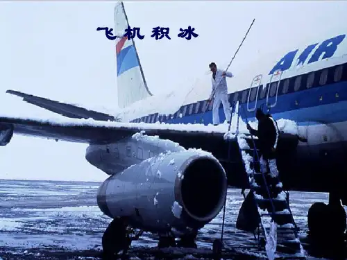
飞机积冰判断标准
飞机积冰的判断标准主要分为以下三类:
1.微量积冰(Trace):这种程度的积冰率稍大于升华。
除非出现的
时间很长,一般情况下微量积冰被认为是不会造成危害的。
2.轻度积冰(Light):如果这种程度的积冰出现时间超过一个小时
会给飞机带来一些问题,但如果间断地使用除冰/防冰设备就不会给飞行安全造成危害。
3.中度积冰(Moderate):即使短时间遇到这种程度的积冰也会有
潜在的危险性,遇到这种情况必须使用防冰设备,同时也可以考虑改变飞行高度或航向。
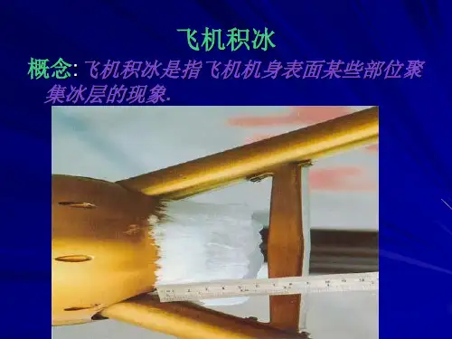
飞机积冰是飞机在云中、雨中或雾中飞行时,飞机表面某些部位聚集冰层的现象。
它对飞机的安全性能有很大影响。
按照积冰强度可分为:轻微积冰、中度积冰和严重积冰。
按积冰形成部位可分为:翼尖积冰、机翼表面积冰、尾翼积冰、前沿机身积冰、后沿机身积冰、进气道前缘积冰和后缘积冰、附着在发动机进气口前的积冰等。
Symbols for significant weather 重要天气现象符号Symbols for weather system 天气系统符号精选范本精选范本Thunder storms 雷暴 , Drizzle 毛毛雨Rain 雨Snow 雪Shower 阵雨Hail 雹Moderate turbulence 中度颠簸Freezing precipitation 冻降水Severe Turbulence 严重颠簸Widespread blowing snow 大片吹雪Moderate aircraft icing 中度飞机积冰Widespread haze 大片霾Severe aircraft icing 严重飞机积冰Widespread mist 大片轻雾Moderate waves 山地波Widespread fog 大片雾Tropical cyclone 热带气旋Widespread smoke 大片烟Severe squall line 严重飑线V olcanic eruption 火山喷发Severe sand or dust haze 严重沙或尘霾 ■ Visible ash cloud 火山灰云Widespread sandstorm or dust storm 大片沙(尘)暴Abbreviations used to describe weather 用于描述天气的缩写 MI :shallow 浅的 BC :patches 破碎的 PR :part 部分的 BL :blowing 高吹 DR :drifting 低吹 FZ :freezing 冻结的 SH :shower 阵雨 VC :vicinal 附近的 TS :thundstorm 雷暴的DZ :drizzle 毛毛雨 RA :rain 雨 SN :snow 雪SG :snow grains 米雪 IC :ice crystal 冰晶 PE :ice pellets 冰丸/冰粒 GR :hail 雹 GS :small hail and/or snow pellets 小雹/雪丸BR :mist 轻雾 FG :fog 雾 FU :smoke 烟 HZ :dust haze 尘霾 SA :sand 沙 DU :dust 尘 SQ :squall 飑 V A :volcanic ash 火山灰 SS :vsand storm 沙暴 DS :dust storm 尘暴PO :dust devils 尘卷风 FC :funnel cloud(water,spoutor tornado)漏斗云ISOL=isolated 个别的、孤立的 OCNL=occasional 偶然的、完全分离的 FRQ=frequent 成片的、不分离的 OBSC=obscure 不清楚的、边界模糊的 EMBD=embedded 隐嵌的 STNR=stationary 稳定少动的 INTSF =intensi fying加强的 WKN=weaken减弱的SEV=se vere 严重的 HVY=h eavy 强的 MOD=moderat e 中度的 FBL=fe eble 弱的实心风三角对应50海里/小时或93千米/小时(50KT/H or 93KM/H )。
飞机积冰在飞行中冰是个坏消息。
它破坏了空气的畅通,增加阻力,同时减少了机翼所产生的升力。
结冰对飞机重量的影响与它对气流的干扰相比是微不足道的。
随着油门增加,抬高机头弥补阻力带来的升力损失,攻角增加,造成机翼和机身底部积累更多的冰。
结冰会发生在飞机的所有暴露面,不仅仅是对翅膀,螺旋桨和挡风玻璃,而且天线,通风口,进水口和整流罩都会受到影响。
它通常产生于在飞行中如无发热的地方。
它能够引起天线震动,造成断裂。
在中度至重度的结冰条件下,小型飞机结冰将变得非常容易,因此继续飞行是不可能的。
飞机可能会在比平常更高的速度或者更低的攻角失速。
它使飞机在俯仰和滚动上面失控,并可能无法恢复。
结冰也肯能使汽化器冻结致使发动机停止,或在一个燃油喷射发动机的情况下,挡住了发动机的气源。
冰种和飞行及其影响结构冰这种东西,会凝固在飞机外面。
它被描述为霜,明冰(有时称为釉冰),和混合冰。
雾凇粗糙,外观呈乳白色,一般附着在表面的轮廓。
大部分可除去除冰或防冰设备都可预防。
明(或釉)冰有时是清晰流畅,但通常含有一些气泡,或块状,半透明的外观效果。
积冰越大,越符合机翼形状,其形状往往是由上,下为特点清除冰密集,更难,比雾凇冰更加透明,并且像“牛角”。
一般很难打破。
(冲击力越大的地方,机翼上的结冰就越少;这种形状像是上下两端凸起中间下凹的角。
明冰密度更大,更坚硬比雾凇更透明,通常也很难去除。
)混合冰是雾凇和明冰的组合。
冰可以在机翼表面空气流动扭曲,减少机翼的最大升力,降低了最大升力攻角,影响飞机的操纵品质,在风洞测试中表明,霜,雪,冰(在前沿或机翼上表面),厚度不超过一粗砂纸片可减少百分之三十升力和增加阻力高达百分之四十。
较大的附着,更会减少升力,可以增加百分之八十以上的阻力。
即使飞机进入结冰条件下飞行配备除冰系统,未受保护区域依然会有冰的积累。
美国航天局研究显示,近百分之三十的阻力依然存在即使已经对飞机的主要表面进行清理。
非保护表面可能包括天线,襟翼铰链,控制喇叭,机身前部区域,挡风玻璃刮水器,机翼支柱,固定起落架等。
不幸的是,一些粗心的飞行员们,遇到严重结冰的时候措手不及,并且没有相应的计划。
许多飞行员只从天气简报中的信息来确定哪些地方不容易结冰,哪些地方可能会出现结冰。
然而,飞行员可以学到足够的基本气象了解那里的冰可能会得到他们的等待。
飞行员可以在离开地面之前制定一些防冰除冰的飞行计划。
结冰飞机表面可以形成在0摄氏度(华氏32度)或更冷时液态水存在。
即使是最好的飞行计划也有一些变数。
虽然这是相当容易预测的地方结冰潜力的大面积存在,具体结冰地区和高度准确的预测会带来更多的困惑。
山,水,风,温度,湿度和大气压力在对这些决策方面都充当着重要的角色。
所有的云都不尽相同。
有干,湿云。
云干水分,相对较少,因此,对飞机结冰潜力低。
北达科他州,因为它非常寒冷的冬天,往往是干云。
然而,在宾夕法尼亚州和纽约的冬天往往会带来阿巴拉契亚山脉与冷空气和大量的湿云及大量水分,当温度冻结或以下,与冰加载。
大湖是一个非常大的水汽来源。
一个寒冷的空气质量的起源是多少过冷云水将进行的关键。
如果盛行风携带超过水云,他们可能会被淋湿了。
以上图表显示了潜在的高冰的一些领域。
结冰状况有时可能会出现在地图上显示的上述低风险地区。
锋面和低气压的地区是主要结冰的区域,但隔离空气充足的水分质量不稳定可以产生足够的结冰云,使轻型飞机无法通过。
冻雨和小雨是飞行中最大的敌人,可以大大粗糙飞机机翼表面积大的区域或扭曲机翼形状,这是对飞行非常危险的,即使在短短的几分钟内。
冻雨发生时,从高空暖空气降水通过将低于冷空气逆温层下面。
较大的水滴可能会在没有除冰加热的后方部位冻结。
随着一道冷锋,冷空气下温暖的空气,解除在潮湿的积云形成更加迅速和由此产生的。
沿着暖锋,温暖的空气往往滑过较冷的空气,有利于形成层云结冰。
当你接近前,云层建立非常迅速,层与层之间纯净的空气也会迅速消失。
冻雨和冰冻毛毛雨,包括冻结小雨升空,有时出现在锋面附近。
如果您选择它通过前,请确保它不包含冻雨或冻结小雨和其他有害,如天气条件嵌入式(隐藏)雷暴。
你应该计划飞行通过前最短的路线,而不是在锋面附近久留。
结构冰如何迅速采集冰表面上取决于其形状的一部分。
薄冰现代化的机翼将更加比厚的冰还要影响大,旧飞机的机翼尾部表面通常会结冰速度远远超过了翅膀。
如果尾部失速是由于冰和它引起的气流干扰,在低海拔处改出的可能性不大。
有许多运货飞机由于尾部失速而失事。
同时也发生在很多轻型飞机,但通常是没有很好的记载。
对于尾失速不太熟悉的许多飞行员,需要强调的是,机翼失速威胁更大,这是非常重要的正确区分这两个,因为所需采取的行动大致相反。
机翼失速机翼失速通常会在较低的攻角,从而较高速时,当冰累积。
即使是少量的冰会产生效果,如果冰粗糙,它会造成非常大的影响。
因此,我们建议若是遇到结冰情况,应该在进近的时候适当增大速度。
如何增加在很大程度上取决于机型和冰量。
请参考AFM或POH与冰相关会使飞机机翼失速特性变得不明显,而严重的滚转控制问题,也并不罕见。
积冰可能在两翼之间是不对称的。
隐藏,一边机翼,通常结冰较薄,从而更好地收集的冰,外面的部分可能会首先失速,比另外一边机翼更加迅速。
结冰对滚转控制的影响在副翼的翅膀上结冰可以影响滚转控制。
通用航空(GA)的飞机机翼的设计是使机翼先从跟部开始失速然后向外延伸开来,因此不会干扰副翼控制。
然而,翼尖通常要比后面的地方要薄,所以它们的机翼部分,更容易集冰。
这可能导致翼尖失速,可能会影响副翼,从而对滚转控制造成影响。
如果冰在副翼和边缘的链接部位积累,这可能会影响气流,干扰与副翼的正常运作。
如果副翼功能受损,如果遭遇这样的情况,上轻微向前压盘可能有助于使气流重新附着在副翼上。
Aircraft icingIce in flight is bad news. It destroys the smooth flow of air, increasing drag while decreasing the ability of the airfoil to create lift. The actual weight of ice on an airplane is insignificant when compared to the airflow disruption it causes. As power is added to compensate for the additional drag and the nose is lifted to maintain altitude, the angle of attack is increased, allowing the underside of the wings and fuselage to accumulate additional ice. Ice accumulates on every exposed frontal surface of the airplane—not just on the wings, propeller, and windshield, but also on the antennas, vents, intakes, and cowlings. It builds in flight where no heat or boots can reach it. It can cause antennas to vibrate so severely that they break. In moderate to severe conditions, a light aircraft can become so iced up that continued flight is impossible. The airplane may stall at much higher speeds and lower angles of attack than normal. It can roll or pitch uncontrollably, and recovery might be impossible.Ice can also cause engine stoppage by either icing up the carburetor or, in the case of a fuel-injected engine, blocking the engine’s air source.Kinds of Ice and Their Effects on FlightStructural ice is the stuff that sticks to the outside of the airplane. It is described as rime, clear (sometimes called glaze), or mixed.Rime ice has a rough, milky white appearance, and generally follows the contours of the surface. Much of it can be removed by deice systems or prevented by anti-ice.Clear (or glaze) ice is sometimes clear and smooth, but usually contains some air pockets that result in a lumpy, translucent appearance. The larger the accretion, the less glaze ice conforms to the shape of the wing; the shape is often characterized by the presence of upper and lower “horns.” Clear ice is denser, harder, and more transparent than rime ice, and is generally hard to break.Mixed ice is a combination of rime and clear ice.Ice can distort the flow of air over the wing, diminishing the wing’s maximum lift, reducing the angle of attack for maximum lift, adversely affecting airplane handling qualities, and significantly increasing drag. Wind tunnel and flight tests have shown that frost, snow, and ice accumulations (on the leading edge or upper surface of the wing) no thicker or rougher than a piece of coarse sandpaper can reduce lift by 30 percent and increase drag up to 40 percent. Larger accretions can reduce lift even more and can increase drag by 80 percent or more. Even aircraft equipped for flight into icing conditions are significantly affected by ice accumulation on the unprotected areas. A NASA study (NASA TM83564) showed that close to 30 percent of the total drag associated with an ice encounter remained after all the protected surfaces are cleared. No protected surfaces may include antennas, flap hinges, control horns, fuselage frontal area, windshield wipers, wing struts, fixed landing gear, etc.Some unwary pilots have, unfortunately, been caught by surprise with a heavy coating of ice and no plan of action. Many pilots get a weather briefing and have little or no idea how to determine where icing may occur. However, pilots can learn enough basicmeteorology to understand where ice will probably be waiting after they get their weather briefing. The pilot can then formulate an ice-avoidance flight plan before ever leaving the ground.Ice can form on aircraft surfaces at 0 degrees Celsius (32 degrees Fahrenheit) or colder when liquid water is present. Even the best plans have some variables. Although it is fairly easy to predict where the large areas of icing potential exist, the accurate prediction of specific icing areas and altitudes poses more of a quandary. Mountains, bodies of water, wind, temperature, moisture, and atmospheric pressure all play ever changing roles in weather-making. All clouds are not alike. There are dry clouds and wet clouds. Dry clouds have relatively little moisture and, as a result, the potential for aircraft icing is low. North Dakota, because of its very cold winters, is often home to dry clouds. However, winter in the Appalachians in Pennsylvania and New York often brings a tremendous amount of moisture with the cold air and lots of wet clouds that, when temperatures are freezing or below, are loaded with ice. The Great Lakes are a great moisture source. The origin of a cold air mass is a key to how much super cooled water the clouds will carry. If the prevailing winds carry clouds over water, they will probably be wet. The chart above shows some of the areas of high icing potential. Heavy icing conditions may sometimes occur in the low-risk areas shown on the map above.Fronts and low-pressure areas are the biggest ice producers, but isolated air mass instability with plenty of moisture can generate enough ice in clouds to make light aircraft flight inadvisable.Freezing rain and drizzle are the ultimate enemy that can drastically roughen large surface areas or distort airfoil shapes and make flight extremely dangerous or impossible in a matter of a few minutes. Freezing rain occurs when precipitation from warmer air aloft fallsthrough a temperature inversion into below-freezing air underneath. The larger droplets may impact and freeze behind the area protected by surface deicers.Along a cold front, the cold air plows under the warm air, lifting it more rapidly and resulting in the formation of moist cumulus. Along a warm front, the warmer air tends to slide over the colder air, forming stratus clouds conducive to icing. As you approach the front, the clouds build quickly and the clear air between layers rapidly disappears.Freezing rain and freezing drizzle, including freezing drizzle aloft, are sometimes found in the vicinity of fronts. If you choose to fly through the front, be sure that it does not contain freezing rain or freezing drizzle and other hazardous weather conditions such as embedded thunderstorms. You should plan on flying the shortest route through the front instead of flying the length of the front.Structural IceHow quickly a surface collects ice depends in part on its shape. Thin, modern wings will be more critical with ice on them than thick, older wing sections. The tail surfaces of an airplane will normally ice up much faster than the wing. If the tail stalls due to ice and the airflow disruption it causes, recovery is unlikely at low altitudes. Several air carrier aircraft have been lost due to tail stalls. It also happens to ligh t aircraft but usually isn’t well documented.Since a tail stall is less familiar to many pilots, it is emphasized in this advisor, but a wing stall is the much more common threat, and it is very important to correctly distinguish between the two, since the required actions are roughly oppositeWing StallThe wing will ordinarily stall at a lower angle of attack, and thus a higher airspeed, when contaminated with ice. Even small amounts of ice will have an effect, and if the ice is rough, it can be a large effect. Thus an increase in approach speed is advisable if ice remains on the wings. How much of an increase depends on both the aircraft type and amount of ice. Consult your AFM or POH.Stall characteristics of an aircraft with ice-contaminated wings will be degraded, and serious roll control problems are not unusual. The ice accretion may be asymmetric between the two wings. Also, the outer part of a wing, which is ordinarily thinner and thus a better collector of ice, may stall first rather than last.Effects of Icing on Roll ControlIce on the wings forward of the ailerons can affect roll control. Wings on general aviation (GA) aircraft are designed so that stall starts near the root of the wing and progresses outward, so the stall does not interfere with roll control of the ailerons. However, the tips are usually thinner than the rest of the wing, so they are the part of the wing that most efficiently collects ice. This can lead to a partial stall of the wings at the tips which can affect the ailerons and thus roll control.If ice accumulates in a ridge aft of the deice boots but forward of the ailerons, this can affect the airflow and interfere with proper functioning of the ailerons. If aileron function is impaired due to ice, slight forward pressure on the elevator may help to reattach airflow to the aileron.。