秘鲁简介 中英
- 格式:ppt
- 大小:2.06 MB
- 文档页数:21
Hello, I am Patty Kim. Get ready to explore Peru, home to stunning beaches, majestic mountains and of course, one of the most unforgettable places on earth, the great ruins of Machu Picchu, where the Mighty Inca once ruled.Roughly twice the size of Texas, Peru curves along the western coast of South America. The rugged Andes divides the country into three sections: the Amazon rain forest in the eastern half, the mountain highlands in the middle and a thin strip of bustling coastline in the west.A great way to start your trip from Lima, Peru's capital is by making your way to Cuzco, itself a capital city from the days of the Inca emperors. Exploring Cuzco in its markets will give you a chance to learn about Peru's history, and get used to walk in the high altitudes. At eleven thousand feet, the thin air makes any hike a toddler, but the practice will come in handy, Cuzco is the most popular entrance point for a four-day hike along the Inca trail, threading through forests and mountains on route to the majestic Inca mountain retreat, Machu Picchu.If hiking isn't your thing or if you are on a tight schedule, a trainer bus can get you there in about four hours. Either way, the approach is incredible. The destination, spectacular. Experts believe Machu Picchu was most likely built as a summer retreat for Inca royalty. Over two hundred buildings spread over five square miles. Temples, palaces and guard posts, the stone work is exacting. The blocks fit snugly together without using molder. One stone in particular, the intihuatana or the hitching post of the sun, was designed by Inca priests as part of the ritual to ensure the return of the sun after the winter solstice. Long after the Inca Empire’s reign, this crown jewel of ancient architecture stands as a fascinating testimony to these people and their beliefs.And the Inca wasn't the only civilization to leave their mark on Peru. Further west near the town of Nazca, hundreds of mysterious and gigantic lines over a thousand years old are edged into the dry plains. You can recognize the images only from the air: birds, spiders and other animals. Their true purpose is still a mystery, but many experts believe the Nazca linesplayed a religious and a practical role in finding water.On the other side of the Andes, water is hardly a problem. In Peru's lush rainforests lie the headwaters of the Amazon. Nature reserves here protect rare species and indigenous tribes. This is a nature lover's paradise. If you are looking for ways to get outdoors and watch wild life, whether along the rivers or up in the canopy, this is the place to be. You can take a thrilling walk above the canopy, suspended a hundred feet above the ground. You get a bird's eye view of life on the tree tops. And you don't have to travel too far off the beaten paths.A few travel tips as you plan your trip. The most popular time to go to Peru is during its dry season between June and August. During the rest of the year, you will have the added advantage of running into fewer tourists, but remember rain and thick clouds can obscure those mountain views. Altitude sickness can put a damper on your vacation, so plan it safe and give yourself a few extra days to adjust to the high elevations. With these few tips in mind, you are sure to get the most out of your travels andexperience the best of both worlds, Peru's ancient heart and its magnificent natural beauty.。
秘鲁概况一、政治类国名:秘鲁共和国(theRepublieofPeru)。
国名来历(释义):16世纪西班牙殖民者从巴拿马地峡来到这里,称其为秘鲁。
其含义有3种说法:1.在印第安克丘亚语中为“玉米之仓”之意;2.指注入太平洋一条河流之名;3.指一位印第安酋长之名。
政体:宪制共和国国家元首:亚历杭德罗·托莱多·曼里克总统(2001年7月28日-任期5年)。
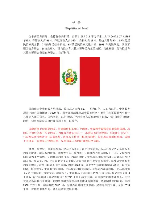
国旗:呈长方形,长与宽之比为3:2。
由三个平行相等的竖长方形组成,中间为白色,两侧为红色,白色长方形正中绘有国徽图案。
1820年领导南美人民反对西班牙殖民军的英雄何塞·德·圣马丁将军看到天空有一只展翅飞翔的奇鸟,该鸟有白色的胸脯、红色的翅膀,将军高兴的喊了起来:“看!自由的旗帜!”由此,秘鲁制定了红、白、红颜色的国旗。
白色象征自由、民主、和平与幸福;红色象征人民在独立战争中取得的胜利,也表示人民对烈士的怀念。
国徽:中心图案为盾徽。
盾面左上方是一只南美骆马,为该国国兽,代表国家的动物资源,也是秘鲁民族的象征之一;右上方是一棵金鸡纳树,代表该国的植物资源;下半部为一只象征丰饶的羊角,代表该国的自然资源和矿藏。
盾徽上端为一个绿枝叶环;两侧各有两面秘鲁国旗。
国花:向日葵、坎涂花国树:金鸡纳树国兽:羊骆国花:葵花。
邻国:北接厄瓜多尔、哥伦比亚,东接巴西,南接智利,东南接玻利维亚,西临太平洋。
重要节日:1.太阳节:6月24日,古代印加人把阳历6月24日定为南半球“冬至”,并在这天举行祭太阳神的活动,延续至今。
2.独立节(国庆日):7月28日(1821)。
首都:利马(1535年由西班牙人弗朗西斯科·皮萨罗建城)。
行政区划:全国划分为24个省和一个宪制区(卡亚俄直属区)。
各省名称如下:*亚马孙区域AmazonasRegion*安卡什区域AncashRegion*阿普里马克区域ApurímacRegion*阿雷基帕区域ArequipaRegion*阿亚库乔区域AyacuchoRegion*卡哈马卡区域CajamarcaRegion*卡亚俄区域CallaoRegion*库斯科区域CuscoRegion*万卡维利卡区域HuancavelicaRegion*瓦努科区域HuánucoRegion*伊卡区域IcaRegion*胡宁区域JunínRegion*拉利伯塔德区域LaLibertadRegion*兰巴耶克区域LambayequeRegion*利马区域LimaRegion(Capital)*洛雷托区域LoretoRegion*马德雷·德迪奥斯区域MadredeDiosRegion*莫克瓜区域MoqueguaRegion*帕斯科区域PascoRegion*皮乌拉区域PiuraRegion*普诺区域PunoRegion*圣马丁区域SanMartínRegion*塔克纳区域TacnaRegion*乌卡亚利区域UcayaliRegion政治:宪法规定,秘鲁“是在劳动基础上的独立自主的社会民主共和国”,总统由普选产生,任期5年,可以连任。
秘鲁(República del Perú)位于南美洲西部。
全称秘鲁共和国。
面积1 285 216平方千米。
人口2437.1万(1996年底)。
印第安人占41%,印欧混血人占36%,白种人占19%,其他人种占4%。
89%的居民信奉天主教,7%的居民信奉新教,4%的居民信奉其他宗教。
1993年宪法规定,西班牙语为官方语言,在克丘亚人、艾马拉人和其他土著居民为主的地区,克丘亚语、艾马拉语和其他土著语言也是官方语言。
首都利马。
国旗由三个垂直长方形组成,长与高之比为3:2。
中间为白色,左右为红色。
中间长方形正中绘有国徽图案。
1820年,南美洲南部独立战争领袖何塞·圣马丁将军看到天空有一只展翅飞翔的奇鸟,白色胸脯,红色翅膀,便对着奇鸟高兴地喊了起来:"看!自由的旗帜!"此后,秘鲁在制定国旗时便采用了红、白颜色。
国徽盾面上绘有美洲驼、金鸡纳树和羊角三个图案。
盾徽两旁装饰着四面秘鲁国旗。
盾面左上角伫立着一头美洲驼,为秘鲁民族象征之一,寓意国家的动物群。
在蔚蓝的天空下,它显得格外优雅矫健,温顺机警。
盾面右上角是一棵金鸡纳树,象征着国家的植物群。
盾面下半部是一只象征丰饶的羊角,象征国家丰富的矿藏等自然资源。
地理秘鲁位于南美洲西部。
北与厄瓜多尔、哥伦比亚为邻,东与巴西交界,东南与玻利维亚毗连,南与智利接壤,西濒太平洋。
境内多山,山地约占全国面积的一半。
全境从西向东分为3个截然不同的地理和经济区:西部沿海区、中部地区和东部林区。
安第斯山从北部入境,分成东、西、中科迪勒拉3条支脉,在南部汇成中部安第斯山脉,继续向智利和玻利维亚绵亘。
最高山峰瓦斯卡兰雪山,海拔6768米。
西部太平洋流域有河流60条,均由东向西,短而湍急,主要有通贝斯河、皮乌拉河和皮斯科河。
东部大西洋流域属于亚马孙河水系,多由南向北,水量充沛,流程绵长,主要有乌卡亚利河(1771千米)和马拉尼翁河(1414千米),为亚马孙河(在秘鲁境内长度713千米)两大支流。

秘鲁的介绍Peru OverviewFew destinations have as much to offer visitors as Peru, an astonishingly varied country. Here you’ll find panoramic mountain ranges, vast deserts, beautiful beaches and tropical jungle, not to mention fantastically rich history, archaeology, wildlife and enduring indigenous cultures.Images of the extraordinary remains of ancient civilizations will inevitably jump to mind. The Inca stronghold Machu Picchu is one of the most famous and photogenic archaeological sites in the world and the mysteriousNazca Lines boggle the mind, but there are hundreds of similarly fascinating and even older sites to discover.All are set in stunning landscapes, whether parched desert costa (coast), soaring sierra (mountains) or remote selva (rainforest) overflowing with wildlife. Such a diverse landscape generates diverse pleasures; the visitor can hike through snowy peaks one day, and relax on the beach the next; paddle a dugout through lowland rainforest or hop on a traditional reed boat on some of the worl d’s highest lakes.There are a wealth of sports and activities on offer, from sandboarding and surfing to extreme mountain biking and rafting. Add to this medicinal hot springs, mesmeric music, well-stocked museums, rich culture and uncommonly friendly people and you have a destination with something for everybody.GeographyPeru is a large, mountainous country on the Pacific coast of South America. It has borders with Ecuador and Colombia to the north, Brazil and Bolivia to the east, and Chile to the south. ThePacific Ocean lies to the west.There are three natural zones. The Costa region, which contains Lima (the capital), is a narrow coastal plain consisting of large tracts of desert broken by fertile valleys. The cotton, sugar and rice plantations and most of the so-far exploited oil fields lie in this area. The Sierra contains the Andes, with peaks over 6,000m (20,000ft), most of the country’s mineral resources (silver, zinc, lead, copper and gold) and the greater part of its livestock. The Selva, an area of fertile, subtropical land, lies between the Andes and the border with Brazil. The Amazonian jungle has vast natural resources. The absence of land communications, however, left the area largely uncharted until full-scale oil exploration began in 1973. The population is largely Indian and Mestizo with a noticeable influence from African, Chinese and European (mainly Spanish) settlers.秘鲁概述少的站点一样得到的观光者秘鲁,有着惊人不同的国家。


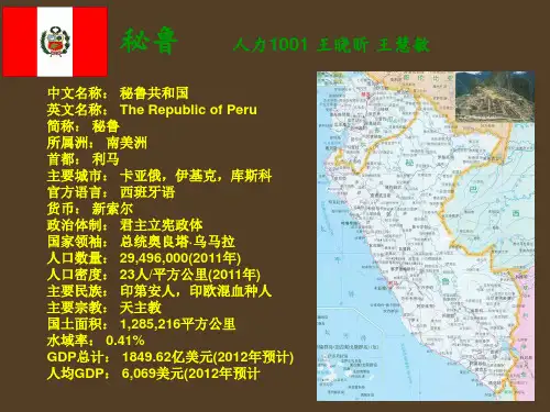
秘鲁简介秘鲁全称秘鲁共和国(the Republie of Peru),政体属宪制共和国。
现任国家元首:亚历杭德罗·托莱多·曼里克总统(2001年7月28日-任期5年)。
秘鲁全国面积:128万5千平方公里。
(1,285,216平方公里),人口:约2675万人(26,749,000)(2002年)。
城市人口约 72.2%;人口密度为每平方公里17人;平均寿命:男69岁,女72岁,人口自然增长率:约1.5%。
全国划分为24个省和一个宪制区(卡亚俄直属区)。
秘鲁国名来历有三种说法(释义):16世纪西班牙殖民者从巴拿马地峡来到这里,称其为秘鲁。
其含义有3种说法:1.在克丘亚语中为玉米之意;2.指注入太平洋一条河流之名;3.指一位印第安酋长之名。
秘鲁国旗由红、白、红3个相等的垂直长方形组成。
白色长方形正中绘有国徽图案。
1820年领导南美人民反对西班牙殖民军的英雄何塞·德·圣马丁将军看到天空有一只展翅飞翔的奇鸟,该鸟有白色的胸脯、红色的翅膀,将军高兴的喊了起来:“看!自由的旗帜!”由此,秘鲁制定了红、白、红颜色的国旗。
秘鲁的国花为葵花。
秘鲁的官方语言为西班牙语、克丘亚语和艾马拉语。
其他33种方言在印第安人中通用。
96%的国民信仰天主教,克丘亚人、艾马拉人和森林印第安人尚保留着农业宗教仪式和拜星教残余。
少数人信奉基督教新教。
秘鲁位于南美洲西海岸中部,与5个国家接壤,北邻哥伦比亚和厄瓜多尔,南接智利,东南毗玻利维亚,东界巴西,西濒太平洋,海岸线长254公里。
国土北端临近赤道,是个热带国家。
秘鲁全境从西向东分3个区域,依区域的不同,气候差异也极大。
从热带酷暑到极地的寒带气候,从几乎不下雨的海岸地区到多雨潮湿的森林地带都有。
气候分夏(干期)、冬(雨期)两季:春秋两季不明显。
1. 西部沿海海岸地区(Costa)为狭长的干旱地带,宽度为40至80公里,属热带沙漠、草原气候,干燥而温和,年平均气温12~32℃。
秘鲁共和国(The Republic of Peru, LaRepública del Perú)首都:利马(Lima)面积:1285216平方公里人口(万人):2394万(1996年)人口(分布):1991年人口增长率为20‰。
民族:秘鲁人口中,印第安人口最多,约为872万,占人口总数的41%,印欧混血种人口占36%,白人占19%,其他人占4%。
华侨3万多。
宗教:96%的居民信奉天主教。
克丘亚人、艾马拉人和森林印第安人尚保留着农业宗教仪式和拜星教残余。
少数人信奉基督教新教。
语言:官方语言为西班牙语与克丘亚语,克丘亚语的文字使用拉丁字母。
民风民俗:山区印第安人绝不坐在山坡上,因为他们敬畏生长在山坡上的苔藓。
在库斯科以东约80公里的冰山上(海拔4800米)相传耶稣曾于1780年在这里的一块岩石上显过圣。
于是印第安人就把它奉为"圣石",并在这里设祭坛,建圣祠和圣陵,岁岁朝拜。
印第安人中乌罗人是世界上原始的民族之一。
他们生活在的喀喀湖畔的香蒲之中。
行政区划:全国共分24个省和一个直属区(卡亚俄区)。
各省名称如下:亚马逊、安卡什、阿普里马克、阿雷基帕、阿亚库乔、卡哈马卡、库斯科、万卡维利卡、瓦努简、伊卡、胡宁、拉利伯塔德、兰巴耶克、利马、洛雷托、马德雷?德迪奥斯、莫克瓜、帕斯科、皮乌拉、普诺、圣马丁、塔克纳、通贝斯、乌卡亚里。
自然地理:拉丁美洲国家。
位于南美洲西部。
西濒太平洋,海岸线长2254公里;陆邻厄瓜多尔、哥伦比亚、巴西、玻利维亚和智利。
地形:自西向东明显地分成3个区:①西部沿海平原。
北部较宽,海相沉积层中富藏石油;②中部安第斯山区。
约占国土面积1/3以上。
呈西北一东南走向纵贯全境,平均海拔4300米,成为太平洋水系和大西洋水系的分水岭。
③ 东部亚马孙低地。
约占国土面积一半以上。
属亚马孙河上游流域,地面平缓,水网稠密。
北部贮有丰富的石油资源。
气候:地处热带,但各地区的气候差异极大。
Perú概况秘鲁,全称秘鲁共和国(西班牙语:República del Perú),是南美洲西部的一个国家,北邻厄瓜多尔和哥伦比亚,东与巴西和玻利维亚接壤,南接智利,西濒太平洋,为南美洲国家联盟的成员国。
秘鲁孕育了南美洲其中一个最早的文明──小北地区史前文明(Caral-Supe o Norte Chico),以及前哥伦布时期美洲最大的国家印加帝国。
16世纪,西班牙征服了印加帝国,建立秘鲁总督区。
中文名称: 秘鲁共和国首都: 利马(Lima)主要城市: 卡亚俄(Callao),库斯科(Cusco)国庆日/国庆日: 7月28日(1821年)官方语言: 西班牙语货币: Nuevo Sol总统: 奥良塔·乌马拉(Ollanta Humala Tasso)政治体制: República presidencialista国家标志:在古印第安语中,秘鲁意为“玉米之仓”,因此地盛产玉米而得名。
首都利马(Lima)被誉为“世界不雨城”。
秘鲁的主要语言西班牙语,是80.3%的5岁以上秘鲁人的第一语言。
一些印第安土语在部分地区同时通用,其中最重要的是克丘亚语(quechua),16.5%人口以此为第一语言。
主要旅游景点有:利马大广场、皇家费利佩城堡、托雷塔格莱宫、黄金博物馆、库斯科城、马丘比丘(Machu Picchu)遗址等。
安第斯山脉中的马丘比丘古城遗迹是目前保存最完好的印加古城之一,1983年被列入世界文化遗产名录。
著名的Dibujo de Nasca位于秘鲁境内。
铁路:秘是南美最早修建铁路的国家。
秘鲁是中南美地区华人最多的国家。
地理特点秘鲁位于南美洲西部,安第斯山纵贯南北,全境从西向东分为三个区域:西部沿海区为狭长的干旱地带,为热带沙漠区,有断续分布的平原,灌溉农业发达,城市人口集中;中部山地高原区主要为安第斯山中段,亚马孙河发源地,东部为亚马孙热带雨林区,属亚马孙河上游流域,为山麓地带与冲积平原,终年高温多雨,森林遍布,地广人稀,是近年新开发的石油产区。
秘鲁马丘比丘---失落之城英文介绍秘鲁马丘比丘:印加帝国“失落之城”,它是没有语言的印加文明留给世界的一个沉默证据;因为被建立在悬崖峭壁之上,又被称做“空中花园”。
Machu Picchu, the "Lost City of the Incas", as it was dubbed by the man who rediscovered it in the last century, is among the greatest tourist attractions in South America today and ranks among the most outstanding symbols in the Andean cultures.The legendary Inca settlement of Machu Picchu has become one of the world's iconic areas. Its haunting aura is enhanced by the mystery surrounding its use and abandonment.Machu Picchu is a manmade masterpiece blends into nature in the Andes.马丘比丘在上个世纪被再度发掘出来,发掘者称之为“印加失落之城”,它是当今南美顶级旅游胜地之一,是安第斯多种文明中最为耀眼的象征之一。
传说中的马丘比丘印加沉降已成为世界的标志性地区之一。
它的使用和废弃深了它神秘的光环。
被称为与安第斯的大自然融为一体的人工杰作。
The ancient city of Machu Picchu attracts visitors from all over the world. Historians believe the Inca began building Machu Picchu around the 1450s, but because they left no written records behind, no one knows exactly what their purpose was. Machu Picchu was built in the classical Inca style, with polished dry-stone walls. Its primary buildings are the Intihuatana, the Temple of the Sun, and the Room of the Three Windows.马丘比丘古城吸引了来自世界各地的游客。