常用航空气象符号
- 格式:doc
- 大小:392.00 KB
- 文档页数:2
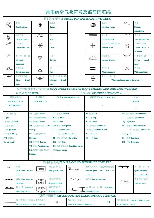
常用航空气象符号及缩写词汇编重要天气符号SYMBOLS FOR SIGNIFICANT WEATHER雷暴Thunderstorms毛毛雨Drizzle地形波Mountain waves冻雨 Freezing precipitation热带气旋Tropical cyclone雨 Rain大片雾 Widespread fog大片烟Widespread smoke严重飑线 Severe squall line雪Snow大片吹雪Widespreadblowing snow严重沙或尘霾Severe sand or dust haze中度颠簸Moderate turbulence阵雨 Shower火山喷发 V olcanic eruption严重飞机积冰 Severe aircrafticing严重颠簸 Severe turbulence雹 Hail大片轻雾 Widespread mist大片霾 Widespread haze轻度飞机积冰 Slight aircrafticing中度飞机积冰Moderate aircraft icing大片沙(尘)暴Widespread sandstorm or duststorm实时和预报重要天气代码表CODE TABLE FOR SIGNIFICANT PRESENT AND FORECAST WEATHER限定词QUALIFIER天气现象WEATHER PHENOMENA强度或趋势INTENSITY or PROXIMITY1说明摘要DESCRIPTOR2降水PRECIPITATION3视程障碍OBSCURATION4其它 OTHER5- 小(轻)的 Light中常的Moderate (无须说明) (No qualifier) + 强的 Heavy VC 在附近 In the vicinityMI 浅的 Shallow BC 散片的Patches PR 部分的 Partial DR 风吹起的低的 Low driftingBL 风吹起的高的BlowingSH 阵性的 Shower TS 雷暴 ThunderstormFZ 冻结的(过冷却的) FreezingDZ 毛毛雨 Drizzle RA 雨Rain SN 雪Snow SG 米雪 Snow grains IC 冰晶Ice Crystal钻石尘(Diamon dust) PE 冰粒(冰丸) Ice pellets GR 冰雹HailGS 小冰雹和/或霾Small hail and/or雪丸snow pellets BR 轻雾Mist FG 雾Fog FU 烟SmokeV A 火山灰V olcanic ash DU 浮尘 Widespread dust SA 沙Sand HZ 霾HazePO 尘/沙旋风 Dust/sandwhirls (尘卷风)(dust devils) SQ 飑SquallsFC 漏斗云 Funnel cloud(s)(海、陆龙卷)(tornado or waterspout) SS 沙暴Sandstorm DS 尘暴Duststorm锋线和辐合线FRONTS AND CONVERGENCE LINES ETC冷锋Cold front at the surface对流层顶高度Tropopause Level最大风的方向、速度及所处高度Position,speed and level of max.wind准静止锋Quasi-stationary front at the surface 暖锋Warm front at the surface对流层顶高点Tropopause High辐合线Convergence line零度等温层高度Freezing level锢囚锋Occluded front at the surface对流层顶低点 Tropopause Low热带辐合带Intertropicalconvergence zone标准等压面图例CHARTS FOR STANDARD ISOBARIC SURFACES压力等高线(高度以米为单位)Pressure isohypse(altitude in meters)等风速线(以节计)Isotachs of wind speed in knotsH等压面高压中心Centre of high altitude of the isobaric surface最大风速区Zone of maximum wind所选点的风速(短线5节,长线10节,黑三角50节)Wind at selected points(half abarb=5 knots, full barb=10 knots and atriangle50 knots)L 等压面低压中心Centre of low altitudeof the isobaric surface等温线(以摄氏度计)Isotherm(degrees Celsius)所选点的温度(以摄氏度计)Temperature atselected points(degree Celsius)重要天气图所用的其它符号OTHER SYMBOLS FOR PROGNOSTIC OR SIGNIFICANT WEATHER晴空颠簸区边缘Boundary of area of CAT零度等温线高度指示(若需)Height indication of 0℃ isotherm(if required)重要天气区边界Boundary of area of significant weather缩写(ABBREVIATIONS)CU 淡积云Cumulus SKC碧空Sky Clear(0/8)BECMG渐变Becoming EMBD隐藏的E,bedded FM起始时间FromTCU浓积云Toweringcumulus FEW疏云Few(1~2/8)TEMPO短时Temporary OBSC遮蔽的Obsured TL直到……TillCB 积雨云Cumulonimbus SCT少云Scattered(3~4/8)ISOL孤立的Isolated SQL飑线Squall Line CNS连续的ContinuousNS 雨层云Nimbostratus BKN多云Broken(5~7/8)OCNL偶然的Occasionally WDSPR广阔的Widespread COT海岸的CoastalAS 高层云Altostratus OVC满天云Overcast(8/8)FRQ频繁的Frequent PROB概率Probability LOC局部的LocallyAC 高积云Altocumulus CS 层积云Cirrostratus SC 层积云Stratocumulus LYR层状的Layer MON山区的MountainousCI 卷云Cirrus ST 层云Stratus DUC高空浓云Denseupper cloud NOSIG无重大变化No significant changeCC 卷积云Cirrocumulus CUF积状云Cumuliform STF层状云Stratiform CAT晴空颠簸Clear Air Turbulence。
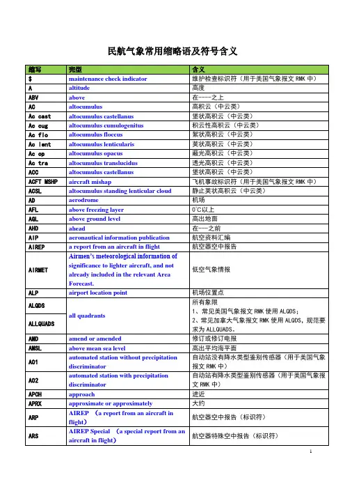
民航气象常用缩略语及符号含义天气现象名称、简语及符号类别种别记录完型符号雷电雷暴/雷雨TS/TSRA thunderstorm/ thunderstorm降水雨 RA rain 冻雨 FZRA freezing rain 阵雨 SHRA shower rain 毛毛雨 DZ drizzle 冻毛毛雨 FZDZ freezing drizzle 雨夹雪 RASN/SNRA rain and snow 阵性雨夹雪SHRASN/SHSNRAshower rain and snow雪 SN snow grains 阵雪 SHSN shower snow米雪SG now小冰雹/雪丸(霰)GS small hail and/or snowpellets冰雹 GR hail 冰粒 PL ice pellets 冰针 IC ice crystals 吹雪高吹雪BLSN blowing snow低吹雪 DRSN low drifting snow雾雾 FG fog 轻雾 BR mist冻雾FZFG freezing fog 浅雾 MIFG shallow fog 碎雾 BCFG patches fog 部分雾PRFGpartial fogSYMBOLS FOR SIGNIFICANT WEATHER 重要天气预告图中的天气现象及符号符号含义符号含义freezing precipitation 冻降水* tropical cyclone 热带气旋shower 阵雨 hail 雹drizzle 毛毛雨 severe squall line 强飑线**rain 雨 moderate turbulence 中度颠簸snow 雪severe turbulence 严重颠簸widespread fog 大范围的雾 moderate aircraft icing 中度积冰widespread mist 大范围的轻雾severe aircraft icing 严重积冰widespread haze 大范围的霾mountain waves 地形波widespread smoke 大范围的烟mountain obscuration 山体朦胧widespread blowing snow 大范围的吹雪volcanic eruption 火山喷发***widespread sandstorm or duststorm大片沙暴或尘暴radioactive materials in the atmosphere大气中的放射性物质***severe sand or dust haze 严重沙或尘霾*“冻降水”不是指在很低的温度下由于接触降水而引起的航空器积冰。
常用航空气象符号常用航空气象符号及缩写词汇编重要天气符号SYMBOLS FOR SIGNIFICANT WEATHER雷暴毛毛雨地形波冻雨 Thunderstorms Drizzle Mountain waves Freezingprecipitation热带气旋雨大片雾大片烟Tropical cyclone Rain Widespread fog Widespreadsmoke严重飑线雪大片吹雪W严重沙或尘霾 Severe squall Snow idespread blowing Severe sand orline snow dust haze中度颠簸M阵雨火山喷发严重飞机积冰 oderate Shower Volcanic eruption Severe aircraftturbulence icing严重颠簸雹大片轻雾大片霾 Severe Hail Widespread mist Widespread hazeturbulence轻度飞机积冰中度飞机积冰大片沙(尘)暴 Slight aircraft Moderate aircraft Widespread sandstorm or duststormicing icing实时和预报重要天气代码表CODE TABLE FOR SIGNIFICANT PRESENT AND FORECAST WEATHER限定词QUALIFIER 天气现象WEATHER PHENOMENA其它强度或趋势INTEN说明摘要D降水PRECIPITATION 视程障碍OBSCURATIONSITY or ESCRIPTOR OTHERPROXIMITY 3 41 2 5 - 小(轻)的 MI 浅的 Shallow DZ 毛毛雨 Drizzle BR 轻雾Mis tPO 尘/沙旋风 Dust/sandwhirls Light BC 散片的Patches RA 雨Rain FG 雾Fog (尘卷风)(dust devils) 中常的Moderate PR 部分的 Partial SN 雪Snow FU 烟Smoke SQ 飑Squalls (无须说明) DR风吹起的低的 Low SG 米雪 Snow grains VA 火山灰Volcanic ash FC 漏斗云 Funnel cloud(s)(No qualifier) drifting IC 冰晶Ice Crystal DU浮尘 Widespread dust (海、陆龙卷)(tornado or + 强的 Heavy BL 风吹起的高的Blow钻石尘(Diamon dust) SA 沙Sand waterspout) VC 在附近 ing PE 冰粒(冰丸) Ice pellets HZ 霾Haze SS 沙暴Sandstorm In the vicinity SH 阵性的 Shower GR 冰雹Hai lDS 尘暴DuststormTS 雷暴 Thunderstorm GS 小冰雹和/或霾Small hailFZ冻结的(过冷却的) and/orFreezing 雪丸snow pellets锋线和辐合线FRONTS AND CONVERGENCE LINES ETC冷锋对流层顶高度最大风的方向、速度及所处高度准静止锋Q Cold front at the Tropopause Level Position,speed and level of uasi-stationary surface max.wind front at thesurface暖锋Warm front at 对流层顶高点辐合线Convergence line 零度等温层高度 the surface Tropopause High Freezing level锢囚锋Occluded 对流层顶低点热带辐合带Intertropicalfront at the surface Tropopause Low convergence zone标准等压面图例CHARTS FOR STANDARD ISOBARIC SURFACES压力等高线(高度以米为单位)等风速线(以节计) 等压面高压中心Centre of high Pressure isohypse(altitude in H Isotachs of wind speed in knots altitude of the isobaric surface meters)所选点的风速(短线5节,长线10节,黑三角50节)Wind at selected points(half a 等压面低压中心Centre of low altitude 最大风速区Zone of maximum wind L barb=5 knots, full barb=10 knots and a of the isobaric surfacetriangle50 knots)等温线(以摄氏度计)所选点的温度(以摄氏度计)TemperatureIsotherm(degrees Celsius) at selected points(degree Celsius)重要天气图所用的其它符号OTHER SYMBOLS FOR PROGNOSTIC OR SIGNIFICANT WEATHER晴空颠簸区边缘Boundary of area of CAT零度等温线高度指示(若需)Height indication of 0? isotherm(if required)重要天气区边界Boundary of area of significant weather缩写(ABBREVIATIONS)CU 淡积云Cumulus SKC碧空Sky Clear(0/8) BECMG渐变Becoming EMBD隐藏的E,bedded FM起始时间From TCU浓积云Toweingcrumulus FEW疏云Few(1~2/8) TEMPO短时Temporary OBSC遮蔽的Obsured TL直到……Till CB 积雨云Cumulonimbus SCT少云Scattered(3~4/8) ISOL孤立的Isolated SQL飑线Squall Line CNS连续的Continuous NS 雨层云Nimbostratus BKN多云Broken(5~7/8) OCNL偶然的Occasionally WDSPR广阔的Widespread COT海岸的Coastal AS 高层云Altostratus OVC满天云Overcast(8/8) FRQ频繁的Frequent PROB概率Probability LOC局部的Locally AC 高积云Altocumulus CS 层积云Cirrostratus SC 层积云Stratocumulus LYR层状的Laye rMON山区的Mountainous CI 卷云 Cirrus ST 层云Stratus DUC高空浓云Denseupper NOSIG无重大变化No significant changecloudCC 卷积云Cirrocumulus CUF积状云Cumuliform STF层状云Stratiform CAT晴空颠簸Clear Air Turbulence。
飞行员想知道:气象报文中的字符特性符号CharacteristicsMI * *(Shallow)--浅的BC* *(Patches)--破碎的,散片状的PR* *(Partial)--部分的DR * *(Low Drifting)--低吹的(用于DU、SA、SN现象,吹起高度在2米以下)BL * *(Blowing)--高吹的(用于DU、SA、SN 现象,吹起高度在2米以上)SH* *(Shower)--阵性的(与RA,SNS,GS,GR组合)TS * *(Thunderstorm)--雷电(降水时与RA,SN,GS,GR 组合)FZ* *(Freezing)--冻(与FG,DZ,RA组合)降水现象符号PrecipitationDZ(Drizzle)--细雨、毛毛雨RA(Rain)--雨SN(Snow)--雪SG(Snow Grains)--米雪、雾雪IC(Ice Crystals /Diamond Dust)--冰晶/钻石星尘(视距1000米以上5000米以下)PL(Ice Pellets)--冰粒GR(Hail)-冰雹GS(Small hail /Snow Pellets)--小冰雹,雪粒视觉障碍现象符号ObscurationBR(Mist)--薄雾(视距1000米以上5000米以下)FG(Fog)--雾(视距1000米以下)FU(Smoke)--烟(视距5000米以下)VA(Volcanic Ash)--火山灰DU(Widespread Dust)--尘(DU,BLDU是能见度5000米以下)SA(Sand)--(SA,BLSA是能见度5000米以下,SA被当作黄沙)HZ(Haze)--霾、烟雾、灰尘烟雾(烟雾等)其他的现象CharacteristicsPO(Well - developed Dust / Sand Whirls)--尘旋风SQ(Squalls)--飑FC(Funnel Cloud)--漏斗云SS(Sand storm)--沙旋风DS(Dust storm)--尘旋风云量Cloud CoverageSKC(Sky Clear)--云量0 / 8(无)云FEW(Few)--云量1 / 8SCT(Scattered)--云量3 / 8~4 / 8BKN(Broken)--云量5 / 8~7 / 8 云量BKN以上Ceiling OVC(Overcast)--云量8 / 8(整个天空覆盖云)云形Types CloudAC(Altocumulus)--高积云AS(Altostratus)--高层云CB(Cumulonimbus)--积雨云(积雨云),砧状云CC(Cirrocumulus)--卷积云,斑点状云SL(Standing LenticularCloud)--静止的荚状云CI(Cirrus)--卷,云卷云CS(Cirrostratus)--卷层云CU(Cumulus)--积云NS(Nimbostratus)--雨层云SC(Stratocumulus)--层积云ST(Stratus)--层云TCU(T owering Cumulus)--浓积云例子:4CU015 = 4 / 8云量的积云高度1500 ft。
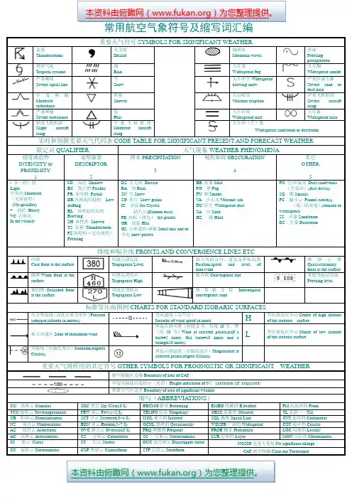


常用航空气象符号及缩写词汇编重要天气符号SYMBOLS FOR SIGNIFICANT WEATHER雷暴Thunderstorms毛毛雨Drizzle地形波Mountain waves冻雨 Freezing precipitation热带气旋Tropical cyclone雨 Rain大片雾 Widespread fog大片烟Widespread smoke严重飑线 Severe squall line雪Snow大片吹雪Widespreadblowing snow严重沙或尘霾Severe sand or dust haze中度颠簸Moderate turbulence阵雨 Shower火山喷发 V olcanic eruption严重飞机积冰 Severe aircrafticing严重颠簸 Severe turbulence雹 Hail大片轻雾 Widespread mist大片霾 Widespread haze轻度飞机积冰 Slight aircrafticing中度飞机积冰Moderate aircraft icing大片沙(尘)暴Widespread sandstorm or duststorm实时和预报重要天气代码表CODE TABLE FOR SIGNIFICANT PRESENT AND FORECAST WEATHER限定词QUALIFIER天气现象WEATHER PHENOMENA强度或趋势INTENSITY or PROXIMITY1说明摘要DESCRIPTOR2降水PRECIPITATION3视程障碍OBSCURATION4其它 OTHER5- 小(轻)的 Light中常的Moderate (无须说明) (No qualifier) + 强的 Heavy VC 在附近 In the vicinityMI 浅的 Shallow BC 散片的Patches PR 部分的 Partial DR 风吹起的低的 Low driftingBL 风吹起的高的BlowingSH 阵性的 Shower TS 雷暴 ThunderstormFZ 冻结的(过冷却的) FreezingDZ 毛毛雨 Drizzle RA 雨Rain SN 雪Snow SG 米雪 Snow grains IC 冰晶Ice Crystal钻石尘(Diamon dust) PE 冰粒(冰丸) Ice pellets GR 冰雹HailGS 小冰雹和/或霾Small hail and/or雪丸snow pellets BR 轻雾Mist FG 雾Fog FU 烟SmokeV A 火山灰V olcanic ash DU 浮尘 Widespread dust SA 沙Sand HZ 霾HazePO 尘/沙旋风 Dust/sandwhirls (尘卷风)(dust devils) SQ 飑SquallsFC 漏斗云 Funnel cloud(s)(海、陆龙卷)(tornado or waterspout) SS 沙暴Sandstorm DS 尘暴Duststorm锋线和辐合线FRONTS AND CONVERGENCE LINES ETC冷锋Cold front at the surface对流层顶高度Tropopause Level最大风的方向、速度及所处高度Position,speed and level of max.wind准静止锋Quasi-stationary front at the surface 暖锋Warm front at the surface对流层顶高点Tropopause High辐合线Convergence line零度等温层高度Freezing level锢囚锋Occluded front at the surface对流层顶低点 Tropopause Low热带辐合带Intertropicalconvergence zone标准等压面图例CHARTS FOR STANDARD ISOBARIC SURFACES压力等高线(高度以米为单位)Pressure isohypse(altitude in meters)等风速线(以节计)Isotachs of wind speed in knotsH等压面高压中心Centre of high altitude of the isobaric surface最大风速区Zone of maximum wind所选点的风速(短线5节,长线10节,黑三角50节)Wind at selected points(half abarb=5 knots, full barb=10 knots and atriangle50 knots)L 等压面低压中心Centre of low altitudeof the isobaric surface等温线(以摄氏度计)Isotherm(degrees Celsius)所选点的温度(以摄氏度计)Temperature atselected points(degree Celsius)重要天气图所用的其它符号OTHER SYMBOLS FOR PROGNOSTIC OR SIGNIFICANT WEATHER晴空颠簸区边缘Boundary of area of CAT零度等温线高度指示(若需)Height indication of 0℃ isotherm(if required)重要天气区边界Boundary of area of significant weather缩写(ABBREVIATIONS)CU 淡积云Cumulus SKC碧空Sky Clear(0/8)BECMG渐变Becoming EMBD隐藏的E,bedded FM起始时间FromTCU浓积云Toweringcumulus FEW疏云Few(1~2/8)TEMPO短时Temporary OBSC遮蔽的Obsured TL直到……TillCB 积雨云Cumulonimbus SCT少云Scattered(3~4/8)ISOL孤立的Isolated SQL飑线Squall Line CNS连续的ContinuousNS 雨层云Nimbostratus BKN多云Broken(5~7/8)OCNL偶然的Occasionally WDSPR广阔的Widespread COT海岸的CoastalAS 高层云Altostratus OVC满天云Overcast(8/8)FRQ频繁的Frequent PROB概率Probability LOC局部的LocallyAC 高积云Altocumulus CS 层积云Cirrostratus SC 层积云Stratocumulus LYR层状的Layer MON山区的MountainousCI 卷云Cirrus ST 层云Stratus DUC高空浓云Denseupper cloud NOSIG无重大变化No significant changeCC 卷积云Cirrocumulus CUF积状云Cumuliform STF层状云Stratiform CAT晴空颠簸Clear Air Turbulence。
模式SN用于飞行文件的符号1.重要天气符号*在为飞行高度层100以下飞行的飞行文件中•这个符号指“飓线†下列情报涉及的符号应该在图边标明:放射物符号:意外事故点的经/纬度:总外爭故发生的日期和时间:进一步情报的核对航行通告。
‡下列情报应该在图边标明:火山喷发符号:火山名字和国际编号(如果知道):经/纬度:首次喷发的日期和时间(如果知道):关于火山灰的核对重要气象情报和航行通告或火山通告。
§这个符号不涉及在很低温度下由于降水而引起的飞机枳冰。
桶紳*可见的火山云符号仅仅适用于VAG模式,对SIGWX图不适用。
注:每幅图例的预期现象的底顶间尚度扌斤示。
风矢表明急流的最大风和所在的飞行高度层。
用双横线标明大于或等于20海里/小时的风速变化和3000英尺(或更小,如果可 行)的飞行高度层的显著变化。
在此例中,双横线处风速是225公里/小时(120公里/ 小时)。
粗线描绘预报风速为150公里/小时(80公里/小时)的急流轴的起始点和终止点。
*该符号指出大范围地面风速超过60公里/小时(30海里/小时)。
3. 3高度在SWH 和SWM 图上的高度都用飞行高度层表示,当用XXX 表示底或顶的髙度时,底高或 顶髙都在SWL 图的气层以外。
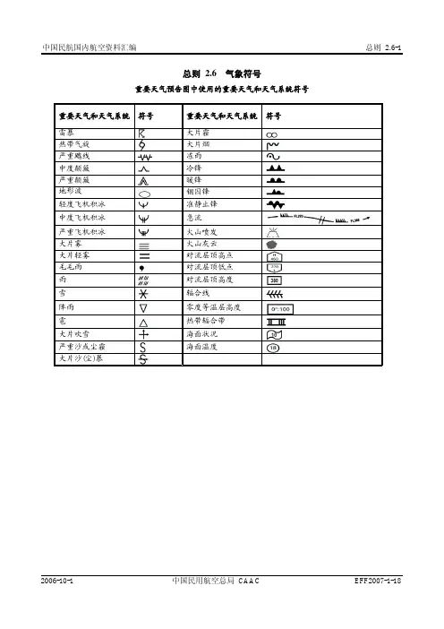
3.2云量 除CB 以外的云:SKC =碧空(0/8) FEW 二少云(1/8-2/8) SCT =疏云(3/8-4/8)BKN 二多云(5/8-7/8)0VC =阴天(8/8)NS 一雨层云ST 一层云 CB 一积雨云 只限CB :IS0L =个别(孤立的)CB OCNL =完全分离的CB FRQ =很少或不分离的CBEMBD =隐嵌在其他云层中或隐嵌在霾里的CB 3.用于描述云的缩写3. 1云状 CI 一卷云 CS 一卷层云 CC 一卷积云AC 一髙积云AS 一髙层云 SC 一层积云CU 一积云A. 1重要天气预告图的制作 A. 1.1重要天气预告图分为:a) 髙层重要天气预告图(SWH):供飞行高度大于FL250 (7 500 m)的髙空飞行使用: b) 中层重要天气预告图(SO):供飞行髙度小于等于FL250 (7 500 m)大于FL100(3 000 m)的中空飞行使用;c) 低层重要天气预告图(SWL):供飞行髙度小于等于FL100 (3 000 m)的低空飞行 使用。
常用航空气象符号常用航空气象符号及缩写词汇编重要天气符号SYMBOLS FOR SIGNIFICANT WEATHER雷暴毛毛雨地形波冻雨 Thunderstorms Drizzle Mountain waves Freezingprecipitation热带气旋雨大片雾大片烟Tropical cyclone Rain Widespread fog Widespreadsmoke严重飑线雪大片吹雪W严重沙或尘霾 Severe squall Snow idespread blowing Severe sand orline snow dust haze中度颠簸M阵雨火山喷发严重飞机积冰 oderate Shower Volcanic eruption Severe aircraftturbulence icing严重颠簸雹大片轻雾大片霾 Severe Hail Widespread mist Widespread hazeturbulence轻度飞机积冰中度飞机积冰大片沙(尘)暴 Slight aircraft Moderate aircraft Widespread sandstorm or duststormicing icing实时和预报重要天气代码表CODE TABLE FOR SIGNIFICANT PRESENT AND FORECAST WEATHER限定词QUALIFIER 天气现象WEATHER PHENOMENA其它强度或趋势INTEN说明摘要D降水PRECIPITATION 视程障碍OBSCURATIONSITY or ESCRIPTOR OTHERPROXIMITY 3 41 2 5 - 小(轻)的 MI 浅的 Shallow DZ 毛毛雨 Drizzle BR 轻雾Mis tPO 尘/沙旋风 Dust/sandwhirls Light BC 散片的Patches RA 雨Rain FG 雾Fog (尘卷风)(dust devils) 中常的Moderate PR 部分的 Partial SN 雪Snow FU 烟Smoke SQ 飑Squalls (无须说明) DR风吹起的低的 Low SG 米雪 Snow grains VA 火山灰Volcanic ash FC 漏斗云 Funnel cloud(s)(No qualifier) drifting IC 冰晶Ice Crystal DU浮尘 Widespread dust (海、陆龙卷)(tornado or + 强的 Heavy BL 风吹起的高的Blow钻石尘(Diamon dust) SA 沙Sand waterspout) VC 在附近 ing PE 冰粒(冰丸) Ice pellets HZ 霾Haze SS 沙暴Sandstorm In the vicinity SH 阵性的 Shower GR 冰雹Hai lDS 尘暴DuststormTS 雷暴 Thunderstorm GS 小冰雹和/或霾Small hailFZ冻结的(过冷却的) and/orFreezing 雪丸snow pellets锋线和辐合线FRONTS AND CONVERGENCE LINES ETC冷锋对流层顶高度最大风的方向、速度及所处高度准静止锋Q Cold front at the Tropopause Level Position,speed and level of uasi-stationary surface max.wind front at thesurface暖锋Warm front at 对流层顶高点辐合线Convergence line 零度等温层高度 the surface Tropopause High Freezing level锢囚锋Occluded 对流层顶低点热带辐合带Intertropicalfront at the surface Tropopause Low convergence zone标准等压面图例CHARTS FOR STANDARD ISOBARIC SURFACES压力等高线(高度以米为单位)等风速线(以节计) 等压面高压中心Centre of high Pressure isohypse(altitude in H Isotachs of wind speed in knots altitude of the isobaric surface meters)所选点的风速(短线5节,长线10节,黑三角50节)Wind at selected points(half a 等压面低压中心Centre of low altitude 最大风速区Zone of maximum wind L barb=5 knots, full barb=10 knots and a of the isobaric surfacetriangle50 knots)等温线(以摄氏度计)所选点的温度(以摄氏度计)TemperatureIsotherm(degrees Celsius) at selected points(degree Celsius)重要天气图所用的其它符号OTHER SYMBOLS FOR PROGNOSTIC OR SIGNIFICANT WEATHER晴空颠簸区边缘Boundary of area of CAT零度等温线高度指示(若需)Height indication of 0? isotherm(if required)重要天气区边界Boundary of area of significant weather缩写(ABBREVIATIONS)CU 淡积云Cumulus SKC碧空Sky Clear(0/8) BECMG渐变Becoming EMBD隐藏的E,bedded FM起始时间From TCU浓积云Toweingcrumulus FEW疏云Few(1~2/8) TEMPO短时Temporary OBSC遮蔽的Obsured TL直到……Till CB 积雨云Cumulonimbus SCT少云Scattered(3~4/8) ISOL孤立的Isolated SQL飑线Squall Line CNS连续的Continuous NS 雨层云Nimbostratus BKN多云Broken(5~7/8) OCNL偶然的Occasionally WDSPR广阔的Widespread COT海岸的Coastal AS 高层云Altostratus OVC满天云Overcast(8/8) FRQ频繁的Frequent PROB概率Probability LOC局部的Locally AC 高积云Altocumulus CS 层积云Cirrostratus SC 层积云Stratocumulus LYR层状的Laye rMON山区的Mountainous CI 卷云 Cirrus ST 层云Stratus DUC高空浓云Denseupper NOSIG无重大变化No significant changecloudCC 卷积云Cirrocumulus CUF积状云Cumuliform STF层状云Stratiform CAT晴空颠簸Clear Air Turbulence。
常用航空气象符号及缩写词汇编
重要天气符号SYMBOLS FOR SIGNIFICANT WEATHER
雷暴
Thunderstorms
毛毛雨
Drizzle
地形波
Mountain waves
冻雨 Freezing precipitation
热带气旋
Tropical cyclone
雨 Rain
大片雾 Widespread fog
大片烟 Widespread smoke
严重飑线 Severe squall
line
雪 Snow
大片吹雪
Widespread blowing snow
严重沙或尘霾 Severe sand or dust haze
中度颠簸
Moderate turbulence
阵雨 Shower
火山喷发 Volcanic eruption
严重飞机积冰 Severe aircraft
icing
严重颠簸 Severe turbulence
雹 Hail
大片轻雾 Widespread mist
大片霾
Widespread haze
轻度飞机积冰 Slight aircraft
icing
中度飞机积冰Moderate aircraft icing
大片沙(尘)暴
Widespread sandstorm or duststorm
实时和预报重要天气代码表CODE TABLE FOR SIGNIFICANT PRESENT AND FORECAST WEATHER
限定词QUALIFIER
天气现象WEATHER PHENOMENA
强度或趋势INTENSITY or PROXIMITY
1
说明摘要DESCRIPTOR
2
降水PRECIPITATION
3
视程障碍OBSCURATION
4
其它 OTHER
5
- 小(轻)的 Light
中常的Moderate (无须说明) (No qualifier) + 强的 Heavy VC 在附近 In the vicinity
MI 浅的 Shallow BC 散片的Patches PR 部分的 Partial DR 风吹起的低的 Low drifting
BL 风吹起的高的Blowing
SH 阵性的 Shower TS 雷暴 Thunderstorm
FZ 冻结的(过冷却的) Freezing
DZ 毛毛雨 Drizzle RA 雨Rain SN 雪Snow
SG 米雪 Snow grains IC 冰晶Ice Crystal
钻石尘(Diamon dust) PE 冰粒(冰丸) Ice pellets GR 冰雹Hail
GS 小冰雹和/或霾Small hail
and/or 雪丸snow pellets
BR 轻雾Mist FG 雾Fog FU 烟Smoke
V A 火山灰Volcanic ash DU 浮尘 Widespread dust SA 沙Sand HZ 霾Haze
PO 尘/沙旋风 Dust/sandwhirls (尘卷风)(dust devils) SQ 飑Squalls
FC 漏斗云 Funnel cloud(s)
(海、陆龙卷)(tornado or waterspout) SS 沙暴Sandstorm DS 尘暴Duststorm
锋线和辐合线FRONTS AND CONVERGENCE LINES ETC
冷锋
Cold front at the surface
对流层顶高度
Tropopause Level
最大风的方向、速度及所处高度
Position,speed and level of max.wind
准静止锋
Quasi-stationary front at
the
surface
暖锋Warm front at the surface 对流层顶高点
Tropopause High
辐合线Convergence line
零度等温层高度
Freezing level
锢囚锋Occluded front at the surface
对流层顶低点 Tropopause Low
热带辐合带
Intertropical
convergence zone
标准等压面图例CHARTS FOR STANDARD ISOBARIC SURFACES
压力等高线(高度以米为单位)
Pressure isohypse(altitude in
meters)
等风速线(以节计)
Isotachs of wind speed in knots
H 等压面高压中心Centre of high
altitude of the isobaric surface 最大风速区Zone of maximum wind
所选点的风速(短线5节,长线10节,黑
三角50节)Wind at selected points(half a
barb=5 knots, full barb=10 knots and a
triangle50 knots)
L 等压面低压中心Centre of low altitude
of the isobaric surface
等温线(以摄氏度计)
Isotherm(degrees Celsius)
所选点的温度(以摄氏度计)Temperature at
selected points(degree Celsius)
重要天气图所用的其它符号OTHER SYMBOLS FOR PROGNOSTIC OR SIGNIFICANT WEATHER
晴空颠簸区边缘Boundary of area of CAT
零度等温线高度指示(若需)Height indication of 0℃ isotherm(if required)
重要天气区边界Boundary of area of significant weather
缩写(ABBREVIATIONS)
CU 淡积云Cumulus SKC碧空Sky Clear(0/8)BECMG渐变Becoming EMBD隐藏的E,bedded FM起始时间From
TCU浓积云Toweringcumulus FEW疏云Few(1~2/8)TEMPO短时Temporary OBSC遮蔽的Obsured TL直到……Till
CB 积雨云Cumulonimbus SCT少云Scattered(3~4/8)ISOL孤立的Isolated SQL飑线Squall Line CNS连续的Continuous
NS 雨层云Nimbostratus BKN多云Broken(5~7/8)OCNL偶然的Occasionally WDSPR广阔的Widespread COT海岸的Coastal
AS 高层云Altostratus OVC满天云Overcast(8/8)FRQ频繁的Frequent PROB概率Probability LOC局部的Locally
AC 高积云Altocumulus CS 层积云Cirrostratus SC 层积云Stratocumulus LYR层状的Layer MON山区的Mountainous
CI 卷云Cirrus ST 层云Stratus DUC高空浓云Denseupper
cloud
NOSIG无重大变化No significant change
CC 卷积云Cirrocumulus CUF积状云Cumuliform STF层状云Stratiform CAT晴空颠簸Clear Air Turbulence。