欧洲空间发展战略(破解版)
- 格式:pdf
- 大小:3.30 MB
- 文档页数:98
RESEARCH ARTICLEA standardized procedure for surveillance and monitoring European habitats and provision of spatial dataR.G.H.BunceÆM.J.MetzgerÆR.H.G.JongmanÆJ.BrandtÆG.de BlustÆR.Elena-RosselloÆG.B.GroomÆL.HaladaÆG.HoferÆD.C.HowardÆP.Kova´rˇÆC.A.Mu¨cherÆE.Padoa-SchioppaÆD.PaelinxÆA.PaloÆM.Perez-SobaÆI.L.RamosÆP.RocheÆH.Ska˚nesÆT.WrbkaReceived:9November2006/Accepted:14October2007/Published online:9November2007ÓSpringer Science+Business Media B.V.2007Abstract Both science and policy require a practical,transmissible,and reproducible procedure for surveillance and monitoring of European habitats,which can produce statistics integrated at the landscape level.Over the last30years,landscape ecology has developed rapidly,and many studies nowR.G.H.Bunce(&)ÁR.H.G.JongmanÁC.A.Mu¨cherÁM.Perez-SobaAlterra Wageningen University and Research Centre, P.O.Box47,Wageningen6700AA,The Netherlandse-mail:bob.bunce@wur.nlM.J.MetzgerEnvironmental Systems Analysis group,Wageningen University,Wageningen,The NetherlandsPresent Address:M.J.MetzgerCentre for the Study of Environmental Change and Sustainability(CECS),School of Geo-Sciences,University of Edinburgh,Crew Building,Edinburgh EH93JN,UK J.BrandtÁD.PaelinxDepartment of Environmental,Social and Spatial Change, Roskilde University,P.O.Box260,Roskilde4000, DenmarkG.de BlustResearch Institute for Nature and Forest,Kliniekstraat25, Brussels1070,BelgiumR.Elena-RosselloDepartment of Forestry,Polytechnic Universityof Madrid,Madrid28040,SpainG.B.GroomDepartment of Wildlife Ecology and Biodiversity,NERI, Kalø,Grenaavej14,Roende8410,Denmark L.HaladaInstitute of Landscape Ecology,Slovak Academyof Sciences,Akademicka2,Nitra94901,Slovak RepublicG.HoferART Agroscope Reckenholz-Ta¨nikon,Swiss Federal Research Station,Zu¨rich8046, SwitzerlandD.C.HowardCentre for Ecology and Hydrology,Library Avenue, Bailrigg,Lancaster LA14AP,UKP.Kova´rˇFaculty of Science,Charles University,Benatska2,Prague12801,Czech RepublicE.Padoa-SchioppaDepartment of Landscape and Environmental Sciences, University of Milano-Bicocca,Piazza della Scienza1, Milan20126,ItalyA.PaloInstitute of Geography,University of Tartu,46Vanemuise Street,Tartu51014,EstoniaI.L.RamosCESUR,Avenida Rovisco Pais,Lisbon1049-001, PortugalLandscape Ecol(2008)23:11–25 DOI10.1007/s10980-007-9173-8require spatial data on habitats.Without rigorous rules,changes from baseline records cannot be separated reliably from background noise.A proce-dure is described that satisfies these requirements and can provide consistent data for Europe,to support a range of policy initiatives and scientific projects.The methodology is based on classical plant life forms, used in biogeography since the nineteenth century, and on their statistical correlation with the primary environmental gradient.Further categories can there-fore be identified for other continents to assist large scale comparisons and modelling.The model has been validated statistically and the recording proce-dure tested in thefield throughout Europe.A total of 130General Habitat Categories(GHCs)is defined. These are enhanced by recording environmental,site and management qualifiers to enableflexible data-base interrogation.The same categories are applied to areal,linear and point features to assist recording and subsequent interpretation at the landscape level.The distribution and change of landscape ecological parameters,such as connectivity and fragmentation, can then be derived and their significance interpreted. Keywords Field recordingÁStratified samplingÁBiodiversityÁMonitoringÁSurveillanceÁRaunkiaer plant life formsÁGeneral habitat categoriesIntroductionWhen recording habitats and biodiversity at the landscape level,the difficulty has always been in reconciling the observed complexity of points,lines and patches with recognisable categories that can be consistently and repeatedly recorded in thefield and then converted into national and regional estimates.It is therefore necessary to link the detailed records to a strategic framework,as described by Sheail and Bunce(2003).Monitoring and surveillance also have to be integrated spatially and temporally with other data sources.The primary goal of this paper is to describe a system that can lead to the production of a statistical profile of interdependent systems that make up European landscapes,and subsequently to enable the assessment of changes resulting from landscape ecological processes,such as fragmentation.The approach will enable the landscape ecological resources of the continent to be determined and, because it is based on plant life forms which are applicable throughout the world,further categories could therefore be developed for other continents.In thefinal plenary session at the2007IALE World Congress(International Association for Land-scape Ecology),the assessment of change in landscape ecological elements at the strategic level was identified as an important topic for future research.Many regional studies and some national inventories are provided in Bunce et al.(2007),but none at a continental scale.Surprisingly,within the Congress,the Symposium on Monitoring did not identify any new methodologies,probably because of regular communication within the IALE community.Policy makers and land managers increasingly demand hardfigures that detail the state of biodiver-sity and habitats,as well as the definition of historical trends.Arguments over the responsibility of man in driving global environmental change make the demand for incontrovertible evidence ever greater (Reid2005).Such statistics are not only important for local and national policies,but may also be used to evaluate international conventions and commitments (e.g.,the Goteborg Commitment by the European Union(EU)to halt biodiversity loss by2010). However,there is a lack of consistent data to meet these requirements,especially at the supra-national level.Currently,reporting is based on national programs,without accepted protocols.As a result there are no consistentfigures on habitats for Europe, because the available maps are derived from satellite imagery and are not at a sufficiently detailed level.Throughout the world there are also many products at a strategic scale derived from satellite imagery,but usually with no link to in situ data.P.RocheUniversity Paul Cezanne,IMEP UMR6116CNRS, Europole de l’Arbois,B.P.80,13545Aix-en-Provence cedex4,Marseille,FranceH.Ska˚nesDepartment of Physical Geography and Quaternary Geology,Stockholm University,Stockholm10691, SwedenT.WrbkaInstitute of Conservation Biology,Vegetation Ecology and Landscape Ecology,University of Vienna, Althanstrasse14,Vienna1090,AustriaRegional landscape ecological studies are more common;e.g.,Jones et al.(2001)provide a broad view of the relevance of assessing landscape ecolog-ical changes and give an example at the regional scale in the United Sates.They point out that,whilst there had been successful development of methods for broad scale assessment,a critical limitation was thatfield based methods had proved to be inconsis-tent.However,new data on land cover change are now available;e.g.,the North American Landscape Characterisation program(NALC)contains an archive of Landsat Multispectral Scanner(MSS) images.Vogelman et al.(2001)also describe a comparable program.Taken together these two programs permit relativelyfine scale assessments of landscape change across large areas,but they are not integrated with habitat records.Also,in the United States the Environmental Protection Agency(EPA, /emap)is developing tools for monitoring,but there is no national coverage of habitats. In Australia,in various papers,Austin has explored a range of different sampling techniques and scales;e.g., Austin and Myers(1995);but has never applied them in a strategic,integrated project;although some of the conclusions were incorporated in the development of the present procedure.Some Australian habitats have national coverage; e.g.,coastlines in the Coastal Water Mapping project(CWHM);but otherwise only regional specialist studies have been carried out,e.g., New(2000).A commentary on the situation in Aus-tralia,as reported in(.au/ soe/2006/publications/commentararie),stated that currently there was imperfect knowledge of the state and trends in biodiversity at any scale.Relevantfigures were therefore derived from fragmented sources and expert opinion,as has been carried out in similar assessments in Europe.Fundamental landscape ecological concepts,such as connectivity,isolation and dispersal,also require basic data on the spatial arrangement of habitats in landscapes.Changes in patterns can then be deter-mined and the processes of change defined and interpreted.For example,Petit et al.(2004)used spatial data from habitats recorded in the UK Countryside Survey(Haines-Young et al.2000)to assess changes in landscape ecological parameters, such as the adjacency of woodland elements.The definition of the landscape ecological characteristics of a particular area,or sample unit,also needs information about the habitats present, e.g.,in landscape fragments,as well as associated species. Such information can enable the landscape ecology of an entire region to be understood,e.g.,the long term studies of Bocage landscapes of Brittany (France)by Baudry(e.g.,Baudry et al.2000). Specific landscape ecological elements such as linear and point features may also be described(Hermy and De Blust1997).Alternatively,data may be recorded from a series of samples and then used to build up landscape ecological descriptions based on statisti-cally derived landscape units(Bunce et al. 1993).Whatever the objectives of a specific study might be,standardized categories would enable the results to be transferable.International modelling exercises would similarly benefit from common cat-egories and protocols.Althoughfield recording has been central to ecology and landscape ecology since their inception, relatively little attention has been paid to the development of consistent recording procedures for monitoring habitats within landscape elements.Fur-thermore,the majority of the extensive literature on vegetation(e.g.,Braun-Blanquet1932)is not designed for long-term monitoring,although the individual records can be repeated,if the sites are re-locatable(e.g.,Grabherr et al.1994).Kirby et al. (2003)showed that consistent recording is essential for long-term monitoring of woodland vegetation. The data on point features collected thirty years before(using the standardized procedure of Bunce and Shaw1973)was sufficiently accurate to detect changes in habitats,such as forest glades.However, studies of vegetation change are rarely integrated at the landscape level,although Sheail and Bunce (2003)describe how the principles of standardized recording and statistical sampling of vegetation were extended to the landscape level.Landscape ecologists have been successful in the application of their results to spatial planning but have had limited impact in the development of strategic conservation policies,as described by Bunce and Jongman(2007).Many conservation agencies neither appreciate the need to sample landscape complexity nor consider it necessary to analyze the interrelationships between component elements.Con-servation managers are also not familiar with standardized methods of recording and sampling,or the statistical procedures,and are inevitably usuallyconcerned only with local issues.The present meth-odology was designed to provide categories that are at a level of detail for consistent recording of habitats, which can be linked to other measures of biodiver-sity.However,it is recognized that a major program of work would be needed to carry out integration with existing mon standards could also provide the basis for stimulating scientific enquiry into the characteristics and relationships between landscape ecological units in entire landscapes.Whilst the development of the ecosystem concept was originally mainly based on vegetation,it is now widely recognized that habitats should be defined independently.This is partly because,in terms of significance for animal populations,vegetation struc-ture is often more important than vegetation classes(cf Fox et al.2003),but also because some widely recognized habitats are not directly linked to tradi-tional vegetation associations(Rodwell et al.2002). In the1980s,habitat mapping progressively became a separate exercise from vegetation recording,because strategic conservation surveys could be carried out more rapidly and cost-efficiently without the involve-ment of vegetation experts.For example,Agger and Brandt(1988)monitored changes in small landscape patches(biotopes)on intensively farmed land,without using plant communities.In an examination of the development of the Countryside Survey in Great Britain(GB)Firbank et al.(2003)indicate that, although the project in1978initially concentrated on vegetation,by2000the reporting of status and change was integrated with habitats in landscape units, because these are more convenient for reporting and more readily understandable by policy makers.Nev-ertheless,whilst detailed vegetation records are not required for monitoring habitat extent,such data are essential in determining habitat quality and condition;i.e.,conservation status(Haines-Young et al.2000). Over the same period landscape ecologists were developing techniques for analysing changes in patterns,often utilizing detailed habitat maps but using different systems of classification and scales, according to individual objectives and landscape characteristics.For example,Bunce et al.(1993) analyzed the relationships between the composition of linear features and the surrounding land in GB and showed that in lowland landscapes the majority of biodiversity was restricted to such elements,whereas in the uplands it was dispersed more widely.The initial objective of the BioHab project was to develop a framework for surveillance and monitoring of European habitats,using existing classifications. However,it did not prove possible to develop adequatefield rules for these classifications that were sufficiently consistent for recording change.Accord-ingly,the project team combined basic scientific knowledge from the literature,practical knowledge from previousfield experience,and trial surveys across Europe to develop General Habitat Categories (GHCs)based on plant life forms.The present paperfirstly summarizes the concep-tual principles behind European habitat monitoring and the creation of consistent habitat categories. Secondly,the recording procedure is described, explaining the rules needed forfield survey.Finally,field testing,and policy relevance are discussed. Conceptual principlesSurveillance and monitoringIt isfirst useful to summarize several conceptual principles relevant for the present study,starting with the definitions adopted of two frequently used terms, surveillance and monitoring,because they are often used elsewhere in different ways.Surveillance is the act of surveying,i.e.the recording of features at a specific location in one time frame,i.e.,taking stock. In contrast,monitoring involves repeated observation on a time-line such that change can be detected,i.e., assessing both stock and change.For small areas(e.g.,some nature reserves)it may be possible to survey the entire site,but in most cases the assessment of biodiversity or habitats must be based on samples.One of the main factors in deciding the characteristic of samples is that habitats often occur in patches of different sizes in contrasting landscapes.Sampling procedures must not be com-promised by spatial heterogeneity or complexity.As sampling effort(i.e.,the time taken to record information)is usuallyfixed,a choice has to be made between recording many small sample units or a smaller number of larger units.As discussed by Bunce et al.(1996)it costs more per unit area to sample many small units,although they may give statistically more precise estimates(Gallego2002). On the other hand,Brandt et al.(2002)argue thatlarger sample units provide a more systematic inclusion of variations due to management.As there is no optimal sample unit size for all the habitats and landscapes at a continental scale;due to variation at landscape,patch and management scales;a1km square is a workable compromise,matching ease of survey,data content,and obtaining an adequate number of sample units for estimates of statistical probability.For some complex landscapes; e.g., Northern Ireland;sampling units of0.25km square may be more appropriate(Cooper and McCann2002) and for aerial photographs larger units may be needed (Olschofsky et al.2006).Using a standard size enables the direct comparisons to be made of relative heterogeneity.The1km square unit also enables internal spatial modelling of habitat patches and is suitable for scenario testing(Bunce et al.1993).The methodology is based on the principle that statistical inference requires samples(e.g.,1km squares)to be drawn randomly from a defined population(e.g.,Europe).Samples can be drawn from strata derived from the partitioning of the land surface by statistical analysis of climatic and topo-graphic data from1km squares.The samples can then be analyzed to generate statistical estimates of the extent of required parameters for the region concerned.Bunce et al.(1996)described32classes for GB and Metzger et al.(2005)84strata for Europe.The former have been used for estimating habitat areas in the Countryside Survey of GB and the latter are appropriate for Europe(Jongman et al. 2006).The majority offield habitat mapping projects involve surveillance and are not intended to monitor change.Monitoring requires more stringent proce-dures to ensure that differences recorded represent real change and not distortions due to differences between observers or recording technique,as described by Brandt et al.(2002).Further discussion of the details of the design of the monitoring procedure is given by Bunce et al.(2005)Across Europe,there is much experience in applying such methodology in the detection of change;e.g.,GB(Haines-Young et al.2000),North-ern Ireland(Cooper and McCann2002),Denmark (Agger and Brandt1988),and in interpreting changes from aerial photographs,e.g.,Sweden(Ska˚nes1996). Strict rules have been developed for updating the initial information,including procedures for correcting errors in the baseline data.Investigators are therefore able to use the results to detect and evaluate alterations in a landscape context, e.g., changes in patterns of linear features or whether new forestry is planted on semi-natural vegetation or on arable land(Petit et al.2001).Consistent habitat definitionMonitoring European habitats requires definitions that can be applied consistently in thefield across Europe(Brandt et al.2002).Habitats are defined as:‘‘An element of the land surface that can be consistently defined spatially in thefield in order to define the principal environments in which organisms live’’(Bunce et al.2005).This definition includes water bodies and extends to the Mean High Water (MHW)at the coast.It therefore excludes marine systems.Existing European habitat classifications have been based on species,geographical location, vegetation classes and environmental factors(e.g., the EUNIS system,Davies and Moss2002).Whilst these classifications have been successfully applied to produce general descriptions of the occurrence of classes in protected areas,they are not appropriate for monitoring,because definitions of many of the terms used;e.g.,montane and sub-Mediterranean;are not provided.The present recording procedure therefore adopted plant life forms,as described by Raunkiaer(1934)as the basis of the habitat categories.It is widely recognized(e.g.,Woodward and Rochefort1991) that,at a continental level,biomes need to be defined in terms of the physiognomy and life forms of the dominant species,because individual species are too limited to encompass widely dispersed geographical locations.Ecological behaviour of species can also vary within their distribution and vicarious species further preclude the use of individual species.A given species may also show plasticity,because of environmental and local factors such as grazing,so the overall height of the whole unit is used a measure of its status at a given time.Further advantages of using life forms are that they provide direct links between in situ data and dynamic global vegetation models(e.g.,Sitch et al.2003),but also with the patterns present on satellite images because of their relationship with vegetation structure.Plant life forms(Raunkiaer1934)are defined on the basis of the location of buds in the adverse season and separate grassland,shrub and forest species which can be used to develop rules for habitats that can be applied consistently in thefield.Within the shrub and forest categories a further breakdown is made according to the way the leaves of the plants are retained in the adverse growth season.Raunkiaer demonstrated that the life form spectra in different regions were correlated with the main environmental gradient from the equator to the arctic:they are therefore widely used in global change modeling as indicators for projecting vegetation change(e.g., Sitch et al.2003).Variousfloras were consulted,e.g.,Clapham et al. (1952),to determine at what level to treat life forms,as somefloras(e.g.,Oberdorfer et al.1990)give many categories.However,as Raunkiaer(1934)originally emphasized,a more detailed breakdown of life forms loses the strong relationship with the environment.It was therefore decided to use16life forms(e.g., Herbaceous and Annual),andfive leaf retention divisions of shrubs and trees(e.g.,Summer Decidu-ous)derived from the original enumeration of Raunkiaer of seven leaf size categories,as shown in Table1.The plant height ranges were taken from appropriate literature(e.g.,Quetzal and Barbero 1982).The main problem however was with Grami-neae,Cyperaceae and Juncaceae,where many species have rhizomes,which are primarily for vegetative reproduction rather than for over-wintering.There are also differences betweenfloras in the attribution of life forms to species,as well as difficulties in the deter-mination of the actual position of the rhizomes in the field.It was therefore decided to group these three taxa together as‘Caespitose Hemi-cryptophytes’.Further details and examples of the species in the16life forms are given in Bunce et al.(2005).Land associated with built structures and infrastruc-ture(termed‘Urban’in a broad sense)and agricultural cropland(termed‘Crops’)cannot be defined solely in terms of life forms.However,for policy and practical reasons it is essential that such land is identified. Hence,‘Urban’and Crops’have been separated as ‘super categories’at thefirst level of the hierarchy,as shown in Fig.1,with the rules to identify them being provided by Bunce et al.(2005).However,within the ‘Crop’and‘Urban’categories,subsequent divisions are then based on life forms at the second level of Fig.1.In addition,the‘Sparsely Vegetated’super category is separated to cover land with vegetation cover below30%;e.g.,glacial moraines.A major problem of using theoretical habitat classifications for monitoring is the proliferation of classes;e.g.,Morillo Fernandez(2003)distinguished almost1,000classes and in EUNIS there are350 classes at level three.Within the BioHab,as shown in Fig.1,all possible feasible combinations of grouped pairs of life forms are included,to ensure complete coverage of Europe.The number is restricted by rules using percentages and prioritisation to exclude com-binations which would include more than two life forms.For‘Trees and Shrubs’leaf retention divisions are also included,but not all of these are present in all height categories;e.g.,there are no native Summer Deciduous trees overfive metres in height in Europe. This procedure is arbitrary,but reproducible,and has restricted the number of GHCs to130in the Pan-European region,excluding Turkey.Other life forms, e.g.,tall succulents,would have to be included for other continents.This restricted list acts as a lowest common denominator and enables decisions at the highest level to be made in thefield,or to be derived from extant data (e.g.,vegetation releve´es).More detailed information (see below)is recorded in subsequent columns for the interpretation of change at the landscape level.The determination of the GHC is based upon a series offive dichotomous divisions as shown in Fig.1.These determine the set of life forms that can be used to identify the appropriate GHC.Thefirst decision concerns whether the element is‘Urban’,the second whether it is a‘Crop’,the third whether it is ‘Sparsely Vegetated’,the fourth whether it is‘Trees or Shrubs’,and thefifth whether it is‘Wetland’(Fig.1).As discussed below,rules have then been added for further divisions in all super categories and habitat categories,including percentage criteria. Additional qualifiersAdditional qualifiers are essential for further descrip-tion of the GHCs and the determination of landscape ecological characteristics.Lists of global(e.g.,per-centage cover),environmental(e.g.,soil moisture), site(e.g.,moraine)and management(e.g.,cattle grazing)qualifiers have been constructed.These qualifiers are recorded in combination with theGHC to provide information on variation between elements that may have the same GHC,as shown in Fig.2,but different associated characteristics.A matrix of environmental conditions was con-structed for ease of recording,as described by Bunce et al.(2005),with moisture classes on the horizontal axis and soil factors on the vertical axis. Moisture classes suitable for application across the range of European habitats were adapted from Pyatt (1999).The soil factors are based on indicator values originally developed by Ellenberg et al. (1992)for Central Europe,but these are not available for all regions,so local experience on the ecological amplitude of indicator species may be needed.The overall balance of species should be used,not individual indicator plants.For example, in the Pannonian region the presence of some individuals of Melica ciliata is insufficient to assign the term‘xeric’to the element.A provisional list of site qualifiers has been con-structed(Bunce et al.2005)and includes factors such as coastal attributes and rock types.Management qualifiers are grouped in convenient sections,e.g.,‘Forestry’and ‘Recreation’,and are designed to give information on potential causes of change.This list will need further refinement and validation in a Pan-Europeanfield survey.Whilst the management qualifiers are more difficult to record consistently,Kirby et al.(2005) showed that if sufficiently well defined habitat categories are provided,then change can be reliably determined. The recording procedureThe following section discusses the principal aspects of the recording process including practical mapping procedures.Standard data sheets and provisional lists of qualifiers are given in Bunce et al.(2005).Table1Life forms adopted for recording General Habitat Categories(GHCs),based on life forms as defined by Raunkiaer(1934) Herbaceous HER1.Submerged hydrophytes SHY Plants that grow beneath the water.This category includes marine species andfloating species which over-winter below the surface.2.Emergent hydrophytes EHY Plants that grow in aquatic conditions with the main plant above water.3.Helophytes HEL Plants that plants that grow in waterlogged conditions.4.Leafy hemi-cryptophytes LHE Broad leaved herbaceous species,sometimes termed forbs.5.Caespitose hemi-cryptophytes CHE Perennial monocotyledonous grasses and sedges.6.Therophytes THE Annual plants that survive the unfavorable season as seeds.7.Succulent chamaephytes SUC Plants with succulent leaves.8.Geophytes GEO Plants with buds below the soil surface.9.Cryptogams CRY Non-saxicolous bryophytes and lichens,including aquatic bryophytes,10.Herbaceous chamaephytes HCH Plants with non-succulent leaves and non-shrubby form.Shrubs and trees TRS11.Dwarf chamaephytes DCH Dwarf shrubs:below0.05m12.Shrubby chamaephytes SCH Under shrubs:0.05–0.3m13.Low phanerophytes LPH Low shrubs buds:0.30–0.6m.14.Mid phanerophytes MPH Mid shrubs buds:0.6–2.0m15.Tall phanerophytes TPH Tall shrubs buds:2.0–5.0m16.Forest phanerophytes FPH Trees:over5.0mLeaf retention divisions(to be used in conjunction with TRS)Winter deciduous DECEvergreen EVRConiferous CONNon-leafy evergreen NLESummer deciduous and/or spiny cushion SPIThe leaf retention divisions are derived from the leaf size categories proposed by Raunkiaer.The definition of the wetland categories is provided by Bunce et al.(2005).The three letter codes are used forfield recording(see Fig.2)。

欧洲数据公共空间标准全文共四篇示例,供读者参考第一篇示例:欧洲数据公共空间标准(European Data Spaces Standards)是欧洲联盟旨在推动数字化经济发展和数据共享的一项重要举措。
这一标准的设立旨在建立一个开放、安全、可信的数据共享环境,促进跨领域和跨国界的数据流动,促进数字经济的发展。
在当今数字化时代,数据已成为经济和社会发展的重要动力。
数据的流动障碍和数据孤岛问题仍然存在,限制了数据的有效利用和共享。
为了解决这一问题,欧盟提出了建立欧洲数据公共空间标准的倡议。
欧洲数据公共空间标准的目标是确保数据在欧洲范围内的自由流动,推动数字化经济的发展。
这一标准包括数据共享的规范、技术标准、数据安全和隐私保护等方面的内容,通过统一的标准和规范,为企业和个人提供一个更加开放和透明的数据环境。
在欧洲数据公共空间标准中,数据共享被视为推动数字经济发展的关键。
数据共享可以帮助企业更好地理解市场趋势和用户需求,提高企业的创新能力和竞争力。
数据共享还可以促进跨领域和跨国界的合作,推动数字经济的跨越式发展。
为了确保数据共享的安全和可信性,欧洲数据公共空间标准规定了严格的数据安全和隐私保护措施。
这些措施包括数据加密、数据脱敏、数据访问控制等技术手段,以及数据使用和共享的法律法规和道德规范。
通过这些措施,可以保护数据的安全性和隐私性,确保数据在共享过程中不被滥用。
除了数据共享和数据安全,欧洲数据公共空间标准还包括了技术标准的制定和推广。
这些技术标准包括数据格式、数据交换协议、数据接口等方面的规范,旨在提高数据的互操作性和可移植性,促进数据的共享和流动。
欧洲数据公共空间标准为欧盟成员国提供了一个共同的数据共享框架,推动数字经济的跨越式发展。
通过制定统一的数据共享规范、技术标准、数据安全和隐私保护措施,可以促进企业和个人之间的数据流动和合作,实现数字经济的协同发展。
欧洲数据公共空间标准的实施将进一步推动欧洲数字经济的发展,为欧盟成员国带来持续的经济增长和社会福祉。
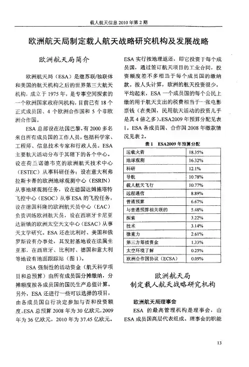
平线欧洲”“数字欧洲方案”,以及欧洲结构和
投资基金将为中小企业创造更好的发展机会。
打造共同欧洲数据空间
作为数据治理框架和相关措施的补充,
欧盟将推动在战略经济部门和公共利益领域
发展共同的欧洲数据空间。
除已有的欧洲开放
科学云外,欧盟还将支持建设覆盖工业(制造
业)、绿色协议(环保)、移动、卫生、金融、能
源、农业、公共管理、技能等九大领域的数据空
间,文件中详细介绍了每个数据空间的政策法
规背景、建设规模和时间表等情况。
这些数据
空间将提供大量数据池,以及支持数据使用和
交换的配套工具和基础设施,从而为在不同部
门复制相同的治理概念和模型提供支撑。
采取开放积极的国际化策略
欧盟将坚持核心价值观,积极参与国际
合作,不断扩大国际影响力。
一是促进和保护
欧盟数据处理规则和标准,维护欧洲企业的
权益,促进可信国家间的数据传输和共享。
二
是构建欧洲数据流量分析框架(2021年第4季
度),为欧盟数据处理部门提供分析工具,支
撑相关政策制定和反应。
三是依托有效的数据
监管和政策框架,吸引其他国家和地区的数据58软件和集成电路S OFTWARE A ND I NTEGRATED C IRCUIT。


完整版)国内外城市地下空间开发利用现状及发展趋势国内外城市地下空间的开发利用现状及发展趋势1.国外城市地下空间开发利用现状及发展趋势自1863年英国伦敦建成第一条地下铁道以来,现代城市地下空间的开发利用进入了一个高峰期。
20世纪后,大城市陆续修建了地下铁道,改善了城市交通服务,促进了商业的繁荣。
然而,从七十年代中期起,发展势头渐趋平缓。
现在,国外城市地下空间的开发利用主要基于经济、地理、社会和城市等方面的因素。
1.1 国外城市地下空间开发利用现状发达国家如日本、美国、欧洲等在城市地下空间的开发利用方面成就较高。
1.1.1 日本城市地下空间开发利用现状日本国土狭小,城市用地紧张,因此地下空间的综合利用比北欧等国家起步较晚。
但是,日本已经居世界领先地位,建设了许多地下街道、地下车站、地下铁道和地下商场。
其中,地下商业街的规模越来越大,设计指标越来越高,抗灾能力也越来越强。
同时,国家已经形成了一整套较健全的地下商业规划和设计质量方面的法规。
1.1.2 美国城市地下空间开发利用现状美国的城市地下空间开发利用主要集中在大城市的市中心区域。
其中,纽约市的地下空间利用最为广泛,包括地下铁道、地下商场、地下停车场等。
此外,美国在地下空间的利用方面也有一些创新,如在旧金山建设了地下水库,以储存城市的饮用水。
1.1.3 欧洲城市地下空间开发利用现状欧洲的城市地下空间开发利用主要集中在北欧国家和瑞士等地。
这些国家的气候寒冷,因此广泛的城市地下空间开发形成了一个四季温暖的地下世界。
在城市中心区域,地下商业街、地下车站等设施也很常见。
同时,欧洲在地下空间的利用方面也有一些创新,如在瑞士的洛桑市建设了地下垃圾处理站,以解决城市的垃圾处理问题。
2.国内城市地下空间开发利用现状及发展趋势国内城市地下空间的开发利用起步较晚,但是在近年来也有了一些进展。
目前,国内城市地下空间的开发利用主要集中在大城市的市中心区域,包括地下商业街、地下车站、地下停车场等。

!""! ’欧 洲 航 空 航 天 事 业 发 展 展 望盟委员会主席普罗迪递交了欧洲航空航天发展展 望报告,即《!( 世纪航空航天发展战略回顾》,对欧 洲在航空航天事业的发展进行了分析和展望并提 出了建议。
报告的基本内容() 报告的四个要点!航空航天的发展对满足欧洲经济增长、安全 和生活质量起着决定性作用,并直接联系和影响 欧洲的贸易、交通、环境以及安全和防务。
" 建立一个强大的和在全球具有竞争力的工 业基础为欧洲在国际舞台上施加影响提供后盾。
# 欧洲的航空航天工业如果要在全球市场上 作为工业伙伴起重要作用,必须保持强大的竞争 地位。
$ 欧洲如果要发展具有创新和竞争的航空航 天工业,就必须在关键技术上保持领先。
!) 报告建议! 在全球范围内与美国工业平等竞争。
要求 欧盟各国政府必须重视为技术开发能力的提高创 造条件。
·确保在各层次上欧洲在世界市场的公平竞 争;·提高对世界市场的准入,特别是美国市场; ·寻求更广泛的协议以简化含有美国部件的 出口控制;·确保公平的相互市场准入; ·继续发展国际合作计划。
" 强调对研究和开发的支持是保证欧洲工业 的成功和竞争力的基础。
欧洲各国政府有必要进 行相互协调,以避免分散和重复,必须增加科研经 费的投入。
·欧洲竞争政策的制定应该继续考虑空间和 国防的发展和需要;·应该分析世界范围不同的税收对促进创新 的影响,应该考虑在欧洲范围应用税收和其他优 惠政策的可能性,必要的时候可通过国家协调行 动以避免不必要的内部竞争;·应该对长期技能劳动力的教育和培训给予 认可;姜 山 梁 洪 波·应该鼓励跨边境的职员流动,克服目前存在 的,特别是有关社会安全体系和安全申报程序的 问题;·在可准入的国家内应开发切实可行的培训 体系,以促进工业的整合; ·民航关键控股者必须确定长远的研究优先 领域。

《大伦敦空间发展战略》简介Ⅰ发帖人: lily0954 点击率: 3001倍受关注的新一轮大伦敦规划——《大伦敦空间发展战略》的编制工作已经完成,于2004年2月由大伦敦政府(The Greater London Authority,简称GLA)正式向全社会颁布。
这是一个针对大伦敦地区未来30年的发展而制订的战略发展规划,发布后在英国社会各界以及国际规划界产生了较大影响。
本文简要介绍该规划的制订过程、工作背景、规划目标、发展策略要点以及规划的实施机制等内容,以期大家对新一轮的大伦敦规划有一个概要认识和了解,并对目前开展的各项规划编制和研究工作有所启示。
1、规划的制订过程在过去的30年中,英国和伦敦地区的区域规划编制与管理体制经历了一个曲折多变的发展过程。
1999年通过的大伦敦政府法(GLAA)重新确立了大伦敦政府(GLA)的合法地位授权,GLA由直选的市长和独立选举的议会构成,职权覆盖大伦敦地区的32个市级自治区和伦敦共同体。
GLAA同时授权大伦敦市的市长组织编制新一轮的大伦敦战略规划,并取代原有的伦敦发展策略指引(RPG3),以指导和协调大伦敦下属32个自治区的地方性规划,实现大伦敦地区发展的协调与合作。
《大伦敦空间发展战略》正是在此政治背景下展开。
与此同时,大伦敦政府还组织编制了有关伦敦未来发展的多个专项策略,诸如经济发展、交通、文化、能源、环境、投资、社会公平等多方面的发展策略。
这些策略都围绕着共同的三个主题:伦敦居民的健康、获得机会的平等性、对英国可持续发展所做的贡献。
这些策略的制订必须相互协调,而《大伦敦空间发展战略》将提供一个更高层次的空间发展框架,对这些策略予以整合。
同时,大伦敦规划还需要综合考虑与《欧洲空间发展展望》以及欧盟的其他发展指引协调。
按照法定要求,大伦敦规划草案必须经过可持续发展的评估。
本次大伦敦规划的编制是一个开放性的工作过程。
在规划编制工作的第一阶段,于2001年5月举行了对大伦敦规划的公众意见咨询,作为规划草案编制的参考依据。
欧洲空间发展战略European Spatial Development PerspectiveESDPEuropean Spatial Development PerspectiveTowards Balanced and Sustainable Development of the Territory of the European Union欧洲空间发展战略寻求欧盟地域范围内平衡的和可持续的发展由空间规划部长非正式会议通过1999年5月于波茨坦欧洲委员会发布目录Part A寻求欧盟地域范围内平衡的和可持续的发展:空间发展政策的作用1 欧洲层面上的空间策略PDF阅读1.1 “地域”(Territory):欧洲政策的一个新空间维度1.2 空间发展差异1.3 ESDP的基本目标1.4 ESDP的地位1.5 ESDP作为一个过程2 欧盟政策对地域的影响PDF阅读2.1 欧盟空间政策的影响日趋增强2.2 具有空间影响的欧盟政策2.2.1 竞争政策2.2.2 泛欧网络(TEN)2.2.3 结构基金(Structural Funds)2.2.4 共同农业政策2.2.5 环境政策2.2.6 研究和技术开发(RTD)2.2.7 欧洲投资银行的贷款活动2.3 推进空间整合的共同体政策3 欧盟地域的政策目标与政策选择PDF阅读3.1 政策的空间定位3.2 多中心空间发展与新型城乡关系3.2.1 欧盟多中心与均衡的空间发展3.2.2 动态的、富有吸引力和竞争力的城市与城市化区域3.2.3 本土化、多样化与高效发展的乡村地区3.2.4 城乡合作伙伴关系3.3 平等获得基础设施和知识3.3.1 改善交通条件和获得知识的综合手段3.3.2 多中心发展模式:提高可达性3.3.3 基础设施的高效与可持续利用3.3.4 创新与知识传播的基础3.4 自然与文化遗产的明智管理3.4.1 作为可利用资源的自然与文化遗产3.4.2 自然遗产的保护与开发3.4.3 水资源管理——空间发展的一个特殊挑战3.4.4 富于创造性的文化景观管理3.4.5 富于创造性的文化遗产管理4 ESDP的实施PDF阅读4.1 寻求整体性的空间发展4.2 ESDP在共同体层面的实施4.3 各成员国之间的跨国合作4.4 跨境合作和区域间合作4.5 ESDP在成员国中的实施4.6 ESDP对泛欧合作和国际合作的重要性5 欧盟的扩展:对欧洲空间发展政策提出的新挑战PDF阅读5.1 ESDP覆盖的新地域5.2 新加入国家空间发展的主要特点5.2.1 人口5.2.2 经济5.2.3 交通5.2.4 环境5.2.5 结论5.3 在未来成员国中欧洲空间发展政策的具体任务5.4 扩展对于欧盟区域的空间影响5.5 有关欧盟扩张的ESDP政策目标与选择5.6 将欧盟扩展融入欧洲空间发展和规划的原则Part B欧盟地域:趋势,机会和挑战1 欧盟空间发展现状及趋势PDF阅读1.1 欧盟的地理特征1.2 人口发展趋势1.3 经济发展趋势1.4 环境发展趋势2 对欧洲具有重要意义的空间发展问题PDF阅读2.1 欧洲城市体系的变化趋势2.1.1 城市网络的形成2.1.2 城市经济机遇的变化2.1.3 持续的城市蔓延2.1.4 城市社会分化现象加剧2.1.5 提高城市环境质量2.2 乡村地区角色和功能的变化2.2.1 城市和乡村地区之间的相互依赖性日益增强2.2.2 乡村地区发展的不同路线2.2.3 农业和林业的变化——经济发展和土地利用的结果2.3 交通与网络2.3.1 网络的界限与整合问题2.3.2 交通流量和拥堵的增加2.3.3欧盟在可达性方面存在的缺陷2.3.4 聚集和发展走廊2.3.5 在创新与知识传播方面表现出的不均衡2.4 自然和文化遗产2.4.1 生态多样性和自然区域2.4.2 对水资源的威胁2.4.3 对于文化景观的压力在持续增长2.4.4 对于文化遗产的压力在增加3 空间整合发展计划和远景PDF阅读3.1 具有空间影响的欧盟计划3.2 INTERREG II C创新计划3.3 欧洲区域发展基金(ERDF)第10条中的跨国空间发展试点行动3.4 空间发展远景4 欧盟新加入国家和成员国基础数据PDF阅读注释PDF阅读后记PDF阅读ESDP欧洲空间发展战略寻求欧盟地域范围内平衡的和可持续的发展(1)欧盟成员国负责空间规划的部长们以及负责区域政策的欧洲委员会成员在波茨坦共同强调,有关欧洲空间发展战略(ESDP)的政治讨论对于欧洲一体化进程是一个非常重要的步骤。
欧盟委员会:欧洲数据战略中文版欧洲数据战略本文由:CIE智库翻译2020年2月19日,欧盟委员会发布《欧洲数据战略》(AEuropeanStrategyfordata),全文包括背景介绍、关键点、愿景、问题、战略、国际路径、结论以及附录(欧洲战略部门和公共利益领域公共数据空间创建计划)等八个部分。
欧盟的战略目标是确保欧盟成为数据驱动型社会的榜样和领导者,以便商业和公共部门能利用数据更好地进行决策。
为了实现这一目标,欧盟必须在数据保护、公民基本权利、安全和网络安全等方面构建完善的法律框架,并建立欧盟内部市场,汇聚各种规模和不同行业基础的有竞争力的公司。
为了在数据经济中跻身世界领先地位,欧盟必须立即有所行动,通过跟各成员国协商的方式,有效解决互联互通、数据存储、数据处理、计算能力和网络安全等一系列问题。
此外,欧盟还必须进一步完善治理架构用于处理数据,并增加可供使用和重用的高质量数据库的数量。
欧盟的最终目标在于更好地利用数据造福社会,其中包括提升生产效率、构建自由竞争的市场、改善公民的健康状况,同时加强环境保护、提升治理的透明度并为公民提供更加便利的公共服务。
本文提出的政策措施有助于全面推动和促进欧盟数据经济的发展,从而增加并扩大欧盟单一市场中数据以及数字化产品的服务需求和应用规模。
该数据战略概述了欧盟未来五年实现数据经济所需的政策措施和投资策略。
欧盟委员会的目标是创建一个单一数据空间——一个真正的数据单一市场且面向世界开放,其中个人和非个人数据(包括敏感的业务数据)都是安全的,企业也可以轻松访问无限的高质量工业数据,并利用数据促进经济增长、创造价值,同时最大程度地减少人为碳排放和环境破坏。
CIE智库对战略全文进行了翻译,并总结战略的重点措施如下:欧洲数据战略。
欧洲城市空间发展与规划作为历史悠久、文化繁荣的大陆之一,欧洲拥有众多吸引人的城市。
这些城市不仅有着丰富的历史和文化遗产,还展示了不同的城市规划和空间发展模式。
欧洲城市的空间发展与规划非常重要,它直接影响着城市的可持续发展和居民的生活质量。
首先,欧洲城市空间发展与规划需要考虑社会和经济需求。
城市在不断发展变化的同时,也面临着人口增长、资源有限等问题。
因此,欧洲城市规划师不仅需要关注城市面貌的塑造,还要思考如何满足居民的需求。
比如,一些欧洲城市采取了可持续发展的理念,在城市规划中注重提供公共交通系统、绿色空间和低碳建筑,以减少交通拥堵和环境污染。
其次,欧洲城市空间发展与规划还与城市的历史和文化密不可分。
许多欧洲城市拥有悠久的历史和文化传统,它们的城市规划往往需要保留历史遗迹和传统建筑。
例如,巴黎的巴黎圣母院和埃菲尔铁塔等建筑是该市宝贵的文化财富,规划师们需要在城市发展中保护这些遗产,并合理利用空间,以保持城市的独特魅力。
在欧洲城市空间规划中,城市的可达性和可持续性也是重要考量因素。
欧洲城市规划师倾向于在城市中心建设多功能区域,以便居民生活和办公的便利性。
此外,欧洲城市通常鼓励人们步行、骑自行车或乘坐公共交通工具出行,以减少交通堵塞和环境污染。
因此,城市规划师会合理布局公共交通网络,确保居民能够轻松进出城市中心。
再者,欧洲的城市规划也注重保护和提升自然环境。
许多欧洲城市都位于自然风景秀丽的地区,城市规划不仅要保护自然资源,还要提供合适的休闲和娱乐场所。
为此,城市规划师会在城市中创建公园和绿地,以供人们休息和娱乐。
例如,阿姆斯特丹的公园与运河系统就为居民提供了独特的户外休闲环境。
最后,欧洲城市空间发展与规划还需要考虑社会公平和包容性。
城市规划师在制定城市规划方案时要确保不同社会群体都能享受到城市的公共服务和基础设施。
这意味着规划师需要合理布局住房、教育、医疗等设施,并提供适当的交通接驳和便利设施,以确保所有人的需求得到满足。
欧洲新空间战略规划对“空间”和“地方”概念的处理①The Treatment of Space and Place in the New Strategic Spatial Planning in Europe帕齐·希利著王红扬马璇译作者:帕齐·希利(Patsy Healey),参见第4页作者简介。
patsyhealey@译者:王红扬,南京大学城市与区域规划系。
hongyang_nj@马璇,南京大学城市与区域规划系。
欧洲背景下空间战略规划的复苏本文重点研究在欧洲新一轮空间战略规划中对空间(space)和地方(place)概念的处理,并将这一研究置于社会、人文科学中相关争论的背景之下。
1980年代,欧洲许多地区空间或国土规划的开展,使得城市与区域战略发展的概念少人问津;取而代之的,是更加关注和强调与城市景观更新和转型相关的大型项目,在理论支持上的表现,则是对早期的规划空间战略组织理念有所突破(Healey等, 1997; Salet和Faludi, 2000; Albrechts等, 2001; Balducci, 2001)。
但到了千年之末,空间战略规划及其各类框架、理论又在欧洲规划政策圈中重新变得时髦起来,并且得到欧盟的积极推动(CSD, 1999; Salet 和Faludi, 2000; Albrechts等, 2001; Faludi, 2002; Faludi和Waterhout, 2002)。
对空间战略规划兴趣的复苏有很多原因,其中包括一直存在于地方层面的协调公共政策的难题;寻求如何使城市区域通过发展共同的“竞争优势基础”,从而在经济上更具竞争力;寻求更有利于实现“可持续发展”目标(一般包含很多分散目标)的空间形态与关系;以及到了最近,对纠正城市区域中不同群体发展机会不平等问题的关心,人们意识到这些群体在地方上是共存的。
空间战略规划或许还扮演了一定的政治角色,加强了在“多层级”管治格局中城市政府和区域机构的声音,这一点在20世纪末期的欧洲已经得到了广泛的认同(Hooghe, 1996; Cookeet等, 2000)。
第27卷 第6期2008年11月地 理 研 究GEOGRAPH ICAL RESEARCH V o l 27,N o 6N ov ,2008收稿日期:2008 03 29;修订日期:2008 06 23基金项目:国家自然科学基金重点项目(40830741);中国科学院知识创新工程重要方向性项目(KZCW 2 YW 322) 作者简介:刘慧(1964 ),女,副研究员。
主要从事区域发展问题研究。
E m ail:liuh@igsn rr ac cn欧盟空间规划研究进展及启示刘 慧,樊 杰,王传胜(中国科学院地理科学与资源研究所,北京100101)摘要:欧盟空间规划是世界上最早的跨国空间规划。
其新的空间规划理念、跨国规划实践、新的规划方法与制度等,在世界空间规划领域产生了较大的影响。
欧盟从上世纪80年代以来先后启动实施了欧洲标准区域划分(NU T S)、欧洲空间发展远景(ESDP )和欧洲空间规划研究计划(SPESP)等3个不同的空间规划研究项目,在空间规划理念、空间区域划分等方面取得了重要的研究成果。
此外,欧洲区域发展基金、欧洲社会基金、结构基金以及监测评估网络的建立,是欧盟空间规划实施的重要政策保障体系。
文章最后进一步探讨了欧盟空间规划实践对我国当前空间规划研究的若干启示。
关键词:欧盟;空间规划;政策体系;启示文章编号:1000 0585(2008)06 1381 09欧盟(EU)的前身是1958年建立的欧洲经济共同体(EEC),其区域和环境政策均具有广泛的空间影响力。
80年代后期以来,随着欧洲单一市场的出现,全球化对空间发展模式的影响越来越大,欧盟成员国内城市与区域同时表现出更多的依赖和竞争。
这种竞争可能导致空间发展的不平衡,威胁欧洲社会和经济的融合。
90年代以后,欧盟范围东扩,使欧盟内部区域不平衡性加剧,阻碍了区域平衡和可持续的空间发展。
多数成员国之间的区域差异增加。
这违背了欧盟一体化规章中规定的欧盟地域内均衡发展的最高目标。
——1No.200711〔6〕 日期:2007-11-14上海同济城市规划设计研究院 科研部欧洲空间发展战略(ESDP )寻求欧盟地域范围内平衡的和可持续的发展(1)欧盟成员国负责空间规划的部长们以及负责区域政策的欧洲委员会成员在波茨坦共同强调,有关欧洲空间发展战略(ESDP )的政治讨论对于欧洲一体化进程是一个非常重要的步骤。
(2)通过制定ESDP ,成员国和欧洲委员会形成了有关欧盟地域未来发展的共同目标和概念。
(3)制定空间发展政策的目的是为了寻求欧盟地域范围内平衡的和可持续的发展。
以部长们的观点来看,重要的是要保证欧洲政策的三个基本目标在欧盟每个区域中都得到公平实现: ·经济和社会整合;·自然资源和文化遗产的保护和管理; ·实现欧洲地域范围内更加平衡的竞争态势。
ESDP 为共同体和欧盟成员国内具有空间影响的部门政策提供了一个非常适当的政策框架,同时也为区域和地方有关部门寻求平衡的和可持续的发展提供了指导。
(4)为了欧洲的整体利益,部长们认为在成员国之间以及在它们的区域和地方机构之间就区域发展进行合作是非常必要的,区域和地方机构在未来必须跨越国家界限协力合作。
ESDP 为推动这种合作提供了一份非常有价值的参考文件,同时也体现了对辅助性原则(the principle of subsidiarity )的尊重。
(5)所有的与会者都同意ESDP 不提供共同体层面上的任何新职责,它只作为向成员国提供的一个政策框架,各成员国的区域和地方机构以及欧洲委员会都有各自的职责范围。
引自欧盟空间规划部长非正式会议(德国轮值)最终决议波茨坦,1999年5月10―11日— —2No.200711〔6〕 日期:2007-11-14上海同济城市规划设计研究院 科研部ESDPEuropean Spatial Development PerspectiveTowards Balanced and Sustainable Development of the Territory of the European Union 欧洲空间发展战略寻求欧盟地域范围内平衡的和可持续的发展 由空间规划部长非正式会议通过 1999年5月于波茨坦 欧洲委员会发布目 录Part A寻求欧盟地域范围内平衡的和可持续的发展:空间发展政策的作用1 欧洲层面上的空间策略1.1 “地域”(Territory ):欧洲政策的一个新空间维度 1.2 空间发展差异 1.3 ESDP 的基本目标 1.4 ESDP 的地位 1.5 ESDP 作为一个过程 2 欧盟政策对地域的影响2.1 欧盟空间政策的影响日趋增强 2.2 具有空间影响的欧盟政策——3No.200711〔6〕 日期:2007-11-14上海同济城市规划设计研究院 科研部2.2.1 竞争政策 2.2.2 泛欧网络(TEN )2.2.3 结构基金(Structural Funds ) 2.2.4 共同农业政策 2.2.5 环境政策2.2.6 研究和技术开发(RTD ) 2.2.7 欧洲投资银行的贷款活动 2.3 推进空间整合的共同体政策3 欧盟地域的政策目标与政策选择 3.1 政策的空间定位3.2 多中心空间发展与新型城乡关系 3.2.1 欧盟多中心与均衡的空间发展3.2.2 动态的、富有吸引力和竞争力的城市与城市化区域 3.2.3 本土化、多样化与高效发展的乡村地区 3.2.4 城乡合作伙伴关系 3.3 平等获得基础设施和知识3.3.1 改善交通条件和获得知识的综合手段 3.3.2 多中心发展模式:提高可达性 3.3.3 基础设施的高效与可持续利用 3.3.4 创新与知识传播的基础 3.4 自然与文化遗产的明智管理 3.4.1 作为可利用资源的自然与文化遗产 3.4.2 自然遗产的保护与开发3.4.3 水资源管理——空间发展的一个特殊挑战— —4No.200711〔6〕 日期:2007-11-14上海同济城市规划设计研究院 科研部3.4.4 富于创造性的文化景观管理 3.4.5 富于创造性的文化遗产管理4 ESDP 的实施4.1 寻求整体性的空间发展 4.2 ESDP 在共同体层面的实施 4.3 各成员国之间的跨国合作 4.4 跨境合作和区域间合作 4.5 ESDP 在成员国中的实施4.6 ESDP 对泛欧合作和国际合作的重要性5 欧盟的扩展:对欧洲空间发展政策提出的新挑战 5.1 ESDP 覆盖的新地域5.2 新加入国家空间发展的主要特点 5.2.1 人口 5.2.2 经济 5.2.3 交通 5.2.4 环境 5.2.5 结论5.3 在未来成员国中欧洲空间发展政策的具体任务 5.4 扩展对于欧盟区域的空间影响5.5 有关欧盟扩张的ESDP 政策目标与选择 5.6 将欧盟扩展融入欧洲空间发展和规划的原则— —5No.200711〔6〕 日期:2007-11-14上海同济城市规划设计研究院 科研部Part B欧盟地域:趋势,机会和挑战1 欧盟空间发展现状及趋势 1.1 欧盟的地理特征 1.2 人口发展趋势 1.3 经济发展趋势 1.4 环境发展趋势2 对欧洲具有重要意义的空间发展问题 2.1 欧洲城市体系的变化趋势 2.1.1 城市网络的形成 2.1.2 城市经济机遇的变化 2.1.3 持续的城市蔓延 2.1.4 城市社会分化现象加剧 2.1.5 提高城市环境质量 2.2 乡村地区角色和功能的变化2.2.1 城市和乡村地区之间的相互依赖性日益增强 2.2.2 乡村地区发展的不同路线2.2.3 农业和林业的变化——经济发展和土地利用的结果 2.3 交通与网络2.3.1 网络的界限与整合问题 2.3.2 交通流量和拥堵的增加 2.3.3欧盟在可达性方面存在的缺陷 2.3.4 聚集和发展走廊——6No.200711〔6〕 日期:2007-11-14上海同济城市规划设计研究院 科研部2.3.5 在创新与知识传播方面表现出的不均衡 2.4 自然和文化遗产 2.4.1 生态多样性和自然区域 2.4.2 对水资源的威胁2.4.3 对于文化景观的压力在持续增长 2.4.4 对于文化遗产的压力在增加3 空间整合发展计划和远景 3.1 具有空间影响的欧盟计划 3.2 INTERREG II C 创新计划3.3 欧洲区域发展基金(ERDF )第10条中的跨国空间发展试点行动 3.4 空间发展远景4 欧盟新加入国家和成员国基础数据 注释 后记1 欧洲层面上的空间策略1.1 “地域”(Territory):欧洲政策的一个新空间维度(1)欧盟(EU)具有明显的地域特征,即在面积不大的地域范围内集聚了多种文化。
这一特征使欧盟与世界上其它大型经济区域有所不同,如美国、日本和南美共同市场(MERCOSUR)[1]等。
这种多样性是推动欧盟发展的最重要因素之一,必须在欧洲整合过程中予以保留。
因此,空间发展政策不能将欧盟范围内的地方和区域特质标准化,因为这些特质将有助于提升当地居民的生活品质。
(2)自从欧洲经济与货币组织(EMU)成立以来,欧洲的整合过程有了显著的进展[2]。
随着经济和社会整合的展开,内部边界的分割特征逐渐消失,成员国的各个城市和区域之间的联系和相互依赖关系不断加强。
这就意味着在某个国家内,区域性、国家性或共同体的项目可能会对其他成员国的空间结构产生明显的影响。
在未来实施共同体政策时,应该在较早阶段给予空间因素以更多的关注,尤其是因为现在已不再可能通过调整汇率来平衡区域生产力的差异。
就这点来说,空间规划有助于避免这种区域不平衡的加剧。
(3)如果以一个共同的目标来引导成员国的空间发展,那么在不同成员国中的发展项目就能够以最好的方式相互补充。
因此,成员国各自的国家空间发展政策和欧盟的产业部门政策就需要有清晰的、在空间层面上具有前瞻性的发展导则。
在欧洲委员会的协作下,由成员国草拟的欧洲空间发展战略(ESDP)包含了这些发展导则。
(4)欧洲单一市场(Single European Market)内部的竞争是促进欧盟空间发展的驱动力之一,这种竞争将由于欧洲经济与货币组织政策的推行而变得更加激烈。
即使区域、城市和地方当局已经在多个领域开展了合作,他们还是要在经济活动、就业岗位和基础设施方面相互竞争。
然而,在目前并不是所有的欧洲区域都站在同一条起跑线上,这就使得实现欧盟经济和社会整合过程复杂化。
因而,以空间平衡为目标显得越来越重要,这一目标旨在实现欧盟地域范围内地理上更加均衡的发展(以协调为目标)。
(5)鉴于欧盟大多数区域内的劳动力市场问题严重,空间发展政策必须确保那些能为本地居民持续提供新就业岗位的目标。
只有区域劳动力市场更加平衡,当地居民才能够全身心地投入去塑造自己的生活,并在自己的区域内以一种积极的方式体验欧洲整合带来的好处。
(6)影响欧盟长远空间发展趋势的三个主要因素是:▪经济整合的进展和相关成员国之间合作的强化;▪地方和区域共同体重要性的提升及其在空间发展中的作用;▪欧盟在预期中的扩大以及欧盟与其近邻关系的密切程度。
这三个发展因素必须被放置到全球经济和技术发展的大背景中,并通过总的人口、社会和生态趋势来进行考察。
如果运用得当,这些因素将为提高欧洲地区的协调发展提供一个框架。
(7)在未来,欧盟的空间发展问题只能够通过不同的政府和管理层之间的合作来解决。
随着欧洲整合的启动,各个层面的关系都在逐渐密切:包括区域之间的关系、区域与国家和欧洲各主管机构之间的关系。
城市与区域之间更加相互依赖,不管是在全球发展趋势还是在共同体的决策层面上都是如此。
通过鼓励城市与区域的参与,欧洲整合的过程可以促进空间发展。
(8)为扩展新视野,ESDP提供了跨部门政策措施的方法,它重点关注欧洲地域范围内的整体情况,并综合考虑对个体区域具有意义的发展机会。
在ESDP中提出的新形式的合作,当它们对同一个地域产生影响时,应该有助于促成部门政策之间的协调,而这些部门政策目前仍被独立地实施。
欧共体还要求城市和区域的积极合作,特别是能够以一种对地方居民友好的方式来实现欧盟的目标,这也是欧盟条约补充性原则得以实现的根本。
1.2 空间发展差异(9)欧盟拥有320万平方公里的疆域,超过 3.7亿居民,年均国内生产总值(GDP)为6.8万亿埃居(ECU,欧洲货币单位),使欧盟成为世界上最大和经济上最强的区域之一[3]。
(10)然而,欧盟内部存在着严重的经济不平衡,阻碍了区域平衡的和可持续的空间发展。
下面描述了有关经济潜力的不平衡分布(见地图1)。
欧盟的中心地区,包括伦敦、巴黎、米兰、慕尼黑和汉堡等大都市在内,容纳了占欧盟将近40%的人口,创造了占欧盟50%的GDP,覆盖了欧盟20%的疆域[4]。