
测绘专业英语_距离测量
- 格式:ppt
- 大小:557.00 KB
- 文档页数:12

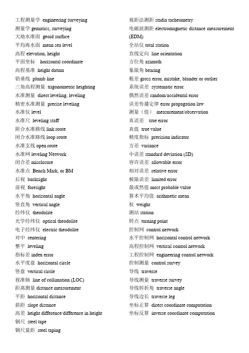
工程测量学engineering surveying测量学gematics, surveying大地水准面geoid surface平均海水面mean sea level高程elevation, height平面坐标horizontal coordinate高程基准height datum铅垂线plumb line三角高程测量trigonometric heighting水准测量direct leveling, leveling精密水准测量precise leveling水准仪level水准尺leveling staff附合水准路线link route闭合水准路线loop route水准支线open route水准网leveling Network闭合差misclosure水准点Bench Mark, or BM后视backsight前视foresight水平角horizontal angle竖直角vertical angle经纬仪theodolite光学经纬仪optical theodolite电子经纬仪electric theodolite对中centering整平leveling指标差index error水平度盘horizontal circle竖盘vertical circle视准轴line of collimation (LOC)距离测量distance measurement平距horizontal distance斜距slope distance高差height difference/difference in height 钢尺steel tape钢尺量距steel taping 视距法测距stadia tacheometry电磁波测距electromagnetic distance measurement (EDM)全站仪total station直线定向line orientation方位角azimuth象限角bearing粗差gross error, mistake, blunder or outlier系统误差systematic error偶然误差random/accidental error误差传播定律error propagation law测量(值)measurement/observation真误差true error真值true value精度指标precision indicator方差variance中误差standard deviation (SD)容许误差allowable error相对误差relative error极限误差limited error最或然值most probable value算术平均值arithmetic mean权weight测站station转点turning point控制网control network水平控制网horizontal control network高程控制网vertical control network工程控制网engineering control network控制测量control survey导线traverse导线测量traverse survey导线转折角traverse angle导线边长traverse leg坐标正算direct coordinate computation坐标反算inverse coordinate computation。

测绘工程专业英语翻译Uuit1 What is Geomatics? (什么是测绘学) 2 Unit 2 Geodetic Surveying and Plane Surveying(大地测量与平面测量)7 Unit 3 Distance Measurement(距离测量)12 Unit 4 Angle and Direction Measurement(角度和方向测量)15 Unit 5 Traversing (导线测量)18 Unit 6 Methods of Elevation Determination(高程测量方法)22 Unit 7 Robotic Total Station (智能型全站仪)26 Unit8 Errors in Measurement(测量工作中的误差)30Uuit1 What is Geomatics? (什么是测绘学)Geomatics Defined(测绘学定义)Where does the word Geomatics come from?(Geomatics-测绘或地球空间信息学,这个名词是怎么来的呢?)GEODESY+GEOINFORMATICS=GEOMATICS or GEO- for earth and – MATICS for mathematical or GEO- for Geoscience and -MATICS for informatics. (大地测量学+地理信息学=GEOMATICS 测绘学或者geo 代表地球,matics 代表数学,或者geo 代表地球科学,matics 代表信息学)It has been said that geomatics is many things to many people.(据说测绘学这个词对不同的人有不同的理解)The term geomatics emerged first in Canada and as an academic discipline; it has been introduced worldwide in a number of institutes of higher education during the past few years, mostly by renaming what was previously called “geodesy” or “surveying”, and by adding a number of computer scienceand/or GIS-oriented courses.(这个术语【term 术语】作为一个学科【academic discipline 学科】第一次形成【emerge】于加拿大;在过去的几年里被全世界的许多高等教育研究机构所熟知,通常是以前的“大地测量学” 或“测量学”在引入了许多计算机科学和GIS 方向【或“基于GIS” 】的课程后重新命名的。

测绘专业英语词汇及名词解释测绘学:geomatics, surveying and mapping, SM;研究与地球有关的基础空间信息的采集、处理、显示、管理、利用的科学与技术。
中华人民共和国测绘法:Surveying and Mapping Law of the People's Republic of China;我国关于测绘的基本法律,是从事测绘活动和进行测绘管理的基本准则和基本依据。
测绘标准:standards of surveying and mapping;由主管部门颁发的关于测绘技术方法、产品质量、品种规格、地图表示等统一规定的技术文件。
测量规范:specifications of surveys;对测量产品的质量、规格以及测量作业中的技术事项所作的统一规定。
地形图图式:topographic map symbols;对地图上地物、地貌符号的样式、规格、颜色、使用以及地图注记和图廓整饰等所作的统一规定。
大地测量学:geodesy;研究和确定地球的形状、大小、重力场、整体与局部运动和地表面点的几何位置以及它们的变化的理论和技术的学科。
地球形状:earth, shape, figure of the earth;地球自然表面的形状或大地水准面的形状。
重力基准:gravity datum;重力的起算值和尺度因子。
重力场:gravity field;地球重力作用的空间。
在该空间中,每一点都有惟一的一个重力矢量与之相对应。
地心坐标系:geocentric coordinate system;以地球质心或几何中心为原点的坐标系。
地球椭球:earth ellipsoid;近似表示地球的形状和大小,并且其表面为等位面的旋转椭球。
大地原点:geodetic origin;大地坐标的起算点。
水准原点:leveling origin;高程起算的基准点。
测量标志:survey mark;标定地面测量控制点位置的标石、觇标以及其他用于测量的标记物的通称。

一、名词解释:1、Surveying (测量学)is the art of making such measurements of the relative positions of points on the surface of Earth that,on drawing them to scale natural and artificial features may be exhibited in their correct horizontal or vertical relationships.2、Plane surveying (平面测量)is of wide scope and utility,and its methods are e mployed in the vast majorit y of surveys undertaken for various purposes,such as en gineering ,architectural,legal,c ommercial,scientific,geograph ical,exploratory,military,and n avigational.3、Geodetic surveys(大地测量)are usually of a nati onal character,occasionally w orks of international coopera tion,and they are undertaken as basis for the production of accurate maps of wide areas.4、Leveling(水准测量) is t he general term applied to a ny of the various processes by which elevations of point s or differences in elevation are determined.5、The theodolite (经纬仪)is an instrument designed for the measurement of hori zontal and vertical angles.It is the most precise instrume nt available for such observ ations,and is of wide applica bility in surveying.6、A traverse(导线)is a series of consecutive lines whose lengths and directions have been determined from field measurements7、Traversing(导线测量),the act of establishing traverse stations and making the ne cessary measurements,is one of the most basic and wid ely practiced means of deter mining the relative locations of points.8、Azimuths(方位角)are measured clockwise from th e north end of the meridian through the angle points. 9、Topographic surveys(地形测量)are made to deter mine the configuration (relie f) of the earth’s surface and to locate natural and cultur al features on it.10、A topographic map(地形图)is a large scale repres entation of a portion of theEarth’s showing culture, relief, hydrography, and perhaps vegetation.11、Systematic-Error(系统误差):These-errors conformto mathematical and physical laws.Their magnitude maybe constant or variable depending on conditions.12、Radom error(偶然误差):These are errors that remain after mistakes and systematic errors have been eliminated.13、Precision(精度)refers to the degree of refinementor consistency of a group of measurements.14、Accuracy(准确度)which denotes the absolute nearness of measured quantities to their true values.二、填空1、The metal case is attached to some part of the instrument in such a way as topermit some (adjustment) of the position.2、Transits,are instrumentswhich ..... Along the verticalplane (altitude) as well asthe horizontal plane (azimuth).3、These instruments are (tripods),plane tables,(level rods),chains,and (tapes).4、As can be observed ,EDM systems are made up ofthree components-(a transmitter),(a reflector),and (a receiver).5、....the telescope must becapable of rotation about a(horizontal axis),for measurement of horizonal angles,the instrument must be rotatedabout a (vertical axis).6、There must be an (indexmark) on the rotating part,placed so that readings canbe taken against it on the(graduated circle).7、.....the observer operatesa setting device to obtain a(mean reading) free from(eccentricity error).8、If the (plumb bob) is not over the point,the (centering screw) can be loosenedand the.......9、These notes include directions.....stations with (fourdifferent positions).Two readings were taken on each position (one with the telescope normal or direct and onewith the instrument (reversed or plunged)).10、The line is determinedby a telescope with the usual components consisting of(object glass),(focusing arrangement),(diaphragm withcross-lines), and (eye-piece).11、A level fitted with (horizontal circle) and (stadia lines) can be used to make acomplete (three-dimensional) survey of a limited area round the instrument.12、Levels are used to obtain the direct measurement of (height differences)between two points.13、Which transmit either (modulated laser) or (infrared light) having wavelengths within or slightly beyondthe ......14、Which transmits (microwaves) with (frequencies) in the range of 3 to 35GHZcorresponding to wavelength of about 1.0 to 8.6 mm.15、The methods used in measuring angles or directionsof traverse lines vary,and include (compass bearings),(interior angles),(deflection angles),(angles to the right),(azimuths).16、The instrument is oriented at each station by (backsighting) on the previous point with (the back bearingset) on the plates.17、(Electronic devices) and (taping) are used most often and provide the highestorder of accuracy.18、On construction work,(allowable limits of closure)depend on the use and extent of the traverse and typeof project.Bright location, for example ,demands a highdegree of precision.19、Vertical control is provided by bench marks in or near the tract to be surveyed.It becomes the foundation for correctly portraying reliefon a map,A (vertical control net)is established by (lines of levels)starting fromand closing on bench marks.三、翻译:1、It is convenient to considerthat a bubble tube has anaxis,which may be taken as astraight line parallel to the freesurface of the liquid when thebubble is in the centralposition determined by thegraduation marks.当气泡处于分划线所确定的中心位置时,我们可以很容易想像水准管有一个轴,这个轴可以看作是一条与液体的自由表面平行的直线。