深圳市土地利用变化机制分析_史培军
- 格式:pdf
- 大小:330.90 KB
- 文档页数:10
摘要作为中国改革开放的先锋城市,深圳以先行先试率先改革的“政策特权”与城市品格,突破僵化的传统计划经济体制束缚与传统意识形态的桎梏,在土地制度改革方面进行了前所未有的探索与创新,在中国土地制度变迁的现代史中,书写了具有历史意义的篇章。
纵观深圳土地制度变迁的历史进程,其变革频率之高、方式之独特、内容之丰富都是其他城市所无法比拟的。
深圳市的土地制度改革不仅为建立适合中国国情的制度变迁理论提供了宝贵的研究素材,同时也在中国社会制度变迁中为全国提供了可借鉴、可复制的经验与模式。
如,开创了国有土地有偿使用的先河;敲响了新中国土地拍卖第一槌;通过两次集体土地国有化,成为中国首个没有农村建制的城市;率先开启了旨在提高现有存量土地使用效率的,以市场为主导的城市更新和以政府为主导的土地整备为典型代表的土地再开发利用模式等等。
但另一方面,深圳是在“摸着石头过河”中逐步开始土地制度改革实践的,由于缺乏可借鉴的经验,加之对市场经济认知的不足,尤其土地所有权本身所具有的意识形态性,所以在改革中又产生了一些历史遗留问题。
如,由于历史原因而导致的土地产权不够明晰、资源配置方式较低效以及增值收益分配不公平等。
这些历史遗留问题不仅制约着经济社会的发展,同时又构成了深化改革的内容。
由于城市自身土地面积的局限性,以及国家顶层制度设计与法律法规对地方土地制度改革的约束,深圳土地制度变迁呈现出以下特点:一是由于率先开始土地使用权拍卖和国有土地的有偿使用,从而解决了发展初期的资金约束,在特殊政策支撑下成为助力深圳经济迅速崛起的重要因素;二是由于深圳自身土地面积的局限,客观上率先进行土地制度改革的制度绩效并没有一直成为深圳经济高速发展的资源与制度支撑,土地本身成为了深圳进一步发展的短板与硬约束,但同时又促使了旨在提高现有存量土地利用的另一种改革路径的尝试与探索;三是从整体上来说,尽管深圳作为中国改革开放的先行先试的“政策增长极”率先开始了具有历史意义的土地制度的改革,但相对于其他领域的制度改革而言,土地制度改革是相对滞后的,并受到更多的制度环境的约束。
第21卷第7期2001年7月生 态 学 报A CTA ECOLO G I CA S I N I CAV o l .21,N o.7Ju l .,2001深圳市土地利用变化对流域径流的影响史培军,袁 艺,陈 晋(北京师范大学资源科学研究所,北京师范大学环境演变与自然灾害教育部重点实验室,北京,100875)基金项目:国家自然科学基金(49671001)和国家自然科学重大基金(39899374)资助项目收稿日期:2001201202;修订日期:2001204210作者简介:史培军(1959~),男,陕西靖边人,博士,教授。
主要从事区域资源开发、自然灾害、环境演变的研究。
摘要:土地利用所引起的流域下垫面变化严重影响着洪涝灾害的致灾过程。
以深圳市为例,探讨下垫面条件对流域径流过程的影响,应用美国农业部水土保持局(So il Conservati on Service )研制的小流域设计洪水模型——SCS 模型对深圳市部分流域进行了径流过程的模拟,重点分析了土地利用方式、土壤类型、前期土壤湿润程度等下垫面因素以及降雨因素对降雨2径流关系的影响。
结果表明,随着人类活动的加剧,土地利用的变化使径流量趋于增大;降雨强度越大、前期土壤湿润程度越大,土地利用变化对径流量的影响越小。
降雨2径流的空间格局随土地利用方式、土壤类型、前期土壤湿润程度而发生变化,CN 值(Curve N um ber )的高值区主要集中在城市用地和水体;低值区主要出现在林地、灌草地、果园等植被覆盖较好、地势起伏较大的地区。
关键词:土地利用变化;降雨2径流关系;SCS 模型;深圳The effect of land use on runoff i n Shenzhen C ity of Ch i naSH I Pei 2Jun ,YU AN Y i ,CH EN J in (Institu te ofR esou rces S cience ,B eij ing N or m al U niversity ;K ey L abo 2ratory of E nv ironm ental Chang e and N atu ral D isaster ,M inistry of E d ucation of Ch ina ,B eij ing N or m al U niversity ,B ei 2j ing 100875,Ch ina )Abstract :T he land cover change induced by the land u se of hum an beings is the m ain cau se and i m po rtan t part of eco 2environm en t change 1T he effect of land u se on natu ral disasters is one of the m ain p rocesses 1F lood disaster is one of the disasters ,the num ber of w h ich is mo st and the lo ss of w h ich is the mo st seri 2ou s 1T he effect of land u se on rainfall 2runoff p rocess is studied to understand the relati on sh i p betw een land u se and flood disaster 1In the flood generati on p rocess ,the effect of land u se pattern and in ten sity on runoff generati on and concen trati on is the foundati on to study the change of u rban flood cau sed by the hu 2m an activities 1R evealing the m echan is m of land u se on the flood generati on is i m po rtan t to reduce u rban flood disaster 1T he first i m po rtan t issue ,w h ich shou ld be an s w ered ,is how the land u se pattern influ 2ences the change of runoff coefficien t and the m echan is m of runoff generati on and concen trati on 1Shenzhen C ity has grow n to a modern ized city from a fishery village after it w as assigned as the first Special Econom 2ic Zone in Ch ina from 19801W ith mo re than tw en ty years econom ic refo rm and open ing ,the great changes of land u se pattern s in Shenzhen C ity are inevitab le 1So ,Shenzhen C ity is taken up as case study area to study runoff change due to land u se change 1Based on the data of land u se ,hydro logy and m eteo ro logy ,SCS model ,developed by So il Con servati on Service (SCS ),U 1S 1A 1,is app lied to study the rainfall 2runoff relati on sh i p of som e rivers in Shenzhen C ity 1T he fo llow ing is the m ain conclu si on s of the paper :(1)Basin 2scale hydro logic model is a good m ean s to study the rainfall 2runoff relati on 1R emo te 2sen s 2ing 2based hydro logic model is one of m ain develop ing directi on s of basin 2scale model in the fu tu re ,and it has a good develop ing p ro spect 1Based on the si m u lati on p rocess and resu lt ,SCS model is a good hydro log 2ic model to study the rainfall 2runoff relati on in the regi on s being sho rt of hydro logical and m eteo ro logic da 2ta 1CN value in SCS model describes the relati on sh i p betw een rainfall and runoff ,w h ich reflects the runoff © 1995-2005 Tsinghua Tongfang Optical Disc Co., Ltd. All rights reserved.generati on capab ility of underlying su rface un it in basin s 1Based on the defin iti on of SCS model ,CN value is the functi on of land u se classes ,so il classes and an teceden t mo istu re conditi on s (AM C )1Generally ,the CN value is large w h ile the runoff is large in certain underlying su rface un its 1(2)T he spatial distribu ti on of CN value is successive ,reflecting the runoff generati on capab ility of differen t underlying su rfaces in spatial pattern 1By analysing the CN con tou rs of Shenzhen C ity ,the spa 2tial distribu ti on of rainfall 2runoff relati on sh i p changes along w ith the change of land u se classes ,so il class 2es and an teceden t mo istu re conditi on s of so il 1T he regi on s of h igh values of CN are u rban and w ater 1T he regi on s of low value of CN are fo rest ,sh rub grassland and o rchard ,and the elevati on of these regi on s is comparatively h igh 1A cco rding to the spatial distribu ti on of CN con tou rs ,the land u se changes cau sed by the u rban izati on is the m ain cau se of the increase of runoff coefficien t 1(3)A cco rding to the si m u lati on resu lts of sto rm runoff in Bu ji R iver Basin (one of the m ain tribu 2taries of Shenzhen R iver ),there are som e i m po rtan t resu lts 1F irstly ,the land u se is one of the m ain fac 2to rs w h ich effect the rainfall 2runoff relati on sh i p 1T he runoff increases from 1980to 1994,and the relative increasing m agn itude ranges from 116%to 6219%1F rom 1980to 1994,the econom ic developm en t leads to the runoff coefficien t tran sfo rm ing in to h igh values 1T he increase of runoff coefficien t fo llow ing the land u se change ranges from 01021to 010751Secondly ,bo th the rainfall and the so il an teceden t mo istu re condi 2ti on influence the effect of land u se on the rainfall 2runoff relati on sh i p 1O n certain an teceden t so il mo istu re conditi on s ,the relati on sh i p betw een the change of land area of differen t runoff coefficien ts in Bu ji R iver Basin and the rainfall in ten sities is in the o rder 90%>50%>10%,nam ely the heavier the rainfall ,the lit 2tle the effect of land u se on the rainfall 2runoff relati on sh i p 1Given p reci p itati on ,the relati on sh i p betw een the change of runoff coefficien ts from 1980to 1994and the an teceden t mo istu re conditi on s is AM C I (dry conditi on )>AM C II (no rm al conditi on )>AM C III (w et conditi on ),demon strating w hen the an teceden t so il mo istu re conditi on s becom e w etter ,the land u se change has a s m aller effect on the change of the runoff 1F inally ,the changes of runoff coefficien ts in differen t ti m es are differen t along w ith the change of the rainfall in ten sities o r the change of the an teceden t so il mo istu re conditi on s of so il 1T he m ax i m um change appears in 19801T hen is 19881T he least is in 19941T he resu lts i m p ly that the land u se changing to u rban land w eaken s the effect of the rainfall in ten sity and the an teceden t so il mo istu re conditi on s on the rainfall 2runoff relati on sh i p 1Key words :land u se change ;rainfall 2runoff relati on ;SCS model ;Shenzhen C ity of Ch ina 文章编号:100020933(2001)0721041209 中图分类号:X 4 文献标识码:A 土地利用所引起的地表景观格局的变化是引起地表各种地理过程变化的主要原因,亦是区域环境演变的重要组成部分,其中土地利用对自然灾害的影响是这一过程的一种突出表现。
《深圳市建立节约集约用地长效机制研究》课题成果简介姜连馥土地在城市发展中占据着非常重要的地位,不论是基础设施建设,还是产业、人口等要素的聚集,都离不开土地这个载体。
深圳在经过30年的飞速发展后,城市化达到国内一流水平。
然而,其在快速城市化的进程中,土地与人的矛盾也日益突出,主要表现在以下两个方面:1)外延式扩张模式造成用地结构不合理。
特别是特区外发端于以村为单位的“招商引资”经济诉求的工业化和城市化,使特区外建设用地扩张呈粗放型的外延式扩张,呈现居住用地村庄化、工业布局混乱化、基础配套设施落后化的特征,而以行政村为单位、个别发展的城市扩张模式,使得深圳市内部土地单元分割破碎,资源和要素更大范围的配置与重组受到行政区划的刚性约束。
2)土地资源总量有限,后背不足。
土地供应面临数量和质量双重不足的问题,同时人口与经济的超常规增长进一步增加了土地资源的稀缺性。
土地、资源、环境和人口“四个难以为继”的制约已日益突现,其中排在首位的就是“土地空间难以为继”。
本报告拟从四个方面展开论述,试图从政府政策,深圳产业结构调整与土地供给关系,土地承载力和土地集约利用等角度来探讨深圳市土地集约利用现状和在土地资源制约下对深圳市经济可持续发展的影响,最后分析归纳到深圳具体应对策略。
1深圳市土地集约节约利用现状和利用政策深圳市在取得了每平方公里建设用地GDP产出达到5亿元、城市绿化覆盖率达到约45%、花园城市、全国环保模范城市、卫生模范城市等荣誉后,表明深圳市在节约集约利用土地、维持良好的生态环境等方面已经取得了较好成绩,但与此同时在快速城市化与工业化的过程中城市土地的低效、不协调利用问题也日益突出。
(1)城市用地规模失控城市规模的扩大是实现城市社会经济发展的客观要求,随着城市化的加速和兴建开发区的出现,深圳的很多建设都忽视了城市建设控制规划,追求过高的人口与用地规模,致使城市用地规模失控。
在过去的二十多年里,按国家土地局利用卫星资料对北京、深圳等31个特大城市的城市用地规模进行的分析,结果表明:特大城市和城区用地规模平均增长50.1%,特大城市用地规模增长弹性系数为2.29。

土地利用与土地覆被变化2012级地理科学摘要:人类活动对环境的影响越来越成为自然地理学的关注中心,其中土地利用及土地覆被变化是全球环境变化的重要环节和主要原因。
因此,国际地圈——生物圈计划(IGBP)和全球环境变化中的人文方面计划(IHDP)联合提出“土地利用和土地覆被变化”(IGBP and IHDP,1993,1995,1999)这一核心研究领域,受到社会各界的极大重视。
本文从“土地利用与土地覆被变化”的研究内容,研究案例等方面来说明。
关键词:土地利用土地覆被LUCC一、土地利用与覆被变化的概念1.土地利用的概念世界粮农组织(FAO)1985年指出:“土地利用是由自然条件与人的干涉所决定的土地功能。
”陈百明1996年将土地利用定义为“人类为了经济社会目的而进行的一系列生物和技术活动,对土地长期或周期性的经营活动”。
许炎谟和陈章琛1987年将土地利用定义成“一种社会经济现象,是人类在漫长的历史过程中对土地资源进行持续开发和改造治理的结果”。
综上所述,土地利用是指人类有目的地开发利用土地资源的一切活动,如农业用地、林业用地、工业用地、交通用地、居住用地、休闲娱乐用地等都是不同的土地利用类型。
2.土地覆被变化的概念美国“全球变化研究计划”将土地覆被定义为“覆盖着地球表面的植被及其他特质”;摆万奇等将土地覆被定义为“覆盖地面的自然物体和人工建筑物,它反映的是地球表层的自然状态”;还有学者将土地覆被定义为“地球表面当前所具有的自然和人为影响所形成的覆被物,包括地表植被、土壤、冰川、湖泊、沼泽、湿地及道路等”和“土地覆被是随着遥感技术的应用而出现的新概念,是指覆被地面的自然物体和人工建筑物,最主要的组成部分是植被,也包括土壤和陆地表面的水体”。
总之,土地利用是指人类有目的地开发利用土地资源的一切活动,而土地覆被则是指地表自然形成的或者人为引起的覆盖状况。
土地利用与土地覆被,一个是发生在地球表面的活动过程,另一个则是各种地表活动的产物,二者共同构成了土地资源社会和自然的双重属性。
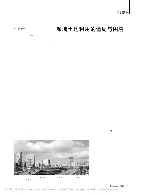
特别策划7February 2013深圳土地利用的僵局与困境文 / 贺雪峰一深圳是特区,特区的特点是摸着石头过河,允许试,边试边总结经验。
在深圳特区优惠政策推动下,国内外资金有到深圳发展的极大动力,资金的涌入带动了深圳全域的工业化,国家(深圳市区政府)、村庄集体和农民,三个轮子一起转,高端低档一起上,结果就是深圳经济增长速度极快,在很短的时间内其经济总量即达到不可思议的规模。
正是三个轮子一起转,在深圳经济高速发展的同时,其土地资源很快耗尽,土地资源的利用程度远超警戒线,现在基本上已无地可用。
而由此形成的土地利用无规划,和土地权属不规范,以及因为土地利用而产生的各种既得利益和利益刚性,又使得整个深圳市陷入严重的城市无序之中,深圳要实现产业升级,实现城市发展的有序,实现合理的规划目标,面临着调整土地权属的极大障碍和困难。
如何改变目前形成的几乎是混乱无序的土地使用状况,成为深圳能否实现经济转型和城市发展的一个未曾预料到的关键因素。
二深圳形成目前土地乱象的时间起点是在修订的《土地管理法》出台前。
按《土地管理法》(修订)(1998年)第四十三条规定,“任何单位和个人进行建设,需要使用土地的,必须依法申请使用国有土地”,深圳以及整个珠三角的发展,都以招商引资,“三来一补”为发展起点,基本上是政府和村社集体一起上,调动了各方面招商引资积极性,而农民通过在自己宅基地上建房出租,来获得土地非农使用的租金收益。
按《土地管理法》,深圳土地实践中,违反政策之处甚多,第一,宅基地只能自用,不能流转,宅基地上建房也不能用于经营性目的。
深圳几乎所有农民都建房出租出售;第二,农地需经征收变为国有建设用地,才能用于经营性用途,但深圳只有少部分农村集体建设用地经过征收变为国有然后进入城市建设用地市场,而多数是不经征收即自建工业园区,自行用于经营性用途,甚至自行流转使用权;第三,耕地若用于建设性用途,必须经由土地部门的严格审批,但深圳目前在仍为农业用途的土地上已经建满厂房和住房,根本就没有农地尤其是根本就没有耕地了;第四,国家每年下达到地方的新增建设用地计划是不能突破的,但深圳市村社集体自行将集体土地用作建设用途,根本就没有纳入到国家计划范围内。
城市土地利用变化分析与机理探究随着城市化进程的加速,城市土地利用也在发生着不断的变化。
本文将以深圳市为例,分析城市土地利用变化的规律,并探究其机理。
土地利用类型变化情况从1980年到2000年,深圳市的土地利用类型经历了明显的变化。
根据统计数据,农业用地比例从1980年的89.2%减少到了2000年的17.6%;而城镇用地比例则从1980年的不到1%增加到了2000年的47.6%;同时,还有大量的土地从林地、草地等自然资源用地转化为了建设用地。
这些变化的原因,主要是由于深圳市城市化的加速,需要大量的土地建设住宅、商业和工业用地,从而使得城镇用地比例大幅增加;同时,工业化、城镇化也使得农业用地逐渐减少,进一步加快了土地利用结构的调整。
城市土地利用变化的机理城市土地利用的变化涉及多方面的因素,主要可以从如下三个角度进行解读:1.经济发展和城市化进程推动了城市土地利用变化城市经济的发展,需要更多的土地来建设住宅、商业和工业用地。
同时,城市化进程在加速,减少了农业用地的比例。
这些因素推动了城市土地利用的变化。
2.土地政策和规划引导了城市土地利用变化政府的土地政策和规划文件,对城市土地的利用和分配起到了重要的引导作用。
比如,政府可以出台土地利用政策,鼓励农村闲置土地向城市倾斜;规划文件也可以制定城市用地结构调整目标,引导土地向住宅、商业、工业和公共设施等用地倾斜。
3.城市居民消费需求和环境保护要求影响了城市土地利用城市居民的消费需求,比如对住房、公园、购物中心等场所的需求,也会影响城市土地的利用。
同时,环境保护也成为城市土地利用变化中的一个重要因素,政府会对环保区域保护性用地进行限制,而居民也会要求绿地和公园的增加。
结语城市土地利用的变化是城市化进程的必然产物,也是经济社会发展的需要。
通过对深圳市的土地利用变化情况进行分析,可以看出城市土地利用变化主要受到经济发展和城市化进程的影响,同时也受到政府政策和居民消费、环保要求的影响。
深圳市土地利用变化驱动力系统分析王兆礼;陈晓宏;曾乐春;魏清泉【期刊名称】《中国人口·资源与环境》【年(卷),期】2006(016)006【摘要】以深圳市土地利用变化的驱动力系统为例,用灰色关联方法确定影响土地利用变化的驱动因子并判别其最大驱动力,结果表明:深圳城市建设用地面积变化与外资利用额的关联系数最大,达到0.8491,其次为基础建设投资额、第三产业产值、工业总产值及总人口数量;耕地、林地、荒地、水域面积变化则与城市化率的关联系数最大.以1991-1999年间的建设用地面积作为灰色系统特征数据序列,选取与其关联系数最大的五个驱动因子序列数据作为相关因素数据系列,建立GM(1,6)模型,结果表明:该模型的计算值和实际值的相对误差最大为11.11%,最小为-0.25%,平均相对误差也只有3.41%;检验结果表明,2000-2004年的模拟值与检验值的平均相对误差仅为3.74%,模拟精度较高,因而可以利用该模型预测深圳市建设用地的增长规模.【总页数】5页(P124-128)【作者】王兆礼;陈晓宏;曾乐春;魏清泉【作者单位】中山大学水资源与环境研究中心,广东,广州,510275;中山大学水资源与环境研究中心,广东,广州,510275;广东省征地服务中心,广东,广州,510081;中山大学城市与区域研究中心,广东,广州,510275【正文语种】中文【中图分类】F2【相关文献】1.2005—2015年四川省土地利用变化及驱动力分析 [J], 罗鸿;杨存建2.1980-2015年黄河流域土地利用变化特征与驱动力 [J], 廖慧;舒章康;金君良;杨传国;王国庆3.广西桂林市土地利用变化及其驱动力分析 [J], 魏锋;童新华;韦燕飞4.永吉县2000~2020年土地利用变化及其驱动力分析 [J], 孙晶艳5.基于GIS的达州市土地利用变化及其驱动力分析 [J], 胡文婷;魏新祎因版权原因,仅展示原文概要,查看原文内容请购买。
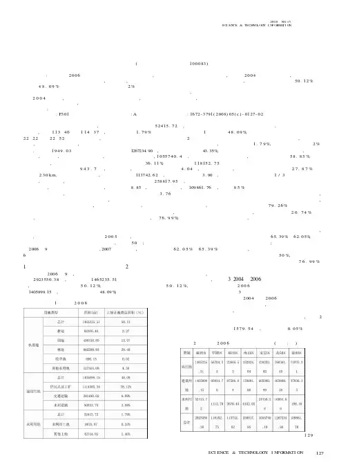
2006年一季度深圳市土地分析报告一、土地供应情况分析(一)计划供应总量分析2006年深圳市国有土地使用权出让计划总量为12.29平方公里,比上年的计划总量12.69平方公里约减少了3.15%,而较2002年的计划总量17平方公里减少了4.71平方公里,降低了27.7%。
据统计,近四年间深圳市年均出让土地面积约为13平方公里。
2006年深圳市计划供应的土地总量基本与上年计划总量持平,计划的编制遵循严控土地供应总量,优化土地供应结构,提高土地资源市场化配置比例的原则,以不断提高深圳市土地资源的集约利用水平。
(二)计划供应结构分析从区位看,2006年深圳市土地供应仍主要集中在宝安、龙岗两区、特区外两区计划出让用地面积合计为1080.6万平方米,占全市计划出让土地总面积的87.9%;特区内计划出让用地面积共为108.3万平方米,占全市计划供应总量的8.8%。
此外,计划有40万平方米政策性住房用地供应,以保证近几年内低收入人群的住房需求,约占供应总量的3.3%。
从用途来看,2006年全市计划供应住宅用地144.1万平方米,占供应总量的11.7%,其中104.1万平方米为商品住宅用地,40万平方米为政策性住房用地;工业用地704.6万平方米,占供应总量的57.3%;仓储用地55万平方米,占供应总量的4.5%;商服用地30.2万平方米,占供应总量的2.5%;公共建筑用地96.1万平方米,占供应总量的7.8%;公用服务设施用地198.9万平方米,占供应总量的16.2%;特殊用地计划供应量为零。
对比2006年和2005年土地供应计划,2006年工业用地供应规模有较大幅度的下降,减少了25.8%。
近年来,工业用地一直是深圳土地供应的重点,供应比例也一直保持增长的势头,但随着存量土地资源的逐渐消耗,土地资源已经成为制约深圳社会经济持续健康发展的四大瓶颈因素之一,因此,工业用地的集约利用成为新形势下的战略选择。
这也与深圳调整产业结构,加快以技术资金密集型产业为主的工业结构升级,走新兴工业化道路的工业发展战略相适应。
深圳市城市更新问题总结及典型案例分析报告2021-11-16目录一、深圳城市更新问题梳理错误!未定义书签.〔一〕价值导向:忽略了对城市更新本质的思考,缺乏人文关心..错误!未定义书签.1、当前城市更新处于“见物不见人〞的状态错误!未定义书签.2、以大拆大建为主导的城市更新建设对历史记忆与文化遗传传承重视不够错误!未定义书签.3、市场与政府的关系定位不清楚,缺乏有效协同错误!未定义书签.〔二〕治理机制:职能配置不清,政策设计滞后错误!未定义书签.1、职能配置:纵向责任定位不清,横向权责边界模糊....... 错误!未定义书签.2、制度设计:制度零碎、缺失、缺乏有效协同错误!未定义书签.3、操作流程:现行零散、复杂的操作流程给城市更新工程实施增添压力错误!未定义书签.二、深圳城市更新典型模式及评价错误!未定义书签.〔一〕特区内城中村改造模式一撤除重建类错误!未定义书签.1、蔡屋围旧改模式错误!未定义书签.2、岗厦旧改模式错误!未定义书签.3、渔农村改造模式错误!未定义书签.4、大冲旧改模式错误!未定义书签.5、鹿丹村旧改模式错误!未定义书签.6、模式特征总结错误!未定义书签.〔二〕原集体经济组自改模式一一传统旧改类错误!未定义书签.〔三〕工改商更新改造模式一一功能改变类错误!未定义书签.1、集体合法用地的旧改:西乡劳动村错误!未定义书签.2、制度边界上的预期:未经批准改变功能错误!未定义书签.〔四〕旧工业区升级改造模式一一综合整治类错误!未定义书签.1、沙浦国际艺展中央模式错误!未定义书签.2、笋岗艺展中央综合整治错误!未定义书签.3、华侨城创意文化园三期工程错误!未定义书签.4、葵涌鸿华印染厂综合整治工程错误!未定义书签.5、模式特征总结错误!未定义书签.、深圳城市更新问题梳理〔一〕价值导向:忽略了对城市更新本质的思考,缺乏人文关怀1、当前城市更新处于“见物不见人〞的状态城市更新是为了实现城市整体功能的优化, 根底设施的完善,以最终实现城市的可持续开展及新型城镇化建设.而当前所谓“绅士化运动〞的城市更新建设一直是物的视角,缺乏人的考虑,忽略了城市的生命主体一一人,尤其是城市中的低收入人群.在城市更新的过程中,城市的生活质量是提升了,但与此也带来了不断增高的生活本钱,导致城市中不可缺少的低收入外来人群如农民工等无法在城市立足,而他们是城市组成中不可或缺的一个重要局部.2、以大拆大建为主导的城市更新建设对历史记忆与文化遗传传承重视不够城市的历史文化是城市在开展过程中经过大浪淘沙历史沉淀的成果,承载了城市开展的命脉,是城市的灵魂,是城市进步和开展的积竭力量.而在现行城市更新过程中,虽然更新方式一般分为综合整治、功能改变和撤除重建三种,但现在一般提及城市更新,均是以撤除重建为主,大拆大建的城市更新建设一方面破坏了历史的痕迹,磨灭的城市的历史记忆,另一方面造成城市仅存的少有历史建筑、风貌区等城市文化遗产的破坏,致使城市的人文精神逐渐散失.如何在保护好历史文化遗传的同时更好的进行城市更新建设,完善城市功能有待进一步探究.3、市场与政府的关系定位不清楚,缺乏有效协同深圳市城市更新遵循“政府主导,市场运作〞的原那么,这一原那么提升了资源配置的效率,但与此同时也导致市场和政府之间的关系定位不清楚, 市场与政府两者的力量和关系失衡,引发“市场过度、政府空缺〞等一系列问题:〔1〕“市场过度〞,当前城市更新主要由市场主导,方案由市场申报,规划由市场行使等一方面导致城市更新工程普遍存在“挑肥拣瘦〞的现象,开发商往往倾向于改造易于实施、容积率较低且具有较大商业价值的区域,一些亟待通过更新完善城市功能的老旧片区由于经济收益有限而难以推动,政府意愿和市场操作发生错位;另一方面开发商往往更注重短期经济效益, 根本上偏向于商业、住宅开发,对基础设施和公益事业建设缺乏,对社会、环境、文化等方面的整体提升关注度不够, 导致城市更新规那么失序,公共利益受损、社会利益分配失衡.〔2〕“政府缺位〞,政府作为城市更新的主体,在更新过程中不能发挥其应有的作用,导致规划方案在其引导作用中失灵,导致城市更新工程偏离其本质目的, 成为市场、原权利主体获取利益的工具,更新过程混乱.缺乏在城市更新过程中起到统筹调节的作用, 不能及时解决和有效应对城市更新过程中遇到的问题, 缺乏对市场主导的开发模式的引导和限制,尤其是在开发商与小业主博弈不能达成一致时公权力救济空白.〔二〕治理机制:职能配置不清,政策设计滞后1、职能配置:纵向责任定位不清,横向权责边界模糊〔1〕纵向职能配置:市、区两级政府在城市更新过程中责任定位不清楚、责任划分不明确城市更新是城市存量开展阶段的新生事物, 运作流程较长,一个城市更新项目从前期意愿征集、中报、规划方案审批到工程实施完成,大概需要3-8年的时问.市区政府在不同的环节均具有不同的申报和审批职能,当前的职能配置存在很大的问题:〔1〕市区政府定位不明:当前“强区放权〞的要求导致现行城市更新职能配置混乱,市、区两级政府不能明确自身在城市更新过程中的定位,导致当前城市更新工程“个案主义〞的审批现象严重, 缺乏“准那么主义〞的指导.〔2〕市区政府责任不清:城市更新涉及街道办、区旧改办、区治理局、区政府、市更新局、规土委等市区多个不同的部门,市区政府之间的权责缺乏精确的划分, 也缺乏相关工作机制的约束.现行机制中,街道办管的太多,又管的不好,且程序不明确,导致当事人不胜其扰.应明确市区各治理部门的责任,一方面限制、明确街道办的责任在于集体资产处置治理,另一方面明确区更新局方案的作用及管理局规划的作用,同时增强市更新局、规土委的统筹把控作用.〔2〕横向职能配置:部门间权责边界交叉,业务流程不明,尺度把握不清城市更新涉及市区各部门,〔1〕各部门间的权能缺乏明确的统一与治理, 职责边界模糊,导致审批过程混乱,部门之间推卸责任现象严重;〔2〕无论是市还是区内各部门无法明确自己在城市更新中的责任, 对城市更新的申报要求缺乏系统的学习和熟悉,各区相同的部门,一个区不同的部门对申报的相关要求不统2、制度设计:制度零碎、缺失、缺乏有效协同〔1〕城市更新利益配置与其他存量土地二次开发方式缺乏有效协同,阻碍历史违建的处理、土地整备等的实施城市更新、土地整备及原农村集体土地入市作为城市存量土地二次开发的不同方式,由于不同方式治理部门不同,三种方式之间缺乏统筹的思考和平衡, 导致不同方式经济利益差异较大,缺乏利益协调机制及利益天花板的限制. 利益机制的不协调导致相关主体尤其是开发商和原权利主体在选择利益较高的方式,严重阻碍了历史违建的处理、土地整备的进程.〔2〕利益相关者诉求不兼容城市更新涉及多个利益主体,包括政府、原集体、原村民、小业主以及开发商,不同利益主体的利益诉求不同,他们之间存在多变的相互联系和作用.〔1〕政府参与城市更新的主要动力在于追求城市开展宏观层面的公共利益,在于改善城市环境、提升人居环境、优化产业空间布局结构、推动公共根底设施建设.〔2〕市场主体参与城市更新的主要动力在于获得一定面积可开发的土地资源,通过开发前后地产价格的变动来获得巨额收益.〔3〕对于原权利主体来讲,城市更新后安置条件获得改善,同时可以获得货币和产权补偿,涉及原集体经济组织的城市更新,更是可以从中得到合法确实认和高额的经济利益.在政府、市场和原权利主体利益诉求不同的同时,彼此间的利益也存在的此消彼长的不兼容.一方面, 政府为了吸引更多的市场主体,不断的让利于市场,另一方面,市场为了获得更多的更新意愿,不断让利于原权利主体.利益诉求的不兼容导致更新主体间矛盾突出,原权利主反悔现象严重,更新工程停滞显现严重.〔3〕不同城市更新方式利益空间差异悬殊,产业开展空间难以保证1〕不同城市更新方式利益空间差异悬殊,缺乏有效协同,导致更新方式的选择难以限制,造成“一边倒〞的更新结构.城市更新涉及类型较多,如工改工、工改保、工改商住、商住改商住、综合体改造等,不同改造类型的地价政策和门槛存在很大的区别,例如工改工工程利润较小,开发商缺少对其进行更新的动力, 即使是选择工改工,也是挂羊头卖狗肉,用办公楼和住宅变相代替厂房,据调查, 深圳市宝安区已建成的“工改工〞工程中, 除一例是改造为生产性用房外,其余全被变相更新为带有“商住〞性质的工程.这种“挂羊头卖狗肉〞式的工改工, 直接推高了深圳创新型研发用房的供给量, 并已产生了“供大于求〞的潜在闲置问题,同时萎缩的生产性用房面积极大的阻碍了深圳市制造业的开展.而与之相反,由于存在巨额的利润,工改商住等更新方式驱动力那么较强, 而居改居工程因为利益分配,意愿难搜集等问题导致多处工程启动后停滞.2) “一边倒〞的更新结构严重制约工业的开展,导致产业空间难以得到有效保证.以深圳市宝安区为例,自2021年以来,共有108各工程被列入城市更新单元方案,其中仅有30 个“工业改工业〞的工程,而“工改居〞、“工改商〞及“工改商住〞的比例那么高达50%在利益诱因下产生的“一边倒〞更新结构已经严重影响了企业的生存空间,不仅直接减少了工业用地的保有量, 更让局部优质企业由于承租厂房的更新改造及改造后翻倍的租金而被迫迁离深圳.(4)零敲碎打,难以提供集中连片的产业空间由于政府缺乏片区统筹的概念,缺乏有力的规划管控,城市更新单元破碎现象严重.破碎的空间,既不利于现代化产业配套设施的落地, 也难以为战略性新兴产业、高新技术产业等重大产业工程的拓展提供集中连片的空间保证, 从而极大的制约了产业的开展.(5)城市更新政策缺乏类型化的流程设计,整体统筹,政策零散多变1)城市更新类型较多,有市场主导的城市更新、政府主导的城市更新、权利主体自行改造的城市更新、市场主体实施改造的城市更新等,现行政策将不同类型的城市更新混淆,缺乏类型化的政策设计,统一的规划统筹,大都以打补丁的形式出现,导致政策零散化、破碎化,同时“打补丁式〞的政策设计导致城市更新政策体系尚不完善,很多地方存在空白,给政府、开发商、原权利人等在城市更新实施过程中带来很大的不便.2)城市更新政策一直处于不断变化及更新的状态,在不同政策中更新指标如合法用地比例、奉献率等都在不断的发生改变, 加剧了政府、开发商和原权利人对政策理解的难度, 使得政府经办人、开发商等不能理清城市更新的详细流程和细节,严重滞后城市更新实施,效率及周期.(6)城市更新政策缺乏与其他相关政策的协同更新随着市内其他相关政策的出台和更新,各区相关部门也需对城市更新政策进行配套.如1)对于合法外用地,随着三规(关于处理违法用地的规定和关于处理违法建筑的规定)的更新,考虑到每个区有不同的历史遗留问题和背景, 各区城市更新相关部门也需要在城市更新政策中对相关要求进行更新补充.2)对于合法用地,城市更新必然涉及土地资产的相关处置, 考虑到深圳市土地的二元化治理,在关内进一步健全和完善国有资产处置规那么, 关外进一步健全和完善集体资产处置的相关政策的根底上,城市更新政策需要与此进行协同更新.(7)用地处置政策较为繁杂、处置门槛不确定性强,历史遗留(违法私房)问题的处理有待增强当前用地处置相关政策和环节太过繁琐,亟需简单化、体系化:1〕是否可以考虑与一般用地处置过程相衔接, 将用地处置过程简化,同时,考虑到用地处置必然涉及地价的测算,可以考虑将用地处置政策与地价政策联动, 计算城市更新过程中的总账也是简化地价政策的一种方式.2〕在深圳原特区外的区域,城市二元化特征明显,存在大量在1992年和2004年深圳土地“统征〞“统转〞过程中产生的征转手续不完善的历史遗留用地.这些土地从法律上来说已经国有化,但是由于征收和补偿手续不完整,故存在权利“瑕疵〞.根据一般的法律原那么,只有权属清楚的合法用地才能进行交易进而纳入城市更新单元.然而在原特区外的更新单元划定中,几乎无法到达这一要求,故不得不降低更新门槛.2021 年?暂行规定?制度突破时,允许30%勺合法外用地纳入更新范围,2021年?暂行规定?修订稿将这一比例降低为40%且对旧工业区综合整治也放开了门槛, 允许50%勺合法外工业用地纳入更新范围,也就是说原集体经济组织自己修建、外卖、或是合作的旧工业厂房都可以纳入升级改造的范围.3〕对于历史遗留问题〔违法私房〕的处理,要增强其可操作性,在尊重历史事实的前提下,区分合法内与合法外以及不同时段等不同情形,形成系统化的政策体系,防止简单化、“一刀切〞.否那么可能会导致“逆向选择〞,诱发新的更多的违法建筑.〔8〕非农建设用地指标的交易缺乏标准城市更新政策规定非农建设用地是合法用地的主要来源之一,但非农建设用地通常使用指标进行治理,局部指标已落地,局部指标未落地;局部指标已建成, 局部指标未建成,现象纷繁复杂.非农建设用地纳入更新的,更新主体仅需要交纳10%勺基准地价,因此基于开发商的逐利性,他们倾向于购置其他社区的非农建设用地指标覆盖更新单元范围,引起非农建设用地指标的交易和买卖.但是, 1〕非农建设用地指标能否跨社区流转、跨街道、跨行政区流转仍属于政策空白, 在全市的做法也不尽统一.严格标准非农建设用地治理,明确指标与更新工程、与社区集体分红之间的关系是亟需解决的问题.2〕非农建设用地指标的跨区交易会导致更新单元内开发量的集聚, 带来人口的增加,但是与此同时,公共配套设施却没有相应的增加,长此以往,会导致从单个工程的角度出发,公共施设满足规划的要求,但是大的片区角度,公共设施存在严重的缺乏.〔9〕规划权实际由开发商行使,政府对城市更新治理缺乏统筹手段与依据当前城市更新政策体制、治理机制尚不完善.1〕作为公共权力的规划权,由开发商行使值得商榷.现行城市更新单元规划根本都由开发商制订, 而开发商是以自己的利益为优先,缺乏整体的熟悉和把握,并且与规划权作为政府的公共权力相背离,因此规划是否应由市场主导需要重新定位和考虑;2〕全市的更新专项规划太粗,各区的更新专项规划缺位,导致规划审批缺乏合理的依据,土地功能、容积率的规定缺乏刚性规定,弹性太大,给开发商单点突破留下了空隙, 导致政府在城市更新实施过程中缺乏空间上格局的把握和整体上数量的把握.(10)城市更新方案规划缺乏联动规划方案是政府限制城市更新质量、进度的根底,是其统筹片区开展的关键. 但现行以市场为主导的城市更新中, 规划由市场行驶,方案由市场中报,导致规划、方案缺乏必要的联动,导致1)规划失去其片区统筹管控的作用,成为市场追逐利益的工具;方案定位不清,仅仅为工程的数量统计,缺乏对更新需求的把控.2)城市更新失去片区的统筹定位导致公共根底设施严重缺乏,公共利益不断受到侵犯.(11)城市更新方案如何定位,如何起到真正的作用缺乏深入思考当前城市更新单元工程一般由市场提出, 由政府统一纳入方案,而方案的理念比拟滞后,仅仅起到了对工程申报的汇总作用, 不适应市场主导的城市更新运作模式,需要对城市更新方案的定位、编制主体等内容进行重新思考.(12)更新单元规划管控作用不显著,公共设施与开放空间保证机制不顺畅城市更新单元规划是对整个工程的管控, 决定了工程实施过程中开发商的利益,社会公共根底设施保证等,而当前规划由市场编制,失去其管控作用,导致城市更新工程成为开发商逐利的工具和手段, 公共设施和开放空间无法得到有效保证和落实.是否可以考虑内部允许容积率的转移, 抑或其他形式的鼓励奖励机制(奖励方式未必是容积率),以鼓励奉献更多的公共设施与开放空间用地,以满足公共利益的需要.(13)交易价格标准、拆迁补偿机制缺失,政府公权力不介入,导致钉子户现象严重追求高额的经济利益是更新主体选择城市更新的最大原因,而利益天花板的缺失导致更新主体趋利现象越发严重.1)现行城市更新由市场主导,但由于缺乏标准的交易价格标准,致使开发商想通过城市更新获得尽可能多的经济利益, 不断的利用政策空隙向政府提出土地功能改变、开发容积率增高等各种要求,政府为了城市更新工程的进行不断让利,不利于城市更新长远、多元化目标的实现. 2)对于原权利主体而言,由于缺乏合理的拆迁补偿机制,使其心理缺乏利益的权衡,想通过城市更新所获得的利益处于无底洞的状态,导致钉子户现象越来越严重,更新意愿越发难以收集,更新进程难以为继.3)开发商与原权利人的博弈是城市更新不可防止的现象,很多城市更新工程由于此问题导致工程停滞, 而现行制度规定在开发商与小业主之间无法达成协议的情况下,第三方公权力机构,包括政府、法院等均不得强制介入,使得这一情况无法在现行法律框架下得到妥善处理,导致现实中出现了异化的矛盾处理方式.(14)城市更新融资渠道狭窄现行城市更新主要是以市场主导的城市更新为主, 一般都是开发商通过银行贷款的方式进行融资,在城市更新开展过程中,有必要增强政府主导的城市更新方式,引入地方债券、土地金融产品等多种形式的融资渠道.(15)地价政策体系及标准较为复杂城市更新中涉及的地类复杂,不同类型土地的地价计算标准均存在很大的不同,同一类型涉及的计算标准根据不同的情形也不一样, 可以考虑在与用地处置政策进行联动的根底上进行简化. 此外,现行的评估地价标准主观性较强, 不同的评估师所使用的标准不一,致使所计算的地价差异很大.(16)城市更新社会风险评估机制缺失当前的城市更新缺少社会风险评估机制,导致很多工程已经进入实施阶段, 但却由于种种原因停滞不前,而绝大局部都是由于意愿难以达成一致, 建议考虑在方案申报的过程中增加社会风险评估或增加利益相关者听证环节,降低更新项目实施风险.(17)城市更新政策宣传教育力度不够,对内行政人员和技术人员的培训不到位,对外缺乏必要的公众教育和政策宣传手段城市更新申报审批流程极其复杂,涉及到的部门和经办人较多,但现行体制宣传角度力度有待增强,1)对内相关行政人员和技术人员培训不到位,导致不同岗位的经办人无法正确理解城市更新政策, 不能明确自己所在岗位的责任,无法准确把握城市更新的审批细节,严重影响了工程审批的效率,甚至会影响工程的承办;2)公众的参与是城市更新工程实施必不可少的一局部,考虑到不同层次城市居民信息获取手段不一,很多居民尤其是城市更新工程涉及其切身利益的居民并不能真正的参与到城市更新过程中, 是否可以考虑增加公众参与的方式以及力度.3、操作流程:现行零散、复杂的操作流程给城市更新工程实施增添压力(1)审批环节流程复杂、周期长、不标准,特殊审批环节缺乏与现行政策衔接的路径城市更新工程的审批包括较多环节, 含前期意愿征集、方案审批、建筑物核查和确权、更新单元规划编制、规划审批、拆迁谈判、实施主体确认、房屋产权注销以及后续的用地手续办理.一方面前期意愿征集和拆迁谈判需要花费较长的时间,另一方面更新工程规划、方案的审批,权属核查等审批方面流程复杂.一般而言,一个更新工程从审批到建成一般需要3-8年的时间,亟需简化流程、规范操作、提升效率.为提升政府行政效率,加快机构体制改革,城市更新应该更加减政放权、增强统筹,建立权责清楚、分工合作的大城市更新治理体制;进一步优化市区职能分工,理清市区政府和各职能部门应该做的事情.如何再造城市更新的治理流程链条,关键是把握城市更新的根本规律,厘清政府到底应该管什么,在此根底上,抓住核心环节,把次要环节裁减或者合并.同时,城市更新过程涉及很多特殊情形和环节如历史用地处置, 农村集体土地入市等,各区在进行城市更新过程中也处于不断摸索解决的状态,现行政策中缺乏对此类情形的考虑.(2)功能改变与综合整治的审批流程零碎或者缺失当前以撤除重建居多的城市更新方式致使功能改变与综合整治的审批流程零碎且缺失.1)其零碎表达在现行?深圳市城市更新方法?、?深圳市城市更新方法实施细那么?等相关政策文件中均提到功能改变和综合整治城市更新的相关流程,但缺乏像撤除重建类城市更新方式那样详细的说明,导致功能改变、综合整治类城市更新审批流程零碎.2)缺失主要表达在对功能改变、综合整治类城市更新的审批流程缺乏系统的设计,许多审批环节缺乏说明,导致现行功能改变、综合整治类城市更新审批流程混乱,多以地方实践摸索为主.(3)更新单元规划审批应当在区分不同情形根底上尽可能简化、下放,核心是审查公共利益是否足额、有效保证.明确哪些情形属于未改变法定图那么强制性内容,对于未改变法定图那么强制性内容的情形,简化审批程序,缩短审批时间.(4)实施主体确实认过程过于混乱.1)在当前实施主体确认过程中,奉行的是丛林法那么,一般对于同一城市更新工程,多家开发商进行竞争争夺,原权利主体通过比拟开发商的补偿标准进行选择,加剧了城市更新恶性竞争,无形中推高了拆赔比,导致城市更新越发难以进行,政府可否以通过实施主体拍卖或招标等方式介入实施主体确认机制.2)实施主体确实认过程花费时间较多, 对于不同的城市更新类型,尤其是申报主体和实施主体属于同一主体的城市更新工程,是否可以考虑对实施主体确实认取消或者与其他环节合并,如对于申报主体和实施主体为同一主体的城市更新,可在确定申报主体时一并确认实施主体.(5)房地产证注销环节存在的必要性需要重新定位与思考.从保护物权和遵守契约,尤其是物权法在住宅的建设用地使用权自动续期的背景下,是否一定需要进行房地产证注销值得重新定位和思考.例如对于在规定年限内的住宅,如果权利主体自行改造,是否可以选择不注销房地产证,而仅仅是对其剩余年限进行改造(6)欠缺工程实施全过程监管机制.。
14卷6期2005年12月自 然 灾 害 学 报JOURNAL OF NAT URAL D I S ASTERS Vol .14,No .6Dec .,2005收稿日期:2005-11-20; 修订日期:2005-12-06 基金项目:国家自然科学基金资助重点项目(40535024) 作者简介:郑(1982-),男,山西晋城人,硕士研究生,主要从事土地利用变化及水文模型研究.文章编号:100424574(2005)0620077206土地利用变化对地表径流深度影响的模拟研究———以深圳地区为例郑1,2,袁艺1,3,冯文利4,史培军1,2(1.北京师范大学环境演变与自然灾害教育部重点实验室,北京100875; 2.北京师范大学资源学院灾害与公共安全研究所,北京100875; 3.民政部国家减灾中心,北京100053; 4.中国土地勘测规划院,北京100029)摘要:结合基于遥感数据获得的土地利用结果与SCS 水文模型,在GI S 环境下模拟了深圳地区城市化不同阶段土地利用变化对地表径流深度的影响。
结果表明:在深圳城市化的不同阶段,由土地利用变化所引起的地表径流深度的变化亦有所不同。
在假设24h 降水200mm 的情景下,1980至1988年间,深圳地区城市化使其扩张地区的地表径流深度减少了0.33mm,而在1988至1994年和1994至2000年这两个阶段,城市化则使其扩张地区的地表径流深度分别增加了6.96mm 和0.69mm 。
关键词:土地利用变化;城市化;地表径流深度;SCS 模型;深圳中图分类号:X43 文献标识码:AM odel research on i m pact of l and 2use change on surfacerunoff depth:a ca se study on Shenzhen Reg i onZ HE NG J ing 1,2,Y UAN Yi 1,3,FENG W en 2li 4,SH I Pei 2Jun 1,2(1.Key Laborat ory of Envir onmental Change and Natural D isaster,M inistry of Educati on of China,Beijing 100875,China; 2.I nstitute ofD isaster and Public Security,College of Res ources Science and Technol ogy,Beijing Nor mal University,Beijing 100875,China;3.Nati onal D isaster Reducti on Center of China,M inistry of Civil Affairs of China,Beijing 100053,China;4.China Land Surveying and Planning I nstitute,Beijing 100029,China )Abstract:By integrating re mote sensing data and SCS hydr ol ogical model under the GI S envir on ment,the i m pact of land 2use change on surface runoff in Shenzhen regi on is studied .The result shows high variety and comp lexity of the i m pact .Fr o m 1980t o 1988,land 2use changes due t o urbanizati on led t o an average decrease of 0.33mm in surface runoff under the assu mp ti on of a 200mm daily p reci p itati on event in the ne w urban gr owth regi on .W hile fr om 1988t o 1994and fr om 1994t o 2000,the consequence of land 2use change was increase of 6.96mm and 0.69mm ,res pectively .Key words:land 2use change;urbanizati on;SCS model;surface runoff dep th;Shenzhen 土地利用变化是人类影响和改造自然界的最显著标志,亦是区域乃至全球变化的主要驱动因素之一,其原因在于土地利用变化对于自然环境系统,包括水文过程、生态过程等都有着深刻且显著的影响。
深圳市土地整备问题分析摘要:土地整备是土地资源二次开发的重要手段和方法,深圳市土地整备有其历史和现实意义。
首先对深圳市土地利用现状、面临的形势进行了阐述,然后对深圳市近几年土地整备情况进行了概括总结,最后对深圳市目前土地整备存在的问题进行了分析。
关键词:土地整备,深圳,土地利用土地整备作为深圳土地资源紧约束下发展的创新工具,与城市更新并列为城市土地二次开发的“两驾马车”。
“十三五”期间,深圳将迎来新一轮的转型发展机遇期,同时也是土地资源拓展受限情况下推进改革发展的关键阶段。
如何以土地为抓手,通过灵活运用现有土地政策实现土地资源的充分利用、土地资产最大化、土地资本的快速高效流转等目标,是土地制度改革必须关注的问题。
土地整备在深圳新一轮城市发展建设过程中,源于其政府主导的优势,在促进产业转型升级、保障公共基础设施及重大项目建设方面无疑将发挥供给侧改革作用。
尽管土地整备定位为政府主导下的二次开发工具,实施面更广,包括了房屋征收、土地收回、填海(填江)、土地收购等多种方式,但放眼全市范围,实践操作中仍以房屋征收为主,土地整备中的其他方式要么受实施条件限制无法推广、要么推进难度较大,原权益人不愿配合。
由此导致的客观结果是,以土地整备的名义实施征地拆迁,本质上与过去未开展土地整备并无实质性改变。
这显然与深圳土地整备的历史和现实定位是错位的。
1 深圳市土地利用的现状和面临的形势1.1 深圳市土地利用形势严峻,空间拓展压力大30年前,深圳以土地市场化改革为突破口,以土地资源为载体,搭建了市场经济发展的平台;以土地资本为依托,解决了城市建设的资金缺口,率先在全国实现了土地资源与资本的统一,创造了中国乃至世界城市发展和建设史的典范。
30年后,同样因为土地问题,深圳面临传统发展模式下城市经济发展和空间拓展的瓶颈。
一方面,深圳新增可利用土地潜力十分有限,城市面貌的改善和提升、产业结构优化升级、基础设施建设及重大项目落地等问题很难像过去那样通过新增建设用地予以解决。