2007年中国大陆地震灾害损失述评_米宏亮
- 格式:pdf
- 大小:266.34 KB
- 文档页数:5

蔡宗文、危福泉、方瑞峰等,2007,基于居民地分布的震害快速评估方法,中国地震,23(4),410~415。
・研究短文・基于居民地分布的震害快速评估方法蔡宗文1) 危福泉2) 方瑞峰1) 郑韶鹏1) 陈琳2) 付萍1)1)厦门地震勘测研究中心,福建省厦门市集美区岑东路189号 3610212)福建省地震局,福州 350007关键词: 震害评估 居民地分布 人口统计资料 易损性矩阵[文章编号]100124683(2007)0420410206 [中图分类号]P315 [文献标识码]A[收稿日期]2006211212;[修定日期]2007212212。
[项目类别]福建省自然科学基金(D0410024)、福建省重点科技攻关项目(2003Y 039)资助。
[作者简介]蔡宗文,男,1970年出生,高级工程师,1992年毕业于北京大学地震地质学专业,理学学士,主要从事工程地震研究及信息技术开发工作。
E 2mail :caisin fo @ 。
0 引言地震灾害总是伴随着巨大的生命和财产损失。
随着城市化的加速发展,人口不断地由农村向城镇地区集中,使地震灾害造成的损失有增大的趋势(陈 等,2001、1997)。
地震发生后,快速地做出地震灾害损失评估,对地震应急救援具有重要指导意义。
如何快速有效地进行地震灾害损失评估,国内外地震专家做了深入的讨论,开展了大量的城市震害预测和震灾快速评估研究,建立了一系列基于城市大规模单体及群体调查的地震应急灾害损失评估模型。
但是,基于城市的震害研究投入大,系统数据不易更新,难以在全国范围内大规模开展。
破坏性地震波及半径通常要达到100多公里或更大的范围,以城市为单元的灾情快速评估有其不可避免的局限性。
本文主要作者自2003年开始在传统的震害预测模型的基础上,提出了基于人口统计资料进行震害预测的模型及方法,应用实践证明,基于人口数据的震害评估方法,具有快速(全省区域,1~2分钟)、可行及较为可靠的特点(蔡宗文等,2006)。
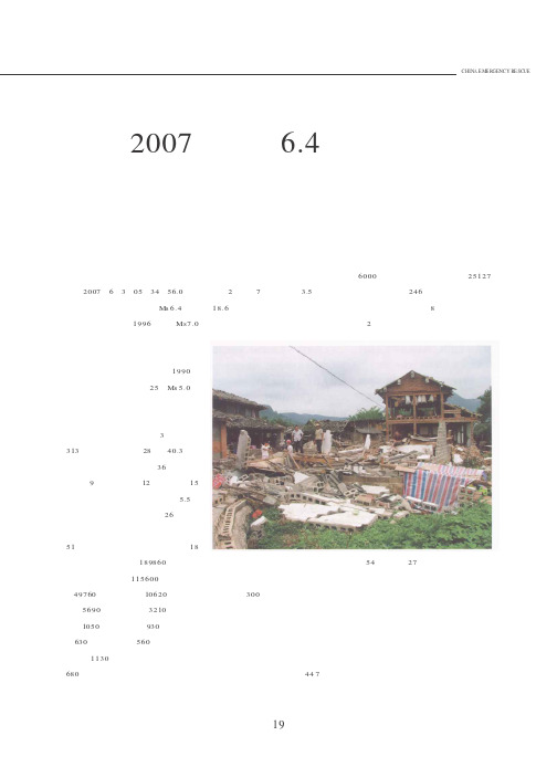
前言2007年6月3日05时34分56.0秒,云南省普洱市宁洱县发生Ms 6.4级地震。
此次地震是继1996年丽江Ms7.0地震以来云省震级最高、强度最大的一次地震。
普洱市历史上就属于地震高发地区,据地震部门统计,1990年以来,当地已经发生过25次Ms 5.0以上地震。
此次地震由于震级高、震源浅,且震中位于人口密集的城镇,破坏性极大,共造成普洱市3人死亡、313人受伤,其中重伤28人,40.3万人不同程度受灾;民房倒损36万间,其中倒塌9万多间,重损12万间,轻损15万间;医疗卫生用房受损面积达5.5万平方米;教学楼受损面积达26万平方米;城区居民以及办公楼受损面积达51万平方米。
共紧急转移安置灾民18万人,直接经济损失189860万元(其中,普洱市宁洱县115600万元,思茅区49760万元,景谷县10620万元,墨江县5690万元,江城县3210万元,镇沅县1050万元,澜沧县930万元,孟连县630万元,西盟县560万元;临沧市临翔区1130万元;西双版纳州景洪市680万元)。
此次地震震感强烈,波及宁洱县全县2个乡镇7个乡,全县3.5万余户,18.6万余人不同程度受灾,城乡房屋受损严重。
新民街是宁洱县城区最老的街道,许多房子都有百年以上的历史,他们也成了此次地震最大的“受害者”,300米长街一片狼藉:满眼都是倒塌的墙壁,见光的屋顶,还有满地的瓦砾废墟,再也没有了昔日热闹的踪影。
地震还对普洱市的道路交通、电力通信、农田水利等基础设施造成严重毁坏。
公路受损447条,达6000公里;各类水利工程受损25127件;储水工程246件;中国移动普洱分公司宁洱基站中断8个,景谷基站中断2个,中国联通普洱分公司基站停电54个,中断27个;全县电网受损严重,已经全部瘫痪;宁洱县境内的东洱河、西洱河水库等中型水库出现裂缝。
地震发生后,党中央、国务院、云南省各级政府、各部门紧急行动,谱写了一首壮丽的应急诗篇,此次应急行动对云南地区今后中强地震的应地震救灾纪实龚强白仙富李永强曹彦波赵恒曹刻陈征山非明伦2007年宁洱6.4级19急行动是一个雏形范式,为总结经验以利再战,将本次地震应急行动纪实如下。

2009年中国大陆地震灾害损失述评郑通彦;李洋;侯建盛;米宏亮【摘要】在列出 2009年中国5.0级以上地震目录的基础上,结合年度有关省(自治区、直辖市)地震局的地震灾害评估资料,总结出2009年中国大陆地震灾害的主要数据和特性.最后对白1990年以来中国大陆地震灾害的相关数据进行了简要的比较.【期刊名称】《灾害学》【年(卷),期】2010(025)004【总页数】6页(P96-101)【关键词】中国大陆;地震灾害;损失评估;2009年【作者】郑通彦;李洋;侯建盛;米宏亮【作者单位】中国地震台网中心,北京,100045;中国地震局震灾应急救援司,北京,100036;中国地震局震灾应急救援司,北京,100036;中国地震局震灾应急救援司,北京,100036【正文语种】中文【中图分类】P315.91 2009年中国地震概况2009年我国境内共发生5级以上地震36次(我国大陆地区发生24次,海域和台湾地区发生12次),其中,6.0~6.9级地震5次,5.0~5.9级地震31次(图1、表1),最大地震为2009年7月14日和12月19日同在台湾花莲海域发生的6.7级地震;大陆地区发生的最大地震为8月28日发生在青海省海西蒙古族藏族自治州的6.4级地震。
图1 2009年中国地震(M≥5.0)空间分布图2 2009年中国大陆地震灾害情况2009年中国大陆地区共发生5.0级以上地震24次,其中8次为地震灾害事件,而较大的地震灾害事件有2次。
地震共造成3人死亡,404人受伤,直接经济损失27.38亿元。
8次地震灾害事件共造成中国大陆地区约1 340 000人受灾,受灾面积约252 48 km2;造成房屋993 300 m2毁坏,218 203 m2严重破坏,6 835 403 m2中等破坏,2 475 538 m2轻微破坏(表2、3、4)。
表1 2009年中国M≥5.0地震目录及成灾事件注:“()”中表示为地震灾害事件。
2007 Pu’er, China Earthquake R M S E v e n t R e p o r t概述2007 年6月3日,当地时间凌晨05 时34 分56.8秒,与缅甸,老挝和越南接壤的云南省发生Mw 6.3 级地震(Ms 6.4 级)。
中国地震局发布震中位于东经101º06’,北纬23º 00’。
震源深度仅5 公里(3 英里)。
尽管此次地震周边各县都有震感,位于震中的普洱市宁洱县受灾最为严重。
震后的数小时内发生多次余震。
由于受害地区为经济落后的偏远山区,多数房屋陈旧,抗震性能低。
据最新政府统计,地震造成3 人死亡, 400 多人受伤,多处房屋坍塌。
通信,供水以及当地基础设施均遭到严重破坏。
美国RMS 的合作伙伴中国地震局工程力学研究所震后立刻奔赴现场,展开灾情调查。
现场工作队提供了本次地震的特性报告以及对于民用,商业和公共房屋的损失状况的评估。
中国地震局工程力学研究所评估此次地震造成的直接经济损失为 19.1亿元(2.5亿美元)。
其中10.4 亿元来自民用房屋损失。
RMS公司预测的民用房屋的损失为8.8 亿元 (1.15 亿美元), 和评估损失具有很高吻合。
工程力学研究所和 RMS的损失评估均被列入本报告中。
12impacted by the M w 6.3 June 3, 2007 earthquake34Figure 2: Falling rock from the June 3, 2007 earthquake on the road from BanHai to ZhengHe5Figure 3: Tents erected near Pu’er as temporary shelter for thosedisplaced as a result of the earthquakeThe IEM reconnaissance team surveyed damage in Ning’er County, Simao District, and Jinggu County. Ning’er County, however, suffered the most damage, as the 3 deaths and 30 severe6Overall, within the areas of intensity VIII in Ning’er County, 53% of the wood and adobe structures, 25% of the wood and brick structures, and 2% of the unreinforced brick structures collapsed or were near collapse (i.e., unable to be repaired) as a result of the earthquake. Within areas of intensity VI in Simao District, 11% of the wood and adobe structures and 18% of the wood and brick structures were moderately damaged, with only minor structural damage but majordamage to nonstructural components.R e s i d e n t i a l B u i l d i n g Da m ag eAs there are large areas of forests in this region of China, the overwhelming majority of residential structures are constructed using a wood frame. However, the structures in the remote villages within the survey area have either adobe infill walls or unreinforced brick walls, which sustained structural damage during the June 3, 2007 earthquake. Subject to ground shaking intensities ranging from VI to VIII, structural damage occurred in the form of adobe wall collapse, illustrating the importance of reinforcement in building wall construction. Additionally, some unreinforced brick walls had significant structural damage but did not collapse. Both types of structural damage are shown in Figures 4 and 5.Figure 4: Typical residential damage in the village of LaoZhangzhai, which was subject to intensity VIII ground shaking; wood framing isapparent, with adobe infill walls crumbling, but unreinforced brickwalls with cement mortar remaining intactOther typical damage to these types of buildings from the event included the collapse of heavy tile roofs, as shown in Figure 5(a). Even the most well-constructed residential structure in the village of LaoZhangzhai, which was subject to ground shaking of intensity VIII, had large amounts of tiles falling from its timber roof frame.7(a) (b)Figure 5: Typical residential damage to wood frame structures (a) with falling heavy tiles and shear cracks in unreinforced brick walls, as well as (b) complete failure of an adobe infill wallThe reconnaissance team observed moderate structural damage to the more recently built residential buildings near the city center of Pu’er. These buildings are of reinforced concreteconstruction and damage was observed in the form of cracking in concrete shear walls. Contents damage was also reported, including the breakage of electronic equipment.C om m e rc i a l B u i l d i n g Da m ag eThe primary business sectors within the observed damaged area include agriculture, fishing,forestry, and mining. In particular, over 80% of Ning’er County’s population is in the agricultural sector. Other sectors of business include manufacturing and construction, as well as tea production, as Pu’er is a city famous for its tea. Notably, the manufacturing equipment in wood, cement, and tea factories in Ning’er and Simao were significantly damaged during the earthquake. In oneinstance, water penetrating through a damaged roof caused all of the tea to spoil in the factory.Damage to fishing ponds in the region was also observed by the reconnaissance team.In the city center of Pu’er, minor to moderate structural damage to reinforced concrete commercial buildings was seen, as was significant nonstructural damage. For example, as shown in Figure 6, significant shear cracks were apparent at the top floor of one reinforced concrete frame structure. In addition, the entrance to one hotel had significant damage to its façade, including falling tiles; and, a supermarket lost the majority of its ceiling panels, which damaged the stock (Figures 7(a) and 7(b), respectively).8Figure 6: Damage to reinforced concrete frame commercial building; its irregular configuration resulted in significant shear cracking at the top of the structure(b)(a)Figure 7: Damage to commercial properties in the form of (a) cracked façade at the entrance of a hotel and (b) dropped ceiling panels in a supermarket910P u b l i c Fac i l i t yDa m ag eThe reconnaissance team surveyed some of the school buildings within the damaged region. The buildings consisted of brick walls with heavy tile roofs. In general, the walls either exhibited no damage or minor damage in the form of cracking. However, the roofs were severely damaged, causing falling clay tiles (Figure 8).(b)(a)Figure 8: Roof damage to education buildings in Ning’er County, subjectto ground shaking of intensity VII, showing fallen tiles (a) on a residence for the school’s teachers and (b) on a dormitory for the studentsSome structural damage was also noted to medical facilities within the region, as well as damage to medical system equipment. Lifeline damage included damage to structures and equipment. The earthquake caused a power outage that lasted for two days following the event, as transformer stations, transmission towers, and other equipment within the power network was damaged to various degrees. As power was cut to the city, one local official noted that the only communications possible were by mobile phone.The earthquake damaged roads in the Ning’er vicinity, causing cracks on highway surfaces and causing the foundation of some roads to sink. In the days immediately following the event, disaster workers indicated that the biggest challenge was the lack of drinking water, as there were many water pipe leaks as well as damage to both water and wastewater treatment facilities. The city-wide water supply interruption was still being repaired a few weeks after the event.11Figure 9: Intensity map as modeled by RMS® China Earthquake Modeloverlaid with the isoseismals developed from the IEM reconnaissancevisit(VRG)121314。
2007年中国海洋灾害公报1.概况2007年我国共发生风暴潮、海浪、海冰、赤潮和海啸等海洋灾害163次,造成直接经济损失88.37亿元,死亡(含失踪)161人(见表1)。
风暴潮灾害(含近岸浪)造成人员死亡(含失踪)18人,直接经济损失为87.15亿元;海浪灾害造成人员死亡(含失踪)143人,直接经济损失为1.16亿元;赤潮灾害造成直接经济损失为0.06亿元;海冰灾害未造成人员伤亡和经济损失;未发生海啸灾害。
灾 种发生次数 死亡(失踪) 人数(人) 直接经济损失 (亿元) 风暴潮(含近岸台风浪)30 18 87.15 海 浪50 143 1.16 海 冰1 无 - 赤 潮82 无 0.06 海 啸0 无 无 合 计 163 16188.37 1和图2。
图1 1989~2007年海洋灾害经济损失(亿元)图2 1989~2007年海洋灾害死亡(含失踪)人数2.风暴潮灾害2007年我国沿海共发生13次台风风暴潮过程,其中7次造成灾害,受灾严重岸段主要集中在浙江省、广东省和海南省沿海(见表2)。
本年度台风风暴潮灾害的特点是:台风风暴潮过程多,灾害发生次数多,灾害造成的损失小。
2007年我国沿海共发生17次温带风暴潮过程,其中2次造成灾害,受灾严重岸段主要集中在辽宁省、山东省沿海(见表2)。
表2 2007年风暴潮灾害(含近岸浪灾害)损失统计“桃芝”(Toraji)、“帕布”(Pabuk)、“圣帕”(Sepat)、“韦帕”(Vipa)、“范斯高(Francisco)”、“利奇马”(Lekima)、“罗莎”(Krosa)等7次台风风暴潮过程给浙江省、广东省、海南省沿海造成较重损失。
●“桃芝”风暴潮热带风暴“桃芝”(0703)于7月5日16时50分在广西壮族自治区东兴市东兴镇一带沿海登陆。
受“桃芝”风暴潮与台风浪的共同影响,广西壮族自治区和海南省海洋灾害直接经济损失0.59亿元。
沿海最大增水发生在广西壮族自治区防城港验潮站,为91厘米。