GIS专业英语lesson 22(Data Analysis
- 格式:doc
- 大小:49.00 KB
- 文档页数:5
GIS专业英语常用术语(A)2008-10-03 22:17:48 作者:来源:互联网浏览次数:150 文字大小:【大】【中】【小】语音播报absolute reference frame 绝对参考坐标系adjacency analysis 相邻分析adjoining sheets 邻接图幅agglomeration (制图分类中的)聚合方法aggregation 聚合;聚集altitude tinting 分层设色animated mapping 动画制图animation 动画applications package 应用软件包application program 应用程序Application Programming Interface(API) 应用程序界面Applications Program Interface 应用程序接口applications system 应用系统applied cartography 应用地图学auto-cartography 自动制图automated cartography 自动制图学automated data dictionary 自动数据字典automated data processing 自动数据处理Automated Digitizing System(ADS) 自动数字化系统automated feature recognition 自动特征识别azimuth coordinate system 方位坐标系GIS专业英语常用术语(B-C)2008-10-03 22:23:38 作者:来源:互联网浏览次数:159 文字大小:【大】【中】【小】语音播报B-spline b样条曲线B-tree 二叉树;二元树base map of topography 地形底图base map/cadastre 底图/地籍图Beijing geodetic coordinate system 1954 1954年北京坐标系block correction 区域改正block 数据块;信息组;程序块border figure图廓数据border information 图廓注记border line 图廓线border matching 边缘匹配border 边缘;界限;边界线;邻接;图廓间cadastral survey 地籍测量cadaster 地政局;地籍图cadastral attribute 地籍特征cadastral data base 地籍数据库cadastral features 地籍特征cadastral information system 地籍信息系统cadastral information 地籍信息cadastral inventory 地籍调查cadastral layer 地籍信息层cadastral lists 地籍册cadastral management 地籍管理cadastral map 地籍图cadastral map series 地籍图册cadastral mapping 地籍制图carrier frequency(GPS) 载波频率(全球定位系统)cartographic analysis 地图分析cartographic classification 地图分类cartographic communication 地图传输cartographic data base management system 地图数据库管理系统cartographic data base 地图数据层cartographic data model 地图数据模型cartographic expert system 制图专家系统cartographic generalization 制图综合cartographic projection 地图投影cartographic(al) analysis 地图分析cartography 地图制图学;地图学chorographic map 时序图choropleth map 等值区域图class interval分级间距;分类间距class list 分类清单class 分类,分级classification rule 分类规则cluster 聚类分析compaction 压缩completeness 完整性computer-graphics technology 计算机图形技术congruent image 叠合图象contour 等高线,等值线,轮廓contouring display 分层显示cover-ID 层标识符coverage [GIS]图层GIS专业英语常用术语(D)2008-10-03 22:24:13 作者:来源:互联网浏览次数:156 文字大小:【大】【中】【小】语音播报data 数据data access security 数据存取安全性data accessibility 数据可达性data acquisition 数据获取data analysis 数据分析data architecture 数据结构data attribute数据特性data base;database 数据库data capture 数据采集data catalogue 数据目录data communications 数据通信data quality 数据质量data security 数据安全性data conversion 数据转换data definition 数据定义data editing 数据编辑data element 数据要素data encoding 数据编码data entry 数据输入Data Exchange Format 数据交换格式data extraction 数据提取data file 数据文件data handling 数据处理data item 数据项data layering 数据分层data manipulation 数据操作data model 数据模型data product 数据产品data quality 数据质量data reality 数据真实性data records 数据记录data reduction 数据整理data reduction;datacompression 数据压缩data redundancy 数据冗余度data representation 数据表示data retrieval数据查询data schema 数据模式data security 数据安全性data sensitivity 数据灵敏性data set 数据集data set quality 数据集质量data smoothing 数据平滑data snooping 数据探测法data sources 数据源data storage 数据贮存data structure conversion 数据结构转换data structure 数据结构data transfer 数据传输data transmission 数据传输data type 数据类型data updating 数据更新data vectorization 数据矢量化datum transformation 基准变换descriptive data 描述数据desktop GIS 桌面地理信息系统differential Global Positioning System;DGPS 差分全球定位系统digital cartography 数字地图制图digital correlation 数字相关digital data collection 数字数据存贮系统Digital Data Communication Message Protocol 数字化数据通讯消息协议Digital Data System 数字化数据系统digital data 数据;数字资料Digital Elevation Matrix(DEM) 数字高程矩阵digital encoding 数字编码digital exchange format 数据转换标准Digital Field update System 数字化外业更新系统digital files synchronization 数字化文件同步化Digital Geographic Information数字化地理信息交换标准Exchange Standard;DGIWG;NATOdigital image processing 数字图象处理digital image 数字影(图)象Digital Landscape Model 数字景观模型Digital Line Graph;DLG 数字线划图digital map registration 数字地图套合digital mapping 数字测图digital map 数字地图digital mosaic 数字镶嵌digital mosaicing 数字镶嵌digital number;DN 数字值digital orthoimagery 数字正射影象digital orthoimage 数字正射影象Digital Orthophotoquads;DOQ 数字正方形正射象片图digital orthophoto 数字正射影象digital photogrammetry 数字摄影测量digital process 数字化过程digital rectification 数字纠正digital simulation 数字模拟digital surface model;DSM 数字表面模型digital tablet 数字化板Digital Terrain Model;DTM 数字地面模型Digital to Analog Converter 数/模转换器digital tracing table 数控绘图桌digital value 数字化值digital voice 数字化声音digital-analog 数字模拟digitalyzer 模数转换器digital 数字的digitization 数字化digitize maps 数字化地图digitized data 数字化数据digitized file 数字化文件digitized image 数字化影象digitized terrain data 数字化地面数据digitized video 数字影(图)象digitizer accuracy 数字化仪精度digitizer resolution 数字化仪分辨率digitizer workstation 数字化工作站digitizer 数字化仪digitizing 数字化digitizing board 数字化板digigtizing cursor 数字化鼠标digitizing edit 数字化编辑digitizing table;tablet 数字化板digitizing threshold 数字化阀值digraph 有向图disk space 磁盘空间disk storage 磁盘存储diskette 软磁盘disk 磁盘distributed architecture 分布式体系结构Distributed Computing Environment 分布式计算环境Distributed Data Processing 分布式数据处理Distributed Database Management System,DDBMS 分布式数据管理系统Distributed Database ;DDB 分布式数据库distributed processing 分布式处理Distributed Relational 分布式关系数据库结构Database Architecture(DRDA)districe coding 地区编码districting 分区(空间聚合)disturbed orbit 卫星轨道升交点document file 文档文件Document Image Peocessing(DIP) 文件影象处理document window 文档窗口document-file icon 文档文件图标document/page reader 光符识别仪器documentation drawing 二维绘图downloadable font 可传输字符download 文件(程序)传输(从中心机到个人微机)drafting scale 绘图比例尺drafting 绘制;绘图;草拟draft 草图;草案drainage map 水系图;流域图drainage pattern 水系类型;水网类型drainage 水系;水文要素;排水设备drape 两维数据在表面叠加产生透视图draping 两维数据叠加在透视图上drawing board 绘图板drawing entities 绘图实体Drawing Exchange Format 图形交换格式drawing extents 绘图范围drawing file 绘图文件drawing grid 绘图格网drawing interchange format 绘图交换格式drawing limits 绘图限制drawing registration 绘图对齐;绘图定位drawing sizes 图面大小;图幅尺寸drawing unit 绘图单元drawing 绘图drum plotter 滚筒式绘图机drum scanner 滚筒式扫描机duobinary coding 双二进制编码DX 90 水文地理数据格式dynamic-Link Library,DLL 动态链接库GIS专业英语常用术语(E)2008-10-03 22:25:10 作者:来源:互联网浏览次数:141 文字大小:【大】【中】【小】语音播报E-R diagram E-R图earth gravity model 地球重利模型Earth Resources Information System;ERIS 地球资源信息系统EROS 地球资源观测系统earth satellite thematic sensing 地球卫星专题遥感earth shape;figure of the earth 地球形状Earth spheroid 地球椭球体Earth spherop 地球椭球面earth surface 地球表面earth synchronous orbit 地球同步轨道earth window 地球数据窗口Earth-centered ellipsoid 地心椭球Earth-fixed coordinate system 站心坐标系EarthResource Technology Satellite 地球资源技术卫星Earthwatch 地球监视卫星ecosystem 生态系统edge join 边缘匹配edge matching 边缘匹配edge of the format;map border 图廓Electronic Data Interchange (EDI) 电子数据交换edit 编辑;修改edit verification 编辑核实edit/display on input 输入编辑/显示edit/display on output 输出编辑/显示editing 编辑effective radius of the Earth 地球有效半径eigenvector analysis 特征向量分析eigenvector 特征向量EIS process 环境影响评价过程electric mail;e-mail 电子邮件electronic bearing 电测方位electronic chart 电子海图Electric Chart and Display 电子图形显示信息系统Information System;SCDISelectronic chart data base;ECDB 电子海图数据库Electronic Data Collection 电子数据集合Electronic Data Interchange;EDI 电子数据交换electronic drawing tablet 电子绘图板electronic engraver 电子刻图机electronic imaging system电子成像系统electronic line scanner 电子扫描机electronic map 电子地图electronic publishing system 电子印刷系统Embedded QUEL 内嵌式查询embedded SQL 镶嵌式查询语言emergency run 地图翻印encipher;encode;encoding 编码enclosing rectangle (最小)封闭四边形encoding code model 编码模型encoding scheme 编码方法End Of Line 文件结束标志End Of Text 行结束标志end points 文本结束标志end user participation 终端用户参与end user 终端用户ent-to-end data system 终端站间数据系统Enhanced graphics Adapter(EGA) 增强图形适配器enhanced imagery 增强图象enhanced mode 增强模式entity 实体entity classes 实体类entity classes 实体分类entity instance 实体样品entity object 实体对象entity point 实体定位点entity relationship data model 实体关系数据模型entity relationship diagram;ERD 实体关系图Entity Relationship Model;E-R Model 实体关系模型entity set model 实体集模型entity set 实体集entity subtype/supertype 实体子类型/母类型entity type 实体类型Entity-Relationship Approach E-R法entity 实体,组织,结构entropy coding 熵编码entropy 熵(平均信息量)environmental analysis 环境分析environmental assessment 环境评价environmental cadastre 环境地籍图environmental capacity 环境容量environmental data base 环境数据库environmental data/information 环境数据/信息environmental map 环境地图environmental mapping data 环境制图数据environmental overlays 环境图environmental planning 环境规划environmental quality assessment 环境质量评价environmental remote sensing 环境遥感Eclogically Sustainable Development 生态平衡的持续发展equation item 方程项European Transfer Format(ETF) 欧洲传输格式executable file 执行文件execution 执行(程序指令)extended color 扩展彩色Extended Graphics Adapter(EGA) 增强图形适配卡Extended Graphics Array 扩展图形矩阵Extensional Database 扩展数据库external attribute table 外部属性表external data storage 外部数据存储(相对于数据库)external database file 外部数据库文件external margin 外图廓external polygon 外部多边形external program 外部程序external schema 外部模式external storage 外部存储设备GIS专业英语常用术语(F)2008-10-03 22:25:48 作者:来源:互联网浏览次数:177 文字大小:【大】【中】【小】语音播报facilities 设施;装备facility data 设施数据facility instrument 设施设备facility map 设施图facility network 设施网络facility splice 设施接合fast Fourier transform 快速傅立叶变换feature 特征Feature and Attribute Coding Catalogue 地物与属性编码目录feature attribute table 特征属性表feature bounded 边界标识地物feature class 特征分类feature codes menu 特征码清单feature codes 特征码feature coding 特征编码feature extraction 特征提取feature identifier 特征标识符feature ID 特征标识符feature instance 特征实例feature item 特征项feature marked 有标记特征feature number 特征标识符feature selection 特征选择feature separation 特征分类feature spanned 跨区特征feature supported 支持特征feature user-ID 特征用户标识码Federal Information Processing 联邦信息处理标准Standards(FIPS)Federal Information Processing Standards/ 联邦信息处理标准/空间数据转换标准Spatial Data Transfer Standard;FIPS/SDTSfield [数据]域file [计算机]文件file activity 文件活动file attribute 文件属性file compression 文件压缩file format 文件格式file fragmentation 文件分段存储file indexing 文件管理索引file integrity 文件完整性file name extension 文件扩展名file name 文件名file protection 文件保护file server protocol 文件服务器协议file server 文件服务器file set 文件集file specification 文件说明;文件说明表file structure 文件结构file system 文件系统File Transfer Protocol 文件传输协议file transfer 文件转换file-by-file compression 文件压缩filename extension 文件后缀名fill pattern 填充模式fixed length record format 定长记录格式flag 标志;特征flair point 识别点;明显地物点flap 叠置floppy disk;floppy 软盘form line 地表形态线format conversion 格式转换format line 格式行format model 格式模型format 格式formatted model 格式化模型formatting function 格式化函数;格式编排formatting 格式化formfeed 换页;格式馈给forms interface 格式界面forms processing 表格处理fractal 分数的;分形;分数维fractional map scale 分数地图比例尺fractional scale 分数比例尺frequency band 频段;频带frequency bias 频偏frequency curve 频率曲线frequency demodulation 鉴频frequency distribution 频率分布full-resolution picture全精度影(图)象,高分辨率影(图)象fully concatenated key 全连串码fully digital mapping 全数字化制图function library 功能库functional data base 功能数据库functional mapping 功能制图functional structure 功能结构fuzzy analysis 模糊分析fuzzy C-means 模糊聚类法fuzzy classifier method 模糊分类法fuzzy distance 模糊距离fuzzy intersection concept 模糊交叉概念fuzzy tolerance 模糊容限fuzzy 模糊的;失真的GIS专业英语常用术语(G)(1)2008-10-03 22:26:24 作者:来源:互联网浏览次数:396 文字大小:【大】【中】【小】语音播报Gauss plane coordinate 高斯平面坐标Gauss-Kruger coordinate 高斯-克吕格坐标Gauss-Kruger grid 高斯-克吕格格网Gauss-Kruger map projection 高斯-克吕格地图投影Gaussian coordinate 高斯坐标gazetteer 地名录general scale 基本比例尺generic term 地理通名Geo Based Information System 基于地学的信息系统geo-analysis 地理分析geo-defined unit 地理定义单元geo-distribution 地理分布geo-politic data base 行政区划数据库geo-referenced information system地理参考信息系统geobase system 地区系统geobased information system 地区信息系统geobase 地区库geobotanical cartography 地植物学制图geocartography 地理制图geocoded virtual map 地理编码虚拟图geocodes 地理编码geocode 地理编码geocoding system 地理编码系统geocoding 地理编码Geographer's Line 地理坐标网geographic aggregation 地理聚合Geographic Analysis and Display System(GADS) 地理分析显示系统Geographic Analysis Package(GAP) 地理分析软件geographic analysis/modeling capability 地理分析/模拟能力geographic analysis 地理分析geographic area boundaries 地理面积边界Geographic Area Code Index(GACI) 地理面积编码索引Geographic Base File(GBF) 地理基础文件Geographic Base File/Dual 地理底图基础文件/双重独立地图编码Independent Map Encoding(GBF-DIME)Geographic Base Information System(GBIS) 地理基础信息系统Geographic Base System(GBS) 地理基础系统geographic boundaries 地理边界geographic boundary data 地理边界数据geographic calibration 地理标准geographic center 地理中心geographic classification 地理分类geographic codes 地理坐标码geographic coding 地理编码geographic coordinates 地理坐标geographic coordinate 地理坐标geographic coverage 地理层geographic data base 地理数据库geographic data set 地理数据集geographic data structure 地理数据结构Geographic Database 地理数据库geographic data 地理数据geographic display system 地理显示系统geographic entity 地理实体geographic feature data 地理特征数据geographic feature 地理特征geographic graticule 地理坐标网geographic grid 地理网格geographic identifiers地理标识符geographic indexed file 地理索引文件geographic indexes 地理索引geographic information system 地理信息系统geographic inverse 地理位置反算geographic landscape 地理景观geographic latitude 地理纬度geographic location 地理位置geographic longitude 地理经度geographic meridian 地理子午线geographic modeling 地理模拟geographic name 地理名称geographic net 地理坐标格网geographic numbering system 地理编号系统geographic object 地理对象geographic pole 地极geographic position 地理位置geographic reference system 地理参考系统geographic reference 地理参考geographic referencing 地理参考过程geographic standardization 地理标准化geographic survey 地理测量geographic value 地理坐标值geographical coordinate 地理坐标geographical data base 地理数据库geographical general name 地理通名geographical map 地理图geographical mile 地理海哩geographical name index 地名索引transcription;geographical 地名注音法name transliterationgeographical name;place name 地名geographical network 地理格网geographical pole 地极geographical position 地理位置geographical reference system 地理坐标参考系GIS专业英语常用术语(H)2008-10-03 22:31:40 作者:来源:互联网浏览次数:164 文字大小:【大】【中】【小】语音播报halftone screen 半色调屏幕header file 头文件header label 头标header line 标题行header record 首记录header 标题hextree 分级图象数据模型hidden attribute 隐含属性hidden file 隐含文件hidden line removal 隐线消除hidden surfaces 隐面hidden variable 隐含变量hierarchical data base 分级数据库hierarchical data 分级数据hierarchical data model 层次数据模型hierarchical data structure 分级数据结构hierarchical database 分层数据库hierarchical districts 层次分区hierarchical file structure 分级文件结构hierarchical file system 分级文件系统hierarchical model 分级模型hierarchical organization 等级结构hierarchical relationship 分级关系式(数据文件结构)hierarchical sequence 层次序列hierarchical spatial relationship 分级空间关系hierarchical storage 分级存储hierarchical structure 分级结构hierarchical 分级的;层次的hierarchization 分级High Level Data Link Control 高级数据连接控制High Memory Area 高位地址内存区histogram 直方图;柱状图;频率图history 命令记录Huffman code 霍夫编码hull TIN表面Human Computer Interaction 人机交互Human Computer Interface 人机界面hypertext 电子文本;超级文本GIS专业英语常用术语(I)(1)2008-10-03 22:32:33 作者:来源:互联网浏览次数:568 文字大小:【大】【中】【小】语音播报I channel 同相信道;I通路I notation parameter 整数记号参数I-beam I指针I/O addresses 输入/输出地址I/O Character Recognition(I/O CR) 输入/输出字符识别I/O error 输入/输出错误I/O port 输入/输出端口image coding 图象编码image compression 影(图)象压缩image contrast 影象反差image coordinate 影象坐标image correlation 影象相关image data base 影象数据库image data collection 图象数据收集image data compaction 图象数据压缩image data retrieval 图象数据检索image data storage 图象数据存储image data 影(图)象数据image definition 影象清晰度(分辨力)image degradation 影(图)象退化;影(图)象衰减image description 影象描绘image digitization 图象数字化image displacement 影象位移image distortion 影(图)象失真image integrator 图象综合image intensifier 影(图)象增强器;变象管;象亮化器image intensity 图象强度image interpretation 影象判读image magnification 影(图)象放大image matching 影象匹配image processing rectification 图象处理校正复原and restorationimage processing 图象处理校正复原image ray 象点投影线image recognition 影(图)象识别image reconstruction 影(图)象重建image reconstructor 影象再现装置image registration 图象配准image representation 影(图)象显示;影(图)象再现image resolution;ground resolution 影象分辨力image scale 影象比例尺image size 影(图)象尺寸;影(图)象范围image space coordinate system 象空间坐标系image space 象空间image stack 影(图)象栈image transform 影(图)象变换image transformation 图象变换image translator 影(图)象转换器image;imagery 影象image 象,象片;影象,图象;镜象图形imagery feature 影象特征index to Names 地名索引indexed sequential file 顺序索引文件indexed 索引化的indexing索引;加下标;变址index 指标;指数;索引informatics 信息学information area 信息区information bit 信息位information center 信息中心information collection 信息采集information content 信息量information explosion 信息爆炸information extraction 信息提取information float 信息浮动information format 信息格式information management 信息管理information network 信息网information overlays 信息叠加information rate 信息传输速率Information requirement(IR) 请求信息information revolution 信息革命information science 信息科学information system 信息系统information technology(IT) 信息技术information theory 信息论information window 信息窗口infowmation 信息input area 输入区input data 输入数据input device 输入设备。
1.Activity patterns 活动模式2.Added value 附加值3.Analytical cartography 分析制图4.Application programming interfaces 应用编程接口5.Aspatial data 非空间数据6.Association of geographic information 地理信息协会7.Attribute data 属性数据8.Attribute representation and transformation 属性表现和转9.Attributive geographic data 属性地理数据10.Availability and accessibility 可用性和可获取性11.Azimuthal projections 方位投影12.Batch vectorization 批量矢量化13.Beer consumption 啤酒消费14.Benchmarking 基准15.Binary counting system 二进制计算系统16.Binomial distribution 二项式分布17.Bivariate gaussian distribution 二元高斯分布18.Block encoding 块编码19.Brian best fit line 最优线20.Capture costs 获取代价21.Capture project 获取工程22.Cartesian coordinate system笛卡尔坐标系23.Cartograms 统计地图24.Cartographic generalization 制图综合25.Cartographic modeling 地图建模26.Cartometric transformations 量图变换27.Catalog view of database 数据库目录视图28.Census data人口普查数据29.Census of population 人口普查30.Central place theory 中心区位论31.Central point rule 中点规则32.Central tendency 中心倾向33.Choropleth mapping分区制图34.Classification procedures 分类过程35.Cluster analysis 聚类分析36.Coastline weave 海岸线37.Codified knowledge 编码知识38.Collection workflow 采集工作流39.Collection-level metadata 获取级元数据40.Commercial-off-the-shelf systems 成熟的商业化系统41.Component object model 组件对象模型42.Computer assisted mass appraisal 辅助大量估价"43.Computer-aided design-based geographic information systems 基于计算机辅助制图的地理信息系统44.Computer-aided software engineering tool 计算机辅助软件工程工具45.Confidence limits 置信界限46.Conformal property 等角特性47.Confusion matrix 混淆矩阵48.Conic projections 圆锥投影49.Consistency and quality 一致性和质量50.Constant term 常数项51.Contagious diffusion 传染扩散52.Content standards for digital geospatial metadata 数字地球空间元数据目录标准53.Continuing professional development 持续专业发展54.Cost-benefit analysis 成本效益分析55.Cost-effectiveness evaluation 成本效率评估56.Counting method 计算方法57.Cylindrical equidistant projection 圆柱等距投影58.Cylindrical projections 圆柱投影59.Dasymetric mapping 分区密度制图60.Data model 数据模型61.Data storage 数据存储62.Database management system 数据库管理系统63.Database management systems 数据库管理系统64.Decision support 决策支持65.Deductive reasoning 演绎推理66.Degrees of freedom 自由度67.Density estimation 密度估算68.Dependence in space 空间依赖69.Desktop geographic information systems 桌面地理信息系统70.Desktop paradigms 桌面范例71.Digital chart of the world 世界数字化图72.Digital divide 数字鸿沟73.Digital earth 数字地球74.Digital elevation models 数字高程模型75.Digital line graph 数字线划图76.Digital raster graphic 数字影像图77.Digital representation 数字表现78.Digital terrain models 数字地形模型79.DIME (dual independent map encoding) program 美国人口调查局建立的双重独立地图编码系统80.Discrete objects 离散对象81.Douglas-poiker algorithm 道格拉斯-普克算法,一种矢量数据抽稀算法82.Dublin core metadata standard 都柏林核心元数据标准83.Dynamic segmentation 动态分割84.Dynamic simulation models 动态仿真模型85.Ecological fallacy 生态谬误86.Electromagnetic spectrum 电磁光谱87.Emergency evacuation 应急撤退88.Environmental applications 环境应用89.Environmental impact 环境影响90.Equal area property 等面积特性91.Evacuation vulnerability 疏散的漏洞92.Evolution of 的演化93.Exploratory spatial data analysis 探测空间数据分析94.External validation 外部检验95.Federal geographic data committee 联邦地理数据协调委员会96.Finger-printing 指纹97.First law of geography 地理学第一法则98.First law of geography 地理学第一法则99.Fly-bys 飞行100.Forward sortation areas 由加拿大邮政编码前三位符号确定的地理范围101.Frame variogram 变异函数的框架102.Frequentist interpretations 频率论解释103.Friction values 摩擦力值104.Futures, geographic 未来,地理的105.Fuzzy approaches 模糊方法106.Fuzzy data analysis 模糊数据分析107.Fuzzy membership 模糊隶属108.Gap analysis 缝隙分析109.Gaussian distribution 高斯分布110.Geary index 基尔指数111.Genetic algorithms 遗传算法"112.Geographic data capture 地理数据获取113.Geographic data formats 地理数据格式114.Geographic data technology 地理数据技术115.Geographic database types 地理数据库类型116.Geographic extensions 地理扩展117.Geographic individual 地理个体118.Geographic information systems application servers 地理信息系统应用服务器119.Geographic information 地理信息120.Geographic names information system 地理名称信息系统121.Geographic problems 地理问题122.Geographic query and analysis 地理查询和分析123.Geographic representation 地理表现124.Geographical analysis machine 地理分析机125.Geography network 地理网络126.Geoinformation engineering 地理信息学工程127.Geological survey and defense mapping agency 地质测量和防卫制图机构128.Geological survey 地质测量129.Geoschematic visualization 地理视觉表现130.Geostationary orbit 与地球位置相对不变的轨道131.Global positioning system 全球定位系统132.Global spatial data infrastructure 全球空间数据基础设施133.Graphic symbols 图形符号134.Graphical data models 图形数据模型135.Graphical user interface 图形用户界面136.Great circle 大圆137.Grid index 网格索引138.Ground surveying 大地测量139.Half life 半衰期140.In practice 实际上141.In tax assessment 征税估价142.Indicator kriging 克利金法143.Inductive reasoning 归纳推理144.Information ownership 信息所有权145.Information science 信息科学146.Institute geographique national 国家地理所147.Intangible objectives 非明确目的148.Integrated development environment 集成开发环境149.Interaction modeling 交互模型150.Intercept term 拦截期限151.Interval attributes 间隔属性152.Inverse distance weighting 反距离权重法153.Invitation to tender 标案竞投154.Isopleth (isoline) maps 等值线地图155.Isotropic effects 等方性效果156.Knowledge economy 知识经济157.Knowledge of form 知识形式158.Kruger national park 克鲁格国家公园159.Lambert conformal conic projection 兰勃特等角圆锥投影160.Land information system 土地信息系统161.Landmark information system 地标信息系统162.Landsat thematic mapper sensor 陆地卫星163.Largest share rule 最大共享法则164.Levels of abstraction 提取等级165.Lifestyles data 生活方式数据166.Light metadata 轻量级元数据167.Linear distance decay 线性距离衰退168.Linear referencing systems 线性参考系统169.Living with 伴随…170.Local area network 局域网171.Local government 地方政府172.Local level 地方级173.Location-allocation problems 位置分配问题174.Location-based service 基于位置的服务175.Logical positivism 逻辑实证176.Market area analysis 市场区域分析177.Market penetration 市场渗透178.Martin cannibalizing 调拨179.Mean distance from the centroid 到质心的平均距离180.Mean square error 均方根误差181.Measurement error 测量误差182.Measurement of 误差测量183.Measurement scales 量测尺度184.Measuring degree 测量度185.Medieval art preservation 中世纪艺术保留" 186.Mercator projection 墨卡托投影187.Metric georeferences 公制地理参考188.Military maps 军用地图189.Military satellites 军用卫星190.Minimum aggregate travel 最小旅行距离191.Minimum bounding rectangle 最小外包矩形192.Minimum mapping unit 最小制图单元193.Model of geographic information systems innovation diffusion 地理信息系统创新扩散模型194.Modifiable areal unit problem 可变区域单元问题195.Moran index 莫然索引196.Move set 移动装置197.Multi-criteria decision-making 多标准决策支持198.Multiple objectives 多重目标199.Multiresolution seamless image database 多分辨率无缝的影像数据库200.Multi-user editing 多用户编辑201.Multivariate mapping 多元制图202.Napster napster公司文件交换软件203.National gap analysis program 国家缝隙分析计划204.National geospatial data clearinghouse (美国) 国家地球空间数据中心205.National grid of great britain 大不列颠国家网格206.National level 国家级207.National map accuracy standard 国家地图精度标准208.National mapping program 国家制图计划"209.National spatial data infrastructure 国家空间数据基础设施210.Navigation technologies 导航技术211.Negative autocorrelation 负自相关212.Network data model 网络数据模型213.Nominal attributes 名词属性214.Nominal case 名词格215.Nominal data 名词数据216.Nomothetic geography 以法律为依据的地理学217.Normative uses of geographic information systems 地理信息系统使用的标准化218.North american datum of 1983北美1983大地基准219.Null hypothesis 虚假设220.Object management group 对象管理组织221.Object-level metadata 对象级元数据222.Object-relational database management systems 对象关系型数据库管理系统223.Onstar system 移动信息系统224.Operational decisions 操作决策225.Operational navigation chart 操作导航图226.Optimized version 优化的版本227.Optimum paths 最优路径228.Ordinal attributes 顺序属性229.Ordinary least squares 最小二乘法230.Ordnance survey 全国地形测量231.Orienteering problem 定向运动问题232.Orthophotoquads 正射影象图233.Ownership of information 信息所有权234.Paper maps 纸质地图235.Paul customer support 客户支持236.Percent correctly classified 按正确率分类237.Per-pixel accuracy 像元精度238.Per-point accuracy 点精度239.Pessimistic locking 保守式锁定240.Photogrammetry 摄影测量241.Pie charts 饼图242.Pilot study 试点研究243.Planar projections 平面投影244.Planimeter method 测面计方法245.Planning assistance for superintendent scheduling 监督调度的规划协助246.Planning information system 规划信息系统247.P-median problem 中量问题248.Point in polygon 多边形内的点249.Point pattern analysis 点模式分析250.Polygon overlay 多边形叠置251.Positional error 定位误差252.Positive autocorrelation 正自相关253.Post codes 邮政编码254.Postal addresses 邮政地址255.Predictor variables 预报变量256.Pricing of geographical information 地理信息的定价257.Process knowledge 流程知识258.Professional geographic information systems 专业地理信息系统259.Public land survey system 公共土地测量系统260.Publishing industry 出版业261.Quadtree indexes 四叉树索引262.Quality of life 生活质量263.Radar topography mission 雷达地形测绘任务264.Raster compression techniques 栅格压缩技术265.Raster data capture 栅格数据获取266.Raster data model 栅格数据模型267.Raster overlay 栅格叠置268.Raster-based geographic information systems 基于栅格的地理信息系统269.Ratio attributes 比率属性270.Regression parameters 衰退参数271.Relational database management systems 关系数据库管理系统272.Relational databases 关系型数据库273.Relient energy 可靠性能源274.Remote sensing 遥感275.Representative fraction 典型的分形276.Request for proposals 请求提议277.Response variable 响应变量278.Routing problems 路径问题279.Rubber-sheeting 弹性伸缩280.Rule sets 规则集281.Run-length encoding 行程长度编码282.Sample frame 采样桢283.Sampling interval 采样间隔284.Satellite images 卫星影像285.Scale dependence 尺度依赖286.Scatterplot view of database 数据库散点图视图287.Schindler elevator corporation 迅达-电梯及自动扶梯公司288.Secant projections 切割投影289.Selective availability 选择可用性290.Self-similarity 自相似性291.Sierpinski carpet 施尔平斯基地毡292.Soil erosion 土壤侵蚀293.Spa marketing systems 温泉市场系统294.Space imaging 空间成像295.Spatial object representation and transformation 空间对象表现和转换296.Spatially aware professional 空间感知专业人员297.Species range maps 种类范围图298.Species richness maps 种类丰富图299.Spectral resolution 光谱分辨率300.Spurious polygon 乱真多边形301.Standard deviation 标准偏差302.Standard query language 标准查询语言303.State plane coordinates 美国平面坐标304.Statistical inference 统计推论305.Strategic decisions 战略决策306.Street centerline files 街道中心线文件307.Stripped-down metadata 分拆式元数据308.Subjectivist interpretations 主观解译309.SWOT analysis 优势(strength)、弱点(weakness)、机会(opportunities)、危机(threat)四点分析310.Symbolization generalization 符号综合311.Table view of dataset 数据集的表视图312.Tacit knowledge 默许知识313.Tactical decisions 战术决策314.Tangible objectives 切实目标315.Tax assessment 估税316.Temporal autocorrelation 时间自相关317.Temporal resolution 时间分辨率318.Terrain nominal 地形名词319.Theft of information 信息偷窃320.Thick client 胖客户端321.Thin client 瘦客户端322.Three-tier architecture 三层体系结构323.Time geography 时间地理324.Time-space geography 时空地理325.Topographic quadrangle maps 地形地图方格326.Topologic creation 拓扑建立327.Topologic dimension 拓扑维数328.Topologic properties 拓扑属性329.Topologically integrated geographic encoding and referencing files 集成图形地理编码参照文件330.Transactional databases 事务数据库331.Transverse mercator projection 横向墨卡托投影332.Tree indexes 树状索引333.Triangulated irregular network 不规则三角网334.Types and sources 类型和来源335.Unified modeling language 统一建模语言336.Universal polar stereographic projection 通用横球面投影337.Universal soil loss equation 全球土地流失方程338.Universal transverse mercator projection 全球横向墨卡托投影339.University consortium for geographic information science 地理信息系统大学委员会340.Unobserved predictor variables 未观测预报变量341.Unprojected projection 非预料投影342.User interaction 用户交互343.Using scanners 使用扫描仪344.Value adding 增值345.Vanessa layer 图层346.Vector data capture 矢量数据获取347.Vector data model 矢量数据模型348.Virtual reality 虚拟现实349.Visualization in scientific computing 科学计算可视化350.Water facility object data model 水设施对象数据模型351.Wavelet compression 小波压缩352.Wide area network 广域网"353.World wide web 万维网354.Worst-case scenario 最差情况355.Zero autocorrelation 零次自相关。
G I S专业英语第一课Comprehensive:全面的,综合的,Intellectual:智力的,才智的Jargon:专业术语Terminology:专业术语Geomatique:地理信息技术Geoscience:地球科学Derivative:派生物,衍生物Cartography:地图绘制学,地图绘制Architect:建筑师Preliminary:初步的,起始的Enumerate:列举,枚举Resemble:像,与……相似Transformation:转换第二课Automated:自动化的Equivalent:a等价的Cartographer:绘制图表者,制图师Mylar:胶片Electronic:电子的Encode:编码Orthophotoquad:正射影像图Aerial:空中的,航空的Aggregation:集合,聚合,集合体Reproduction:再现,复制,繁殖Dissemination:传播,宣传,传染Counterpart:相似之物Compactness:致密性Complexity:复杂,复杂性Hamper:阻碍,束缚Retrieval:取回,恢复,修补Analog:模拟的Planimeter:测面器,求积仪Phenomena:现象Quantitative:数量的,定量的Histogram:直方图,柱状图Supplementally:追加,补充Modification:修改,变型Cartogram:统计地图,统计图Hand-drawn:手绘Emergency:紧急事件Employe:雇佣,雇工Clarify:澄清,阐明Taxonomy:分类学,分类法Bifurcation:分歧,分叉Parcel:地块Conservation:保存,保持Procurement:获得,取得,采购Wildlife:野生动植物Earthquake:地震Landslide:泥石流,山崩Cadastral:地籍的,有关土地清册的Geodetic:大地测量学,最短线的Sophisticated:精致的,复杂的第三课Pervade:弥漫,遍及Aspect:坡向,方向,面貌Inevitable:必然的,不可避免的Proprietary:所有的,专利的Mineral:矿物的,矿质的Military:军队,军人Electricity:电力,电流Telecommunication:通讯,电信学Interconnect:使相互连接,相互联系Administrative:管制的,行政的Environmental:环境的,周围的Attribute:属性,特质Procedure:步骤,程序,手续Manipulation:操作,操纵,处理Historically:历史上地,Subsume:把…..归入,把…..包括在Eclipse:形成蚀,使黯然失色Visualization:可视化,Immense:巨大的,广大的Analogue:类似,相似物Conventional:常见的,惯例的Enquire:询问,打听Coniferous:松柏科的Highlight:强调,突出,Stress:强调,加压力与Derive:得到,源于Discipline:纪律,学科,惩罚Algorithm:算法,Interpret:说明,口译,解释Artificial:人造的,仿造的,虚伪的Geomatique:地理信息技术Cartography:地图绘制学,地图绘制Preliminary:初步的,起始的Cartographer:绘制图表者,制图师Encode:编码Aggregation:集合,聚合,集合体Retrieval:取回,恢复,修补Analog:模拟的Quantitative:数量的,定量的Histogram:直方图,柱状图Cartogram:统计地图,统计图Parcel:地块Geodetic:大地测量学,最短线的Cadastral:地籍的,有关土地清册的Attribute:属性,特质Procedure:步骤,程序,手续Prime meridian:本初子午线Algorithm:算法,Discipline:纪律,学科,惩罚Visualization:可视化,Globe;球体Map projection地图投影Planar projection;平面投影Azimuthal projection;方位投影Characteristic,特征,特性Reference globe;参考椭球体Scale factor;比例因子Principle scale;主比例尺Equivalent projection;等积投影Equidistant;等距投影Mercator transverse;横轴莫卡托投影Gnomonic protection;中心切面投影Lambert‘s equal area projection 兰伯特等级方位投影Intelligence:智力,理解力,Correlation:相关,关联Urban:城市的Agriculture:农业,农艺Adjunct:附属物,修饰语Subdiscipline:学科的分支,副学科第四课Globe;球体Illustrate;阐明Configuration;配置,结构,外形Thematic;主题的Encounter;遭遇;邂逅Map projection地图投影Cylindrical;圆柱形的Projection family;投影系Planar projection;平面投影Cylindrical projection;圆柱投影Conical projection;圆锥投影Azimuthal projection;方位投影Community,社区,团体Representation;表现,陈述Characteristic,特征,特性Retain;保持,记住Convert;使转变Reference globe;参考椭球体Principle scale;主比例尺Scale factor;比例因子Cardinal 主要的,基本的Angular conformity;角度一致Conformal;等角的Orthomorphic;正形的Equivalent projection;等积投影Fundamental;基本的Equidistant;等距投影Maintain;维持,维修,供养Standard parallel;标准纬线Vital;生死攸关的,至关重要的Preservation;保存,保留Mercator transverse;横轴莫卡托投影Shopping mall ;大卖场Lambert‘s equal area projection 兰伯特等级方位投影Stereographic;立体照相的Orthographic;直角的Georeference;地理坐标参考系Universal transverse Mercator;通用横莫卡托投影Data type;数据类型,资料类型Attribute;属性,性质Vector;矢量Raster:光栅Langscape;地表,地形Vertex;顶点,头顶Arc;弧形物,弧Node;节点Topology;拓扑学Vector-raster conversion矢量-栅格转换Quadtree;四叉树Computer-aided drafting;计算机辅助制图Orthophoto;正色摄影Map algebra地图代数Forestry stand;林地,林区Inappropriate;不适当的,不相称的Quantized:量化的Legend:传奇,图例Vegetation:植物,草木Geological:地质的Spatial:空间分析技术Binary:二元的,二进制的Residence:居住,住处Variable:易变的,多变的Run-length code:长度方向编码Subsystem:子系统Pattern:样式,模式Scheme:模式,设计Database:数据库Resolution:解析,决议Entity:实体Spaghetti model:面条模型Topological model:拓扑模型Coordinate:坐标From node:终点Intersect:交叉,相交Form node:起始点Graph theory:图论Analog:模拟地图Compact:紧密的Reduction:缩减,降低Codification:编码,译成代码Shorthand:速记法Theme:题目,主题Scheme:模式,计划Gnomonic protection;中心切面投影Coordination;对等,同等第五课Georeference;地理坐标参考系Ellipsoid;椭圆,椭面Department of defence;国防部Universal transverse Mercator;通用横莫卡托投影第六课Thematic;题目的,主题的Facilitate;促进,帮助Data type;数据类型,资料类型Animation;活泼生气,激励Attribute;属性,性质Narration;叙述,讲述Vector;矢量Raster;光栅Image;影像,肖像Photograph;照片,相片Langscape;地表,地形Vertex;顶点,头顶Arc;弧形物,弧Node;节点Connectivity;连通性,互联性Topology;拓扑学Mathematical;数学的,数学上的Adjacency;毗邻,四周Computer-aided drafting;计算机辅助制图Gridcell;格网单元Tesseate;棋盘格网的Quadtree;四叉树Data volume;数据卷Cumbersome;笨重的Vector-raster conversion矢量-栅格转换Imperative;必要的,势在必行的Map algebra地图代数Modeling;造型的Distinguish;区别,区分Orthophoto;正色摄影Ancillary;辅助的,Rectify;改正Summarize;总结,概述Aesthetically;审美的Continuous;连续的,持续的Filtering;过滤,滤除Idelally;理想的,观念上Descrete;离散的,不连续的Forestry stand;林地,林区Accommodate;供应,容纳Integrity;完整性,正直Inappropriate;不适当的,不相称的第七课Quantized:量化的Coverage:覆盖Legend:传奇,图例Vegetation:植物,草木Geological:地质的Efficient:有效的,生效的Awkward:笨拙的,尴尬的Checkerboard:棋盘Similarity:类似,相似点Recreation:娱乐,消遣Residence:居住,住处Variable:易变的,多变的Primary:主要的Eliminate:消除,排除Intuitive:直觉Binary:二元的,二进制的Accomplished:熟悉的,有技巧的Retrieve:检索的Manipulation:操纵,操作Mainframe:主机,Workstation:工作台,工作站Flexibility:弹性,灵活性Transparent:透明的,显然的Strengthening:强化,加固Linkage:连接,联系Spatial:空间分析技术Maturing:成熟第八课Run-length code:长度方向编码Compacting:压缩,精简Approach:方法Subsystem:子系统Acetate:一种透明胶片Numerical:数字的,数值的Giggling :轻笑,傻笑Humility:谦逊的Workload:负载,工作量Pattern:样式,模式Scheme:模式,设计Cumbersome:笨重的,难使用的Respectively:各自的,分别的Homogeneous:各种的,相似的Quadrant:四分之一Variable:变量的,易变的Resolution:解析,决议Subdivision:细分,子部Multiple:多个的,多种的Database:数据库第九课Reminiscent:提示的,怀旧的Entity:实体Implicit:隐式的,内含的Explicit:明晰的,明确的‘Intervening:干涉的Spaghetti model:面条模型Topological model:拓扑模型Envision:预见,展望Coordinate:坐标Enormous:巨大的Plotting device:绘图设备Precalculated:预先计算好的Incorporate:集成,包含Contact:接触Intersect:交叉,相交Identification:识别Tedious:冗长的Approximate:接近,使接近Polygon:多边形From node:终点Suffer:遭受Analog:模拟地图Graph theory:图论Portrayal:描述,画像Meandering:曲折的Drawback:缺点第十课Compact:紧密的Reduction:缩减,降低Codification:编码,译成代码Scheme:模式,计划Shorthand:速记法Theme:题目,主题第十一课Majority:大多数Algorithm:算法Plotter:绘图仪Rasterisation:栅格化Vectorisation:矢量化Approximation:近视,概算Pixel:像素Boundary:边界Minimise :使……最小化Sampling:取样Jaggedness:层次不齐Aliasing:扭曲,变形Signal processing:信号处理Counteracting;反作用Continuint;连续性Increment;增长Curve;曲线Neighbouring polygon相邻多边形Allocating;分配Areal;面积的Context,上下文,环境Dominant;重要的,强大的Clipped;裁剪的Rounding;圆的Associated;联合的Predict;预测Coherence;连贯性,相关性Aberration;偏离,偏差Strategy;策略Assumption;假定,臆断。
测绘工程专业英语翻译Uuit1 What is Geomatics? (什么是测绘学) 2 Unit 2 Geodetic Surveying and Plane Surveying(大地测量与平面测量)7 Unit 3 Distance Measurement(距离测量)12 Unit 4 Angle and Direction Measurement(角度和方向测量)15 Unit 5 Traversing (导线测量)18 Unit 6 Methods of Elevation Determination(高程测量方法)22 Unit 7 Robotic Total Station (智能型全站仪)26 Unit8 Errors in Measurement(测量工作中的误差)30Uuit1 What is Geomatics? (什么是测绘学)Geomatics Defined(测绘学定义)Where does the word Geomatics come from?(Geomatics-测绘或地球空间信息学,这个名词是怎么来的呢?)GEODESY+GEOINFORMATICS=GEOMATICS or GEO- for earth and – MATICS for mathematical or GEO- for Geoscience and -MATICS for informatics. (大地测量学+地理信息学=GEOMATICS 测绘学或者geo 代表地球,matics 代表数学,或者geo 代表地球科学,matics 代表信息学)It has been said that geomatics is many things to many people.(据说测绘学这个词对不同的人有不同的理解)The term geomatics emerged first in Canada and as an academic discipline; it has been introduced worldwide in a number of institutes of higher education during the past few years, mostly by renaming what was previously called “geodesy” or “surveying”, and by adding a number of computer scienceand/or GIS-oriented courses.(这个术语【term 术语】作为一个学科【academic discipline 学科】第一次形成【emerge】于加拿大;在过去的几年里被全世界的许多高等教育研究机构所熟知,通常是以前的“大地测量学” 或“测量学”在引入了许多计算机科学和GIS 方向【或“基于GIS” 】的课程后重新命名的。
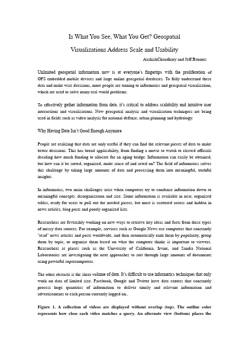
Is What You See, What You Get? GeospatialVisualizations Address Scale and UsabilityAashishChaudhary and Jeff BaumesUnlimited geospatial information now is at everyone’s fingertips with the proliferation of GPS-embedded mobile devices and large online geospatial databases. To fully understand these data and make wise decisions, more people are turning to informatics and geospatial visualization, which are used to solve many real-world problems.To effec tively gather information from data, it’s critical to address scalability and intuitive user interactions and visualizations. New geospatial analysis and visualization techniques are being used in fields such as video analysis for national defense, urban planning and hydrology.Why Having Data Isn’t Good Enough AnymorePeople are realizing that data are only useful if they can find the relevant pieces of data to make better decisions. This has broad applicability, from finding a movie to watch to elected officials deciding how much funding to allocate for an aging bridge. Information can easily be obtained, but how can it be sorted, organized, made sense of and acted on? The field of informatics solves this challenge by taking large amounts of data and processing them into meaningful, truthful insights.In informatics, two main challenges arise when computers try to condense information down to meaningful concepts: disorganization and size. Some information is available in neat, organized tables, ready for users to pull out the needed pieces, but most is scattered across and hidden in news articles, blog posts and poorly organized lists.Researchers are feverishly working on new ways to retrieve key ideas and facts from these types of messy data sources. For example, services such as Google News use computers that constantly "read" news articles and posts worldwide, and then automatically rank them by popularity, group them by topic, or organize them based on what the computer thinks is important to viewers. Researchers at places such as the University of California, Irvine, and Sandia National Laboratories are investigating the next approaches to sort through large amounts of documents using powerful supercomputers.The other obstacle is the sheer vo lume of data. It’s difficult to use informatics techniques that only work on data of limited size. Facebook, Google and Twitter have data centers that constantly process huge quantities of information to deliver timely and relevant information and advertisements to each person currently logged on..Figure 1. A collection of videos are displayed without overlap (top). The outline color represents how close each video matches a query. An alternate view (bottom) places thevideos on top of each other in a stack, showing only the strongest match result.Informatics is a key tool, but it’s not enough to simply find these insights that explain the data. Geospatial visualization bridges the gap from computer number-crunching to human understanding. If informatics is compared to finding the paths in a forest, visualization is like creating a visual map of those paths so a person can navigate through the forest with ease.Most people today are familiar with basic geospatial visualizations such as weather maps and Web sites for driving directions. The news media are starting to test more-complex geospatial visualizations such as online interactive maps to help navigate politicians’ stances on issues, exit polls and precinct reports during election times. People are just beginning to see the impact that well-designed geospatial visualizations have on their understanding of the world..Geospatial Visualization in the Real WorldPeople have been looking at data for decades, but the relevant information that accompanies the data has changed in recent years. In late 1999, Esri released a new software suite, ArcGIS, that could use data from various sources. ArcGIS provides an easy-to-use interface for visualizing 2-D and 3-D data in a geospatial context. In 2005, Google Earth launched and made geospatial visualization available to the general public.Geospatial visualization is becoming more significant and will continue to grow as it allows people to look at the totality of the data, not just one aspect. This enables better understanding and comprehension, because it puts the data in context with their surroundings. The following three cases demonstrate geospatial visualization use in real-world scenarios:1. Urban PlanningPlanners use geomodeling and geovisualization tools to explore possible scenarios and communicate their design decisions to team members or the general public. For example, urban planners may look at the presence of underground water and the terrain’s surrounding topology before deciding to build a new suburb. This is relevant for areas around Phoenix, for example, where underground water presence and proximity to a knoll or hill can determine the suitability of a location for construction.Figure 2. Videos from the same location are partially visible, resembling a stack of cards. Each video is outlined by the color representing the degree to which it matches the query.Looking at a 3-D model of a house with its surroundings gives a completely different perspective than just looking at the model of a house by itself. This also can help provide clear solutions to problems, such as changing the elevation of a building’s base to make it stand better.Urban planning is one of the emerging applications of computer-generated simulation. Cities’ rapid growth places a strain on natural resources that sustain growth. Water management, in particular, becomes a critical issue.The East Valley Water Forum is a regional cooperative of water providers east of Phoenix, and it’s designing a water-management plan for the next 100 years. Water resources in this region come from the Colorado River, the Salt River Project, groundwater, and other local and regional water resources. These resources are affected directly and indirectly by local and global factors such as population, weather, topography, etc.To best understand the relationship among water resources and various factors, the Arizona Department of Water Resources analyzes hydrologic data in the region using U.S. Geological Survey MODFLOW software, which simulates the status of underground water resources in the region. For better decision making and effective water management, a comprehensive scientific understanding of the inputs, outputs and uncertainties is needed. These uncertainties include local factors such as drought and urban growth.Looking at numbers or 2-D graphs to understand the complex relationship between input, output and other factors is insufficient in most cases. Integrating geospatial visualizations with MODFLOW simulations, for example, creates visuals that accurately represent the model inputs and outputs in ways that haven’t been previously presented.For such visualizations, two water surfaces are positioned side-by-side—coming from two different simulations—with contour lines drawn on top. In this early prototype, a simple solution—providing a geospatial plane that can be moved vertically—brings the dataset into a geospatial context. This plane includes a multi-resolution map with transparency. Because these water layers are drawn in geospatial coordinates, it matches exactly with the geospatial plane. This enables researchers to quickly see the water supplies of various locations.2. Image and Video AnalysisDefense Advanced Research Projects Agency launched a program, Video and Image Retrieval nd Analysis Tool (VIRAT), for understanding large video collections. The project’s core requirement is to add video-analysis capabilities that perform the following:• Filter and prioritize massive amounts of archived and strea ming video based on events.• Present high-value intelligence content clearly and intuitively to video analysts.• Reduce analyst workload while increasing quality and accuracy of intelligence yield.Visualization is an integral component of the VIRAT system, which uses geospatial metadata and video descriptors to display results retrieved from a database.Analysts may want to look at retrieval result sets from a specific location or during a specific time range. The results are short clips containing the object of interest and its recent trajectory. By embedding these results in a larger spatiotemporal context, analysts can determine whether a retrieved result is important.3. Scientific VisualizationU.S. Army Corps of Engineers’ research organ ization, the Engineer Research and Development Center, is working to extend the functionality of the Computational Model Builder (CMB) environment in the area of simulation models for coastal systems, with an emphasis on the Chesapeake and Delaware bays.The CMB environment consists of a suite of applications that provide the capabilities necessary to define a model (consisting of geometry and attribute information) that’s suitable for hydrological simulation. Their simulations are used to determine the impact that environmental conditions, such as human activities, have on bodies of water.Figure 3. Google Earth was used to display Chesapeake Bay’s relative salt (top) and oxygen (bottom) content (higher concentrations in red).One goal is to visualize simulation data post-processed by CMB tools. Spatiotemporal information, for example, is included in oxygen content and salinity data. Drawing data in geospatial context lets users or analysts see which locations are near certain features, giving the data orientation and scale that can easily be understood. Figure 3 shows the oxygen and salt content of Chesapeake Bay, where red shows higher concentrations and blue shows lower concentrations.Moving ForwardVisualizations that can be understood at all levels will be key in politics, economics, national security, urban planning and countless other fields. As information becomes increasingly complex, it will be harder for computers to extract and display those insights in ways people can understand.More research must be done in new geospatial analysis and visualization capabilities before we drown in our own data. And it’s even more important to educate people in how to use and interpret the wealth of analysis tools already available, extending beyond the basic road map.High schools, colleges and the media should push the envelope with new types of visuals and animations that show data in richer ways. The price of explaining these new views will be repaid when audiences gain deeper insights into the real issues otherwise hidden by simple summaries. Progress isn’t limited by the volume of available information, but by the ability to consume it.翻译:你所看到的,你得到了什么?地理空间可视化的处理规模和可用性作者:AashishChaudhary和包密斯·杰夫无限的空间信息现在就在每个人的指尖,其与扩散的嵌入式GPS移动设备和大型网上地理空间数据库。
GIS专业英语词汇Alogrithm:算法;Pixel:像元Accuracy:准确度;Plotter:绘图仪;Application:应用;Polygon:多边形ArtificialIntelligence(AI):人工智能;Precision:精度;Aspect:方位Proximityanalysis:邻近分析Attribute:属性;Query:查询;Binary:二进制;Recode:重编码:系数据库;Booleanoperation:布尔*作(逻辑*作)Relationaldatabase关Buffer:缓冲区;Sitesuitabilityanalysis:位置适宜度分Cartography:制图学;析Cell:单元;Spatialaccuracy:空间准确度;Chain:链Spatialanalysis:空间分析Continuousdata:连续数据Spatialprecision:空间精度;Coordinatesystem:坐标系统Spatialrelationship:空间关系Database数:据库;Subset:子集;Databaseapproach:数据库方法Terrainanalysis:地形分析Databasemanagementsystem(DBMS):Thematicmap:专题地图;数据库管理系统Topology:拓扑Dataentry:数据输入;TrackingGIS:动态GIS;Dataset:数据集UTM(UniversalTransverseMercator):Datastandards数:据标准;通用横轴麦卡托投影Datastructure:数据结构Node:结点;Datavisualization:数据可视化;Vertex:节点Deriveddata:派生数据Viewshed:可视域Originaldata:原始数据;vector矢量Digitize:数字化;merge合并Digitizer:数字化仪slope溢出Discretedata:离散数据;terrain地形Distributedsystem:分布式系统infrastructure基础设施Fractal:分形;dynamic动态的Geocoding:地理编码(地址编码)sequence顺序Georeferenced地:理参考;cumulative积累Landinformationsystem(LIS):土地信outline大纲息系统horizon视野Mapalgebra:地图代数;substantial真实的Mapprojection:地图投影paradigm范例Mapscale:地图比例尺;perceptions理解Metadata:元数据integrated完整的Overlay:叠置;analog类似物Parcel:地块coherence连贯的Peripherals:外设;impairing削弱面tentative延伸的trendsurface趋势holographic透视的designate描绘currency流行的discrete离散ultimate终极unambiguous明确的z ones尺度utilities公共事业tabular表格的sparse稀少distribution分配coordinate坐标标abarchart直方图i con图depicted描述configuration参数scale比例尺clustered群聚的retrieval检索l unarcrater火山口spatial空间的termed术语为⋯⋯census人口puchhydrologic水文的assembled集中的function功能configuration配置buffer缓冲的cutting-edge前沿temporal暂时terrific极端critical关键的overlay叠加demographic人口统计的accomplishment技巧vary改变thematic主题s pan跨度tremendously非常的eruption火山爆发multidisciplinary多学科的hazard灾难holistic整体的frame结构hub轴心erosive侵蚀dimensional维数animation动态peripheral外设obsolete荒废的innovative创新的extrapolated推断的interdisciplinary交叉学科preliminary预备的competent有能力的address反映attribute属性spreadsheet电子表格interchanged相互交换synergy协同reference参照物grid栅格constitute组成trait特点sphere球cartography制图core中心diverse不同的identification区别magnitude数量sample采样surveyedsite测量点proximity相近的statisticalanalysis数据分析latitude经度query查询longitude纬度滤landscape外观filter过descend下降polygon多边形option选择scope范围drag拖perimeter周长WOED格式redundancy冗余arc弧duplication复制view视图查询inspected检accommodate查decimal十进制outline轮廓arbitrary随意的hence从此以后robust增强coordinateposition坐标位置dedicate致力于border边界even偶数evolution发展rectangular矩形exaggerated放大的rasterization栅格化curve曲线magnifictionfangdajagged锯齿状的unaidedeye肉眼plotter绘图仪coarse粗糙demonstrate演示resolution分辨率relevant相关crude粗糙moderate中等digitized数字化stack大量linear直线manipulate*作triangle三角形cancel抵消adjacent临近的compensate补偿ends端点topology拓扑的bends拐点intuitive直觉vertice顶点versus与⋯⋯相对node节点seamless无缝的segment段。
GIS专业英语Abscissa 横坐标absolute accuracy 绝对精度absolute coordinates 绝对坐标Absorption 吸收abstraction 抽取accuracy 精度Add Data 添加数据Across-track scanner 跨径扫描仪active remote sensing 主动遥感Address geocoding 地址地理编码address locator地址定位器Address matching 地址匹配agreement licensee 协议被许可人Advanced Very High Resolution Radiometer 高级甚高分辨率辐射仪Air station 航摄站alidade照准仪along-track scanner 沿径扫描仪Alphanumeric grid 字母数字网格Anaglyph 视差立体图analog image模拟图像Analysis mask 分析掩模anisotropy各向异性Antipode对跖点apogee远地点Arc 弧architecture 架构archive档案argument参数Arithmetic expression 算术表达式aspatial data 非空间数据aspect ratio纵横比Astrolabe 星盘atlas grid地图集网格atmospheric window大气窗口Atomic clock 原子钟attenuation 衰减authentication 身份验证author 作者Autocorrelation 自相关automated cartography 自动化制图automation scale 自动化比例Autovectorization 自动矢量化axis 轴azimuthal projection 方位投影Backscatter 后向散射band 波段band ratio 波段比band-pass filter 带通滤波器Bandwidth 带宽bar scale比例尺(图形比例尺) base layer 底层base station基站Batch 批量batch geocoding 批量地理编码batch processing 批处理Batch vectorization 批量矢量化bathymetric curve 等深线battleships grid战舰网格Bayesian statistics 贝叶斯统计bearing方位角Bézier curve 贝塞尔曲线Bilinear interpolation 双线性内插法binding绑定binomial distribution 二项式分布Biogeography 生物地理学blind digitizing 盲目数字化block group街区群Block kriging 块段克里金法bookmark 书签boolean 1.布尔数据类型; 2.布尔值Boolean operator 布尔运算符boundary边界boundary line 界线Boundary monument 界标boundary survey 边界测量bounding rectangle边界矩形Bowditch rule 包狄法则break point 断点breakline断裂线browser 浏览器Buffer area 缓冲区business logic 业务逻辑CAD 计算机辅助设计(computer-aided design)Cadastral survey 地籍测量cadastre 地籍calibration 校准,定标callout line标注线Camera station 摄站capacity容量cardinal point方位基点cardinality基数Cartesian coordinate system 笛卡尔坐标系cartogram 统计图cartographer 制图员Cartography 制图学cartouche地图饰框catalog tree 目录树catchment流域Categorical raster 类目栅格celestial sphere天球cell size栅格大小cells 栅格Cellular automaton 元胞自动机census block人口普查区块Census geography人口普查地理学center 中心点centerline中心线centerpoint中点Central meridian中央子午线centroid 重心chart 图表chi-square statistic卡方统计Choropleth map 面量图chroma色度chronometer 天文钟circle圆Circular variance 圆方差civilian code民用码Clarke Belt克拉克带Clarke ellipsoid 克拉克椭球Clarke spheroid 克拉克椭球面Clearinghouse(信息或服务)交换中心clinometric map坡度图code-phase GPS 码相位GPS Cognitive map认知图coincident重叠cokriging协同克里金法command 命令Command line 命令行compass north罗经北compass point 罗经点compass rose罗经盘Compass rule罗盘仪法则compression program 压缩程序Computational geometry计算几何学Containment 包含Conformal projection 等角投影,保角投影,正形投影conformality保形性Conic projection 圆锥投影conjoint boundary共同边界constant azimuth恒定方位Content Standard for Digital Geospatial Metadata 数字地理空间元数据的内容标准Continuous raster 连续栅格contour 等高线,等值线contour drawings 等高线图,等值线图Contour interval 等高线间距,等值线间距contour line等高线,等值线Contour tagging 等高线标注,等值线标注contrast ratio 对比度Contrast stretch 对比度扩展convergence angle收敛角conversion转换Convex hull 凸包coordinate geometry坐标几何学coordinate system 坐标系Coordinated universal time 协调世界时correlation相关Corridor analysis走廊分析, 廊道分析county subdivision县级分区Covariance 协方差Coverage 1.覆盖面;2.ESRI图层Cracking 裂化Crandall rule Crandall 法则crop guide 裁切参考线crop marks 裁切标记Cross correlation 交叉相关cross covariance 交叉协方差cross tabulation 交叉表Cross validation 交叉验证Cross variogram交叉变差函数Cubic convolution立方卷积插值法cultural feature人文要素Cultural geography文化地理学curb approach路边通道curve fitting曲线拟合Customizations 自定义cylindrical projection圆柱投影Dangle length悬线长度Dangle tolerance 悬线容差dangling arc 悬弧Dasymetric mapping分区制图(多用于人口数据)data management 数据管理Data table 数据表dataset 数据集datum基准DBMS 数据库管理系统(data-base management system) Dead reckoning 航位推测法Declination 1.偏角;2.磁偏角degree slope坡度Delaunay triangulation 德洛内三角Delimiter 分隔符demography人口统计学Densify 增密densitometer密度计Density slicing 密度分割deploy 部署或安装(硬件、软件等)Depression contour 洼地等高线depth contour等深线Depth curve 深度曲线Descending node 降交点Desire-line analysis期望线分析desktop 桌面Desktop clients 桌面客户端Desktop GIS 桌面GIS destination目标Determinate flow direction确定性流向Deterministic model 确定性模型Detrending 趋势分离developable surface可展表面developer 开发人员Development environment 开发环境Diazo process重氮晒印法difference 差异Differential correction 差分校正Differential Global Positioning System 差分全球定位系统Diffusion 扩散Digital elevation model 数字高程模型Digital Geographic Information Exchange Standard 数字化地理信息交换标准Digital Geographic Information Working Group 数字地理信息工作组Digital image processing 数字图像处理Digital line graph 数字线划图Digital nautical chart 数字海图Digital number 数值Digital orthophoto quadrangle 数字正射影像图Digital orthophoto quarter quadrangle 数字正射影像象限图Digital raster graphic 数字栅格图digital terrain elevation data 数字地形高程数据Digital terrain model 数字地形模型digitizer数字化仪Dijkstra’s algorithm狄捷斯特拉算法dilution of precision精度衰减因子Dimension 尺寸,维,维度directed network flow有向网络流Direction 方向Dirichlet tessellation荻瑞斯莱特镶嵌,荻瑞斯莱特剖分Discovery 发现discrete data离散数据discrete digitizing离散数字化Discrete raster 离散栅格数据Displacement 位移display scale显示比例Display unit显示单位dissemination扩散,传播distance距离Distance decay距离衰减Distance unit距离单位Distortion变形district 地区Dithering 抖动Diurnal arc周日弧docking停靠Doppler shift多普勒位移Doppler-aided GPS 多普勒辅助GPS dot density map点密度图Dot distribution map 点分布图double precision双精度Double-coordinate precision 双坐标精度Douglas-Peucker algorithm 道格拉斯-普克算法downstream下游Drafting 描绘draping叠加,披盖drift漂移drive-time area驾车时间区Drop-down list 下拉列表drum scanner鼓式扫描仪Dual Independent Map Encoding 双重独立坐标地图编码Dynamic zoom 动态缩放Easting 东距eccentricity 偏心率ecliptic 黄道edge边Edgematching 边缘匹配elastic transformation弹性变形Electromagnetic spectrum 电磁光谱electronic atlas电子地图集element 元素Electronic navigational chart 电子航海图Elevation guide 高程指南ellipsoid 椭球体Ellipticity 椭圆率End offset 末端偏移endpoint 端点enterprise GIS 企业级GIS Entity objects 实体对象envelope包络矩形environmental model 环境模型Ephemeris 星历表equal competition area平等竞争区equal-area classification等积分类Equal-area projection 等积投影equal-interval classification等距分类Equatorial plane 赤道面equidistant projection等距投影ESRI Data ESRI 数据Event 事件exponent指数export导出exposure station 摄站expression表达式Extended 扩展extent范围extrapolation 外插法extrude 拉伸extrusion拉伸Face 平面false easting 东移假定值false northing北移假定值feature 要素Federal Geographic Data Committee 美国联邦地理数据委员会field 字段Fill 填充fillet圆角filter过滤器,过滤flow direction流向flow map流向图Focal analysis邻域分析focal functions邻域函数form 地形,形式fractal 分形Framework 框架frequency 频率from-node 起点Full Extent 完整范围Fuzzy boundary 模糊边界Fuzzy classification 模糊分类fuzzy set 模糊集合Fuzzy tolerance 模糊容差Gauss-Krüger projection 高斯-克吕格投影Generalization 概化,(数据库或地图的)综合技术Geocentric coordinate system 地心坐标系geocode地理编码geocoding 地理编码Geocomputation 地理计算geodata 地理数据geodatabase 地理数据库Geodatabase data model 地理数据库数据模型Geodataset 地理数据集Geodesic 测地线Geodetic 测地学geographic coordinate system 地理坐标系Geographic information science 地理信息学Geographic Information System (GIS) 地理信息系统(GIS)Geography 地理学geography level 地理等级Geography Markup Language地理标记语言Geoid 大地水准面geoid-ellipsoid separation大地水准面-地球椭球面分离Geolocation 几何定位geometric coincidence 几何重叠Geometric correction 几何校正Geometric dilution of precision 几何精度衰减因子Geometric network 几何网络Geometric transformation 几何变换Geometry 几何学geomorphology 地貌学Geoprocessing 地理处理Georectification地理校正Georeference 地理参考Georeferencing 地理参考georelational data model 地理相关数据模型Geospatial data 地理空间数据geospatial data clearinghouse 地理空间数据交换中心Geospatial technology 地理空间技术Geospecific model 地学相关模型Geostationary 对地静止geostatistics地理统计学geosynchronous 对地同步Geotypical model 典型地理模型GIS地理信息系统GIScience地理信息学Global Navigation Satellite System 全球卫星导航系统Global Positioning System 全球定位系统GUI GUI (图形用户界面)Global spatial data infrastructure 全球空间数据基础架构Glyph 字形gnomonic projection日晷投影Go to ǿȀ转至ǿȀGPS 全球定位系统Grad 梯度(原英文单词可能有误) gradian 梯度gradient 坡度,斜率graticule 经纬网Gravimeter 重力计gravimetric geodesy 大地重力学gravity model 引力模型Gray scale 灰度great circle 大圆Greenwich mean time格林尼治标准时间Greenwich meridian格林尼治子午线grid 网格grid cell网格单元ground 大地,地面Hachure 晕渲线Hamiltonian circuit汉密尔顿回路Hamiltonian path汉密尔顿路径Height 高度Helmert transformation 线性正形变换hemisphere半球Heuristic 试探算法,试探函数hexadecimal 十六进制High Accuracy Reference Network高精度基准网High Precision Geodetic Network高精度大地基准网Hillshading 坡面阴影,晕渲histogram equalization直方图均衡化Hole 孔洞Horizontal geodetic datum 水平大地基准human geography 人文地理学Hydrography 水文地理学hydrologic cycle水循环hydrology水文学hyperlink 超链接Hypsography 测高学,地势图hypsometric curve等高线hypsometric map地势图Hypsometry 测高法Identify 识别identity link一致性链接illumination照度image coordinate图像坐标Image data 图像数据image division图像除法运算image scale 图像比例尺Image space 图像空间imager成像仪impedance阻抗import 导入IMS IMS (网络地图服务器,Internet Map Server) incident energy入射能量Index 索引index map索引图infrared scanner红外扫描仪Infrastructure 基础设施inset map插图instance 实例instantiation实例化Integer data 整数型数据integration 集成intensity 亮度Interactive vectorization 交互矢量化Interchange format 交换格式Interferogram干涉图intermediate data中间数据International date line 国际日期变更线international meridian国际子午线International Organization for Standardization 国际标准化组织Interpolation内插法interrupted projection分瓣投影intrinsic stationarity 内在稳态Inverse distance weighted interpolation 反距离加权内插法Irregular triangular mesh 不规则三角网Irregular triangular surface model 不规则三角面模型Isanomal 等地平Isarithm 等数线Isobar 等压线isochrone 等时线Isohyet 等雨量线Isolines 等值线isometric line 等容线isopleth 等值线isotherm等温线Isotropy无向性iteration 迭代iterative procedure迭代过程Jaggies 锯齿Jenks’ optimization詹克斯优化joint operations graphic 联合作战地图Junction element 交点元素Kernel 内核key identifier 主标识符kinematic positioning 动态定位Knockout 分离区(信号或通讯的中断) known point 已知点Kohonen map 柯霍南图Kriging 克里金法label标签labeling 标注lag 间隔land cover土地覆盖land information system土地信息系统land use土地利用landform 地形landmark 地标Landsat 陆地卫星landscape ecology景观生态学large scale 大比例尺lattice 点阵面layers 层layout 布局least squares 最小二乘法level 水平leveling 水平测量library 类库license 许可证license agreement 许可协议licensee 被许可人lidar 激光雷达line线line feature线要素line of sight 视线line simplification 线条简化line smoothing 线条平滑linear dimension 线性尺寸linear feature 线性要素linear interpolation 线性内插法linear referencing 线性参考(用于交通GIS) linear unit 线性单位localization 本地化location query 位置查询location-allocation 位置分配location-based services 基于位置的服务logarithm 对数logical network逻辑网络loop traverse 闭合导线loxodrome 恒向线Magnetic bearing 磁方位magnetometer 磁力计majority resampling 多数重新采样Map algebra 地图代数map collar地图边缘map display 地图显示Map document地图文档map element地图元素map extent地图范围Map feature 地图要素map generalization 地图概化,地图综合Map projection 地图投影Map query 地图查询map reading地图阅读map scale 地图比例尺map series地图系列Map service 地图服务map sheet地图map style地图风格map unit 地图单位Mapping 制图mask掩模mass point散点mathematical operator 数学运算符Matrix 矩阵mean center平均中心mean sea level 平均海平面Mean stationarity 平均稳态Measure 测量measure value 测量值Measurement residual 测量残差median中间数median center平均中心Mental map 意境图meridian子午线metadata 元数据Metropolitan statistical area 大都市统计区microdensitometer 测微密度计Micrometer 1.测微计; 2.微米minimum bounding rectangle 最小边界矩形Minimum map unit 最小地图单位minor axis短轴misclosure 闭合差Mitigation 减轻mobile clients 移动客户端Mobile GIS 移动GIS Model 模型Monument 标石morphology 形态学mosaic 镶嵌图mud pit 泥浆池Multichannel receiver 多频道接收器multidimensional data多维数据Multipart feature 多部分要素multipatch feature 带纹理要素Multiplexing channel receiver 多路复用频道接收器multipoint feature 多点要素Multispectral scanner 多光谱扫描仪multivariate analysis 多元分析My Places 我的位置National Spatial Data Infrastructure 美国国家空间数据基础设施Natural breaks classification 自然分类navigation 导航Navstar Navstar (美国国防部全球定位系统联合服务项目)Neighborhood statistics 邻域统计networked 联网node 节点Noncoterminous polygon 非相连多边形nonversioned 非版本normal distribution 正态分布Normal probability distribution 正态概率分布northing 北距Oblate ellipsoid扁椭球体oblate spheroid扁椭球面offset 偏移Oill spill 溢油(原文oill 应为Oil) Online GIS 在线GISOpen Geodata Interoperability Specification 开放地理空间数据互操作规范Open Geospatial Consortium 开放地理空间协会open traverse 不闭合导线OpenGIS Consortium OpenGIS 协会OpenLS OpenLS (OpenGIS所包含的Open Location Service)Operand 运算数operator运算符optical center 光学中心ordinal data序数数据Ordinary kriging 普通克里金法ordinate 纵坐标Ordnance Survey 英国陆地测量局Orientation 方向origin point 原点orthogonal offset 正交偏移Orthographic 正交orthomorphic 正形orthophoto 正射影像Orthophotograph 正射影像orthophotoquad 无等高线正射影像overview map 总览图Orthophotoscope 正射投影仪orthorectification 正射校正outlier 异常值Outline vectorization 轮廓矢量化output data 输出数据Overlay 重叠Overprinting 套印Pan 平移panchromatic sharpening 全色锐化parallax bar 视差尺Parameter 参数parametric curve 参数曲线passive remote sensing 被动遥感Passive sensors 被动传感器Path 路径Pathfinding 路径搜寻peak山峰Percent slope 斜率perigee 近地点persistence 持久性photogeology 摄影地质学Photogrammetry 摄影测量学Photomap 摄影地图photometer光度计Physical geography 自然地理学pit 洼地,山谷placement 放置Planar coordinate system 平面坐标系planar enforcement 平面强化planarize平面化Plane 平面planimetric map 平面图planimetric shift 平面位移Platform 平台Plot 绘图plotter绘图仪plumb line铅垂线point 点point digitizing 点数字化Point event 点事件point feature 点要素point line 点线Point mode digitizing 点模式数字化point size点大小Point-in-polygon overlay 多边形内点重叠polar aspect 极方位坡向Polar flattening 极向扁率polar orbit 极轨道polar radius 极半径Policy and management 政策与管理Polygon overlay 多边形重叠Polyhedron 多面体Polyline 折线position位置postal code 邮政编码precision code 精确码Prime meridian 本初子午线prime vertical 东西圈probability map概率图Profile graph 剖面图projected coordinate system 投影坐标系Projective transformation 射影变换prolate ellipsoid 长椭球体property属性Proximity analysis 邻近分析pseudo node 伪节点pseudo-random number伪随机数Public Land Survey System美国公共土地测量系统pyramid金字塔QQ plot QQ 图quadrangle maps 梯形图幅quadrant象限quadrat analysis样方分析Quadtree 四叉树quantile 分位数quantile classification 分位数分类Quantile scatter chart 分位数散点图quantitative data 数量数据Quantitative geography 数量地理学query 查询Radar altimeter 雷达测高计Radar interferometry 雷达干涉测量Radian 弧度Radiation 辐射radio button 单选按钮radio waves 无线电波radiometer 辐射计Radiometric 辐射测量radius半径random noise随机噪声range范围,距离Range domain 范围域,距离域raster 栅格raster band栅格层raster cell 栅格单元Raster data model栅格数据模型Raster dataset band 栅格数据层Raster model 栅格模型Raster preprocessing 栅格预处理Raster snapping 栅格贴齐Raster tracing 栅格跟踪Rasterization 栅格化ratioing 比值法ray tracing 光线跟踪RDBMS 关系数据库管理系统reclassification 重分类Record 记录Record selector 记录选择器rectangular survey 矩形测量rectification 校正Rectilinear 直线,纵横线redistricting 重新区划reference data 参考数据Reference grid 参考网格Reference level 基准面Reference map 基准图Reference spheroid 参考椭球面Reference system 参考系统Referential integrity 参照完整性Reflectance 反射率reflected back 反射Region 地区,区域regression回归relational join 关系结合Relational operator 关系运算符relationship 关系relative accuracy相对精度Relative bearing 相对方位relative mode 相对模式relative path 相对路径Release of hazardous liquids 有害液体的泄漏relief efforts 救助Relief shading 地貌晕渲remote-sensing imagery 遥感图像Replaced hachuring 替代晕渲法replication 复制Representation 表示法,表现Representative fraction数字比例尺reprojection 重新投影resampling 重采样Residuals 残差resolution merging 分辨率融合restriction 限制Reverse geocoding 反地理编码rhumb line 恒向线ring 圆环ring study圆环分析River addressing 河道寻址rotation 旋转route路线row行R-tree R 树Satellite image 卫星图像satellite imagery 卫星图像saturation饱和度Scalable 可伸缩scale bar 比例尺scale factor 比例系数scale range 比例尺范围Scatter chart 散点图scene 场景,景(卫星图像单位) Schema 架构Seamless pan 无缝平移secant projection 正割投影section 弧段segment线段Self-organizing map 自组织影射图semantics 语义semimajor axis 半长轴Semiminor axis 半短轴semivariogram 半变差函数Sensitivity analysis 敏感度分析Sensor 传感器sequence 序列sequential analysis 顺序分析Serialization 序列化Server GIS 服务器GIS sextant 六分仪shaded relief image 晕渲地貌图Shaded relief map 晕渲地貌图shading 晕渲Shape 形状Shapefile 形状文件(ESRI数据格式) shield盾牌,(地质学)地盾shift位移Shortcuts 快捷方式short-range variation 短程变化signal 信号Signal-to-noise ratio 信噪比signature特征significance level 显著性水平Sill 基台simple kriging 简单克里金法simultaneous conveyance 同时传达Sink 端点,汇点site prospecting 选址分析slope坡度smooth 平滑Snapping tolerance 捕捉容差soil 土壤sonar 声纳soundex 语音编码算法Source 起点,源点source data 源数据space coordinate system 空间坐标系Spaghetti data 无位相数据spaghetti digitizing 无位相数字化spatial analysis 空间分析Spatial cognition 空间认知spatial data 空间数据Spatial Data Transfer Standard空间数据传输标准spatial database空间数据库Spatial join 空间结合spatial modeling 空间建模spatial overlay空间叠加Spatial query 空间查询spatial reference空间参考spatial weights matrix空间权重矩阵Spatialization 空间化spectral resolution 光谱分辨率spectral signature 光谱特征Spectrometer 光谱仪spectrophotometer分光光度计Spectroscopy 光谱学Spectrum 光谱sphere球体spheroid 椭球面,椭球体spider diagram蛛网图Spike 尖峰,异常线spline 样条函数spot 点spurious polygon 伪多边形Standard deviation 标准偏差Standard Generalized Markup Language 标准通用标记语言Standard Industrial Classification codes 标准工业分类代码Star diagram 星形图state状态state plane coordinate system 国家平面坐标系Static positioning 静态定位Stationarity 稳态Stationing 定位参考Statistical surface 统计表面steep 陡峭steradian 球面度Stereocompilation 立体测图Stereogrammatic organization 立体法结构Stereographic projection 球极平面投影Stereometer 体积计Stereomodel 立体模型Stereopair 立体像对Stereoplotter 立体绘图仪stochastic model 随机性模型stream digitizing 流数字化Stream mode digitizing 流模式数字化stream tolerance 流容差streaming 数据流Stretch 拉伸string 线段串,字符串Structure 结构study area 研究区域Surface fitting 曲面拟合surface model 曲面模型surround element 周边元素Survey marker 方位标survey monument方位标survey station测点Symbol 符号Tangent projection 切面投影taskbar 任务栏temporal data 时态数据Temporal GIS 时态GIS territory 地域Tessellation 网格化textbox 文本框Texture 纹理thematic map 专题地图theodolite 经纬仪Thiessen polygons 泰森多边形Thinning 细化third normal form 第三范式three-dimensional shape 三维形状Three-tier configuration 三层结构threshold ring analysis 阈值环分析Tidal datum 潮位基准面tie point 连接点tie survey 连接测量Tissot indicatrix 天梭指示线tolerance 容差toolbar 工具栏,工具条toolbox 工具箱Tools toolbox 工具工具箱topographic contours 地形等高线topography地形学, 地形Topological overlay 拓扑重叠Topology error 拓扑误差toponym 地名tour巡回路线Township 镇区tracing 跟踪tracking data 跟踪数据tract 人口普查区transaction事务Transformation 变换transit rule 过渡法则translation平移,转换Transverse aspect横轴法投影traverse 导线triangulated irregular network 不规则三角网Triangulation 三角测量trilateration 三边测量true bearing 真实方位true curve 真实曲线True north 真北tuple 元组turn impedance转弯阻抗turn-by-turn maps多段显示地图Tutorial 教程uninitialized flow direction 未初始化的流向United States Geological Survey 美国地质勘测局univariate distribution 一元分布Universal kriging 通用克里金法universal polar stereographic 通用极球面投影坐标网Universal Soil Loss Equation 通用土壤流失方程universal time 世界时Universal transverse Mercator 统一横轴墨卡托投影upstream 上游Urban geography 城市地理学Urban Vector Map 城市矢量图Valency 度validation验证variable 变量variance 方差Variance-covariance matrix 方差协方差矩阵 Variogram 变差函数Variography 变差法Vector 矢量vectorization 矢量化verbal scale 言语比例尺Vertex 顶点Vertical axis 纵轴vertical coordinate system 垂直坐标系Vertical exaggeration 垂直夸大Vertical geodetic datum垂直大地基准Vertical photograph 垂直航拍图viewshed 视域visible scale range 可见比例范围Visual center 视觉中心visual hierarchy 视觉层次visualization可视化V oronoi diagram V oronoi 图V oxel 三维像素Warping 变形waterfall model 瀑布模型Watershed 分水岭Wavelength 波长wavelet compression 小波压缩wayfinding 路线搜寻Waypoint 路点Web clients Web 客户端Web-enabled 支持Web Weight 权重Weighted mean center 加权平均中心weighted moving average 加权移动平均Weighted overlay 加权重叠weird polygon 复杂多边形well 水井World 世界Windowing 窗口Wireframe 线框workbook 工作簿,练习册workflow 工作流Zenithal projection 天顶投影zonal analysis 区域分析zonal functions 区域函数zone of interpolation 内插区zoning 分区zoom 缩放。
accreditation 委派accuracy 准确度acquisition 获取activity patterns 活动模式added value 附加值adjacency邻接Aeolian 伊奥利亚人的, 风的, 风蚀的Age of Discovery 发现的年代aggregation聚合algorithm, definition算法,定义ambiguity 不明确analytical cartography 分析制图application programming interfaces(APIs) 应用编程接口ARCGis 美国ESRI公司开发的世界先进的地理信息系统软件ArcIMS 它是个强大的,基于标准的工具,让你快速设计和管理Internet地图服务ArcInfo 在ArcGIS软件家族中,ArcInfo是GIS软件中功能最全面的。
它包含ArcView和ArcEditor 所有功能,并加上高级空间处理和数据转换ArcNews 美国ESRI向用户终生免费赠送的ArcNews报刊ArcSDE ArcSDE在ESRI GIS软件和DBMS之间提供通道,是一个空间数据引擎ArcUser Magazine 为ESRI用户创建的报刊ArcView 桌面GIS和制图软件,提供数据可视化,查询,分析和集成功能,以及创建和编辑地理数据的能力ARPANET ARPA 计算机网(美国国防部高级研究计划局建立的计算机网)aspatial data 非空间数据?Association of Geographic Information (AGI) 地理信息协会attribute data 属性数据attributes, types 属性,类型attributive geographic data 属性地理数据autocorrelation 自相关Autodesk MapGuide 美国Autodesk公司生产的Web GIS软件Automated mapping/facility management(AM/FM) systems 自动绘图/设备管理系统facilities 设备avatars 化身A VIRIS 机载可见光/红外成像光谱仪azimuthal projections 方位投影batch vectorization 批量矢量化beer consumption 啤酒消费benchmarking 基准Berry, Brianbest fit line 最优线binary counting system 二进制计算系统binomial distribution 二项式分布bivariate Gaussian distribution 二元高斯分布block encoding 块编码Bosnia, repartitioning 波斯尼亚,再分离成两个国家buffering 缓冲区分析Borrough, PeterBusiness and service planning(retailing) application in petroleum and convenience shopping 石油和便利购物的业务和服务规划(零售)应用business drivers 业务驱动business, GIS as 业务,地理信息系统作为Buttenfield, Barbaracadasters 土地清册Callingham, Martincannibalizing 调拨Cartesian coordinate system笛卡尔坐标系Cartograms 统计地图cartographic generalization 制图综合cartographic modeling 地图建模cartometric transformations 量图变换catalog view of database 数据库目录视图census data人口普查数据Census of Population 人口普查central Place Theory 中心区位论central point rule 中点规则central tendency 中心倾向centroid 质心choropleth mapping分区制图choosing a GIS 选择一个地理信息系统class 类别classification generalization 分类综合client 客户端client-server C/S结构客户端-服务器cluster analysis 聚类分析clutter 混乱coastline weave 海岸线codified knowledge 编码知识COGO data 坐标几何数据COGO editing tools 坐标几何编辑工具Collaboration 协作Local level 地方级National level 国家级Collection-level metadata 获取级元数据Commercial-off-the-shelf (COTS) systems 成熟的商业化系统chemas-microsoft-comfficeffice" />>> Commom object request broker architecture (CORBA) 公共对象请求代理体系结构Community, GIS 社区,地理信息系统Competition 竞争Component GIS 组件地理信息系统Component object model (COM) 组件对象模型Computer assisted mass appraisal (CAMA) 辅助大量估价,>>Computer-aided design (CAD)-based GIS 基于计算机辅助制图的地理信息系统Models 数据模型Computer-aided software engineering (CASE) tool 计算机辅助软件工程工具Concatenation 串联Confidence limits 置信界限Conflation 异文合并Conformal property 等角特性Confusion matrix 混淆矩阵Conic projections 圆锥投影Connectivity 连接性Consolidation 巩固Constant term 常数项Contagious diffusion 传染扩散Continuing professional development (CPD) 持续专业发展Coordinates 坐标Copyright 版权Corridor 走廊Cost-benefit analysis 成本效益分析Cost-effectiveness evaluation 成本效率评估Counting method 计算方法Cresswell, PaulCustomer support 客户支持Cylindrical Equidistant Projection 圆柱等距投影Cylindrical projections 圆柱投影> >Dangermond, Jack 美国ESRI总裁>> dasymetric mapping 分区密度制图>>data 数据>>automation 自动化>>capture costs 获取代价>>capture project 获取工程>>collection workflow 采集工作流>> compression 压缩>>conversion 转换>>definition 定义>>geographic, nature of 地理数据,数据的性质>> GIS 地理信息系统>>industry 产业>>integration 集成>>mining 挖掘>>transfer 迁移>>translation 转化>>data model 数据模型>> definition 定义>>levels of abstraction 提取等级>> in practice 实际上>>types 类型>>database 数据库>>definition 定义>>design 设计>>generalization 综合>>global 全球的>>index 索引>>multi-user editing 多用户编辑>> structuring 结构>>database management system (DBMS) 数据库管理系统>>capabilities 能力>>data storage 数据存储>>geographic extensions 地理扩展>>types 类型>>Dayton Accord 达顿协定,1995年12月达顿协定(DAYTON ACCORD)签订,巴尔干和平已经实现,波斯尼亚(包括黑塞哥维那)再被分解成两个国家>>decision support 决策支持>>deductive reasoning 演绎推理>>definitions of GIS 地理信息系统的各种定义>>degrees of freedom 自由度>>density estimation 密度估算>>dependence in space 空间依赖>>desktop GIS 桌面地理信息系统>>desktop paradigms 桌面范例>>Digital Chart of the World (DCW) 世界数字化图>>digital divide 数字鸿沟>>Digital Earth 数字地球>>Digital elevation models (DEMs) 数字高程模型>>Digital line graph (DLG) 数字线划图>>Digital raster graphic (DRG) 数字影像图>>Digital representation 数字表现>>Digital terrain models 数字地形模型>>Digitizing 数字化>>DIME (Dual Independent Map Encoding) program 美国人口调查局建立的双重独立地图编码系统>> Dine CARE >>Discrete objects 离散对象>>Douglas-Poiker algorithm 道格拉斯-普克算法,一种矢量数据抽稀算法>>Dublin Core metadata standard 都柏林核心元数据标准>>Dynamic segmentation 动态分割>>Dynamic simulation models 动态仿真模型>>> >Easting 朝东方>>Ecological fallacy 生态谬误>>e-commerce 电子商业>>editing 编辑>>education 教育>>electromagnetic spectrum 电磁光谱>>ellipsoids 偏振光椭圆率测量仪>>of rotation 旋转的>>emergency evacuation 应急撤退>>encapsulation 封装>>environmental applications 环境应用>>environmental impact 环境影响>>epidemiology 流行病学>>equal area property 等面积特性>>Equator 赤道>>ERDAS ERDAS公司是世界上最大的专业遥感图像处理软件公司,用户遍布100多个国家,软件套数超过17000套。
地理信息系统专业英语(全书翻译)
引言
本书是一本关于地理信息系统(Geographic Information System,简称GIS)专业英语的全书。
本书旨在帮助研究GIS的学生和从业
人员提高他们的英语听说读写技能,使他们能够流利地进行专业交
流和文献阅读。
全书内容包括以下几个部分:
第一部分:地理信息系统基础
本部分介绍了地理信息系统的基本概念和原理,包括地理数据、地图投影、地理空间分析等内容。
通过研究本部分的内容,读者可
以了解GIS的基础知识,并掌握相关的专业英语表达。
第二部分:地理信息系统应用领域
本部分介绍了地理信息系统在不同应用领域的具体应用,包括
土地利用规划、城市规划、环境保护等。
读者可以了解不同领域中
的GIS应用案例,并研究相关的专业英语表达。
第三部分:地理信息系统技术与工具
本部分介绍了地理信息系统的常用技术和工具,包括GIS软件、地理数据库、数据采集与处理等。
读者可以了解不同的GIS技术和
工具,并研究相关的专业英语表达。
第四部分:地理信息系统发展趋势与挑战
本部分介绍了地理信息系统的发展趋势和挑战,包括云计算、
大数据、人工智能等新技术对GIS的影响。
读者可以了解GIS领域的最新发展动态,并研究相关的专业英语表达。
结论
本书通过全面介绍地理信息系统的相关知识,帮助读者提高英
语水平和专业素养。
读者通过学习本书,可以更好地理解和应用地
理信息系统,并与国际同行进行有效的交流。
测绘工程专业英语1. Introduction测绘工程是一门综合性较强的学科,需要使用专业的英语术语来进行交流和沟通。
本文将介绍一些与测绘工程相关的常用英语词汇和表达,以帮助读者更好地理解和运用专业英语。
2. Surveying and Mapping 测绘2.1 Surveying 规划测量•Geodetic surveying大地测量•Cadastral surveying (land) 地籍测绘•Engineering surveying工程测量•Topographic surveying地形测量•Control surveying控制测量•Hydrographic surveying水文测量•Deformation monitoring变形监测2.2 Mapping 制图•Cartography制图学•Digital mapping数字制图•Geographic information system (GIS)地理信息系统•Remote sensing遥感•Image interpretation图像解译•Orthophoto正射影像•Contour lines等高线•Land cover classification土地覆盖分类3. Instruments and Equipment 仪器设备•Theodolite经纬仪•Total station全站仪•GPS receiver GPS接收机•Levels水准仪•Laser scanner激光扫描仪•Data collector数据采集器•GIS software GIS软件•Mapping software制图软件4. Measurements 测量数据•Distance measurement距离测量•Angle measurement角度测量•Coordinate measurement坐标测量•Elevation measurement高程测量•Height measurement高度测量•Area measurement面积测量•Volume measurement体积测量5. Data Analysis 数据分析•Data processing数据处理•Error analysis误差分析•Statistical analysis统计分析•Spatial analysis空间分析•Data visualization数据可视化•Interpolation插值•Extrapolation外推•Regression analysis回归分析6. Project Management 项目管理•Survey project planning测量项目规划•Budget estimation预算估算•Resource allocation资源分配•Scheduling进度安排•Quality control质量控制•Risk assessment风险评估•Project documentation项目文档7. Conclusion本文介绍了一些与测绘工程专业相关的英语词汇和表达,涵盖了测绘、制图、仪器设备、测量数据、数据分析和项目管理等领域。
ArcGIS 9 ArcToolbox 中英文对照表分析(analysis)注记(annotation)注记要素类(annotation feature class)注记对象(annotation target)属性(attribute)障碍(barrier)绘图(cartography)数据框(data frame)字段(field)障碍(barrier)数据库(database)数据集(dataset)范围(extent)组合要素(multipart feature)图形比例尺(scalebar)空间分析(spatial analysis)符号(symbol)3D Analyst Tools 三维分析工具转换ConversionTIN 三角计算TIN 域值TIN 多边形标志TIN 节点TIN 边TIN 到栅格栅格转TINFunctional Surface 表面功能插值形状表面体积表面点表面长度视线Raster Interpolation 栅格修补克里金地形到栅格曲线拟合用文件地形到栅格自然邻域趋势距离权重倒数Raster Math乘减加取整浮点除Raster Reclass切片查找用ASCII 文件重分类用表重分类重分类Raster Surface坡向坡度填/挖山影曲率栅格计算栅格重分类栅格表面等高线等高线列表观察点视域TIN Creation创建TIN编辑TINTIN SurfaceTIN 坡度TIN 方位TIN 等高线多边形插值成多个面Analysis Tool:ExtractClipSelectSplitTable Select OverlayEraseIdentityIntersect TIN 创建TIN 表面分析工具提取剪切选择拆分表选择叠加分析擦除查看相交Symmetrical Difference 对称差UnionUpdate ProximityBufferMultiple RingBufferNearPoint Distance StatisticsFrequencySummaryStatistics联合更新邻域分析缓冲区多环缓冲区临近点距离统计表频度总结统计Cartography Tool:Masking ToolsCul-De-SacMasks 绘图工具掩模工具Cul-De-Sac 掩模Feature Outline Masks 要素轮廓线掩模Intersecting Layers Masks 相交图层掩模Conversion Tool:From RasterRaster to ASCII 转换工具从删格到...删格到ASCIIRaster to FloatRaster to PointRaster to PolygonRaster to Polyline To CADAdd CAD FieldsCreate CAD XDataExport to CADSet CAD AliasTo Coverage删格到浮点删格到点删格到面删格到线到CAD添加CAD 字段创建CAD 扩展实体数据导出到CAD设置CAD 别名到CoverageFeature Class To Coverage 要素类到CoverageTo dBASE 到dBASETable to dBASE [multiple] 表到dBASETo GeodatabaSEFeature Class To Feature Class要素类到要素类Feature Class to Geodatabase [multiple] 要素类到GeodatabaseImport CAD AnnotationImport Coverage AnnotationImport from CADRaster To Geodatabase[multiple]Table to Geodatabase[multiple]Table To TableTo Raster 到栅格ASCII to Raster ASCII 到栅格DEM to Raster DEM 到栅格Feature to Raster 要素到栅格Float to Raster 浮点到栅格导入CAD 注记导入Coverage 注记从CAD 导入栅格到Geodatabase 表到Geodatabase 表到表Raster To Other Format 栅格到其他格式To Shapefile 到ShapefileFeature Class To Shapefile 要素类到Shapefile Coverage Tool: Coverage 工具AnalysisExtractClipSelectSplitOverlayErase 分析提取剪切选择拆分叠加擦除IdentityIntersectUnionUpdate Proximity判别相交联合更新邻近BufferNearPoint DistancePoint NodeThiessen Conversion 转换From CoverageExport To DLG缓冲近邻点距离点到结点泰森近似多边形从Coverage到DLGExport To Interchange File 到Interchange 文件Export To S57Export To SETSExport To VPFUngenerateTo Coverage到S57到SETS到VPF取消生成到CoverageAdvanced Tiger Conversion 高级Tiger 转换Basic Tiger Conversion 基本Tiger 转换GenerateImport From DLG 生成从DLG 导入Import From Interchange File 从Interchange 文件导入Import From S57Import FromSETSImort From VPF Data ManagementAggregateAppend从S57 导入从SETS 导入从VPF 导入数据管理集合追加Composite Features 要素合成Line Coverage To Region 线Coverage 到区域Line Coverage To Route 线Coverage 到路径Polygon Coverage To Region 多边形Coverage 到区域Region To Polygon Coverage 区域到多边形Coverage Generalization 一般Aggregate Polygons 聚集多边形Collapse Dual Lines To Centerline 分解双线到中心线Dissolve EliminateFind Conflicts Simplify Building 融合消除查找冲突简化建筑物Simplify Line Or Polygon 简化线或多边形IndexesDrop IndexIndex Item ItemsAdd ItemDrop Item 索引项删除索引索引项添加项删除项Joins Join Info Tables Projections 连接 投影连接 Info 表 Define Projection Project Transform Tables 表 Add XY Coordinates Renumber Nodes Update IDs Tolerances 容差 Tolerance Topology 拓扑 Build Clean Create Labels VPF Tile Topology 定义投影投影变换 添加 XY 坐标重新计数节点更新 ID容差构建Clean创建标注VPF 图块拓扑Workspace Management 工作空间管理Create Coverage Data Management Tools 数据管理工具 Database 数据库 Compact Compress Disconnected Editing 分离编辑 Check In Check In From Delta Check Out Export To Delta Domains 值域 Add Coded Value To Domain Assign Domain To FieldCreate Domain创建 Coverage紧凑 压缩检入 从增量中检入 检出 导出增量 添加编码值到值域 赋值值域到字段 创建值域 Delete Coded Value From Domain 从值域中删除编码值 Delete Domain Domain To Table Remove Domain From Field Set Value For Range Domain Table To Domain Feature class 要素类删除值域值域到表从字段删除值域为范围值域设置值表到值域Append Annotation Feature Classes 追加注记要素类 Calculate Default Cluster Tolerance 计算缺省容限值Calculate Default Spatial Grid Index 计算缺省空间格网索引 Integrate 整合Update Annotation Feature Class 更新标记要素类创建要素类Features 要素创建要素类Add XY Coordinates Check Geometry Copy Features Delete Features 添加XY 坐标检查几何形状复制要素删除要素Feature Envelope to Polygon 要素封装到多边形Feature To LineFeature To PointFeature To PolygonFeature Vertices To PointsMultipart To SinglepartPolygon To LineRepair GeometrySplit Line At Vertices Fields 字段Add FieldAssign Default To FieldCalculate FieldDelete FieldGeneral 一般CopyDeleteRenameSelect Data追加Generalization 一般DissolveEliminateSimplify LineSmooth LineIndexes 索引Add Attribute IndexAdd Spatial IndexRemove Attribute IndexRemove Spatial Index Joins 连接Add JoinRemove Join 要素到线要素到点要素到多边形要素定点到点多部分到单部分多边形到线修改集合形状在定点拆分线添加字段设置缺省到字段计算字段删除字段复制删除重命名选择数据追加融合消除简化线平滑线添加属性索引添加空间索引删除属性索引删除空间索引添加连接删除连接Layers and Table Views 图层和表的查看Make Query TableMake Raster Catalog Layer Make Raster Layer 制作查询表制作栅格目录图层制作栅格图层Make XY Event Layer Save To Layer File Select Layer By Attribute Select Layer By Location 制作表视图制作要素图层制作XY 事件图层保存成图层文件通过属性选择通过位置选择制作表视图制作要素图层Projections and Transformations 投影和转换FeatureBatch ProjectProject创建空间参考RasterFlipMirrorProject RasterRescaleRotateShiftWarDefine ProjectionRasterBatch BuildPyramids 栅格要素批量投影投影创建空间参考栅格翻转镜像投影栅格重建比例旋转偏移翘曲定义投影批量建立金字塔Batch Calculate Statistics Build Pyramids Calculate StatisticsClipComposite BandsCopy RasterCopy Raster Catalog Items Create Raster Catalog 批量计算统计表建立金字塔计算统计表剪切组合波段复制栅格复制栅格目录项创建栅格目录Delete Raster Catalog Items 删除栅格目录项Mosaic To NewRasterResample创建栅格数据集镶嵌Relationship Classes 关系类镶嵌到新的栅格重采样创建栅格数据集镶嵌Create Relationship Class 创建关系类Table To Relationship Class 表到关系类SubtypesAdd SubtypeRemove SubtypeSet Default SubtypeSet Subtype Field Table 子类型表添加子类型删除子类型设置缺省子类型设置子类型字段Analyze Change Privileges Copy Rows Delete Rows Get Count Pivot Table 创建表 Topology 拓扑分析改变权限复制行删除行获得数目关联表创建表Add Feature Class To Topology 添加要素类型到拓扑 Add Rule To Topology Create Topology 添加规则到拓扑创建拓扑Remove Feature Class From Topology 从拓扑删除要素类 Remove Rule From Topology Set Cluster Tolerance Validate Topology Versions 版本 Alter Version Create Version Delete Version Post Version Reconcile Version Register As Versioned Unregister As Versioned Workspace 工作空间 Create ArcInfo Workspace Create Feature Dataset Create Folder Create Personal GDB 从拓扑中删除规则设置簇容限值教验拓扑 改变版本创建版本删除版本提交版本协调版本注册版本取消注册创建 ArcInfo 工作空间创建要素数据集创建文件夹创建个人 Geodatabase Geocoding Tools Automate Geocoding IndexesCreate Address Locator地理编码工具自动生成地理编码索引创建地址定位器 Deautomate Geocoding Indexes Delete Address Locator Geocode Addresses Rebuild Geocoding Indexes Standardize Addresses 取消自动生成地理编码索引 删除地址定位器地理编码地址重建地理编码索引 标准化地址 Geostatistical Analyst Tools 地理统计分析工具Geostatistical Layer To Grid 导出地理统计图层到 Grid Linear Referencing Tools Calibrate Routes Create Routes Dissolve Route Events 线性参考工具校准路径创建路径融合路径事件Locate Features Along Routes 沿路径定位要素边界清理Make Route Event LayerOverlay Route EventsTransform Route EventsSpatial Analyst ToolsConditional 条件拾取条件设空Density 密度核密度点密度线密度Distance 距离代价分配代价回联代价距离代价路径欧几里德分配欧几里德方向欧几里德距离走廊路径距离路径距离分配路径距离回联Extraction 提取提取值到点根据属性提取用圆提取用多边形提取用掩模提取用点提取用矩形提取采样Generalization 一般区块组合多数过滤收缩消蚀细化聚合膨胀制作路径事件图层空间分析工具叠加路径事件转换路径事件Groundwater粒子跟踪达西流达西速率透水层Hydrology下陷点填充捕捉汇流点河流分级河流到要素河流连接流向流域流程盆地累积流量Interpolation克里金地形到栅格曲线拟合用文件地形到栅格自然邻域趋势距离权重倒数Local像素统计分级合成大于频率小于频率普及度最低位置最高位置等于频率Map Algebra单输出地图代数多输出地图代数MathBitwise位与位右移位否位异或地下水水文添补本地地图代数数学计算为运算左位移按位或Logical不等于为空大于大于等于小于小于等于测试等于组合与组合异或组合或逻辑与逻辑否逻辑异或逻辑或TrigonometricATan2余弦双曲余弦双曲正切双曲正弦反余弦反双曲余弦反双曲正切反双曲正弦反正切反正弦正切正弦10 的对数10 的指数2 的对数2 的指数上取整下取整乘减加取整否平方逻辑运算三角函数平方根指数整除浮点绝对值自然对数自然指数除MultivariateIsocluster主成分创建特征最大似然性分类波段组统计类概率系统树图功能编辑署名函数Neighborhood块统计点统计焦点流焦点统计线统计过滤Overlay加权叠加Raster Creation创建常量栅格创建正态栅格创建随机栅格Reclass切片查找用ASCII 文件重分类用表重分类重分类Surface坡向坡度填/挖山影曲率等高线等高线列表多元多变量邻域叠加栅格创建重分类表面观察点视域Zonal区域几何区域几何到表区域填充区域统计区域统计到表面积制表Spatial Statistics Tools Analyzing Patterns 区域空间统计工具分析模型Average Nearest Neighbor 平均邻近邻居High/Low Clustering[Getis-Ord General G]高/低聚类Spatial Autocorrelation [Morans I] 空间自相关Mapping Clusters 绘制群体Cluster and Outlier Analysis 群体和群外要素分析Cluster/Outlier Analysis with Rendering 带渲染群体和群外要素分析Hot Spot Analysis [Getis-Ord Gi*] 热点分析Hot Spot Analysis with Rendering 带渲染热点分析Measuring Geographic Distributions 测量地理分布Central FeatureDirectional DistributionLinear Directional MeanMean CenterStandard DistanceUtilities 实用工具Calculate AreasCollect EventsCollect Events with RenderingCount Rendering 中心要素定向分布平均线方向平均中心标准间隔距离计算面积收集事件带渲染收集事件计算渲染Export Feature Attribute to Ascii 导出要素表到Ascii 文本Z Score Renderine湖南师范大学资源环境科学学院GIS 研究中心周亮二00 四年十一月二十四日。
GIS专业英语教学教材G I S专业英语第⼀课Comprehensive:全⾯的,综合的,Intellectual:智⼒的,才智的Jargon:专业术语Terminology:专业术语Geomatique:地理信息技术Geoscience:地球科学Derivative:派⽣物,衍⽣物Cartography:地图绘制学,地图绘制Architect:建筑师Preliminary:初步的,起始的Enumerate:列举,枚举Resemble:像,与……相似Transformation:转换第⼆课Automated:⾃动化的Equivalent:a等价的Cartographer:绘制图表者,制图师Mylar:胶⽚Electronic:电⼦的Encode:编码Orthophotoquad:正射影像图Aerial:空中的,航空的Aggregation:集合,聚合,集合体Reproduction:再现,复制,繁殖Dissemination:传播,宣传,传染Counterpart:相似之物Compactness:致密性Complexity:复杂,复杂性Hamper:阻碍,束缚Retrieval:取回,恢复,修补Analog:模拟的Planimeter:测⾯器,求积仪Phenomena:现象Quantitative:数量的,定量的Histogram:直⽅图,柱状图Supplementally:追加,补充Modification:修改,变型Cartogram:统计地图,统计图Hand-drawn:⼿绘Emergency:紧急事件Employe:雇佣,雇⼯Clarify:澄清,阐明Taxonomy:分类学,分类法Bifurcation:分歧,分叉Parcel:地块Conservation:保存,保持Procurement:获得,取得,采购Wildlife:野⽣动植物Earthquake:地震Landslide:泥⽯流,⼭崩Cadastral:地籍的,有关⼟地清册的Geodetic:⼤地测量学,最短线的Sophisticated:精致的,复杂的第三课Pervade:弥漫,遍及Aspect:坡向,⽅向,⾯貌Inevitable:必然的,不可避免的Proprietary:所有的,专利的Mineral:矿物的,矿质的Military:军队,军⼈Electricity:电⼒,电流Telecommunication:通讯,电信学Interconnect:使相互连接,相互联系Administrative:管制的,⾏政的Environmental:环境的,周围的Attribute:属性,特质Procedure:步骤,程序,⼿续Manipulation:操作,操纵,处理Historically:历史上地,Subsume:把…..归⼊,把…..包括在Eclipse:形成蚀,使黯然失⾊Visualization:可视化,Immense:巨⼤的,⼴⼤的Analogue:类似,相似物Conventional:常见的,惯例的Enquire:询问,打听Coniferous:松柏科的Highlight:强调,突出,Stress:强调,加压⼒与Derive:得到,源于Discipline:纪律,学科,惩罚Algorithm:算法,Interpret:说明,⼝译,解释Artificial:⼈造的,仿造的,虚伪的Geomatique:地理信息技术Cartography:地图绘制学,地图绘制Preliminary:初步的,起始的Cartographer:绘制图表者,制图师Encode:编码Aggregation:集合,聚合,集合体Retrieval:取回,恢复,修补Analog:模拟的Quantitative:数量的,定量的Histogram:直⽅图,柱状图Cartogram:统计地图,统计图Parcel:地块Geodetic:⼤地测量学,最短线的Cadastral:地籍的,有关⼟地清册的Attribute:属性,特质Procedure:步骤,程序,⼿续Prime meridian:本初⼦午线Algorithm:算法,Discipline:纪律,学科,惩罚Visualization:可视化,Globe;球体Map projection地图投影Planar projection;平⾯投影Azimuthal projection;⽅位投影Characteristic,特征,特性Reference globe;参考椭球体Scale factor;⽐例因⼦Principle scale;主⽐例尺Equivalent projection;等积投影Equidistant;等距投影Mercator transverse;横轴莫卡托投影Gnomonic protection;中⼼切⾯投影Lambert‘s equal area projection 兰伯特等级⽅位投影Intelligence:智⼒,理解⼒,Correlation:相关,关联Urban:城市的Agriculture:农业,农艺Adjunct:附属物,修饰语Subdiscipline:学科的分⽀,副学科第四课Globe;球体Illustrate;阐明Configuration;配置,结构,外形Thematic;主题的Encounter;遭遇;邂逅Map projection地图投影Cylindrical;圆柱形的Projection family;投影系Planar projection;平⾯投影Cylindrical projection;圆柱投影Conical projection;圆锥投影Azimuthal projection;⽅位投影Community,社区,团体Representation;表现,陈述Characteristic,特征,特性Retain;保持,记住Convert;使转变Reference globe;参考椭球体Principle scale;主⽐例尺Scale factor;⽐例因⼦Cardinal 主要的,基本的Angular conformity;⾓度⼀致Conformal;等⾓的Orthomorphic;正形的Equivalent projection;等积投影Fundamental;基本的Equidistant;等距投影Maintain;维持,维修,供养Standard parallel;标准纬线Vital;⽣死攸关的,⾄关重要的Preservation;保存,保留Mercator transverse;横轴莫卡托投影Shopping mall ;⼤卖场Lambert‘s equal area projection 兰伯特等级⽅位投影Stereographic;⽴体照相的Orthographic;直⾓的Georeference;地理坐标参考系Universal transverse Mercator;通⽤横莫卡托投影Data type;数据类型,资料类型Attribute;属性,性质Vector;⽮量Raster:光栅Langscape;地表,地形Vertex;顶点,头顶Arc;弧形物,弧Node;节点Topology;拓扑学Vector-raster conversion⽮量-栅格转换Quadtree;四叉树Computer-aided drafting;计算机辅助制图Orthophoto;正⾊摄影Map algebra地图代数Forestry stand;林地,林区Inappropriate;不适当的,不相称的Quantized:量化的Legend:传奇,图例Vegetation:植物,草⽊Geological:地质的Spatial:空间分析技术Binary:⼆元的,⼆进制的Residence:居住,住处Variable:易变的,多变的Run-length code:长度⽅向编码Subsystem:⼦系统Pattern:样式,模式Scheme:模式,设计Database:数据库Resolution:解析,决议Entity:实体Spaghetti model:⾯条模型Topological model:拓扑模型Coordinate:坐标From node:终点Intersect:交叉,相交Form node:起始点Graph theory:图论Analog:模拟地图Compact:紧密的Reduction:缩减,降低Codification:编码,译成代码Shorthand:速记法Theme:题⽬,主题Scheme:模式,计划Gnomonic protection;中⼼切⾯投影Coordination;对等,同等第五课Georeference;地理坐标参考系Ellipsoid;椭圆,椭⾯Department of defence;国防部Universal transverse Mercator;通⽤横莫卡托投影第六课Thematic;题⽬的,主题的Facilitate;促进,帮助Data type;数据类型,资料类型Animation;活泼⽣⽓,激励Attribute;属性,性质Narration;叙述,讲述Vector;⽮量Raster;光栅Image;影像,肖像Photograph;照⽚,相⽚Langscape;地表,地形Vertex;顶点,头顶Arc;弧形物,弧Node;节点Connectivity;连通性,互联性Topology;拓扑学Mathematical;数学的,数学上的Adjacency;毗邻,四周Computer-aided drafting;计算机辅助制图Gridcell;格⽹单元Tesseate;棋盘格⽹的Quadtree;四叉树Data volume;数据卷Cumbersome;笨重的Vector-raster conversion⽮量-栅格转换Imperative;必要的,势在必⾏的Map algebra地图代数Modeling;造型的Distinguish;区别,区分Orthophoto;正⾊摄影Ancillary;辅助的,Rectify;改正Summarize;总结,概述Aesthetically;审美的Continuous;连续的,持续的。
1.Activity patterns 活动模式2.Added value 附加值3.Analytical cartography 分析制图4.Application programming interfaces 应用编程接口5.Aspatial data 非空间数据6.Association of geographic information 地理信息协会7.Attribute data 属性数据8.Attribute representation and transformation 属性表现和转9.Attributive geographic data 属性地理数据10.Availability and accessibility 可用性和可获取性11.Azimuthal projections 方位投影12.Batch vectorization 批量矢量化13.Beer consumption 啤酒消费14.Benchmarking 基准15.Binary counting system 二进制计算系统16.Binomial distribution 二项式分布17.Bivariate gaussian distribution 二元高斯分布18.Block encoding 块编码19.Brian best fit line 最优线20.Capture costs 获取代价21.Capture project 获取工程22.Cartesian coordinate system笛卡尔坐标系23.Cartograms 统计地图24.Cartographic generalization 制图综合25.Cartographic modeling 地图建模26.Cartometric transformations 量图变换27.Catalog view of database 数据库目录视图28.Census data人口普查数据29.Census of population 人口普查30.Central place theory 中心区位论31.Central point rule 中点规则32.Central tendency 中心倾向33.Choropleth mapping分区制图34.Classification procedures 分类过程35.Cluster analysis 聚类分析36.Coastline weave 海岸线37.Codified knowledge 编码知识38.Collection workflow 采集工作流39.Collection-level metadata 获取级元数据40.Commercial-off-the-shelf systems 成熟的商业化系统41.Component object model 组件对象模型42.Computer assisted mass appraisal 辅助大量估价"43.Computer-aided design-based geographic information systems 基于计算机辅助制图的地理信息系统44.Computer-aided software engineering tool 计算机辅助软件工程工具45.Confidence limits 置信界限46.Conformal property 等角特性47.Confusion matrix 混淆矩阵48.Conic projections 圆锥投影49.Consistency and quality 一致性和质量50.Constant term 常数项51.Contagious diffusion 传染扩散52.Content standards for digital geospatial metadata 数字地球空间元数据目录标准53.Continuing professional development 持续专业发展54.Cost-benefit analysis 成本效益分析55.Cost-effectiveness evaluation 成本效率评估56.Counting method 计算方法57.Cylindrical equidistant projection 圆柱等距投影58.Cylindrical projections 圆柱投影59.Dasymetric mapping 分区密度制图60.Data model 数据模型61.Data storage 数据存储62.Database management system 数据库管理系统63.Database management systems 数据库管理系统64.Decision support 决策支持65.Deductive reasoning 演绎推理66.Degrees of freedom 自由度67.Density estimation 密度估算68.Dependence in space 空间依赖69.Desktop geographic information systems 桌面地理信息系统70.Desktop paradigms 桌面范例71.Digital chart of the world 世界数字化图72.Digital divide 数字鸿沟73.Digital earth 数字地球74.Digital elevation models 数字高程模型75.Digital line graph 数字线划图76.Digital raster graphic 数字影像图77.Digital representation 数字表现78.Digital terrain models 数字地形模型79.DIME (dual independent map encoding) program 美国人口调查局建立的双重独立地图编码系统80.Discrete objects 离散对象81.Douglas-poiker algorithm 道格拉斯-普克算法,一种矢量数据抽稀算法82.Dublin core metadata standard 都柏林核心元数据标准83.Dynamic segmentation 动态分割84.Dynamic simulation models 动态仿真模型85.Ecological fallacy 生态谬误86.Electromagnetic spectrum 电磁光谱87.Emergency evacuation 应急撤退88.Environmental applications 环境应用89.Environmental impact 环境影响90.Equal area property 等面积特性91.Evacuation vulnerability 疏散的漏洞92.Evolution of 的演化93.Exploratory spatial data analysis 探测空间数据分析94.External validation 外部检验95.Federal geographic data committee 联邦地理数据协调委员会96.Finger-printing 指纹97.First law of geography 地理学第一法则98.First law of geography 地理学第一法则99.Fly-bys 飞行100.Forward sortation areas 由加拿大邮政编码前三位符号确定的地理范围101.Frame variogram 变异函数的框架102.Frequentist interpretations 频率论解释103.Friction values 摩擦力值104.Futures, geographic 未来,地理的105.Fuzzy approaches 模糊方法106.Fuzzy data analysis 模糊数据分析107.Fuzzy membership 模糊隶属108.Gap analysis 缝隙分析109.Gaussian distribution 高斯分布110.Geary index 基尔指数111.Genetic algorithms 遗传算法"112.Geographic data capture 地理数据获取113.Geographic data formats 地理数据格式114.Geographic data technology 地理数据技术115.Geographic database types 地理数据库类型116.Geographic extensions 地理扩展117.Geographic individual 地理个体118.Geographic information systems application servers 地理信息系统应用服务器119.Geographic information 地理信息120.Geographic names information system 地理名称信息系统121.Geographic problems 地理问题122.Geographic query and analysis 地理查询和分析123.Geographic representation 地理表现124.Geographical analysis machine 地理分析机125.Geography network 地理网络126.Geoinformation engineering 地理信息学工程127.Geological survey and defense mapping agency 地质测量和防卫制图机构128.Geological survey 地质测量129.Geoschematic visualization 地理视觉表现130.Geostationary orbit 与地球位置相对不变的轨道131.Global positioning system 全球定位系统132.Global spatial data infrastructure 全球空间数据基础设施133.Graphic symbols 图形符号134.Graphical data models 图形数据模型135.Graphical user interface 图形用户界面136.Great circle 大圆137.Grid index 网格索引138.Ground surveying 大地测量139.Half life 半衰期140.In practice 实际上141.In tax assessment 征税估价142.Indicator kriging 克利金法143.Inductive reasoning 归纳推理144.Information ownership 信息所有权145.Information science 信息科学146.Institute geographique national 国家地理所147.Intangible objectives 非明确目的148.Integrated development environment 集成开发环境149.Interaction modeling 交互模型150.Intercept term 拦截期限151.Interval attributes 间隔属性152.Inverse distance weighting 反距离权重法153.Invitation to tender 标案竞投154.Isopleth (isoline) maps 等值线地图155.Isotropic effects 等方性效果156.Knowledge economy 知识经济157.Knowledge of form 知识形式158.Kruger national park 克鲁格国家公园159.Lambert conformal conic projection 兰勃特等角圆锥投影160.Land information system 土地信息系统161.Landmark information system 地标信息系统162.Landsat thematic mapper sensor 陆地卫星163.Largest share rule 最大共享法则164.Levels of abstraction 提取等级165.Lifestyles data 生活方式数据166.Light metadata 轻量级元数据167.Linear distance decay 线性距离衰退168.Linear referencing systems 线性参考系统169.Living with 伴随…170.Local area network 局域网171.Local government 地方政府172.Local level 地方级173.Location-allocation problems 位置分配问题174.Location-based service 基于位置的服务175.Logical positivism 逻辑实证176.Market area analysis 市场区域分析177.Market penetration 市场渗透178.Martin cannibalizing 调拨179.Mean distance from the centroid 到质心的平均距离180.Mean square error 均方根误差181.Measurement error 测量误差182.Measurement of 误差测量183.Measurement scales 量测尺度184.Measuring degree 测量度185.Medieval art preservation 中世纪艺术保留" 186.Mercator projection 墨卡托投影187.Metric georeferences 公制地理参考188.Military maps 军用地图189.Military satellites 军用卫星190.Minimum aggregate travel 最小旅行距离191.Minimum bounding rectangle 最小外包矩形192.Minimum mapping unit 最小制图单元193.Model of geographic information systems innovation diffusion 地理信息系统创新扩散模型194.Modifiable areal unit problem 可变区域单元问题195.Moran index 莫然索引196.Move set 移动装置197.Multi-criteria decision-making 多标准决策支持198.Multiple objectives 多重目标199.Multiresolution seamless image database 多分辨率无缝的影像数据库200.Multi-user editing 多用户编辑201.Multivariate mapping 多元制图202.Napster napster公司文件交换软件203.National gap analysis program 国家缝隙分析计划204.National geospatial data clearinghouse (美国) 国家地球空间数据中心205.National grid of great britain 大不列颠国家网格206.National level 国家级207.National map accuracy standard 国家地图精度标准208.National mapping program 国家制图计划"209.National spatial data infrastructure 国家空间数据基础设施210.Navigation technologies 导航技术211.Negative autocorrelation 负自相关212.Network data model 网络数据模型213.Nominal attributes 名词属性214.Nominal case 名词格215.Nominal data 名词数据216.Nomothetic geography 以法律为依据的地理学217.Normative uses of geographic information systems 地理信息系统使用的标准化218.North american datum of 1983北美1983大地基准219.Null hypothesis 虚假设220.Object management group 对象管理组织221.Object-level metadata 对象级元数据222.Object-relational database management systems 对象关系型数据库管理系统223.Onstar system 移动信息系统224.Operational decisions 操作决策225.Operational navigation chart 操作导航图226.Optimized version 优化的版本227.Optimum paths 最优路径228.Ordinal attributes 顺序属性229.Ordinary least squares 最小二乘法230.Ordnance survey 全国地形测量231.Orienteering problem 定向运动问题232.Orthophotoquads 正射影象图233.Ownership of information 信息所有权234.Paper maps 纸质地图235.Paul customer support 客户支持236.Percent correctly classified 按正确率分类237.Per-pixel accuracy 像元精度238.Per-point accuracy 点精度239.Pessimistic locking 保守式锁定240.Photogrammetry 摄影测量241.Pie charts 饼图242.Pilot study 试点研究243.Planar projections 平面投影244.Planimeter method 测面计方法245.Planning assistance for superintendent scheduling 监督调度的规划协助246.Planning information system 规划信息系统247.P-median problem 中量问题248.Point in polygon 多边形内的点249.Point pattern analysis 点模式分析250.Polygon overlay 多边形叠置251.Positional error 定位误差252.Positive autocorrelation 正自相关253.Post codes 邮政编码254.Postal addresses 邮政地址255.Predictor variables 预报变量256.Pricing of geographical information 地理信息的定价257.Process knowledge 流程知识258.Professional geographic information systems 专业地理信息系统259.Public land survey system 公共土地测量系统260.Publishing industry 出版业261.Quadtree indexes 四叉树索引262.Quality of life 生活质量263.Radar topography mission 雷达地形测绘任务264.Raster compression techniques 栅格压缩技术265.Raster data capture 栅格数据获取266.Raster data model 栅格数据模型267.Raster overlay 栅格叠置268.Raster-based geographic information systems 基于栅格的地理信息系统269.Ratio attributes 比率属性270.Regression parameters 衰退参数271.Relational database management systems 关系数据库管理系统272.Relational databases 关系型数据库273.Relient energy 可靠性能源274.Remote sensing 遥感275.Representative fraction 典型的分形276.Request for proposals 请求提议277.Response variable 响应变量278.Routing problems 路径问题279.Rubber-sheeting 弹性伸缩280.Rule sets 规则集281.Run-length encoding 行程长度编码282.Sample frame 采样桢283.Sampling interval 采样间隔284.Satellite images 卫星影像285.Scale dependence 尺度依赖286.Scatterplot view of database 数据库散点图视图287.Schindler elevator corporation 迅达-电梯及自动扶梯公司288.Secant projections 切割投影289.Selective availability 选择可用性290.Self-similarity 自相似性291.Sierpinski carpet 施尔平斯基地毡292.Soil erosion 土壤侵蚀293.Spa marketing systems 温泉市场系统294.Space imaging 空间成像295.Spatial object representation and transformation 空间对象表现和转换296.Spatially aware professional 空间感知专业人员297.Species range maps 种类范围图298.Species richness maps 种类丰富图299.Spectral resolution 光谱分辨率300.Spurious polygon 乱真多边形301.Standard deviation 标准偏差302.Standard query language 标准查询语言303.State plane coordinates 美国平面坐标304.Statistical inference 统计推论305.Strategic decisions 战略决策306.Street centerline files 街道中心线文件307.Stripped-down metadata 分拆式元数据308.Subjectivist interpretations 主观解译309.SWOT analysis 优势(strength)、弱点(weakness)、机会(opportunities)、危机(threat)四点分析310.Symbolization generalization 符号综合311.Table view of dataset 数据集的表视图312.Tacit knowledge 默许知识313.Tactical decisions 战术决策314.Tangible objectives 切实目标315.Tax assessment 估税316.Temporal autocorrelation 时间自相关317.Temporal resolution 时间分辨率318.Terrain nominal 地形名词319.Theft of information 信息偷窃320.Thick client 胖客户端321.Thin client 瘦客户端322.Three-tier architecture 三层体系结构323.Time geography 时间地理324.Time-space geography 时空地理325.Topographic quadrangle maps 地形地图方格326.Topologic creation 拓扑建立327.Topologic dimension 拓扑维数328.Topologic properties 拓扑属性329.Topologically integrated geographic encoding and referencing files 集成图形地理编码参照文件330.Transactional databases 事务数据库331.Transverse mercator projection 横向墨卡托投影332.333.Tree indexes 树状索引334.335.Triangulated irregular network 不规则三角网336.Types and sources 类型和来源337.Unified modeling language 统一建模语言338.Universal polar stereographic projection 通用横球面投影339.340.Universal soil loss equation 全球土地流失方程341.342.Universal transverse mercator projection 全球横向墨卡托投影343.University consortium for geographic information science 地理信息系统大学委员会344.Unobserved predictor variables 未观测预报变量345.Unprojected projection 非预料投影346.User interaction 用户交互347.Using scanners 使用扫描仪348.349.Value adding 增值350.Vanessa layer 图层351.352.Vector data capture 矢量数据获取353.Vector data model 矢量数据模型354.355.Virtual reality 虚拟现实356.357.Visualization in scientific computing 科学计算可视化358.359.Water facility object data model 水设施对象数据模型360.361.Wavelet compression 小波压缩362.Wide area network 广域网"363.World wide web 万维网364.Worst-case scenario 最差情况365.Zero autocorrelation 零次自相关。
题型:一.关键词英译汉 20个汉译英10 二.关键句的翻译三.简答第一章绪论一.关键词英汉互译(1).attribute data 属性数据(2).continuous features 连续特征(3).discrete features 离散特征(4).Geographic information system地理信息系统(5)Geographic visualization 地理可视化(6).Georelational data model 地理关系数据模型(7)Object-based data model 基于对象的数据模型(8)Projection 投影(8)Raster data model 栅格数据模型(10) spatial data 空间数据(11).Topology 拓扑(12).Vector data model 矢量数据模型二.简答(1)Suppose you are required to do a GIS project for a class.What kinds of activities or operation do you have to perform to complete the project?Answer:spatial data input, attribute data management,data display, Data exploration,data analysis,GIS modeling第二章 coordinate System一.关键词英汉互译(1)Azimuthal projection 方位投影(2)Conformal projection 共形投影(3)Conic projection 圆锥投影(4)Cylindrical projection 圆柱投影(5)Datum 基准面(6)Latitude 纬度(7)longitude 经度(8)map projection 地图投影(9)Projected coordinate system 投影坐标系(10)Spheroid 椭球体二.简答(1)describe the four types of map projections by the preserved property? Answer:Azimuthal projection,Orthographic projection(正形),Equal-area projection(等积),Equidistant projection(等距离)(2).describe the three types of map projections by the projection or developable surface.Answer:Cylindrical projection,Conic projection,Planar projection(平面)三.翻译(1)Accuracy in a feature’s location and its relative position to other features is therefore a key consideration in the design of a projected coordinate system.汉:某种要素位置及其与其他要素相对位置的准确性是设计投影坐标系统所要考虑的重要因素(2)To maintain the level of accuracy desired for measurements,a projected coordinate system is often divided into different zones,with each zone defined by a different projection center.汉:为了达到所需的测量精度,一个投影坐标系统通常划分成不同的带,每个带有不同的投影中心.第三章georelational vector data model一.简答(1)explain the importance of topology in GIS.Answer:The first advantage is the assurance of data quality,second, topology can enhance GIS analysis.二.翻译(1).topology is the study of those properties of geometric objects that remain invariant under certain transformations such as bending or stretching汉:拓扑是研究几何对象在弯曲或拉伸等变换下仍保持不变的性质(2)The first advantage is the assurance of data quality.汉:首先是能保证数据质量的优点(3)second,topology can enhance GIS analysis其次,拓扑可强化GIS分析(4)first,they can display more rapidly on the computer monitor than topology-based data首先,非拓扑矢量数据能比拓扑数据更快速的在计算机屏幕上显示出来(5)second,they are nonproprietary and interoperable,meaning that they can be used across different software packages.汉:第二,非拓扑数据具有非专有性和互相操作性,这意味着非拓扑数据可以在不同软件之间通用。
用英语介绍地理信息科学专业的作文Geographic Information Science (GISc) is a multidisciplinary field that combines geography, computer science, and data analysis to study and understand the world around us. This branch of knowledge explores the ways in which we collect, store, analyze, and visualize geographic data to gain valuable insights into various phenomena.At the heart of GISc lies the concept of spatial data. In simple terms, spatial data refers to any information that has a location component attached to it. This may include coordinates, addresses, zip codes, or even satellite imagery. Through the use of specialized software and analytical techniques, GISc professionals can transform this raw data into meaningful knowledge.One of the fundamental applications of GISc is in mapping and visualization. Maps have always been an essential toolfor understanding spatial relationships and patterns. With the advent of GISc, mapping has become more than just lines and colors on paper. It has evolved into a powerful tool for decision-making and problem-solving.GISc provides a unique platform for integrating various data sources. It allows researchers and professionals to combine data from different domains, such as demographics, economics, and environmental science, into a single comprehensive framework. This integration unlocks the potential for uncovering hidden patterns and relationships that can inform policy-making and planning.Moreover, GISc plays a crucial role in addressing real-world challenges. It helps in managing natural resources, predicting and mitigating natural disasters, and planning urban development. By analyzing spatial data, GISc specialists can assess the impact of human activities on theenvironment and develop sustainable solutions for a better future.In recent years, GISc has witnessed groundbreaking technological advancements. The emergence of remote sensing, GPS, and mobile mapping has revolutionized the field. These technologies enable us to collect data at an unprecedented scale and accuracy, opening doors to new discoveries and applications.To excel in the field of GISc, one must possess a rangeof skills. Proficiency in computer programming, data analysis, and spatial modeling is essential. Additionally, a deep understanding of geography, cartography, and datavisualization techniques is crucial for effectively communicating results to diverse audiences.GISc professionals find employment opportunities invarious sectors. Government agencies rely on their expertiseto develop land use policies, manage transportation networks,and assess environmental impacts. Private companies utilize GISc applications for market analysis, site selection, and logistics optimization. Non-profit organizations harness the power of GISc to support conservation efforts, disaster response, and social justice initiatives.In conclusion, Geographic Information Science is a fascinating field that merges geography with cutting-edge technology. It empowers us to unlock the potential of spatial data and gain valuable insights into the world we inhabit. By harnessing the power of GISc, we can make informed decisions and shape a better future for generations to come.。
读书破万卷下笔如有神GIS专业英语词汇Alogrithm:算法;Accuracy:准确度;Application:应用;Artificial Intelligence(AI):人工智能;Aspect:方位Attribute:属性;Binary:二进制;Boolean operation:布尔*作(逻辑*作)Buffer:缓冲区;Cartography:制图学;Cell:单元;Chain:链Continuous data:连续数据Coordinate system:坐标系统Database:数据库;Database approach:数据库方法Database management system(DBMS):数据库管理系统Data entry:数据输入;Data set:数据集Data standards:数据标准;Data structure:数据结构Data visualization:数据可视化;Derived data:派生数据Original data:原始数据;Digitize:数字化;Digitizer:数字化仪Discrete data:离散数据;Distributed system:分布式系统Fractal:分形;Geocoding:地理编码(地址编码)Georeferenced:地理参考;Land information system(LIS):土地信息系统Map algebra:地图代数;Map projection:地图投影Map scale:地图比例尺;Metadata:元数据Overlay:叠置;Parcel:地块Peripherals:外设;Pixel:像元Plotter:绘图仪;Polygon:多边形Precision:精度;Proximity analysis:邻近分析Query:查询;Recode:重编码Relational database:关系数据库;Site suitability analysis:位置适宜度分析Spatial accuracy:空间准确度;Spatial analysis:空间分析Spatial precision:空间精度;Spatial relationship:空间关系Subset:子集;Terrain analysis:地形分析Thematic map:专题地图;Topology:拓扑Tracking GIS:动态GIS;UTM(Universal Transverse Mercator):通用横轴麦卡托投影Node:结点;Vertex:节点Viewshed:可视域vector 矢量merge 合并slope溢出terrain地形infrastructure 基础设施dynamic 动态的sequence 顺序cumulative积累outline大纲horizon视野substantial真实的paradigm范例perceptions理解integrated完整的analog类似物coherence 连贯的impairing 削弱tentative延伸的holographic 透视的currency 流行的ultimate终极utilities公共事业tabular表格的distribution 分配a bar chart直方图depicted描述scale比例尺retrieval 检索spatial空间的census人口puch assembled 集中的configuration配置cutting-edge 前沿terrific 极端overlay 叠加accomplishment 技巧thematic 主题tremendously 非常的multidisciplinary多学科的holistic 整体的hub轴心dimensional 维数peripheral外设innovative创新的interdisciplinary 交叉学科competent 有能力的attribute属性interchanged相互交换reference参照物constitute组成sphere球core中心identification区别sample采样proximity 相近的latitude经度longitude纬度landscape 外观polygon多边形scope范围perimeter周长trend surface趋势面designate 描绘discrete离散unambiguous明确的zones尺度sparse 稀少coordinate坐标icon图标configuration 参数clustered 群聚的lunar crater火山口termed 术语为……hydrologic水文的function功能buffer缓冲temporal 暂时的critical关键的demographic 人口统计的vary改变span跨度eruption火山爆发hazard灾难frame结构erosive侵蚀animation动态obsolete 荒废的extrapolated推断的preliminary 预备的address反映spreadsheet电子表格synergy协同grid栅格trait特点cartography制图diverse不同的magnitude数量surveyed site测量点statistical analysis 数据分析query查询filter过滤descend下降option选择drag 拖redundancy冗余duplication复制accommodate查询decimal 十进制arbitrary 随意的robust增强dedicate致力于even偶数rectangular矩形rasterization栅格化magnifictionfangda unaided eye肉眼coarse粗糙resolution分辨率crude粗糙digitized数字化linear直线triangle 三角形adjacent临近的ends端点bends 拐点vertice顶点node节点segment段arc弧view视图inspected检查outline轮廓hence从此以后coordinate position坐标位置border边界evolution发展exaggerated 放大的curve曲线jagged锯齿状的plotter绘图仪demonstrate 演示relevant相关moderate中等stack大量manipulate*作cancel抵消compensate补偿topology拓扑的intuitive直觉versus与……相对seamless无缝的。
Lesson 22 data analysis IIIntegrated Analytical Functions in a GISMost GIS's provide the capability to build complex models by combining primitive analytical functions. Systems vary as to the complexity provided for spatial modelling, and the specific functions that are available. However, most systems provide a standard set of primitive analytical functions that are accessible to the user in some logical manner. Aronoff identifies four categories of GIS analysis functions. These are :Retrieval, Reclassification, and Generalization;Overlay Techniques;Neighbourhood Operations; andConnectivity Functions.The range of analysis techniques in these categories is very large. Accordingly, this section of the book focuses on providing an overview of the fundamental primitive functions that are most often utilized in spatial analyses.Retrieval, Reclassification and GeneralizationPerhaps the initial GIS analysis that any user undertakes is the retrieval and/or reclassification of data. Retrieval operations occur on both spatial and attribute data. Often data is selected by an attribute subset and viewed graphically. Retrieval involves the selective search, manipulation, and output of data without the requirement to modify the geographic location of the features involved.Reclassification involves the selection and presentation of a selected layer of data based on the classes or values of a specific attribute, e.g. cover group. It involves looking at an attribute, or a series of attributes, for a single data layer and classifying the data layer based on the range of values of the attribute.Accordingly, features adjacent to one another that have a common value, e.g. cover group, but differ in other characteristics, e.g. tree height, species, will be treated and appear as one class. In raster based GIS software, numerical values are often used to indicate classes. Reclassification is an attribute generalization technique. Typically this function makes use of polygon patterning techniques such as crosshatching and/or color shading for graphic representation.In a vector based GIS, boundaries between polygons of common reclassed values should be dissolved to create a cleaner map of homogeneous continuity. Raster reclassification intrinsically involves boundary dissolving. The dissolving of map boundaries based on a specific attribute value often results in a new data layer being created. This is often done for visual clarity in the creation of derived maps. Almost all GIS software provides the capability to easily dissolve boundaries based on the results of a reclassification. Some systems allow the user to create a new data layer for the reclassification while others simply dissolve the boundaries during data output.One can see how the querying capability of the DBMS is a necessity in thereclassification process. The ability and process for displaying the results of reclassification, a map or report, will vary depending on the GIS. In some systems the querying process is independent from data display functions, while in others they are integrated and querying is done in a graphics mode. The exact process for undertaking a reclassification varies greatly from GIS to GIS. Some will store results of the query in query sets independent from the DBMS, while others store the results in a newly created attribute column in the DBMS. The approach varies drastically depending on the architecture of the GIS software.Topological OverlayThe capability to overlay multiple data layers in a vertical fashion is the most required and common technique in geographic data processing. In fact, the use of a topological data structure can be traced back to the need for overlaying vector data layers. With the advent of the concepts of mathematical topology polygon overlay has become the most popular geoprocessing tool, and the basis of any functional GIS software package.Topological overlay is predominantly concerned with overlaying polygon data with polygon data, e.g. soils and forest cover. However, there are requirements for overlaying point, linear, and polygon data in selected combinations, e.g. point in polygon, line in polygon, and polygon on polygon are the most common. Vector and raster based software differ considerably in their approach to topological overlay.Raster based software is oriented towards arithmetic overlay operations, e.g. the addition, subtraction, division, multiplication of data layers. The nature of the one attribute map approach, typical of the raster data model, usually provides a more flexible and efficient overlay capability. The raster data model affords a strong numerically modelling (quantitative analysis) modelling capability. Most sophisticated spatial modelling is undertaken within the raster domain.In vector based systems topological overlay is achieved by the creation of a new topological network from two or more existing networks. This requires the rebuilding of topological tables, e.g. arc, node, polygon, and therefore can be time consuming and CPU intensive. The result of a topological overlay in the vector domain is a new topological network that will contain attributes of the original input data layers. In this way selected queries can then be undertaken of the original layer, e.g. soils and forest cover, to determine where specific situations occur, e.g. deciduous forest cover where drainage is poor.Most GIS software makes use of a consistent logic for the overlay of multiple data layers. The rules of Boolean logic are used to operate on the attributes and spatial properties of geographic features. Boolean algebra uses the operators AND, OR, XOR, NOT to see whether a particular condition is true or false. Boolean logic represents all possible combinations of spatial interaction between different features. The implementation of Boolean operators is often transparent to the user.Generally, GIS software implements the overlay of different vector data layers by combining the spatial and attribute data files of the layers to create a new data layer. Again, different GIS software utilize varying approaches for the display andreporting of overlay results. Some systems require that topological overlay occur on only two data layers at a time, creating a third layer. This pairwise approach requires the nesting of multiple overlays to generate a final overlay product, if more than two data layers are involved. This can result in numerous intermediate or temporary data layers. Some systems create a complete topological structure at the data verification stage, and the user merely submits a query string for the combined topological data. Other systems allow the user to overlay multiple data layers at one time. Each approach has its drawbacks depending on the application and the nature of the implementation. Determining the most appropriate method is based on the type of application, practical considerations such as data volumes and CPU power, and other considerations such personnel and time requirements. Overall, the flexibility provided to the operator and the level of performance varies widely among GIS software offerings.The following diagram in Fingure 1 illustrates a typical overlay requirements where several different layers are spatially joined to created a new topological layer.By combining multiple layers in a topological fashion complex queries can be answered concerning attributes of any layer.Neighbourhood OperationsNeighbourhood operations evaluate the characteristics of an area surrounding a specific location. Virtually all GIS software provides some form of neighbourhood analysis. A range of different neighbourhood functions exist. The analysis of topographic features, e.g. the relief of the landscape, is normally categorized as being a neighbourhood operation. This involves a variety of point interpolation techniques including slope and aspect calculations, contour generation, and Thiessen polygons. Interpolation is defined as the method of predicting unknown values using known values of neighbouring locations.36 Interpolation is utilized most often with point based elevation data.Figure 2 illustrates a continuous surface that has been created by interpolating sample data points.Elevation data usually takes the form of irregular or regular spaced points. Irregularly space points are stored in a Triangular Irregular Network (TIN). A TIN is a vector topological network of triangular facets generated by joining the irregular points with straight line segments. The TIN structure is utilized when irregular data is available, predominantly in vector based systems. TIN is a vector data model for 3-D data.An alternative in storing elevation data is the regular point Digital Elevation Model (DEM). The term DEM usually refers to a grid of regularly space elevation points. These points are usually stored with a raster data model. Most GIS software offerings provide three dimensional analysis capabilities in a separate module of the software. Again, they vary considerably with respect to their functionality and the level of integration between the 3-D module and the other more typical analysis functions.Without doubt the most common neighbourhood function is buffering. Buffering involves the ability to create distance buffers around selected features, be it points,lines, or areas. Buffers are created as polygons because they represent an area around a feature. Buffering is also referred to as corridor or zone generation with the raster data model. Usually, the results of a buffering process are utilized in a topological overlay with another data layer. For example, to determine the volume of timber within a selected distance of a cutline, the user would first buffer the cutline data layer. They would then overlay the resultant buffer data layer, a buffer polygon, with the forest cover data layer in a clipping fashion. This would result in a new data layer that only contained the forest cover within the buffer zone. Since all attributes are maintained in the topological overlay and buffering processes, a map or report could then be generated.Buffering is typically used with point or linear features. The generation of buffers for selected features is frequently based on a distance from that feature, or on a specific attribute of that feature. For example, some features may have a greater zone of influence due to specific characteristics, e.g. a primary highway would generally have a greater influence than a gravel road. Accordingly, different size buffers can be generated for features within a data layer based on selected attribute values or feature types.Connectivity AnalysisThe distinguishing feature of connectivity operations is that they use functions that accumulate values over an area being traversed.37 Most often these include the analysis of surfaces and networks. Connectivity functions include proximity analysis, network analysis, spread functions, and three dimensional surface analysis such as visibility and perspective viewing. This category of analysis techniques is the least developed in commercial GIS software. Consequently, there is often a great difference in the functionality offered between GIS software offerings. Raster based systems often provide the more sophisticated surface analysis capabilities while vector based systems tend to focus on linear network analysis capabilities. However, this appears to be changing as GIS software becomes more sophisticated, and multi-disciplinary applications require a more comprehensive and integrated functionality. Some GIS offerings provide both vector and raster analysis capabilities. Only in these systems will one fund a full range of connectivity analysis techniques.Proximity analysis techniques are primarily concerned with the proximity of one feature to another. Usually proximity is defined as the ability to identify any feature that is near any other feature based on location, attribute value, or a specific distance. A simple example is identifying all the forest stands that are within 100 metres of a gravel road, but not necessarily adjacent to it. It is important to note that neighbourhood buffering is often categorized as being a proximity analysis capability. Depending on the particular GIS software package, the data model employed, and the operational architecture of the software it may be difficult to distinguish proximity analysis and buffering.The identification of adjacency is another proximity analysis function. Adjacency is defined as the ability to identify any feature having certain attributes that exhibit adjacency with other selected features having certain attributes. A typical example isthe ability to identify all forest stands of a specific type, e.g. specie, adjacent to a gravel road.Network analysis is a widely used analysis technique. Network analysis techniques can be characterized by their use of feature networks. Feature networks are almost entirely comprised of linear features. Hydrographic hierarchies and transportation networks are prime examples. Two example network analysis techniques are the allocation of values to selected features within the network to determine capacity zones, and the determination of shortest path between connected points or nodes within the network based on attribute values. This is often referred to as route optimization. Attribute values may be as simple as minimal distance, or more complex involving a model using several attributes defining rate of flow, impedance, and cost.Three dimensional analysis involves a range of different capabilities. The most utilized is the generation of perspective surfaces. Perspective surfaces are usually represented by a wire frame diagram reflecting profiles of the landscape, e.g. every 100 metres. These profiles viewed together, with the removal of hidden lines, provide a three dimensional view. As previously identified, most GIS software packages offer 3-D capabilities in a separate module. Several other functions are normally available. These include the following functions :user definable vertical exaggeration, viewing azimuth, and elevation angle;identification of viewsheds,e.g. seen versus unseen areas;the draping of features, e.g. point, lines, and shaded polygons onto the perspective surface;generation of shaded relief models simulating illumination;generation of cross section profiles;presentation of symbology on the 3-D surface; andline of sight perspective views from user defined viewpoints.While the primitive analytical functions have been presented the reader should be aware that a wide range of more specific and detailed capabilities do exist.。