全站仪在数字测图技术中应用
- 格式:doc
- 大小:221.00 KB
- 文档页数:28
全站仪和GNSS-RTK联合在数字测图中的应用摘要:目前地面数字测图一般都采用全站仪、GNSS-RTK或者两者结合。
全站仪测图具有精度高、使用方便等优点,而GNSS-RTK具有精度高、工作距离长和不存在误差累计等优势,为克服各自的不足,提出了数据采集中综合应用GNSS-RTK和全站仪的方法,开发设计了全站仪和GNSS-RTK集成的数字测图系统,利用实测数据对其进行验证。
针对集成中可能出现的问题给出解决办法和措施,得出有益的结论,可以借鉴到类似的工程中。
关键词:GNSS-RTK,全站仪,数字测图,地形测量0 引言传统地形测量具有测量环节繁琐、操作复杂、受测区环境、地形、地物以及人为操作的影响较大等不足,很多时候测量精度达不到要求,而数字测图具作业时间短、劳动强度轻和成果精度高等优点,能够实现信息采集处理的数字化和自动化。
采用全站仪进行数字测图作业效率高、提高成果的精度和改善野外作业环境,但在高山、林地、高大建筑物和海岛地区等特殊的观测环境,还会受到制约。
而随着GNSS系统的不断完善、逐步建成和计划的实施以及接收机灵敏度的不断提高,尤其是我国北斗在亚太地区的公开服务,目前其应用已经渗透到测绘、军事、交通运输、气象、电力和水利等诸多领域,GNSS-RTK更是一种比较理想的数字测图工具。
在数字测图中,如何将全站仪和GNSS-RTK合理有效的组合,实现其优势互补,达到数字测图的无缝链接,实现对于树木较多或房屋密集的村庄等观测环境数字测图的目标。
提出了基于集全站仪和GNSS-RTK联合测图的方法,以解决测量应用工程中的一大难题。
1 全站仪数字测图目前,全站仪数字测图作业模式主要有如下三种[1]:(1)电子平板模式[2]子平板与全站仪连接,观测数据直接传入电子平板,现场成图,该模式受到野外作业环境的限制,尤其是测区复杂环境时,不能完全了解所测碎部点的详细情况,在一定程度上会影响外业效率,甚至数字地图质量。
(2)草图模式(数字测记模式):数据采集时,需绘制观测草图,并记录所测地物的属性信息和测点顺序号;对照观测草图进行内业图形编辑,其以作业成本低和简单等优点得以最广泛的应用的数字测图模式,但其最大的问题是内业工作量大,不便于长期实施;(3)编码模式:数据采集时,测量人员为每个碎部点输入一个编码,同时还需键入地物属性、点与点之间的连线关系等众多的编码内容;内业成图时,测图软件根据测点编号自动完成测点连线形成数字地图,其对观测人员要求非常高[3]。
GPS和全站仪在数字测图中的联合运用【摘要】GPS-RTK和全站仪各有其适用条件,对于复杂的测区环境(如测区上空有遮挡或是地形起伏较大、地物繁多等),如果单独使用一种仪器进行作业,就可能会影响工程的进度甚至无法完成项目。
GPS和全站仪联合测绘地形图可以优劣互补。
为此,本文提出了应用GPS-RTK与全站仪联合作业的方法,即在进行地形测量时,空旷地区的地形、地物用RTK测之;村庄、城市内的建筑物、构筑物用RTK实时给出图根点的三维坐标,然后用全站仪测之。
实践证明该方法是切实可行的。
【关键词】GPS-RTK;全站仪;联合作业;数字测图0.概述数字测图是近几年随着计算机、地面测量仪器、数字测图软件的应用而迅速发展起来的全新内容,广泛应用于测绘生产、土地管理、城市规划、环境保护等部门。
目前,数字测图野外数据采集设备主要有全站仪与GPS—RTK,两种测量方法都有自己的优点,同时其不足也是并存的。
随着工程质量要求的不断提高,单一使用GPS—RTK或全站仪已经满足不了实际测量工作的需要,这样就出现了在同一工程中同时采用两种方法的联合应用,即GPS—RTK的测量成果常为全站仪所用,全站仪测量值又常作为检校GPS作业的依据,解决了水平方向遮挡(全站仪)问题,也解决了上方遮挡( GPS—RTK) 问题,避免了单独使用GPS—RTK或全站仪作业的局限性,实现了优势互补、取长补短,可快速布设控制点,又能高精度快速地获得三维坐标。
这样可以大大加快测量速度,提高工作效率。
1.全站仪与GP S—RT K数字测图分析与比较1.1全站仪简介及测量原理“全站仪”全称为“全站型电子速测仪”( Elec—tronic TachometerTotolstation) 通常又称为“电子全站仪”或“电子速测仪”。
它是把测距、测角和微处理机等部分结合起来形成一体能够自动控制测距、测角、自动计算水平距离、高差、坐标增量等的测绘仪器,同时可自动显示、记录、存储和数据输出,全站仪又因其实现了测距的发射轴、接收轴与望远镜视准轴三轴共轴的结构,更适合于对移动目标及空间点的测量,内部有极其丰富的量软件,可方便快捷地进行操作。
学校代码: 学号: 毕业(设计)论文全站仪在数字化测图中的应用姓名:专业:工程测量技术班级:指导教师:二○一四年月日全站仪在数字化测图中的应用姓名:指导教师:摘要地面数字测图是利用全站仪或其他测量仪器在野外进行数字化地形数据采集,在成图软件的支持下,通过计算机加工处理,获得数字地形图的方法,其实质是一种全解析机助测图方法。
数字测图是通过数字测图系统来实现的,数字测图系统主要由数据输入、数据处理和数据输出三部分组成,其作业过程与使用的设备和软件、数据源及图形输出的目的有关。
数字测图使地形图测绘实现了数字化,自动化,改变了传统的手工作业模式。
地面数字测图与传统的图解法测图相比,具有自动化程度高、精度高、不受图幅限制、便于使用管理等特点。
目前,数字测图技术已基本取代了传统的地形图测图方法,地面数字测图已成为获取大比例尺数字地形图、各类地理信息系统以及为保持其现势性所进行的空间数据更新的主要方法。
关键词:数字测图;控制测量;数据采集;图形编辑;目录第一章绪论 (1)§1.1数字化测图. (1)§1.1.1数字化测图的基本的思想. (1)§1.1.2数字化测图概念. (1)§1.1.3数字化测图的特点. (1)§1.1.4数字化测图中的地形图. (2)§1.1.5数字化测图的方法. (3)§1.1.6.数字化测图中野外数据采集方法. (3)第二章全站仪简介 (5)§2.1 全站仪的优势. (5)§2.2全站仪的检验和校正 (6)§2.3全站仪的简单操作流程. (6)第三章全站仪在数字化测图中的实际应用 (8)§3.1 测区资料. (8)§3.1.1成果主要技术指标和规格. (9)§3.2设计方案. (10)§3.2.1资源配置. (10)§3.2.2工作流程. (10)§3.2.3 技术规定 (11)§3.3野外数据采集与内业数字化成图 (13)§3.3.1全站仪测图程序. (13)§3.3.2绘制测站草图及展点. (14)§3.3.3 数据传输及展点. (14)§3.3.4数字化成图作业步骤. (15)§3.3.5各类地物绘制要求. (15)第四章工程总结及注意事项 (17)§4.1 技术总结. (17)§4.2 注意事项. (18)结束语 (19)致谢 (20)参考文献 (21)第一章绪言数字化测图是近几年随着计算机、地面测量仪器、数字化测图软件的应用而迅速发展起来的全新内容,广泛用于测绘生产、水利水电工程、土地管理、城市规划、环境保护和军事工程等部门.数字化测图作为一种全解析机助测图技术,与模拟测图相比具有显著优势和发展前景,是测绘发展的技术前言.目前许多测绘部门已经形成了数字图的规模生产.作为反映测绘技术现代化水平的标志之一,数字测图技术将逐步取代人工模拟测图,成为地形测图的主流。
浅谈GPS和全站仪在数字测图中的应用摘要:本文对GPS和全站仪在数字测图中控制测量的操作步骤进行了说明,详细介绍了GPS-RTK和全站仪在碎部测量的使用方法和注意事项。
关键词:数字测图控制测量GPS-RTK 全站仪随着测绘技术的发展,测绘技术的不断更新,数字测图已经由传统的经纬仪平板测图转向更先进的GPS和全站仪测图,与传统的测图方法相比,该方法工作效率高、工作人员少、数据精度较高,而且在测量过程中不受通视条件限制,大大提高了工作质量和效率。
在数字测图的具体实施中,分控制和碎部测量两个阶段,下面就分别从这两个方面介绍GPS-RTK和全站仪在数字测图中的应用。
1.控制测量1.1静态GPS相对定位技术静态相对定位是把多台接收机安置在若干条基线的端点,通过同步观测GPS卫星可以确定多条基线向量,在一个或多个端点坐标已知的情况下,可以用基线向量推求出各待定点的坐标。
在多个观测站同步观测相同卫星的情况下,卫星的轨道误差、卫星钟差、接收机钟差以及电离层和对流层的折射误差等对观测量的影响具有一定的相关性,利用这些观测量的不同组合(求差)进行相对定位,可有效地消除或减弱相关误差的影响,从而提高相对定位的精度。
在用GPS座首级控制网时,首先要了解测区的地理位置和特点以及等级点的分布情况,查看控制点保存是否完好。
最好在测区靠中间的范围找到两个以上的高等级已知控制点,同时GPS接收机要有两台以上,越多越好。
在确立布网等级和方案后,可按以下步骤建立首级控制网。
(1)选点:以选线及控制人员为主,选择便于工作及以后应用的点位。
(2)埋石:按勘测规范要求,埋选标石,并现场做好点记。
(3)实测:根据所使用的仪器标称精度和规范的相关要求进行实测。
(4)进行平差及精度评定:根据实测结果进行平差计算,并进行精度评级。
1.2 GPS-RTK技术的工作原理GPS—RTK的工作原理是在两台接收机间加上一套无线电通信系统,将相对独立的接收机连成一个有机的整体;基准站把接收到的伪距、载波相位观测值和基准站的一些信息(如基准站的坐标和天线高等)都通过通信系统传送到流动站;流动站在接收卫星信号的同时,也接收基准站传送来的数据并进行处理:将基准站的载波信号与自身接收到的载波信号进行差分处理,即可实时求解出两站间的基线向量,同时输入相应的坐标,转换参数和投影参数,即可求得实用的未知点坐标。
全站仪在数字化地形图测绘中的应用摘要:当前,基于我国科技发展的大背景下,全站仪数字化技术得到当前国家的高度关注,全站仪的数字化地形图测绘相较传统的模拟绘图法而言,具有工作效率高、资源浪费少等优势,便于我国对总体区域地形的管理。
因此,本文就全站仪数字化地形测绘的具体操作流程及注意事项、全站仪数字化地形测绘在实践工作中的优越性两部分进行探究,以供现实参考。
关键词:全站仪;数字化技术;地形图测绘前言:现阶段,我国全站仪数字化技术不断趋于成熟,并在平面测绘的开发与应用方面被广泛应用,为满足我国城市化的发展政府决定将大力开展全站仪数字化地形图测绘工作。
但随着我国其他的勘测作业模式的相继出现,全站仪数字化地形测绘的优势被逐渐削弱,其中,其他勘测模式较容易受到地形地貌等客观因素的影响干扰到测绘的精准度,而全站仪数字化地形测绘在此方面具有较强的优势,这是其他勘测模式所不具备的,在此举措中如何进行测绘是当前政府布置工作的重要内容。
介于此,本文从以下几方面内容进行分析。
一、全站仪数字化地形测绘的具体操作流程及注意事项500(一)具体操作流程首先,全站仪经过充分的检查确保无误差后开始启动,然后进入文件管理的主界面,建立文件域名,并选中新建的文件,以该文件为中心结点进行操作[1]。
其次,根据全站仪架设定的控制点作为后视点,将此后视点作为检验点进行细致的检验审核,确保在出现偏差较小的范围内进行系统化的信息碎点采集,此外对于距离坐标误差较大的区域,应及时找到出现的成因,将检验点与后视点的位置重新安排,虽然前期基本流程相对来说较为繁琐,但只要遵循具体操作流程,严格执行地形测绘的监管手段,充分的了解各个环节的规章制度,重点把握测绘的定性,最终为了实现工作所需要求进行准确的测量。
(二)注意事项在测量工作中应注意一些相关事项,达成事半功倍的结果[2]。
第一点为观测人员在测量完一些信息碎点之后,应重新进行瞄准或者重新调试方位,用标尺竖直的观察立尺点周围的实际情况,充分理清各信息碎点之间的关联,在测绘过程中避免急于求成,事前画好模拟图再进行测量,避免工作出现失误。
GPS—RTK和全站仪组合方法在数字测图中的应用【摘要】GPS-RTK和全站仪均为目前进行数字测图的主要方法,两种方法各有其优劣。
本文针对特定地形条件,介绍了GPS-RTK和全站仪组合的数字测图方法.实际应用表明,该组合方法克服了单独使用GPS-RTK或全站仪的固有缺点,较单一测图方法具有一定的优越性。
【关键词】数字测图;GPS-RTK;全站仪1 引言利用先进的测量仪器(如GPS接收机、全站仪等)和自动化成图软件,进行以数字信息表示地图信息已经成为现代测绘技术新潮流。
随着工程质量要求的不断提高,单一使用GPS -RTK 或全站仪已经无法满足实际测量工作的需要,这样就要求我们在同一工程中灵活采用两种方法相结合的方法。
2 组合GPS-RTK和全站仪的数字测图方法GPS-RTK(Golbal Positioning System-Real Time Kinematic)GPS实时动态差分技术,是近年来发展的一项新的GPS测量技术。
其关键在于使用了GPS的载波相位观测量,并利用了参考站和移动站之间观测误差的空间相关性,通过差分的方式除去移动站观测数据中的大部分误差,从而实现高精度(分米甚至厘米级)的定位。
GPS- RTK 的测量误差包括GPS定位误差和坐标转换误差等两个方面:GPS 的定位误差,主要包括HRMS(水平误差)和VRMS(高程误差);坐标转换带来的误差,它主要由投影误差和已知点传递的误差组成,但已知点传递的误差影响较大。
一般情况下,人们关注的主要是GPS 的定位误差。
RTK 法实时提供的流动站点在指定坐标系中的三维定位结果,其平面定位精度可达到1cm+ 1ppm,高程定位精度达到20mm+ 2ppm。
GPS-RTK技术在应用中遇到的最大问题就是参考站校正数据的有效作用距离。
GPS误差的空间相关性随参考站和移动站距离的增加而逐渐失去线性,因此在较长距离下(单频>10km,双频>30km),经过差分处理后的用户数据仍然含有很大的观测误差,从而导致定位精度的降低和无法解算载波相位的整周模糊。
![[全站仪,数字,技术]GPSRTK配合全站仪数字测图技术的应用](https://uimg.taocdn.com/d224b2126137ee06eff918fa.webp)
GPS RTK配合全站仪数字测图技术的应用[摘要]在经济不断发展的当下,以往的平板测图难以和当代的工程需要相吻合,对于检测以及绘制作业的精确度也越来越高,这对相关的单位机构在测图也提出了更高的要求。
本文分析了GPS RTK和全站仪的基本原理,并系统化地阐述了具体的应用情况。
[关键词]GPS RTK技术全站仪数字测图0前言在测绘技术日益发达的背景下,以往的测图法逐渐地被新型的测试方法、设备及其技术所代替。
CPS―RTK配合全站仪技术便是其中的一项重要技术。
借助于CPS―RTK配合全站仪对地形图测绘,能够省去构建控制图根的中间步骤,从而省却许多的人力、物力与财力。
1 GPS RTK和全站仪的基本原理1.1全站仪概述及其检测原理“全站型电子速测仪”简称“全站仪”(ETT),一般又名“电子速测仪”、“电子全站仪”。
在它的作用下,微处理机、测距与测角等诸个部分首先有机地整合,然后自动化地掌控好测角、高差、测距、智能化演算水平的距离以及坐标的增量等相关的测试绘制设备,还能够智能化地记录、输出数据、屏显以及记录等不同的程序。
全站仪由于它完成了有关望远镜视准轴、测距的发射轴以及接收轴等不同3轴共存一个轴中的体系,从而更适宜测量移动目标与相应空间点。
其中含纳非常丰富的检测软件,即能够便捷地展开相关的操作。
全站仪展的检测原理如下:轴心点为测试站,同时根据测站的现有的方向,然后测试并确定现有的方向与所需检测点方向内部的角度,再检测出测站点与不同碎部点的间距,进而定位所求点所处图环境中的具体方位。
GPS―RTK指的是一种通过载波进行相位差分的技术,其前提要求是:同步地处理2个检测站所测试的载波及其相位信息。
基准站则采用数据链的方式同步地把搜集到的载波相位检测量与对应的坐标数据传递至流动站。
流动站通过接收来自于GPS卫星所发射的载波相位和源自于基准站所发出的载波相位数据,再构建起存在着相位差分的观察数据展开同步的处理,并输进对应的坐标改变参数以及投影参数,同步地得出流动站三维坐标与精度的数据。
浅谈全站仪在数字测图中的应用【摘要】当今社会,随着计算机技术,空间技术,和现代通信技术的发展,传统的测绘技术体系正在世界范围内发生一场深刻的革命。
而这些变革与测绘仪器的发展密切相关。
而在众多的测绘仪器中全站仪成为令人瞩目的焦点。
全站仪是一种光机电算一体化的高新技术测量仪,测距部分有发射,接收与瞄准组成共轴系统,测角部分由电子测角系统完成,是一种具有高精度,高效率,各种测量功能的外业数据采集设备,其大大减轻外业人员的劳动强度。
本文分析了全站仪的测量原理,介绍了其在测绘中的应用,并对在城市数字测图中的误差进行研究。
【关键词】全站仪;测量原理;城市数字测图;误差1.全站仪的测量原理电子测距技术。
电子测距的基本原理是利用电磁波在空气中传播的速度为已知这一特性,测定电磁波在被测距离上往返传播的时间来求得距离值。
但是,这种直接测距的方法实现起来非常困难,当我们要求较高的测量精度时,对测量时间的要求很高,这在实践过程中是非常困难的。
因此,我们在实际的测距过程中可以根据此原理采取改进的方法进行测距。
在实际过程中主要用脉冲法:测距使用的光源为激光器,它发射一束极窄的光脉冲射向目标,同时输出一电脉冲信号,打开电子门让标准频率发生器产生的时标脉冲通过并对其进行计数。
光脉冲被目标反射后回到发射器,同样产生一电脉冲,关闭电子门终止时标脉冲通过。
徕卡DI3000即是采用了脉冲法的测距原理,经过技术革新,脉冲法测距的精度得到了极大地提高。
实践表明,其测量精度并不低于相位法测距的精度。
基本测距原理如图(一)所示:电子测角技术。
电子测角,即角度测量的数字化,也就是自动数字显示角度测量结果,其实质是用一套角码转换系统来代替传统的光学读数系统。
目前,这套转换系统有两类:一类是采用编码度盘的所谓“绝对法”测角,一类是采用光栅度盘的所谓“增量法”测角。
光栅度盘测角原理。
光栅就是具有刻制成许多宽度和间隔都相等的直线条纹的光学器件,即它是由许多等间隔的透光的缝隙和不透光的刻划线所组成。
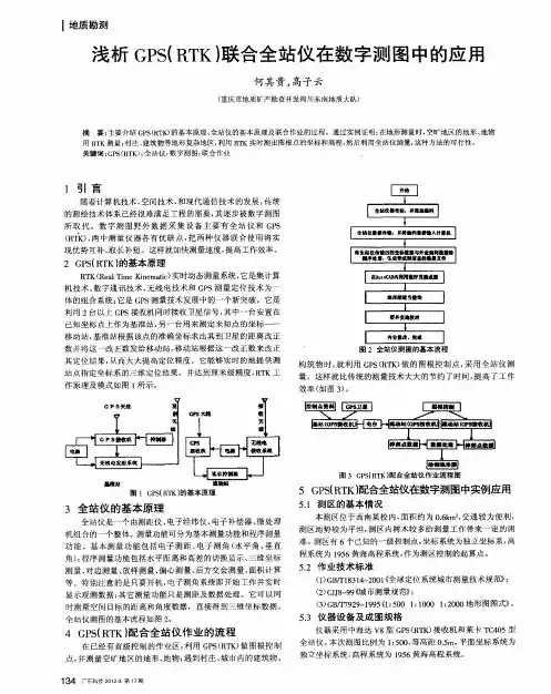
集全站仪和GPS(RTK)在数字测图中的应用数字测图是在测量工作中利用电子计算机技术将野外数据采集系统与内业机助制图系统相结合,其目标是实现采集处理的数字化、自动化、化。
数字测图可以缩短作业时间,减轻劳动强度,提高成果精度。
数字测图系统主要由数据输入、数据处理和数据输出3部分组成,数字测图作业模式中测记式数字测图应用最为广泛。
大比例尺数字测图正以其测图精度高,成图速度快等优势逐步的取代传统的,以平板仪为主的模拟测图。
与传统的模拟测图相比,数字测图的质量控制关键点更多、内容与方法更为复杂。
GPS新技术的出现,可以高精度并快速地测定各级控制点的坐标,在地形测量中已得到广泛地应用。
本文介绍了GPS配合全站仪其在地形测量中的应用。
在利用实测数据成图的过程中,解决一些常见的问题,并给出解决的办法及依据,同时给出一些有益的结论,以适应实际使用的需要。
1、GPS与全站仪联合数字测图的外业实施1.1作业技术依据《全球定位系统城市测量技术规程》;《城市测量规范》,《1∶500,1∶1000,1∶2000地形图图式》;GB/T7929—1995。
平面基准采用1954年北京坐标系;高程基准采用1956年黄海高程系。
1.2测区的基本情况:本测区位于温州市灵昆镇,交通较为便利,测区地势较为平坦,测区布设8个已知的四等GPS控制点,作为测区平面控制的起算点。
1.3控制测量1.3.1 控制测量分类地形测图控制测量是为测绘地形图而建立平面和高程控制网的测量工作,内容分为基本控制和图根控制。
基本控制是整个测区控制测量的基础。
图根控制是直接为地形测图服务的控制网。
基本控制网的建立要根据测区面积的大小,以满足当前需要为主,兼顾远景发展。
一般先建立控制全局的首级网,然后再根据需要加密,也可一次建立足够密度的全面网。
平面控制网可采用测角网、测边网或边角网,建成区多采用导线网。
在已建有国家或当地平面控制网点的测区内进行测量时,应与之进行联结。
GPS RTK全站仪联合在数字测图工程中的应用摘要:GPS RTK(实时动态GPS测量)技术能够实时地提供测站点厘米级的三维定位结果,速度快、精度高,但应用范围受自然条件限制。
全站仪是自动化程度很高的野外测量仪器,精度高、应用广,但受通视条件、测量距离等因素制约。
本文介绍了全站仪联合RTK测图的作业流程,简要阐明了其在地形测量中的应用。
在利用实测数据成图的过程中,解决一些常见的问题,并给出解决的办法及依据,同时给出一些有益的结论,以适应实际使用的需要。
关键词:RTK;全站仪;数字测图Abstract:GPSRTK technique can provide, in real time, 3 dimension positioning achievementofmeasuring station which the precision is centimeter leve,l itsmeasuring velocity is quick, precision high, but its' confined by the natura condition. Total station surveying is amature techniquewith high accurate and isusedwidely. But it is confined by sigh conditions, measuring distance, etc.The operation process of RTK electronic tachometer is introduced and its application in topographic survey is briefly illustrated. Solutions to some problems usually occur in the mapping process using actually measured data and some helpful conclusions are given for practical use.Key words:RTK; electronic tachometer; digital mapping第一章前言随着测绘科学技术的发展,传统的测图方法正逐步被不断涌现的新仪器、新设备、新技术、新方法所取代。
浅论全站仪的数字化技术在地形图测绘中的应用摘要:随着科学技术的不断快速发展,各种新型的数字化技术已经在地图测绘的工作过程之中发挥了重要的作用,而全站仪的数字化技术则是数字技术的重要一种。
针对这样的情况,本文将重点分析全站仪数字技术在地形图测绘之中的测设原理,尤其是全站仪数字化技术的的GPS的动态定位技术,详细的阐述全站仪的数字化技术的应用和开发存在的巨大的潜力。
并结合城市数字化地形图测绘具体的工程实际,介绍全站仪的数字化技术在地形图测绘中的具体应用手段。
通过本文,笔者希望能够起到一个抛砖引玉的作用。
关键词:全站仪;数字化技术;地形图测绘;应用;一、全站仪的数字化技术的优缺点所谓全站仪的数字化技术,顾名思义指的是利用一种可以直接测定地面点三维坐标,与此同时,还可以将测绘的数据进行自动存储的全站仪设备进行的数字化处理方式。
在地形图测绘的过程之中使用这种可以直接测定和存储地面点三维坐标数据的全站仪设备,可以获得比传统的测量方式更加优良的地理位置精确性,已经在地形图测绘领域之中得到了较为广泛的应用。
采用全站仪的数字化技术在地形图测绘之中进行测绘的优点有以下几个方面:首先,采用全站仪的数字化技术在地形图测绘之中进行测绘可以通过相对比较简单易行的操作方式完成对地形图的测绘,还可以在这个过程之中直接获取地形图的地面点三维坐标,提升地形图测绘的准确度;其次,采用全站仪的数字化技术在地形图测绘之中进行测绘可以尽可能的减少进行地形图测绘的工作人员的人员配备数量,在一般情况下,使用的三个专业的测绘人员就可以圆满的完成采用全站仪的数字化技术在地形图测绘之中进行测绘的任务,有着相对较高的测绘工作效率;然后,采用全站仪的数字化技术在地形图测绘之中进行测绘可以尽可能的全站仪仪器和CASS 等专业的地形图测绘软件进行匹配连接。
通过这样的方式,就可以很有效的将全站仪直接获取的地形图的地面点三维坐标直接传输坐标成地形图,极大的提升了地形图测绘的内部测量效率和成图效率;再次,采用全站仪的数字化技术在地形图测绘之中进行测绘可以和平差易等专业的控制测量软件配合使用,提升地形图测绘过程之中的测绘效率和测绘准确性;最后,采用全站仪的数字化技术在地形图测绘之中进行测绘可以尽可能的全站仪仪器和CASS 等专业的地形图测绘软件进行匹配连接,在这样的背景之下,一旦在地形图测绘过程之中出现一定的问题,可以通过全站仪和CASS 等专业的地形图测绘软件进行对出现的问题错误的及时调整,防止错误延续进行下去,保证地形图测绘的工作效率。
利用全站仪进行数字化测图利用全站仪进行数字化测图是测图比较普遍的方法,文章通过笔者积累的一些测图经验,阐述了全站仪数字化测图基本方法,并提出一些在测图中应注意的问题。
标签:数字化测图控制测量碎部测量1前言数字化地形图测量常用测图方法有:航测、RTK和全站仪进行测图。
航空摄影测量成图一般是大面积测图时使用,在工程建设中,测图的面积也只有几平方公里,如此小面积测图采用航测不划算,全站仪测图比RTK测图质量好,精度高,在工程建设中采用全站仪进行测图才是正确的选择。
下面对全站仪数字化测图基本方法进行阐述,并提出在测图中应注意的问题。
2测图方法全站仪数字化测图是采用全站仪结合自动记录设备外业采集数据,人工干预数字化软件和计算机辅助的内外业一体数字化成图。
在测图过程中主要采用绘草图法、编码法和草图与编码结合法进行测量。
2.1控制测量测图控制网布设,应充分利用测区及其周边已有控制资料,因地制宜,全面规划、满足测图精度要求,全面控制、分级布网,测图过程中适当加密。
根据实践经验,首级控制网一般采用静态GPS测量比较方便。
次级控制根据测图比例尺,以首级控制点作为起算点进行测设,在测图过程中用图根导线和图根点进行加密。
在高程控制测量中,大比例尺测图每个GPS控制点都应联测国家水准,联测国家水准的等级据工程需要和测图精度而定。
在小比例尺测图中,只要联测量水准的控制点分布均匀,部分GPS联测量水准高程,GPS拟合后高程也能达到测图精度的需要。
2.2碎部测量碎部测量数据采集一般采用极坐标法,采集遵循有顺序地对相关点进行连续采集的原则,尽量不要交叉采集不相关的点。
2.2.1碎部点采集密度碎部点采集密度应符合规范要求,在实际测量中地貌、地形比较平坦的地方,可减少碎部点采集的密度;地貌、地形比较复杂的地方,可增大碎部点采集密度,这样既能正确表示相应的地形特征,成图又美观,图形精度又高。
2.2.2测绘内容及综合取舍地形图主要表示测量控制点、居民地、工矿建筑物及其他设施、交通及附属设施、管线及附属设施、水系及附属设施、境界、地貌、植被等地物、地貌要素,及地理名称注记等。
目录摘要 (I)ABSTRACT (II)1绪论 (1)1.1课题选取的意义与背景 (1)1.2全站仪数字测图技术的发展现状 (1)1.3全站仪数字测图技术的未来发展期望 (1)2数字化测图技术概述 (2)2.1数字化测图技术的概念 (2)2.2数字化测图技术的基本原理 (2)2.3数字化测图系统的组成 (3)2.3.1地形数据采集系统 (3)2.3.2数据处理与成图系统 (3)2.3.3图形输出设备 (4)2.4数字测图的优势 (4)3全站仪数字测图系统 (6)3.1全站仪 (6)3.2全站仪的基本组成结构 (6)3.2.1光电测量系统 (7)3.2.2双轴液体补偿系统 (8)3.2.3自动瞄准与跟踪 (8)3.3全站仪数字测图系统的内业成图软件 (8)3.4全站仪数字测图技术的作业模式 (8)3.5全站仪使用的注意事项 (9)4以实际工作具体讲述全站仪在数字测图的应用 (11)4.1全站仪数字测图的前期准备工作 (11)4.1.1组织协调工作 (11)4.1.2收集测区的相关资料 (11)4.1.3对测区概况的实地踏勘 (12)4.1.4数字测图所需要的仪器及器材的准备 (12)4.1.5对测区进行控制测量方案设计 (12)4.1.6实习小组的人员的组织和安排 (12)4.2编写全站仪数字测图的技术设计书 (12)4.2.1编写技术设计书的意义 (12)4.2.2编写技术设计书的基本原则 (13)4.2.3数字测图技术设计书的内容 (13)4.3布设控制网 (13)4.4在布设好的控制网的基础上采集碎部点 (15)4.5全站仪数字测图的内业绘图要求 (16)4.6全站仪数字测图的成果检查与验收 (16)5全站仪数字测图技术中出现的问题 (16)5.1全站仪数字测图在外业测量中出现的问题 (16)5.2全站仪数字测图内业处理中出现的问题 (17)6利用全站仪进行数字测图技术的要点分析 (18)6.1平面地形图的测绘 (18)6.2平面房屋的数字测图 (18)6.3线杆的测量 (19)7全站仪数字测图的误差分析 (20)7.1仪器本身的误差 (20)7.2仪器的对中误差对水平角测量精度的影响 (20)结束语 (21)致谢 (22)参考文献 (23)全站仪在数字测图技术中应用摘要20世纪70年代起,随着光电测距和计算机技术在测绘领域的广泛应用,产生了全站型电子速测仪及计算机辅助制图系统,两者结合逐步形成一套从野外数据采集到内业成图,实现了全过程数字化的大比例尺地形测图方法,也就是所谓的野外数字测图技术,我们习惯简称为数字测图。
科学发展的今天,数字化测图技术在野外采集数据主要通过全站仪进行的,全站仪采集数据具有准确,容易,方便等特点。
野外通过全站仪准确迅速的采集数据,内业将数据传输到电脑上进行快速的内业成图。
数字化测图的成果有已于存储,传输方便,精度与比例尺无关,不存在变形及损耗,能方便,及时的进行局部的修测更新,便于保持地形图现势性的巨大优势。
本论文浅谈全站仪的使用方法和其在数字测图技术中碎部点的采集以及数据的误差分析等。
关键词全站仪/数字测图技术/外业测量/内业成图The Application Of Total StationIn Digital Mapping TechnologyABSTRACTIn the 1970 s, along with electro-optical distance measurement and computer technology is widely used in the field of surveying and mapping, the total station electronic measuring instrument and computer aided drawing system, a combination of gradually formed a set of field data collected from into a figure in the industry, realize the whole process of digital terrain map with large scale method, also known as field digital mapping technology, we used digital map for short. Scientific development today, the digital mapping technology in the field gathering data is mainly done by total station, total station to collect data is accurate, easy, convenient, etc. Field by total station is accurate, rapid acquisition data and to transmit data to the computer in the industry on the fast into a figure in the industry. The results of the digital mapping has been in storage, transport convenience, accuracy has nothing to do with scale, there is no deformation and loss, can be convenient, timely revision update locally, easy to maintain topographic map processing.along huge advantage. This paper discuss about the use of total station in digital mapping technology, method and its detail error of the point of acquisition, and data analysis.KEYWORDS Total Station,Digital Mapping Technology,Field Survey,Mapping In The Industry1绪论1.1 课题选取的意义与背景20世纪70年代起,随着越来越多的高科技在测绘领域中的应用,也伴随着许多高科技测绘仪器的出现。
例如全站仪和GPS双频动态接收机。
高科技测绘仪器的出现,伴随也就产生了相应的测图技术,其中,全站仪数字测图技术就是科技进步催生的现代化测图技术,熟练掌握全站仪测图技术是对当今每一个测绘工作者的基本要求,本篇论文就围绕全站仪在数字测图技术中的应用展开讨论,着重讨论全站仪数字测图技术的特点以及其工作模式,也对这种测图方法的误差进行了一点分析。
1.2 全站仪数字测图技术的发展现状在我国现在全站仪数字测图技术还是占主要地位,因为相比更加先进的GPS 测图,全站仪的成本低,且容易操作,为更多测绘工作者应用。
由于我们自主研发的北斗导航系统还没有正式成型,现在国内采用的基本都是美国的GPS双频动态接收机进行数字测图,由于美国对此技术的垄断,当然就导致其成本高,所以虽然利用GPS测量比全站仪更加方便,但考虑到其成本,全站仪以其低成本还是在数字测图技术中占据主导地位。
1.3 全站仪数字测图技术的未来发展期望全站仪数字测图技术优点众多,而且随着科技的进步,测量机器人的出现,可是使全站仪做到自动跟踪,瞄准测量,使得全站仪数字测图的工作更加轻松。
随着我国的北斗导航的逐步成型,全站仪的角色可能会变得少一点,但是其作用不能被替代,毕竟其对工作环境要求低,且成本低,还是会被广大测量工作者采用,尤其全站仪正向测量机器人的方向前进,这会使未来的测绘工作变得轻松,而数字地形图的采集也会更加迅速。
由于全站仪的技术已经被越来越多的国内生产企业所掌握,全站仪的价格也会越来越低,可能最终会彻底淘汰经纬仪,全站仪在数字测图技术中的作用会越来越重要。
2 数字化测图技术概述2.1 数字化测图技术的概念地形测量是指测量地球表面局部区域的各种地形、地物在确定参照系统中的位置和几何形状,以一定的比例尺缩小,并按特定的的符号绘制成平面图形的工作。
传统的大比例尺地形测量是测量地形、地物特征点到测站的距离及其相对某一参考方向的角度,使用量角器、比例尺的绘图工具,直接在绘图纸上定点,并按规定的符号手工绘制地形图。
这种测图方法,因为直接在绘图纸上定点绘图,因此又成为白纸测图或模拟法测图。
但此种测图方法因为其劳动强度大,作业效率低,并且由于读书、记数、量角、距离换算、展点、绘图等众多环节出错几率大,使得地形成果质量难以保证。
因此从20世纪70年代起,随着光电测距和计算机技术在测绘领域的广泛应用,产生了全站型电子速测仪及计算机辅助制图系统,两者结合逐步形成一套从野外数据采集到内业制图,实现了全过程数字化的大比例尺地形测图方法,及称为所谓的野外数字测图技术,我们习惯简称为数字化测图。
[1]2.2 数字化测图技术的基本原理数字化测图的基本原理是采集地面上的地形、地物要素的三维坐标以及描述其性质与相关关系的信息,然后录入计算机绘图系统处理,显示、输出与传统地形图表现形式相同的地形图。
其中,我们习惯将地形、地物要素转换为数字信息这一过程称为数据采集。
计算机绘图系统是用用专业的数字化地形图编辑成图软件,通过人机交互的方式编辑地形图,或录入计算机能识别的信息,自动将野外采集的数据绘制成地形图。
由于计算机软件通过计算、展点、识别、连接、加注记符号等步骤处理采集的数据,绘出所测的地形图过程,通常是在数据采集后进行的,要使计算机软件能识别所采集的数据,并据此绘制出传统意义上的地形图,野外测绘时除点位的三维坐标外,还必须采集点位的连接信息和描述其性质的属性信息。
[2]点位的三维坐标亦称点位信息,使用数字化测绘设备采集并自动计算存储在设备内存或电子手簿中,各个点之间以点号区别,连接信息是指测点的关联关系,它包括相邻连接点号和连接线型,绘图系统据此方可将相关的点连接成一个地形、地物符号,点位信息和连接信息合成为图形信息,又称为几何信息,据此可以绘制房屋、道路、河流、地类界、等高线、陡坎等地形图元素。
[3]2.3 数字化测图系统的组成数字化测图系统是以计算机为核心,在外连输入、输出设备硬件和软件的支持下,对空间数据及相关属性信息进行采集、输入、处理、绘图、输出、管理的测绘系统。