面向对象的高分辨率遥感影像分类
- 格式:pdf
- 大小:2.41 MB
- 文档页数:37
1.几何校正:几何校正是利用地面控制点和几何校正数学模型来矫正非系统因素产生的误差,同时也是将图像投影到平面上,使其符合地图投影系统的过程。
2.图像镶嵌:指在一定的数学基础控制下,把多景相邻遥感影像拼接成一个大范围、无缝的图像的过程。
3.图像裁剪:图像裁剪的目的是将研究之外的区域去除。
常用方法是按照行政区划边界或自然区划边界进行图像裁剪。
在基础数据生产中,还经常要进行标准分幅裁剪。
按照ENVI 的图像裁剪过程,可分为规则裁剪和不规则裁剪。
4.图像分类:遥感图像分类也称为遥感图像计算机信息提取技术,是通过模式识别理论,分析图像中反映同类地物的光谱、空间相似性和异类地物的差异,进而将遥感图像自动分成若干地物类别。
5.正射校正:正射校正是对图像空间和几何畸变进行校正生成多中心投影平面正射图像的处理过程。
6.面向对象图像分类技术:是集合邻近像元为对象用来识别感兴趣的光谱要素,充分利用高分辨率的全色和多光谱数据的空间、纹理和光谱信息来分割和分类,以高精度的分类结果或者矢量输出。
7.DEM:数字高程模型是用一组有序数值阵列形式表示地面高程的一种实体地面模型。
8.立体像对:从两个不同位置对同一地区所摄取的一对相片。
9.遥感动态监测:从不同时间或在不同条件获取同一地区的遥感图像中,识别和量化地表变化的类型、空间分布情况和变化量,这一过程就是遥感动态监测过程。
10.高光谱分辨率遥感:是用很窄而连续的波谱通道对地物持续遥感成像的技术。
在可见光到短波红外波段,其波谱分辨率高达纳米数量级,通常具有波段多的特点,波谱通道多达数十甚至数百个,而且各波谱通道间往往是连续的,因此高光谱遥感又通常被称为"成像波谱遥感"。
11.端元波谱:端元波谱作为高光谱分类、地物识别和混合像元分解等过程中的参考波谱,与监督分类中的分类样本具有类似的作用,直接影响波谱识别与混合像元分解结果的精度。
12.可视域分析:可视域分析工具利用DEM数据,可以从一个或多个观察源来确定可见的地表范围,观测源可以是一个单点,线或多边形13.三维可视化:ENVI的三维可视化功能可以将DEM数据以网格结构、规则格网或点的形式显示出来或者将一幅图像叠加到DEM数据上。
高分一号-卫星遥感影像面向对象的水边线提取摘要:本文通过采用高分一号卫星的遥感影像,结合面向对象的方法实现水边线的提取。
通过对高分一号卫星遥感影像的数据处理,生成具有高精度的数字卫星图像,并利用面向对象的方法,基于多特征融合的思想,对水边线进行提取,并与现场调查结果进行对比,结果表明本文提取出的水边线与现场调查结果相近,具有较高的提取准确度。
关键词:高分一号,遥感影像,面向对象,水边线提取,多特征融合,提取准确度Introduction:随着卫星技术的不断发展,卫星遥感技术已经成为了地球环境变化研究的有力工具。
水边线是很多地理信息系统应用中一个重要的参数,例如水资源管理、海岸线资料的获取等。
本文基于高分一号卫星遥感影像,采用面向对象的方法实现水边线的提取。
Methodology:本文采用高分一号卫星遥感影像,对其进行预处理、增强,利用面向对象的方法提取水边线。
面向对象的方法能够对地物进行更加精细的识别和分类,进而提高水边线提取的准确率。
同时,为了增加提取准确率,本文采用多特征融合的思想,将多种特征结合在一起进行水边线提取。
具体步骤如下:1. 预处理:将高分一号卫星遥感影像进行预处理,包括图像平滑、噪声去除等。
2. 增强处理:对预处理后的图像进行增强处理,增强水边线的对比度和边缘信息。
3. 物体分割:采用基于颜色和纹理的物体分割算法,对水域及其周围的其他物体进行分割。
4. 特征提取:对分割后的物体进行特征提取,包括:颜色、纹理、形状、边缘等。
5. 特征融合:采用多特征融合的思想,将多种特征结合在一起进行水边线提取。
6. 水边线提取:基于提取出来的特征,采用基于几何形状的水边线提取算法,提取出水边线。
Results:将本文提取的水边线与现场调查结果进行对比,结果表明本文提取出的水边线与现场调查结果相近。
同时,本文采用准确度和混淆矩阵对提取结果进行评估,证明了本文的提取方法具有较高的准确度和可靠性。
Conclusion:通过对高分一号卫星遥感影像的处理和分析,本文采用面向对象的方法,结合多特征融合的思想,实现了对水边线的提取。
基于高分辨率影像土地利用遥感动态监测与分类信息提取方法摘要:本文介绍了基于高分辨率影像的土地利用遥感动态监测与分类信息提取方法,利用遥感技术动态监测土地利用的本质是对图像系列时域效果进行量化,通过量化多时相遥感图像空间域、时间域、光谱域的耦合特征,来获得土地利用变化的类型、位置和数量等内容。
利用遥感技术可以快速、大范围的获得土地利用变化区域,例如建设用地、农业用地、工业用地、交通用地,水体(河道变化)等。
关键字:遥感技术土地利用影像分类动态监测图像分割1.背景随着社会经济的发展,特别是城市建设步伐的加速,城市土地利用每年都在发生明显的变化。
传统的土地利用调查需要花费大量的人力、时间和经费,难以适应土地利用的这种快速变化。
遥感以其覆盖面大、信息更新快、人为干扰因素小等优点已逐渐应用到土地利用变化遥感动态监测中。
我国遥感技术在土地资源调查和监测中的应用始于20 世纪90 年代。
国家土地管理局成立以后,在国务院统一布署下,利用了TM、SPOT等多种遥感数据源,进行目视解译、分析和计算机自动分类制图等组织完成了全国县级土地详查,这一成果为各级政府制定经济建设规划、计划,为农业、工业、水利、能源、交通等各专业部门制定规划、计划提供了可靠的数据资料、为各项土地管理工作提供准确依据,已在经济建设、农业生产和土地管理中发挥了重要作用,也为我国开展土地利用动态监测提供了完整、可靠的本底资料。
1.技术流程和关键技术1.技术流程土地利用变化遥感动态监测是一个工作量比较大的过程,对遥感数据的预处理要求较高,变化信息的发现和变化信息的提取可选择和组合的方法很多,技术含量较高。
下图为土地利用变化遥感动态监测的技术流程。
1.动态监测技术流程1.关键技术遥感动态监测主要涉及图像预处理和土地利用变化信息检测和提取两部分,其关键技术也就主要包括图像预处理方法和土地利用变化信息提取方法。
值得我们注意的是,变化检测方法和信息提取方法不能说哪个绝对的好与坏,只能是根据不同的数据源和不同的应用需求选用适合的方法。
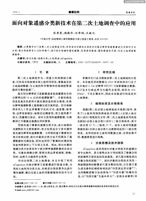
四川建筑 第卷期 1高分辨率卫星影像计算机分类方法的比较桑明智(西南交通大学,四川成都610031) 【摘 要】 从研究应用需求上阐明不同分辨率的特征,从而依据不同分辨率下影像的特征阐述不同的分类方法,结合绵阳地区快鸟高分辨率卫星影像数据,用不同的分类方法进行分类,并对比总结,最后得出高分辨率影像分类的关键方法。
研究目的是就同一地区的高分辨率卫星图象,用面向对象软件eCog nition 和传统的基于像素的分类软件分别进行分类,从实践上去验证面向对象分类软件eCogniti on 是十分适合高空间分辨率、纹理信息丰富的图象的,也是解决高分辨率数据利用不充分问题的关键所在。
【关键词】 高分辨率; 卫星影像; 分类方法 【中图分类号】 P236 【文献标识码】 A 高分辨率卫星影像指的是遥感图像的空间分辨率在10m 以内的遥感影像。
对于遥感图像而言,分辨率有四种:空间分辨率、时间分辨率、光谱分辨率、辐射分辨率。
但分辨率也遵循“鱼与熊掌不可兼得”的道理,比如对于空间分辨率和辐射分辨率而言,他们之间就必须依据遥感应用的目的进行取舍,当空间分辨率对于研究需要更重要时,就不得不舍弃辐射分辨率。
所以,虽然高分辨率影像数据具有丰富的空间信息,且地物几何结构和纹理信息更加明显,更便于认识地物目标的属性特征,但通常却包含较少波段,光谱特征不如空间特征丰富。
然而,传统的遥感图像分类方法,比如,监督分类和非监督分类,都是以图像的灰度为基础的。
也就是说,是依据地物在图像上的光谱信息特征而进行的。
因为,同类的地物在图像上对应像元的特征向量将集中在同一特征空间区域;反之,不同的地物光谱信息特征所表达的空间信息特征则不同。
所以,对于高分辨率影像而言,这种侧重于多光谱分辨率的遥感影像分类方法是不适合的。
传统分类方法将会造成高分辨率图像的分类精度降低、空间数据冗余度大等问题,从而造成资源的浪费。
对于高分辨率的图像进行分类,应该根据其图像本身所具有的最显著的特征———丰富的空间信息、明显的地物几何结构和纹理信息———进行分类。
面向对象的遥感影像信息提取摘要:随着遥感技术的不断发展,遥感影像的分辨率不断的提高,如何对遥感影像中的地物信息进行高效、快速的提取,是当前研究的热点问题。
面向对象的方法先对影像进行多尺度分割得到同质区域对象,充分利用遥感影像中丰富的光谱、形状、纹理等特征对分割后的对象进行分类。
面向对象的遥感信息提取的方法克服了传统的基于像元的分类方法只依靠光谱信息的缺点,更高效的获取地物信息,得到更高精度的分类结果。
关键词:多尺度分割、分类、遥感影像、面向对象Abstract:With the continuous development of remote sensing technology, the resolution of remote sensing image is constantly improving. How to efficiently and quickly extract the ground object information in remote sensing image is a hot issue in current research. The object oriented method firstly segmented the image to obtain the homogeneous region object, and made full use of the rich spectral, shape, texture and other features of remote sensing image to classify the segmented object. The object-oriented remote sensing information extraction method overcomes the shortcoming of the traditional classification method based on pixel which only relies on spectral information, and obtains the ground object information moreefficiently and gets the classification result with higher precision.Key word:Multi-scale segmentation、classification、remote sensing image、object oriented.1引言利用面向对象的信息提取技术,可以更好掌握实际生产生活中地物变化情况,以及土地利用等情况,能够为国土空间规划、土地利用调查、资源普查、交通规划、生态旅游发展等工作提供有力的数据支撑。
第38卷第3期2015年3月测绘与空间地理信息GEOMATICS&SPATIALINFORMATIONTECHNOLOGYVol.38,No.3Mar.,2015收稿日期:2014-09-03,修订日期:2015-01-12基金项目:国家自然科学基金(51213811)资助作者简介:孔令婷(1991-),女,江苏南京人,摄影测量与遥感专业硕士研究生,主要研究方向为遥感图像处理与应用。
基于不同分辨率遥感影像的分类方法对比研究孔令婷,杨英宝,章 勇(河海大学地球科学与工程学院,江苏南京210098)摘要:基于4种不同分辨率的遥感影像数据,分别为30m分辨率的Landsat-8数据,融合Landsat-8多光谱波段和全色波段的15m分辨率数据,5.8m分辨率的资源3号卫星数据以及融合后2.1m分辨率的资源3号卫星数据。
采用ISO-DATA、最大似然分类法和面向对象分类法对影像进行分类,对分类方法的效果以及分辨率变化对面向对象分类方法的精度影响进行分析。
结果显示在低分辨率影像中,面向对象方法受到限制,分类效果相比传统方法没有太大改善;而在高分辨率影像中,面向对象方法分类效果很好,并且随着分辨率提高分类精度也相应的提高。
关键词:高分辨率影像;分类;面向对象中图分类号:P237 文献标识码:A 文章编号:1672-5867(2015)03-0040-04StudyonClassificationMethodsBasedonDifferentResolutionRemoteSensingImageKONGLing-ting,YANGYing-bao,ZHANGYong(SchoolofEarthScienceandEngineering,HohaiUniversity,Nanjing210098,China)Abstract:Thispaperisbasedonfourdifferentresolutionsremote-sensingimages.30mresolutionLandsat-8imagedata,15mresolutionimagefusedbymultispectralbandsandpanchromaticbandoflandsat-8data,5.8mresolutionZY-3imagedataand15mresolutionfusionimage.ISO-DATA,maximumlikelihoodclassificationandobject-orientedimageclassificationmethodwereused.Theeffectsofdifferentclassificationmethodsandimpactofresolutionchangesontheaccuracyofobject-orientedmethodwereanalyzed.Theresultsshowthatobject-orientedapproachislimitedinlowresolutionimages,theclassificationresultisnotmuchim-provedcomparedtothetraditionalclassificationmethod.Whileinthehigh-resolutionimagestheobject-orientedclassificationmethodworkswell,andclassificationaccuracyisimprovedalongwithresolutionincrease.Keywords:high-resolutionimages;classification;object-oriented0 引 言在传统的遥感影像分类中,基于像元的分类较多,包括监督和非监督分类法。
遥感图像分类方法的国内外研究现状与发展趋势关键词:遥感图像、发展、分类、计算机一、遥感技术的发展现状遥感技术正在进入一个能够快速准确地提供多种对地观测海量数据及应用研究的新阶段,它在近一二十年内得到了飞速发展,目前又将达到一个新的高潮。
这种发展主要表现在以下4个方面:1.多分辨率多遥感平台并存。
空间分辨率、时间分辨率及光谱分辨率普遍提高目前,国际上已拥有十几种不同用途的地球观测卫星系统,并拥有全色0.8~5m、多光谱3.3~30m的多种空间分辨率。
遥感平台和传感器已从过去的单一型向多样化发展,并能在不同平台上获得不同空间分辨率、时间分辨率和光谱分辨率的遥感影像。
民用遥感影像的空间分辨率达到米级,光谱分辨率达到纳米级,波段数已增加到数十甚至数百个,重复周期达到几天甚至十几个小时。
例如,美国的商业卫星ORBVIEW可获取lm空间分辨率的图像,通过任意方向旋转可获得同轨和异轨的高分辨率立体图像;美国EOS卫星上的MOiDIS-N传感器具有35个波段;美国NOAA的一颗卫星每天可对地面同一地区进行两次观测。
随着遥感应用领域对高分辨率遥感数据需求的增加及高新技术自身不断的发展,各类遥感分辨率的提高成为普遍发展趋势。
2.微波遥感、高光谱遥感迅速发展微波遥感技术是近十几年发展起来的具有良好应用前景的主动式探测方法。
微波具有穿透性强、不受天气影响的特性,可全天时、全天候工作。
微波遥感采用多极化、多波段及多工作模式,形成多级分辨率影像序列,以提供从粗到细的对地观测数据源。
成像雷达、激光雷达等的发展,越来越引起人们的关注。
例如,美国实施的航天飞机雷达地形测绘计划即采用雷达干涉测量技术,在一架航天飞机上安装了两个雷达天线,对同一地区一次获取两幅图像,然后通过影像精匹配、相位差解算、高程计算等步骤得到被观测地区的高程数据。
高光谱遥感的出现和发展是遥感技术的一场革命。
它使本来在宽波段遥感中不可探测的物质,在高光谱遥感中能被探测。
第三次国土调查中面向对象的自动分类技术运用分析第三次国土调查是国家对全国土地资源、利用状况进行全面调查的一项重要工作。
在第三次国土调查中,面向对象的自动分类技术成为了一项重要的工具。
本文将对该技术在国土调查中的运用进行分析和讨论。
我们来了解一下面向对象的自动分类技术。
面向对象的自动分类技术是一种基于遥感影像的地物识别和分类技术,它可以自动识别和分类地表覆盖的各类目标,如建筑物、道路、植被等。
这种技术具有高效、准确、规模化的特点,可以大大提高土地资源调查的效率和精度,因此在国土调查中得到了广泛的应用。
在第三次国土调查中,面向对象的自动分类技术被广泛应用于土地利用、土地覆盖、城乡建设用地等方面。
通过对高分辨率遥感影像的处理和分析,可以实现对各类地物的自动识别和分类,从而获取大规模、实时、精准的土地利用状况、土地覆盖类型等信息。
这些信息对于国土资源的合理利用、土地规划、生态环境保护等方面具有重要的指导意义。
我们将具体分析面向对象的自动分类技术在国土调查中的运用。
首先是土地利用调查。
利用这项技术,可以对土地利用的类型、分布、变化情况进行精准的识别和分析,为土地管理、开发利用、生态环境保护等提供科学依据。
其次是土地覆盖调查。
通过遥感影像的分析和处理,可以实现对地表覆盖类型的自动识别和分类,获得大范围、多时相的土地覆盖信息,为土地资源评价、监测、管理提供支持。
再次是城乡建设用地调查。
利用面向对象的自动分类技术,可以实现对城乡建设用地的分布、变化、利用效率等方面的快速、准确的识别和分析,为城乡规划、土地管理、城乡一体化发展提供科学依据。
最后是生态环境调查。
通过对植被覆盖、水体分布、土地退化等方面的分析,可以实现对生态环境状况的全面评价和监测,为生态保护、修复、可持续发展提供数据支持。
我们将展望面向对象的自动分类技术在未来国土调查中的发展方向。
首先是提高算法准确度和稳定性。
通过改进算法设计和参数调整,提高面向对象的自动分类技术对遥感数据的适应性和准确度,实现更加精准的地物识别和分类。
二○一一届毕业设计面向对象的高分辨率遥感影像分类Object-orientedClassificationofhighResolutionRemoteSensingimages
学院:地质工程与测绘学院专业:遥感科学与技术姓名:学号:指导教师:完成时间:2011年6月17日
二〇一一年七月摘要高空间分辨率遥感影像使得在较小的空间尺度上观察地表细节变化,进行大比例尺遥感制图,以及监测人为活动对环境的影响成为可能。随着高分辨率影像的应用越来越普及,迫切要求人们对高分辨率遥感信息提取进行研究,以满足高分辨率影像信息不断增长的应用和研究需要高分辨率遥感影像光谱信息有限,空间信息丰富,地物的尺寸、形状及相邻地物间的关系都得到很好的反映。面向对象的分类方法与传统的基于像素的分类相比,不仅仅是依靠光谱信息,而且还充分利用影像的空间信息,分类时也克服了基于像元的逐点分类无法对相同语义特征的像素集合进行识别的缺点,是一种目前最适合于高分辨率遥感影像的分类方法。本文采用面向对象的分类方法对高分辨率影像进行分类,该方法首先对影像进行多尺度分割获得同质区域对象,在此基础上利用模糊分类思想对分割后的对象进行分类。该方法不仅充分利用了高分辨率影像的空间信息,还将基于像素的分类提升到了基于对象的分类。多尺度分割采用的是区域生长合并算法,通过对尺度阈值、光谱因子及形状因子等参数的控制,可以获得不同尺度下有意义的对象。分割后的对象不仅包含了原始的光谱信息,还可以提供大量辅助特征,如纹理、形状、拓扑等特征。综合利用这些特征以及模糊分类的思想,使得高分辨率影像分类在减少分类不确定性的同时,还提高了分类的精度。最后将面向对象分类结果与传统的基于像素分类结果进行对比分析,发现其分类精度要明显高于传统法,且具有较强的抗噪声的功能,分类所得的地物结果相对较为完整,具有更丰富的语义信息,更加符合客观现实情形。
关键词:高分辨率遥感影像,面向对象的分类,影像分割,多尺度,最近邻分类AbstractWiththeapplicationofthehigh-resolutionimagemoreandmorepopular,itisurgentlyrequirepeopletocarryonresearchtoclassificationofthehigh-resolutionremotesensinginordertomeettheincreasingapplicationandstudyrequirementoftheinformationofhigh-resolutionimages.However,weusethetraditionalpixel-orientedmethodtoclassifythehigh-resolutionremotesensingimage,itcan’tfullyutilizeimageinformationweshouldreducetheprecisionofclassificationandhasslowspeed.Accordingtothecharacteristicofthehigh-resolutionremotesensingimage,thepaperproposestousetheobject-orientedmethodtoclassifyhigh-resolutionremotelysenseddata.Thispapermakesuseoftheobject-orientedapproachtotheclassificationofhigh-resolutionimagery,involvesthesegmentationofimagedataintoobjectsatmultiplescalelevels.Classrulesaregeneratedusingspectralsignatures,shapeandcontextualrelationships,andthenusedasabasisforthefuzzyclassificationoftheimagery.Theobjectisderivedbymeansofmulti-scalesegmentationinthispaper.Thehierarchicalimagesegmentationandregion-mergingareimplemented.Asidefromthespectralvaluesofthepixels,theshapeoftheobjectscreatedbythepixelsandtherelationshipsbetweentheobjects,arealsoconsideredduringtheclassification.Theutilizationofspectral,textural,shapepropertiesandfuzzythinkingmayreducetheuncertaintyintheprocessofclassification.Acomparisonoftheresultsshowsbetteroverallaccuracyoftheobject-orientedclassificationoverthepixel-basedclassification.Thisconclusionindicatesthatobject-orientedanalysishasgreatpotentialforextractinglandcoverinformationfromsatelliteimagery.KeyWords:high-resolutionimagery;object-orientedclassification;imagesegmentation;multi-scale;nearestneighbourclassification目录摘要................................................................................................................................2Abstract..........................................................................................................................3目录................................................................................................................................4第一章绪论..............................................................................................................51.1研究背景..........................................................................................................51.2面向对象的遥感影像分类方法的提出..........................................................61.2.1基于像元的分类方法...........................................................................61.2.2面向对象遥感影像分类方法的提出...................................................81.3面向对象遥感影像分类国内外研究现状......................................................81.3.1国际上面向对象遥感影像分类方法研究...........................................81.3.2国内面向对象遥感影像分类方法研究.............................................101.4研究方法和内容............................................................................................10第二章面向对象的遥感影像分类..........................................................................112.1影像分割........................................................................................................112.1.1多尺度影像分割.................................................................................12多尺度分割参数的选择..............................................................................122.2影像分类........................................................................................................172.2.1最邻近分类.........................................................................................172.2.2决策支持的模糊分类.........................................................................18第三章实验数据与研究方法..................................................................................193.1实验数据........................................................................................................213.2软件平台........................................................................................................213.3实验区信息提取实验....................................................................................223.3.1图像分割.............................................................................................223.3.2影像分类.............................................................................................263.3.3基于像元的影像分类.................................................................................31第四章分类结果评价............................................................................................324.1两种分类结果精度评价................................................................................32第五章结论与讨论................................................................................................345.1结论................................................................................................................345.2讨论................................................................................................................35参考文献......................................................................................................................36