英语国家概况之爱尔兰..
- 格式:ppt
- 大小:1.95 MB
- 文档页数:18
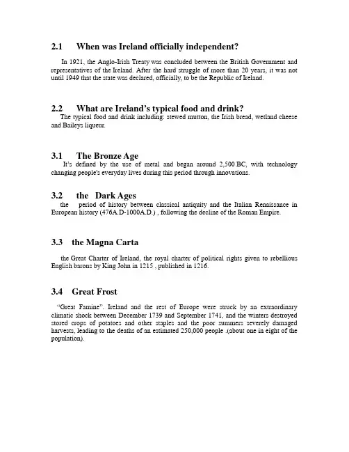
2.1 When was Ireland officially independent?In 1921, the Anglo-Irish Treaty was concluded between the British Government and representatives of the Ireland. After the hard struggle of more than 20 years, it was not until 1949 that the state was declared, officially, to be the Republic of Ireland.2.2 What are Ireland’s typical food and drink?The typical food and drink including: stewed mutton, the Irish bread, wetland cheese and Baileys liqueur.3.1 The Bronze AgeIt’s defined by the use of metal and began around 2,500 BC, with technology changing people's everyday lives during this period through innovations.3.2 the Dark Agesthe period of history between classical antiquity and the Italian Renaissance in European history (476A.D-1000A.D.) , following the decline of the Roman Empire. 3.3 the Magna Cartathe Great Charter of Ireland, the royal charter of political rights given to rebellious English barons by King John in 1215 , published in 1216.3.4 Great Frost“Great Famine”. Ireland and the rest of Europe were struck by an extraordinary climatic shock between December 1739 and September 1741, and the winters destroyed stored crops of potatoes and other staples and the poor summers severely damaged harvests, leading to the deaths of an estimated 250,000 people .(about one in eight of the population).。
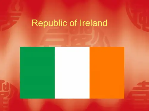
第十一章Part Two The Republic of Ireland爱尔兰共和国地理与历史 Geography and History不列颠群岛由两大岛屿和几百座小岛组成。
两大岛屿是大不列颠和爱尔兰岛。
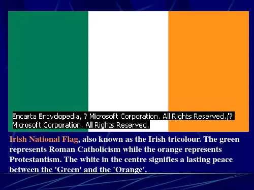
爱尔兰也因其乡村绿荫而被称为绿宝石岛。
爱尔兰分为两个政治区域:北爱尔兰和爱尔兰共和国。
北爱尔兰是联合王国的一部分。
爱尔兰共和国是个独立国家。
The British Isles are made up of two large islands and hundreds of small ones. The two large islands are Great Britain and Ireland. Ireland is also called the Emerald Isle because ot its rich green countryside. Ireland is divided into two political units. They are Northern Ireland and the Republic of Ireland. Northern Island is part of the United Kingdom. The Republic of Ireland (Eire) is an independent country.I.Geographical Features地理特征爱尔兰共和国的面积为70,282平方公里。
与北爱尔兰接壤的边界为434公里。
The Republic of Ireland covers an area of 70,282 sq.its land border with Northern Ireland is 434 km.首都是都柏林,The capital is Dublin.爱尔兰一直被比作盆地,内有海滨高地围起的石灰岩高原。
海洋性气候影响全国。
![Ireland[原创]英语国家概况.爱尔兰](https://uimg.taocdn.com/937bd06e5727a5e9856a618c.webp)
Chapter 12 Ireland TodayI. Political Structure 政治体制Ireland is a parliamentary republic and a unitary统一的s tate under the 1937 Constitution. The Constitution is theoretically 理论上applicable适用于to the whole of Ireland. Citizens of Northern Ireland are also considered citizens and can run for office 竞选in the South. The Republic of Ireland consists of 26 of the 32 counties of Ireland.根据1937年的宪法,爱尔兰是议会制共和国是中央集权国家。
理论上讲,此宪法适用于整个爱尔兰岛,北爱尔兰公民也被视为共和国公民,能够竞选南方的职位。
爱尔兰共和国由爱尔兰岛的32个郡中的26个郡组成。
1. Executive power 行政权suffrage 直接投票任期七年He sommons or dissolves the Oireachtas议会(Parliament); signs and promulgate s 颁布laws; appoints judges, the prime minister and other members of the cabinet;内阁and heads the defence forces.武装部队In addition, he has the right to refer提交certain bills to the Supreme Court for a decision on their constitutionality符合宪法and refer certain bills to the people by referendum. 全民公决The president is advised and assisted in his duties by the Council of State.国家委员会他召集或解散议会;签署和颁布法律;任命法官、首相和其他内阁成员;统率武装部队。

爱尔兰马铃薯饥荒爱尔兰曾经孕育了古凯尔特文明。
罗马帝国灭亡后,爱尔兰教会甚至一度能够和正统的罗马教会分庭抗礼( “圣诞树”这个习俗实际上就是来自于凯尔特教会)。
从16-17世纪开始,英格兰的诸个王朝就开始征服爱尔兰。
资产阶级革命后,克伦威尔派兵镇压爱尔兰人起义,大量屠杀信仰天主教的当地居民。
1801年,爱尔兰正式并入了联合王国的一部分。
在英国统治下,一方面爱尔兰始终没有如英格兰那样发展起工业;另一方面,随着大量移民的涌入,人口激增和土地兼并成为主要的问题。
大部分地主都居住在英格兰,高达人口8成的小农大部分是天主教徒。
他们为了养活自己,不得不大量种植土豆,导致爱尔兰的农作物高度单一。
这些都为后来的大饥荒埋下了伏笔。
从1845年开始,一种名为“晚疫病”的瘟疫席卷了爱尔兰,导致了大部分土豆腐烂。
7年间,爱尔兰人口减少了1/4,逃亡海外者高达100万人。
这场空前的饥荒于是又被称为“马铃薯饥荒”(Irish Potato Famine)。
这场灾难对爱尔兰的影响实在过于深远,以至于爱尔兰史的研究都被分成“饥荒前”和“饥荒后”两个时段。
印欧语系(Indo-European family),世界上分布区域最广的语系,使用者几乎遍及整个欧洲、美洲、澳洲,还有亚洲和非洲的部分地区。
印欧语系包括约443种(SIL统计)语言和方言。
而以某一种印欧语言为自己母语的人,加起来有15亿以上。
伦敦当地下层阶级的口音是非常土的,比较有名的是东伦敦地区的Cockney口音,也就是《两杆大烟枪》里面经常出现的(口音最重的是那父子俩)。
一般来说受到教育的人不会说这种口音。
他们说的是比较纯正的Received Pronunciation,比如托尼·布莱尔在国会发表演讲时的口音,又比如BBC的播音员的口音。
但是随着时代发展,这种观点也在受到非常强的挑战。
因为Cockney口音在影视作品中的经常出现,尤其是在动作片当中表现人物的硬朗,这种口音逐渐被英语国家的人熟悉,甚至有的时候受到相当的追捧,几乎到了凡是动作片都用Cockney的地步。