马来西亚[24页]
- 格式:pptx
- 大小:824.30 KB
- 文档页数:20


日期:CATALOGUE目录•马来西亚的地理位置和历史背景•马来西亚的文化特色•马来西亚的经济发展•马来西亚的旅游资源•马来西亚的社会生活与教育体系•总结与展望马来西亚的地理位置和历史背景地理位置区域划分地理位置及区域划分历史沿革及重要事件01020304早期历史殖民时代独立运动马来西亚成立外交关系经贸合作人文交流030201与中国的外交关系及合作马来西亚的文化特色伊斯兰教影响伊斯兰教是马来西亚的官方宗教,对马来西亚的文化和社会生活产生深远影响。
多元种族与信仰马来西亚是一个多元种族和多元宗教的国家,其中马来人、华人和印度人是三大主要种族。
各种族间的和谐共处是马来西亚文化的重要特征。
宗教自由与尊重宪法保障宗教自由,各种宗教信仰在马来西亚得到尊重和保护。
多元文化及宗教信仰官方语言汉语(包括粤语、普通话等方言)和泰米尔语在马来西亚也有大量使用者,是这多元文化国家的重要组成部分。
汉语与泰米尔语文学传统语言及文学音乐与乐器舞蹈表演传统艺术艺术、音乐与舞蹈马来西亚的经济发展高速发展人均收入较高经济结构转型经济发展现状及特点03农业基础稳固01服务业为主导02制造业重要组成主要产业及经济结构开放型经济政策税收优惠措施完善的法律保障贸易投资环境及政策马来西亚的旅游资源1 2 3吉隆坡槟城亚庇热门旅游城市景点推荐椰浆饭椰浆饭是马来西亚的国菜之一,用椰浆烹制的米饭搭配各种香料、肉类和蔬菜,口感丰富。
海南鸡饭海南鸡饭是马来西亚华人的传统美食,选用嫩滑的鸡肉搭配香浓的米饭,味道鲜美。
炒粿条炒粿条是马来西亚一道受欢迎的小吃,用粿条搭配蔬菜、海鲜或肉类炒制而成,口感爽滑。
美食文化体验特色旅游活动及购物攻略浮潜01热带雨林探险02购物攻略03马来西亚的社会生活与教育体系社会生活、民俗与禁忌社会生活禁忌政府重视教育公平,实施免费的基础教育,并提供各种奖学金和助学金,以确保所有阶层的学生都能接受良好的教育。
教育体系及政策教育政策教育体系知名大学马来西亚拥有一些世界知名的大学,如马来亚大学(University of Malaya)、马来西亚国立大学(Universiti Kebangsaan Malaysia)等。


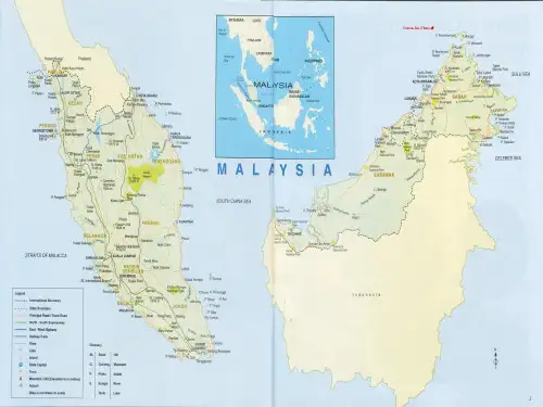
马来西亚地质及矿产资源馬來西亞面積330257平方公里。
马来西亚面积330257平方公里。
國土被南中國海分隔成東、西兩部分。
国土被南中国海分隔成东、西两部分。
西馬位於馬來半島南部,北與泰國接壤,南與新加坡隔柔佛海峽相望,東臨南中國海,西瀕馬六甲海峽。
西马位于马来半岛南部,北与泰国接壤,南与新加坡隔柔佛海峡相望,东临南中国海,西濒马六甲海峡。
東馬位於加裏曼丹島北部,與印尼、菲律賓、汶萊相鄰。
东马位于加里曼丹岛北部,与印尼、菲律宾、汶莱相邻。
全國海岸線總長4192公里。
全国海岸线总长4192公里。
目前人口2664萬(截至2006年底)。
目前人口2664万(截至2006年底)。
2006年其國內生產總值約為5427.66億林吉特(1美元約合3.5林吉特),比上年增長5.9%。
2006年其国内生产总值约为5427.66亿林吉特(1美元约合3.5林吉特),比上年增长5.9%。
一、地质和矿产资源馬來西亞總體位於縱貫緬泰馬的巽他褶皺帶的南部。
马来西亚总体位于纵贯缅泰马的巽他褶皱带的南部。
馬來半島主要由中、古生界和海西一印支期花崗岩組成,大致可分為西部的冒地槽帶和東部的優地槽帶。
马来半岛主要由中、古生界和海西一印支期花岗岩组成,大致可分为西部的冒地槽带和东部的优地槽带。
中央山脈大致相當於冒地槽的中央隆起帶。
中央山脉大致相当于冒地槽的中央隆起带。
東馬地區以盧帕河為界,可劃分出西婆羅基底和西北婆羅地斜兩個構造單元,顯現出不同的大地構造演化歷史。
东马地区以卢帕河为界,可划分出西婆罗基底和西北婆罗地斜两个构造单元,显现出不同的大地构造演化历史。
馬來西亞探明礦產有30多種,錫礦資源非常豐富,素有“錫國”美稱。
马来西亚探明矿产有30多种,锡矿资源非常丰富,素有“锡国”美称。
MALAYSIA1. PHYSIOGRAPHYMalaysia covers an area of about 329,758 km2 occupying the Malay Peninsula, which lies on the southern shores of the Asian land mass, and the States of Sabah and Sarawak in the north-western coastal of Borneo Island. The two regions are separated by about 531 km of the South China Sea. Peninsular Malaysia, covering 131,598 km2, has its land frontier with Thailand to the north, and is connected to Singapore by a causeway in the south. The State of Sabah covering 73,856 km2 and the State of Sarawak covering 124,989 km2 border the territory of Indonesia’s Kalimantan and has land frontiers with the two enclaves which make up Brunei. Peninsular Malaysia consists of steep hills and mountain ranges, rolling to undulating land the coastal and riverine flood plains. The hill and mountain ranges cover about one-third of the plain surface of the Peninsula and run more or less parallel to the long axis of the country. The rolling to undulating land is found generally an the seaward flanks and the intervening areas between the mountain ranges. Although not very extensive coastal plains and alluvial terraces are found from 15 to 65 km inland from the coast with levels rising to 75 m above mean sea level. The riverine flood plains are found as narrow belts of alluvium gently sloping away from the major rivers. Towards the coast they merge with the marine alluvium of the coastal plains.Sabah is surrounded on three sides by seas. The physical pattern consists of narrow alluvial coastal plains backed by hilly, forested areas. The mountain of the interior have acted as barriers to inland penetration. The coastal plains and river valleys consist of marine and fluvial alluvium. Although the coastal plains form a small proportion of the total area they are the most important parts of the State in terms of settlement and agricultural and economic development.Sarawak consists of a flat and swampy coastal area and steepy undulating hills in the interior. The coastal plains comprise deep peat and muck soils, and at various points along the coast “raised beaches” occur some distance inland from the coastline.2. CLIMATE AND RAINFALLMalaysia lies near the Equator between latitude 1° and 7° North and between longitude 100°and 119° East. The country is subject to maritime influence and the interplay of wind systems, which originate in the Indian Ocean and South China Sea. The year is commonly divided into the south-west and north-east monsoon seasons.The climate of Malysia is hot wet equatorial. The important features of the climate are the continuous warm temperatures and the seasonal distribution of rainfall. Mean daily temperatures range from 21°C to 32°C in the lowlands throughout the year. Cooler temperatures prevail at the higher altitudes. Variation in rainfall distribution is the most significant environmental variable. Generally, most if not all parts of Malaysia experience moisture deficits during one or more periods of the year. Conversely, excessive rainfall could occur, and this may physically restrict agricultural activities.There is considerable variation in the averages of annual and monthly distribution of rainfall by location. The average annual rainfall ranges from 1,500 mm to 4,000 mm with the states of Sabah and Sarawak about 20 % to 40 % more rainfall than Peninsular Malaysia.3. POPULATION AND SIZE OF HOLDINGSThe total population of Malaysia was 23,266,000 in 2000. Of this, 18,537,800 people were in Peninsular Malaysia, 2,656,400 in Sabah and 2,071,800 in Sarawak. At present rates of growth the population is estimated to be 28,142,000 in the year 2010.The manufacturing sector holds an important position in the Malaysian economy. It provides employment for nearly 46.9 % of the working population, generates approximately 8.5 % of the gross domestic product.. The population actually engaged in agriculture in 2000 was about 1,060,676.The size of land holdings in Malaysia is small. The average sizes of farms are about 2 ha in Peninsular Malaysia, 3.5 ha in Sabah, and 8 ha in Sarawak. In Peninsular Malaysia one-third of the farms are below 1.5 ha, whereas in Sabah and Sarawak one-half and one-third of all farms, respectively, are below 2 ha.4. LAND RESOURCESTropical Rain Forest occupies less than 60 % of Malaysia’s land area and these are found mainly in the hills and mountains. The potential areas suitable for crop development based on schematic reconnaissance soil surveys total 4,010,933 ha are under cultivation. The major crops under cultivation are rubber, oil palm, paddy and coconut which cover 1,432,567 ha, 2,039,513 ha, 357,734 ha and 115,717ha respectively.The major soils of Malaysia include acrisols, ferralsols, fluvisols, gleysols, luvisols, nitosols, lithosols, regosols, combisols and histosols. The most extensive are lithosols, regosols and combisols which occupy 58 % of the land area. These include the shallow soils of the highlands, most of which are not utilised for agriculture, and the regosols of the alluvial plains. The acrisols and the ferralsols make up the major agricultural soils of the country. The fluvisols and gleysols are important in that they are being extensively cultivated with rice. Most of the sedentary soils with topography up to 20° slopes are cultivated with perennial crops such as rubber, oil palm, cocoa, spices and fruit tree. Peat and organic soils cover approximately 2,700,000 ha. Only a small proportion has been developed for agriculture due to several serious physical and chemical limitations of the soils. Presently, pineapple is the only crop which is recommended for extensive cultivation on peat, although rubber, oil palm, coconut and coffee have also been planted on peat soils but yields of these crops are often poor. Peat with depth greater than 1.5 m is considered unsuitable for tree crops. Part of the country is covered by ‘bris’ soils. These soils are derived from marine sands and have extremely low inherent soil fertility. Coconut, cashew and fruits are grown on the soils, and with some supplementary irrigation tobacco, groundnut, vegetables and watermelon are also cultivated. When economical methods to ameliorate the soils are available they could become potential areas for future agricultural development.5. WATER RESOURCESRainfall generally occurs throughout the year, but there is some concentration due to the North-East and South-West monsoons. The mean annual rainfall averages about 2,300 mm, while the annual potential evaporation averages about 1,500 mm.The total annual surface water resource is estimated to be 566,000 million m3 per year and of this 26 % is in Peninsular Malaysia, 54 % in Sarawak, and the remaining 20 % in Sabah. Groundwater resource is estimated to have a safe yield of 14,700 million m3 per year in Peninsular Malaysia, 5,500 million m3 per year in Sarawak, and 3,300 million m3 per year in Sabah.The present annual total consumptive use of water is estimated to total 10,400 million m3 for irrigation. 4,900 million m3 for domestic and industrial water supply. On the whole, Malaysia has sufficient water resources for development to meet all the demand provided there is proper water resources development, conservation and management.6. BRIEF HISTORY OF IRRIGATION AND DRAINAGE6.1 IrrigationRice is believed to have originated in South-East Asia. It is said to have spread northwards and westwards through Asia and southwards through the Malay Archipelago. There is little evidence of the date of introduction into Malaysia, but it seems likely that is was grown near the settlements along the trade waterways of Malaya at least two thousand years ago. Some form of water conservation for irrigation purposes was practiced from the earliest times and there is some evidence of use of brushwood dams as far as two hundred years. The Wan Mat Saman Canal, which was built in 1888 was perhaps the first well planned attempt to provide effective controlled drainage for the fertile plains in the North. In the riverine areas, brushwood dams were entensively used for harnessing water for irrigation purposes. The water wheels, ingeniously contrived by attached bamboo pipes to the periphery of wheels, were used to lift water to higher areas which could not be irrigated by gravity.In Sabah and Sarawak, hilly paddy has been cultivated using the traditional “shifting, slash and burn” method from the 18th century.In 1889, the first suggestion were made for irrigation works on a large scale at Krian in the state of Perak. Further investigation followed and in 1889 work commenced on the Bukit Merah Scheme. This scheme comprising a dam utilizing the flow of two rivers, the Sungai Merah and the Sungai Kurau, together with 26.5 km of main and 66.5 km of branch canals was completed in1906. With the formation of the Drainage and Irrigation Department in1932, it was realized that in order to ensure against frequent crop failures and in order to further promote rice cultivation, some effective form of water control was necessary. Irrigation schemes were constructed to serve both existing and new areas and the technical requirements for such schemes went through several stages of development. The initial stage of irrigation development was to provide a system of controlled drainage in existing cultivated paddy land. Whereas the abundant and well distributed rainfall in the country normally provides sufficient water for plant growth if fields ridges (batas) are constructed to retain it on the land, the difficulty encountered was to drain off excess water at the time of harvest. Controlled drainage systems provide some level of water control especially for the coastal areas, where the slope of the land is normally flat. Along Sg. Pahang, many “paya” were formed by the silting of the river and the building up of its banks to a level higher than the country inland.These “paya” are usually depressions lying between the foothills and the river banks and having such small catchments that water for irrigation is scarce. For such areas, an “inundation” system of water control was introduced for paddy cultivation. Low earth embankments together with control gates and flood spillways were constructed across the valley and thereby inundate the “paya”.Whilst the controlled drainage and inundation systems provided some means of water contol, these were at best rudimentary. Gradually, such schemes were improved with the provision of “positive” irrigation facilities whereby water is diverted from a river into a system of canals commanding the paddy lands. During this period up to the mid fifties, new areas, such the Krian, Sg. Manik, Tg. Karang and Kubang Pasu Schemes, were reclaimed and provided with irrigation facilities for paddy cultivation.After the Independence in 1957, the emphasis in irrigation development shifted to increase the income and employment opportunities of the rural poor. One positive method was by increasing the production of rice and hence income with the planting of two crops of paddy where only a single crop had been planted before. With the advent of double cropping, the main task for the Department was the development of a reliable water supply for the second crop, which must of necessity be planted during the period in the year when rainfall is low and riverflows are correspondingly less. This involved the construction of storage reservoirs, river barrages, pumping stations and the upgrading of existing irrigation systems. By 1975 all major rice growing areas were equipped with irrigation facilities to enable double cropping to be carried out. These included the Muda, Krian, Sg. Manik, Tg. Karang, Besut and Kemubu areas, totaling some 190,000 ha. New areas, such as, the Trans-Perak Stage I and parts of Stage IV, were also reclaimed for double cropping of paddy.Presently, agricultural development in the country emphasis an integrated approach involving consideration of engineering, social, agronomic, cultural and economic factors. Irrigation provides the basic favourable environment for the other components to be successfully introduced. The physical irrigation infrastructure to be provided includes the tertiary irrigation and drainage systems and farm roads. Since the Third Malaysian Plan (1976-1980) large irrigation projects, such as, Muda, Krian/Sg. Manik, Barat Laut Selangor and Kelantan Utara, and planned and implemented based on this integrated approach.6.2 DrainagePrior to the twentieth century, very little was done in respect of agricultural drainage except for the cultivation of paddy. Land drainage for agricultural crops other than paddy was carried out independently by estate owners and small holders of coconut, rubber and other crops, to serve their limited purpose and, consequently, there was little or no co-ordination effort. These early reclamation works were constructed through communal effort whereby the land was protected from tidal inundation by an earth bund constructed along the coast. However, these were rudimentary and inadequate, and together with the lack of proper maintenance they failed in time. Destruction of inland cultivation thus occurred and large areas of coconut, rubber and small-holder crops were adversely affected.With the formation of the Drainage and Irrigation Department in1932, planned drainage works to rehabilitate and consolidate the early reclamation works were intensified. The Department took over the maintenance of drainage works on an estate of 40,000 ha and small-holder lands in Selangor and Perak. Reconstruction of these works and their extension raised the total area to about 80,000 ha in 1942. Large tracts of inland swamps were reclaimed for agriculturaldevelopment; and by 1957 the total drained area was 140,000 ha. Greater progress was made after Independence, and by 1975 the total drainage area reached 350,000 ha. This is expected to increase to 476,000 ha by 1982. Drainage schemes protect and prevent damage or destruction to agricultural crops such as, coconut, rubber, oil palm, cocoa and coffee which are widely cultivated in reclaimed lands. However, the provision of drainage facilities alone would not be sufficient to improve production and consequently yield incomes to the desired extent. To achieve this, agricultural support measures – such as, replanting with high yielding variety and intercropping as in the case of small coconut holdings – are required to be implemented at the same time. The present development of large drainage areas proceeds along an integrated approach, involving various agencies. Projects planned and implemented like the West Johore, Nonok, North-West Selangor, and Bagan Datoh, are notable examples of integrated projects currently being undertaken.7. IRRIGATION AND DRAINAGE METHODS USEDPaddy is the only crop for which extensive irrigation facilities are provided. The method of irrigation is basically basin irrigation where small ridges surround individual lots in which paddy is grown in a depth of standing water. The total area covered by irrigation is currently 660,000 ha out of which 609,000 ha are double cropped. A number of small farms use furrow and sprinkler irrigation vegetables and tobacco, but these areas are too small. Figure 1 shows a water wheel used for irrigating small paddy fields.Figure 1.Showing a water wheel – An indigenous method of raising water from streams for irrigation of small paddy areas.Early drainage works involved the construction of coastal embankments to prevent saline water intrusion and the provision of facilities to allow removal of excess rainfall and runoff. Later, works in addition to reclamation were directed towards drainage improvement to permit intercropping. Presently, about 600,000 ha are provided with drainage facilities, based generally on a composite system. The major crops cultivated in these areas are coconut, rubber, oil palm, spices, pineapple and other cash crop.Figure 2 shows the major drainage and irrigation areas.Figure 2. Showing major drainage and irrigation areas (1999)。

马来西亚概况【自然地理】面积33万平方公里。
位于东南亚,地处太平洋和印度洋之间。
全境被南中国海分成东马来西亚和西马来西亚两部分。
西马来西亚为马来亚地区,位于马来半岛南部,北与泰国接壤,西濒马六甲海峡,东临南中国海,东马来西亚为沙捞越地区和沙巴地区的合称,位于加里曼丹岛北部。
海岸线总长约4192公里。
属热带雨林气候。
内地山区年均气温22℃—28℃,沿海平原为25℃—30℃。
【人口】2773万。
其中马来人及其他原住民占68.7%,华人占23.2%,印度人占6.9%。
沙捞越州原住居民中以伊班族为主,沙巴州以卡达山族为主。
马来语为国语,通用英语,华语使用也较广泛。
伊斯兰教为国教,其他宗教有佛教、印度教、基督教、拜物教等。
【首都】吉隆坡(kuala lumpur) ,人口约150多万。
其标志性建筑之一——国营石油公司“双子塔”高约452米,是当今世界最高的双塔建筑。
吉隆坡还是这个多民族、多宗教国家的缩影,市内清真寺、佛教、印度教的寺庙以及典型的穆斯林建筑、中国式住宅和英国殖民时期建筑随处可见,并存相依,别有特色。
新首都:普特拉贾亚(putrajaya) 位于吉隆坡以南35公里处,总理府及部分政府工作人员于1999年6月迁入,2005年前搬迁完毕;人口约7000。
【国家政要】最高元首米詹·扎因·阿比丁(Sultan Mijan Zainal Abidin),2006年11月被推选为马第13任最高元首,12月13日宣誓就任,2007年4月26日登基;总理纳吉布·敦·拉扎克(Najib Tun Razak),2009年4月宣誓就职;国会上议院议长哈米德,下议院议长潘迪卡尔·阿明·穆利亚。
【国歌】《月光》【国花】木槿。
马来西亚人民用这种红彤彤的木槿花朵,比喻热爱祖国的烈火般的激情。
【重要节日】独立日,8月31日(1957年);国庆日,8月31日(1957年);灾难意识日,12月26日(2005年马来西亚政府决定设立。


马来西亚国家概况●中马关系一、双边政治关系回顾两国于1974年5月31日正式建立外交关系。
建交以来,双方在政治、经济、文化等各个领域的友好合作关系总体发展顺利。
1985年起,马来西亚政府逐步调整对华政策,两国各个层次的往来不断增多。
进入90年代,中马关系开始进入新的发展阶段,双方在各个领域的友好交流与合作全面展开。
两国高层领导保持频繁互访和接触。
邓小平副总理(1978年)、国务委员兼外长吴学谦(1984年)、田纪云副总理(1986年)、杨尚昆主席(1990、1992年)、李鹏总理(1990、1997 年)、国务委员兼外长钱其琛(1991年)、姚依林副总理(1992年)、乔石委员长(1993年)、国务委员兼国务院秘书长罗干(1995年)、政协主席李瑞环(1995年)、王汉斌副委员长(1997年)、唐家璇外长(1998年)、朱镕基总理(1999年)访马。
江泽民主席1994年对马进行国事访问,1997和1998年先后赴马出席在吉隆坡举行的首届东盟与中、日、韩领导人非正式会议和第6届APEC领导人非正式会议。
2000年4月,李岚清副总理在古巴出席南方首脑会议期间同马哈蒂尔总理会晤;11月,江泽民主席在文莱出席第八次APEC 领导人非正式会议期间、朱镕基总理在新加坡出席第四次东亚领导人会晤(10+3)期间分别会见了马哈蒂尔总理。
2001年2月和10月,江泽民主席分别在出席博鳌亚洲论坛成立大会和上海APEC领导人非正式会议期间会见了马哈蒂尔总理。
2002年4月,胡锦涛副主席对马来西亚进行正式访问;7月,全国人大姜春云副委员长访马。
2003年1月,李岚清副总理访马。
马来西亚访华的领导人主要有:最高元首苏丹·阿兹兰·沙阿(1990、1991年)、端古·贾阿法(1997年)和苏丹·萨拉赫丁(2001年)、马哈蒂尔总理(1985、1993、1994、1996、1999、2001年)、加法尔副总理(1987年)、安瓦尔副总理(1994年)、巴达维外长(1992、1997年)、赛义德外长(1999年)、上议长曾永森(2002年)。