基于FLAC3D和SURFER的矸石充填开采沉陷数值模拟
- 格式:pdf
- 大小:990.29 KB
- 文档页数:4
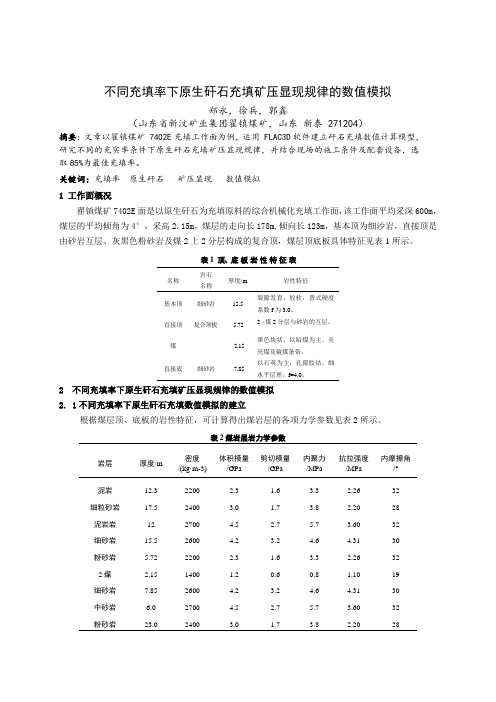
不同充填率下原生矸石充填矿压显现规律的数值模拟郑永,徐兵,郭鑫(山东省新汶矿业集团翟镇煤矿,山东新泰 271204)摘要:文章以翟镇煤矿 7402E充填工作面为例,运用 FLAC3D软件建立矸石充填数值计算模型,研究不同的充实率条件下原生矸石充填矿压显现规律,并结合现场的施工条件及配套设备,选取85%为最佳充填率。
关键词:充填率原生矸石矿压显现数值模拟1 工作面概况翟镇煤矿7402E面是以原生矸石为充填原料的综合机械化充填工作面,该工作面平均采深600m,煤层的平均倾角为4°,采高2.15m,煤层的走向长178m,倾向长123m,基本顶为细沙岩,直接顶是由砂岩互层、灰黑色粉砂岩及煤2上2分层构成的复合顶,煤层顶底板具体特征见表1所示。
表1 顶、底板岩性特征表名称岩石名称厚度/m 岩性特征基本顶细砂岩15.5 裂隙发育,较软,普式硬度系数f为3.0。
直接顶复合顶板 5.722上煤2分层与砂岩的互层。
煤 2.15 黑色块状,以暗煤为主,夹亮煤及镜煤条带。
直接底细砂岩7.85以石英为主,孔隙胶结,细2 不同充填率下原生矸石充填矿压显现规律的数值模拟2. 1不同充填率下原生矸石充填数值模拟的建立根据煤层顶、底板的岩性特征,可计算得出煤岩层的各项力学参数见表2所示。
表2煤岩层岩力学参数岩层厚度/m密度/(kg·m-3)体积模量/GPa剪切模量/GPa内聚力/MPa抗拉强度/MPa内摩擦角/°泥岩12.3 2200 2.3 1.6 3.3 2.26 32 细粒砂岩17.5 2400 3.0 1.7 3.8 2.20 28 泥岩岩12 2700 4.5 2.7 5.7 3.60 32 细砂岩15.5 2600 4.2 3.2 4.6 4.31 30 粉砂岩 5.72 2200 2.3 1.6 3.3 2.26 32 2煤 2.15 1400 1.2 0.6 0.8 1.10 19 细砂岩7.85 2600 4.2 3.2 4.6 4.31 30 中砂岩 6.0 2700 4.5 2.7 5.7 3.60 32 粉砂岩23.0 2400 3.0 1.7 3.8 2.20 281)采空区顶板垂直应力大小自下而上逐级递减,呈分层分布。
基于FLAC数值模拟的膏体充填控制覆岩变形与地表沉陷分析发表时间:2020-11-05T15:47:01.143Z 来源:《工程管理前沿》2020年第22期作者:周雨垚,谢小平,黄省,王菊,梁芳[导读] 煤矿膏体充填开采是一种有效的解决煤矿开采对水资源、土地资源、建周雨垚,谢小平,黄省,王菊,梁芳贵州六盘水师范学院矿业与土木工程学院,贵州,六盘水,553004摘要:煤矿膏体充填开采是一种有效的解决煤矿开采对水资源、土地资源、建筑物等造成破坏的开采方法,相对于其它垮落法开采、条带开采、离层区注浆、水砂充填等开采技术而言,具有安全性高、采出率高、环境友好等优点。
本论文从理论和实践上,着重研究了膏体充填开采岩层移动变形与地表沉陷控制的相关问题,采用数值计算的方法,分析了充填开采时顶板岩层的移动变形过程及支承压力分布特征,并对充填开采覆岩变形破坏进行了分类,明确了充填开采岩层控制的关键是控制直接顶及下位老顶的移动变形。
关键词:膏体充填;采空区;矿山压力;地表沉陷;数值模拟;中图分类号:TD 823 文献标识码:A1 工程概况膏体充填的试验地点矿井田北翼-300 m水平至-190 m水平之间的14259工作面,埋藏深度352~407 m,地面标高为+197 m,工作面标高为-155 ~ -210。
储量29.5万t。
原方案采用条带开采,开采条带宽45m,煤柱条带宽75m,两层煤垂直重叠布置,共布置8个工作面如图1-1所示。
其中,野青布置四个,分别是14457、14459、14461、14463条带工作面,大煤布置4个,分别是14257、14259、14261、14263条带工作面。
目前,野青的四个条带工作面(14457、14459、14461、14463)已经采完;大煤14257垮落法放顶煤条带工作面也已经采完。
14259工作面开采2#煤层,顶板为二级II类,工作面顶底板柱状图如图1-2所示。
其中,直接顶板为粉砂岩,厚度2~14 m,直接顶垮落步距6~8 m,老顶为细砂岩,平均厚度11.25 m。

福 建 建 筑Fueian Aechitectuee& Consteuction2021年第03期总第273期No 03 • 2021Vol - 273基于FLAC3D 的软基路段管廊路基施工期沉降数值模拟陈宗燕(福州新区交通建设有限责任公司 福建福州350000)摘要:为揭示不同施工阶段软基路段管廊路基的沉降特性,基于摩尔库伦屈服准则,采用FLAC3D 软件对施工期三个阶段的沉降进行模拟。
结果表明:支护开挖过程中,差异沉降率(位移量与距离基坑中心点之比)为0.17%左右,地 表沉降量与距离基坑边的距离呈“V ”型分布。
而坑底的隆起量呈拱形分布,且最大隆起量约为最小隆起量的10倍% 在管廊主体及基坑回填阶段,基坑的差异沉降率达0. 275%,由于地下水的浮力以及开挖引起的隆起,管廊对路基底面竖向位移的影响呈“钟”型分布%在路基回填阶段,差异沉降率分别为0.35%和0. 067%,路基底面和顶面的沉降曲线 呈“ W ”型%关键词:综合管廊;路基沉降;FLAC3D ;软基段中图分类号:U416. 1 文献标识码:A 文章编号:1004 -6135(2021)03 -0070 -07FLAC 3 D - baseC Numerical Simulation of Subgrade Settlement During ConstructionofPipe Gallery and RoadbeC on Soft GroundCHEN Zongyan,(Fuzhou New Area Transportation Construction Co. ,Ltd , Fuzhou 350000)Abstract : In order te reveal the settlement characteristics of the existing pipe gallery embankment in dilerent construction staaes ,based on the Mohr Coulomb criterion ,FLAC3D software was used te simulate the settlement of the three staaes of the construction period. The re sults show that during the excavation of the support ,the surface settlement and the distance from the edge of the foundation pit are distribu ted in a " V" shape ,and the diZerential settlement rate (the ratio of the displacement te the center of the foundation pit) is about 0. 17% . The uplift at the bottom of the pit is diswiduwd in an arch shape ,and the maximum uplift is about 10 times the minimum uplife During1hemain bodsoo1hepipega e esand 1heooundaion pibackoi i ngsage ,due o1hebuosancsoo1hegeoundwaeeand 1heupaiocaused bs the excavation ,the infuence of the pipe gallery on the vertical displacement of the road base surface is in a "bell" - shaped distribution ,and the settlement dlFerence rate of the foundation pit reaches 0. 275%. In the subgrade backfilling staae ,the settlement curve of the base and top ootheeoad is"W"-shaped ,and the se t aement di o e eence eate is 0. 35% and 0.067%.Keywords : Intearated pipe gallery ; Roadbed settlement ; FLAC3D ; Soft foundation sectiono 引言早在19世纪,国外部分发达国家就开始了城市 地下管廊建设研究,国内自2013年国务院提出开展 地下综合管廊工程试点起[1],加上一系列相应的配套政策陆续出台,地下综合管廊在国内各地的建设也按下了快进键%仅2019年,新开地下综合管廊项目就 超过百个,总投资约1400亿元[2] %作者简介:陈宗燕(1979.08 -),男,高级工程师。
基于FLAC3D的矿山开采沉陷数值模拟研究中国经济的快速发展,对能源的需求量越来越大,特别是煤矿资源。
煤矿被开挖出之后,矿区岩体的原有应力会发生很大的变化,当应力的改变超出一定范围,则地表产生移动和变形,这将给社会和环境带来巨大的问题。
因此开展开采沉陷的研究显得尤为重要,掌握地表沉陷规律就可以采取适当的措施避免地下开采的有害影响。
本文阐述了顾北矿某首采工作面的基本情况和地质资料,并以工作面的地质资料为基础,利用编写的程序导入到FLAC3D模拟软件中进行数值模拟试验,模拟矿山不同推进进度、不同煤层采厚、不同煤层倾角情况下地表移动变形规律,为矿山开采沉陷工程实践提供依据和方法,得出的规律如下:1.推进进度的影响:随着工作面的不断推进,地表最大下沉值和水平移动值不断增大,采空区也不断扩大,采空区上覆岩体塌落的高度和范围也将增大。
走向方向的最大下沉值点位于采空区中央上方且以最大下沉值为中心曲线两边对称,倾向方向的最大下沉值关于采空区中央呈现对称状态。
2.煤层采厚的影响:随着煤层采厚的不断增加,垂直方向的最大下沉值不断增大,水平位移值也不断增大,其下沉对地表的影响范围基本保持不变。
3.煤层倾角的影响:当煤层开采倾角的增大时,倾向方向最大下沉值不断减小,且最大下沉值点不位于采空区正中央,而是往煤层上山方向移动,下山方向的水平位移值不断减小,上山方向的水平位移值不断增大。
下煤层充填开采充实率设计的数值模拟王冰;郭广礼;李怀展;郭庆彪【摘要】多煤层开采时,下煤层充填开采效果会直接影响地表移动变形值。
充实率越高,地表缓沉效果越明显,但其开采成本也越高。
基于此矛盾点,利用FLAC3D 数值模拟软件,系统地研究了某矿区下煤层不同充实率方案时地表移动变形值的变化规律。
实验结果表明:①随着充实率的提高,地表移动变形值是呈负指数函数减小的,直至趋于某值后不再变化;②在充实率为80%时,地表最大下沉值为750 mm、最大倾斜变形值为1.5 mm/m、最大水平移动值为1.4 mm/m,均满足规程要求。
不仅能保证地面建(构)筑物的安全,还能达到最优的经济效益。
研究成果对于指导下煤层充填开采具有十分重要的理论和现实意义。
%The filling effect of lower coal seam directly affects the surface movement and deformation in the multi-coal seam mining. The higher ratio of backfilling is,the more obviously the effect of surface subsidence decreases,but the higher the mining cost becomes. In view of this contradiction,and based on the FLAC3D numerical simulation software,the change law of the surface movement and deformation were studied systematically for different size of ratio of backfilling. The experimental re-sults showed that:①With the increase of ratio of backfilling,The value of surface movement and deformation is decreasing in negative exponent function,and no longer changes until it reaches a certain valu e.②When the ratio of backfilling is 80%,the maximum surface subsidence value is 750 mm,the maximum slope deformation value is 1. 5 mm/m,the maximum horizontal displacement deformation value is 1. 4 mm/m,and all of them conform tothe requirements of the regulations. Then,the safety of ground buildings( structures) can be ensured,and also the optimal economic benefits is achieved. The research results have important theoretical and practical significance for guiding backfilling mining of lower coal seam.【期刊名称】《金属矿山》【年(卷),期】2016(000)009【总页数】4页(P69-72)【关键词】条带开采;充实率设计;FLAC3D;地表移动变形【作者】王冰;郭广礼;李怀展;郭庆彪【作者单位】中国矿业大学环境与测绘学院,江苏徐州221008; 国土环境与灾害监测国家测绘地理信息局重点实验室,江苏徐州221008; 江苏省资源环境信息工程重点实验室,江苏徐州221008;中国矿业大学环境与测绘学院,江苏徐州221008; 国土环境与灾害监测国家测绘地理信息局重点实验室,江苏徐州221008; 江苏省资源环境信息工程重点实验室,江苏徐州221008;中国矿业大学环境与测绘学院,江苏徐州221008; 国土环境与灾害监测国家测绘地理信息局重点实验室,江苏徐州221008; 江苏省资源环境信息工程重点实验室,江苏徐州221008;中国矿业大学环境与测绘学院,江苏徐州221008; 国土环境与灾害监测国家测绘地理信息局重点实验室,江苏徐州221008; 江苏省资源环境信息工程重点实验室,江苏徐州221008【正文语种】中文【中图分类】TD325目前常用的沉陷控制方式有部分开采、充填开采、离层注浆等[1]。
收稿日期2020-11-11基金项目国家自然科学基金项目(编号:52074010);高等学校省级质量工程项目(编号:2017jyxm1246)。
作者简介王磊(1984—),男,副院长,副教授,博士(后),硕士研究生导师。
总第537期2021年第3期金属矿山METAL MINE基于MATLAB 和FLAC 3D 的开采沉陷仿真教学实验系统研发王磊滕超群江克贵(安徽理工大学空间信息与测绘工程学院,安徽淮南232001)摘要矿山开采岩层移动与地表沉陷机理及规律是《矿山开采沉陷学》的核心基础理论,其相关教学内容复杂且抽象,是课程教学的重点和难点。
针对常规教学方法课堂效果差,且现有开采沉陷计算机仿真教学存在诸多不足,综合矿山开采沉陷原理与方法、现有矿山开采沉陷研究热点问题以及前沿仿真教学设计方法,利用MATLAB 和FLAC 3D 平台研发了矿山开采沉陷仿真教学实验系统。
系统主要包括两个模块:①基于MATLAB 和FLAC 3D 耦合的岩层移动机理仿真模块。
该模块针对矿山开采岩层移动相关教学内容,通过对MATLAB 数值计算与表达功能和FLAC 3D 数值模拟功能的互补耦合,实现了对岩层移动机理和岩层移动规律的仿真。
②基于MATLAB GUI 的地表沉陷规律仿真模块。
该模块针对矿山开采地表沉陷相关教学内容,基于MATLAB GUI 开发了开采沉陷预计原理仿真、智能参数反演原理仿真和开采沉陷规律仿真3个地表沉陷规律仿真子模块,实现了对地表沉陷时空演化规律的仿真。
所开发的系统界面友好,操作简捷,通过人机交互界面与系统进行交流,可以让学生充分理解并掌握岩移机理和规律、开采沉陷原理,以及开展相关预计参数求解等创新性实验,从而有效提高教学质量和效果。
教学实践表明:所构建的教学实验系统可以极大地提高学生的理解能力,培养学生的创新精神和学习兴趣,可有效解决《矿山开采沉陷学》教学的瓶颈问题。
关键词开采沉陷模拟技术MTLABFLAC 3D仿真教学中图分类号TD325文献标志码A文章编号1001-1250(2021)-03-176-08DOI 10.19614/ki.jsks.202103025Study and Development of a Simulation Teaching Experiment System for Mining Subsidence Basedon MATLAB and FLAC 3DWANG Lei TENG Chaoqun JIANG Kegui (School of Spatial Informatics and Geomatics Engineering ,Anhui University of Science and Technology ,Huainan 232001,China )AbstractThe mechanism and laws of rock formation movement and surface subsidence in mining operation are thecore basic theories of Mining Subsidence Science .The relevant teaching content is complex and abstract ,which is the focus and difficulty of course teaching.In view of the poor classroom effect of conventional teaching methods ,and many shortcom⁃ings of existing computer simulation teaching of mining subsidence ,this paper comprehensively integrates the principles and methods of mining subsidence ,the current hot issues of mining subsidence studies and the advanced simulation teaching de⁃sign methods ,a simulation teaching experiment system for mining subsidence based on the MATLAB and FLAC 3D is con⁃strusted.The system mainly includes two modules:①The simulation module of rock formation movement mechanism based on the coupling of MATLAB and FLAC 3D .This module aims at the teaching content related to rock formation movement in mining ,and realizes the simulation of the rock formation movement mechanism and the law of formation movement throughthe complementary function coupling of MATLAB numerical calculation and expression and FLAC 3D numerical simulation.②The simulation module of surface subsidence law based on MATLAB GUI.This module is aimed at the related teaching content of surface subsidence in mining ,and based on MATLAB GUI ,developed three surface subsidence law simulation sub -modules ,namely ,mining subsidence prediction principle simulation ,intelligent parameter inversion principle simula⁃Series No.537March 2021176tion and mining subsidence law simulation,and realized the temporal and spatial law of surface subsidence simulation.The system developed in this paper has a friendly interface and simple operation,and students can fully understand the mecha⁃nism and law of rock movement,the principle of mining subsidence,and carry out innovative experiments of solving related prediction parameters by using the human-computer interface,so as to effectively improve the quality and effect of teaching. Teaching practice shows that students'comprehension can be greatly improved,and the innovative spirit and learning inter⁃est can be cultivated by using the constructed teaching experiment system.The research results of this paper is help for ef⁃fectively solving the bottleneck problem in the teaching of Mining Subsidence Science.Keywords mining subsidence,simulation technology,MTLAB,FLAC3D,simulation teaching《矿山开采沉陷学》是煤炭行业特色高校测绘工程专业的必修课程,也是数字矿山与沉陷控制学科的专业基础课程,课程包括变形监测、开采沉陷规律、开采沉陷灾害预测和防控以及矿山环境修复和治理等内容,涉及地质、采矿、测量、环境、力学、建筑、计算机等多个学科,属于典型的交叉学科课程。