FURUNOECDISMultipleChoiceTest古野电子海图题库测精彩试题
- 格式:doc
- 大小:28.59 KB
- 文档页数:15
《航海学(二三副)》一、单项选择题(共145题)1、电子海图数据是指描写海域地理信息和航海信息的数字化产品,是数字海图的一种。
从电子海图数据属性而言,下列说法正确的是______。
(176085:第11章电子海图显示与信息系统) (A-0,B-0,C-0,D-0,错误-0)A. 光栅海图是以空间数据和属性数据所组成的矢量数据描述海图及相关信息,光栅海图不可以被改正B. 矢量海图以空间数据和属性数据所组成的矢量数据描述海图及相关信息。
矢量数据可有多种文件格式按一定的方式保存信息C. 光栅海图是指以栅格形式(图像方式如TIF、JPG等格式文件)表示的数字海图,属非标准电子海图D. 矢量海图是指以栅格形式(图像方式如TIF、JPG等格式文件)表示的数字海图,属标准电子海图2、矢量海图的主要特点包括___。
(176585:第11章电子海图显示与信息系统) (A-0,B-0,C-0,D-0,错误-0)A:数据和可查询性、与存储介质无关B:更加安全C:数据和可查询性、与存储介质无关、物标可分类显示、可计算性D:显示美观3、关于矢量化海图和光栅扫描海图下列说法错误的是______。
(176090:第11章电子海图显示与信息系统)A. 光栅扫描海图可看作是纸质海图的复制品B. 光栅扫描海图可以进行选择性查询、显示和使用数据C. 矢量化海图是将数字化的海图信息分类存储的数据库D. 矢量化海图可以进行选择性查询、显示和使用数据4、ECDIS的航线监视能提供___。
(176594:第11章电子海图显示与信息系统) (A-0,B-0,C-0,D-0,错误-0)A:偏航报警、转向点提醒B:无海图提示C:油耗计算D:偏航报警、转向点提醒、转向点ETA、STG查询5、ECDIS中航线设计优越于手工航线设计是因为____。
(176598:第11章电子海图显示与信息系统) (A-0,B-0,C-0,D-0,错误-0)A:绘画美观B:安全自动检测C:参数自动计算、重复使用、安全自动检测D:用鼠标完成,设计简单6、ECDIS取代纸海图的主要条件是____。
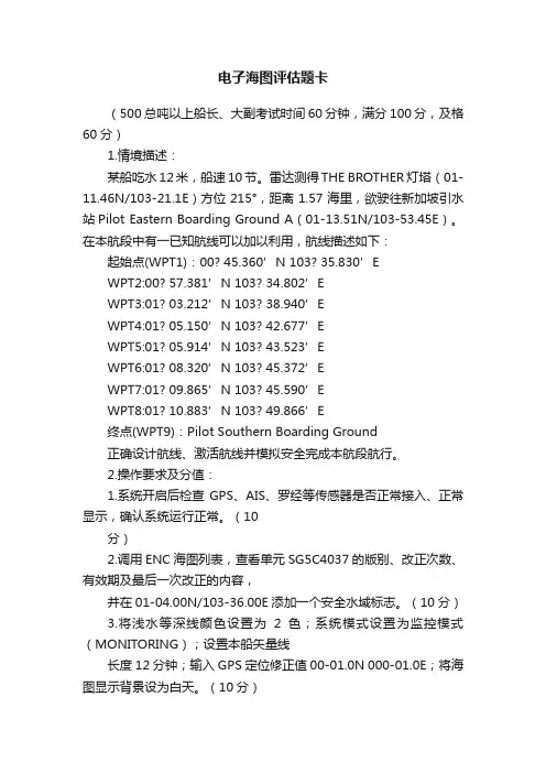
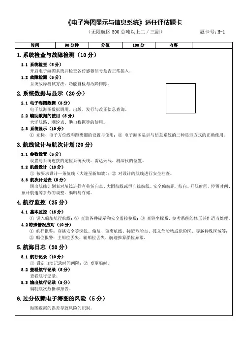
电子海图评估题卡(500总吨以上船长、大副考试时间60分钟,满分100分,及格60分)1.情境描述:某船吃水12米,船速10节。
雷达测得THE BROTHER灯塔(01-11.46N/103-21.1E)方位215°,距离1.57海里,欲驶往新加坡引水站Pilot Eastern Boarding Ground A(01-13.51N/103-53.45E)。
在本航段中有一已知航线可以加以利用,航线描述如下:起始点(WPT1):00? 45.360’N 103? 35.830’EWPT2:00? 57.381’N 103? 34.802’EWPT3:01? 03.212’N 103? 38.940’EWPT4:01? 05.150’N 103? 42.677’EWPT5:01? 05.914’N 103? 43.523’EWPT6:01? 08.320’N 103? 45.372’EWPT7:01? 09.865’N 103? 45.590’EWPT8:01? 10.883’N 103? 49.866’E终点(WPT9):Pilot Southern Boarding Ground正确设计航线、激活航线并模拟安全完成本航段航行。
2.操作要求及分值:1.系统开启后检查GPS、AIS、罗经等传感器是否正常接入、正常显示,确认系统运行正常。
(10分)2.调用ENC海图列表,查看单元SG5C4037的版别、改正次数、有效期及最后一次改正的内容,并在01-04.00N/103-36.00E添加一个安全水域标志。
(10分)3.将浅水等深线颜色设置为2色;系统模式设置为监控模式(MONITORING);设置本船矢量线长度12分钟;输入GPS定位修正值00-01.0N 000-01.0E;将海图显示背景设为白天。
(10分)4.根据本船资料(吃水、航速等)、海图资料等查看安全水深、安全等深线、深水等深线、浅水等深线、安全高度等的设置是否恰当。
ECDIS师资培训试题及参考答案ECDIS 培训试题1. ECDIS的主要作用是______。
A. 替代纸海图的使用B. 减少船上配员C. 确保航行安全D. 使船舶导航自动化2. ECDIS的主要优势是______。
A. 简单可靠的ENC数据更新B. 减少船舶工作量C. 提供恰当的报警或提示D. 以上都是3. 必须与ECDIS相连接的外部设备是______。
A. 雷达/ARPAB. 船舶定位系统(如GPS)C. 航迹控制系统(自动舵)D.AIS4. ECDIS显示除了基础显示和标准显示外,由谁来决定其他信息显示中的有关信息的显示______? A. 发布ENC数据的水道测量部门 B.ECDIS生产商 C. 船舶驾驶员 D. 以上都是5. 等效更新的纸海图的是______。
A.ENCB.SENCC.ECDIS的显示D. 数字格式的官方更新信息6. 下列不是IMO/IHO所规定的ECDIS至少必须显示的信息是______。
A. 水道测量数据B. 助航物标C. 潮流D. 规定的边界7. 下列是IMO/IHO所规定的ECDIS至少必须显示的信息是______。
A. 水道测量数据B. 渡轮航线C. 规定的边界D. 以上都是8. ECDIS中应显示的数字海图数据格式包括______。
A. 只有矢量海图B. 只有光栅海图C. 矢量和光栅海图均可D. 其他类型的海图9. ECDIS能显示的信息包括______。
A.ECDIS警报信息B. 官方水道部门数据C. 航海通告信息D. 以上都是10. ECDIS不能显示的信息有______。
A.ECDIS警报信息B. 官方水道部门数据C. 船舶水动力信息D. 航海通告信息11. 由通过ENC通过ECDIS转换得到的数据、ENC的更新数据和操作人员增加的额外数据等组成的信息称为____。
A. 基础显示信息 B. 标准显示信息 C.SENC D. 海图显示信息12. ECDIS首次运行必须显示的信息为______。
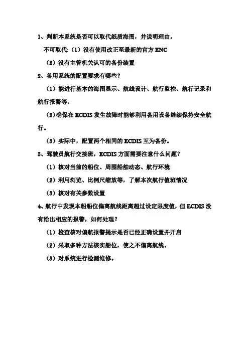
1、判断本系统是否可以取代纸质海图,并说明理由。
不可取代:(1)没有使用改正至最新的官方ENC
(2)没有主管机关认可的备份装置
2、备用系统的配置要求有哪些?
(1)能进行基本的海图显示、航线设计、航行监控、航行记录和航行报警等。
(2)确保在ECDIS发生故障时能够利用备用设备继续保持安全航行。
(3)实际中,配置两个相同的ECDIS互为备份。
3、驾驶员航行交接班,ECDIS方面需要注意什么问题?
(1)核对当前的船位、周围船舶动态、航行环境
(2)利用浏览、比例尺缩放等,了解本次航行值班情况
(3)核对有关参数设置
4、航行中发现本船船位偏离航线距离超过设定限度值,但ECDIS没有给出相应的报警,如何处理?
(1)检查核对偏航报警提示是否已经正确设置并开启
(2)采取多种方法核实船位,使之不偏离航线。
(3)对系统进行检测维修。
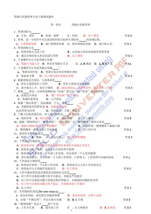
驾驶台资源管理与电子海图试题库第一部分驾驶台资源管理1、管理的职为:A、计划、组织B、协调、指挥C、控制D、以上都是答案D2、管理,是一个组织中为完成该组织的目标所从事的对的协调过程。
A、人和物质资源B、部门和物质资源C、组织和物质资源D、部门和人员。
答案D3、管理的特点是:A、管理其他人及其工作B、由其他人的活动体现管理的效果C、通过协调其他人的活动进行管理D、以上都对答案D4、下述哪些可认为是驾驶台资源A、驾驶台当值人员B、所有在驾驶台人员C、A, B 都是D、A, B 都不是答案A5、下述哪些可认为是驾驶台资源?A、驾驶员的经验B、驾驶台保存的各种操作规范C、夜航命令簿D、以上都可视为驾驶台资源答案D6、根据需要层次理论,人的需要是:A、所有人都是依次上升的B、所有人都是没有规律的C、部分依次上升,部分下降的D、除追求较高,心理异常外,都是依次上升的答案D7、根据理论,应采取强硬的或“松弛”的方法,或“权变”论进行管理。
A、需要层次理论B、“X”理论和“Y”理论C、保健因素理论D、公平理论答案B8、根据“强化理论”,如欲激励一个人,通常。
A、奖励和惩罚同样有效B、奖励更为有效C,惩罚更为有效D、因人而异,不能一概而论答案B9、了解人们的需要层次,对于进行船员的很有益处。
A、组织管理B、响应管理C、强制管理C、以上都对答案B10、根据“期望理论”,“激励力量”、“目标价效”及“期望概率”间的关系是。
A、激励力量=目标价效×期望概率B、目标价效一期望概率×激励力量C、期望概率一激励力量×目标价效D、以上均不对答案A11、领导的主要功能就是。
A、组织B、激励C、确定目标D、组织和激励答案D12、下列说法正确的是。
A、情景意识好,便能够识别失误链和在事故发生前制止其发生B、情景意识是天生的,无法从后天的培养中获得C、情景意识并不表明一个人的工作态度,仅仅表明一个人是否敏感D、丧失情景意识,并不影响一个人的工作绩效,只要努力,工作依然可以做的很好答案A13、下列说法正确的是。
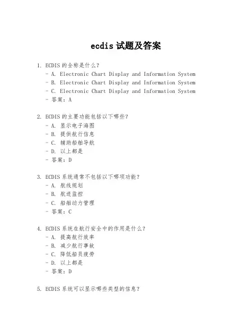
ecdis试题及答案1. ECDIS的全称是什么?- A. Electronic Chart Display and Information System - B. Electronic Chart Display and Information System - C. Electronic Chart Display and Information System - 答案:A2. ECDIS的主要功能包括以下哪些?- A. 显示电子海图- B. 提供航行信息- C. 辅助船舶导航- D. 以上都是- 答案:D3. ECDIS系统通常不包括以下哪项功能?- A. 航线规划- B. 航迹监控- C. 船舶动力管理- 答案:C4. ECDIS系统在航行安全中的作用是什么?- A. 提高航行效率- B. 减少航行事故- C. 降低船员疲劳- D. 以上都是- 答案:D5. ECDIS系统可以显示哪些类型的信息?- A. 航行警告- B. 天气信息- C. 船舶动态- D. 以上都是- 答案:D6. ECDIS系统在国际海事组织(IMO)中的地位如何? - A. 强制性设备- B. 推荐性设备- C. 非必要设备- 答案:A7. ECDIS系统的电子海图更新周期是多久?- A. 每天- B. 每周- C. 每月- 答案:C8. ECDIS系统在操作时,以下哪项操作是正确的?- A. 直接在屏幕上进行绘图- B. 使用专用工具进行标记- C. 不允许任何形式的修改- 答案:B9. ECDIS系统的电子海图数据来源是什么?- A. 国际海图机构- B. 船舶公司- C. 船员自行收集- 答案:A10. ECDIS系统在遇到故障时,应采取哪些措施?- A. 立即通知船长 - B. 切换到备用系统 - C. 记录故障信息 - D. 以上都是- 答案:D。
海图分类和使用题库1-1-8问题:[单选]中版海图图号是按()顺序编排的。
A.A.地区B.B.新版日期C.C.出版日期D.D.改版日期问题:[单选]要了解某张海图的现行版日期时可查阅()。
A.A.现行版航海图书总目录B.B.月末版航海通告C.C.季末版航海通告D.D.A+C问题:[单选]要了解某张海图的现行版日期时可查阅()。
Ⅰ.航海图书总目录;Ⅱ.英版航海通告累积表;Ⅲ.英版航海通告年度摘要;Ⅳ.季末版航海通告。
A.A.Ⅰ,ⅡB.B.Ⅱ,ⅢC.C.Ⅲ,ⅣD.D.以上都是/ 囚徒健身问题:[单选]一张图上资料的可信赖程度较高的海图应具有下列哪些特性()。
Ⅰ.新图或新版图;Ⅱ.新购置图;Ⅲ.现行版图;Ⅳ.比例尺尽可能大;Ⅴ.及时进行各项改正。
A.A.Ⅰ~ⅤB.B.Ⅱ,ⅣC.C.Ⅲ,ⅣD.D.Ⅲ~Ⅴ问题:[单选]下列哪些内容应成为航海员判定海图资料是否可信的依据()。
Ⅰ.测量时间;Ⅱ.海图比例尺;Ⅲ.新购置图;Ⅳ.航标位置;Ⅴ地貌精度。
A.A.Ⅰ~ⅤB.B.Ⅰ,Ⅱ,Ⅳ,ⅤC.C.Ⅱ,Ⅲ,ⅣD.D.Ⅲ~Ⅴ问题:[单选]使用资料陈旧、水深点稀少的海图,且航行在船舶活动较少的海区时,应()。
A.A.尽可能将航线设计在水面空白处B.B.尽可能将航线设计在水深点上C.C.尽可能将航线设计在水深点稀少处D.D.尽可能使航线与等深线垂直问题:[单选]英版海图、图书代销店负责其所销售()。
A.A.海图的永久性通告的改正B.B.海图的所有通告的改正C.C.所有图书资料的改正D.D.海图和灯标表的改正。
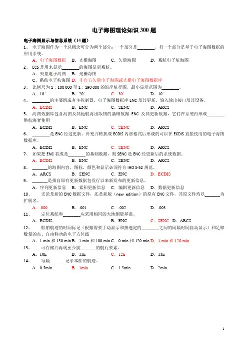
电子海图理论知识300题电子海图显示与信息系统(14题)1、电子海图作为一个总概念可分为两个部分:一个部分是________,另一个部分是基于电子海图数据的应用系统。
A.电子海图数据B.光栅海图C.矢量海图D.系统电子航海图2、ECS是用来显示________的海图显示系统。
A.矢量电子海图B.光栅海图C.系统电子航海图D.非官方矢量电子海图或光栅电子海图数据库3、比例尺为1∶100 000至1∶190 000的沿岸航行图,最小显示范围为________。
A.10′B.20′C.30′D.40′4、________的主要组成有主控制器、电子海图数据库ENC及其更新、输入输出接口及其设备。
A.ECDIS B.ENC C.SENC D.ARCS5、海图数据库包含海图及其他航海出版物的基础数据ENC及其更新数据,它们在系统内形成________供航海者使用A.ECDIS B.ENC C.SENC D.ARCS6、________是ENC经过更新、补充并转换成ECDIS内部格式后形成的可以在ECDIS直接使用的电子海图数据库。
A.ECDIS B.ENC C.SENC D.ARCS7、如果把ENC看成是________的基础数据,则SENC是ENC经更新后的系统数据。
A.ECDIS B.ENC C.SENC D.ARCS8、_______的海图内容、图标、颜色和显示必须符合IHO S-52规范。
A.ARCS B.SENC C.ENC D.ECDIS9、_______是指自原有更新数据包发行以来新发布的更新信息。
A.序列更新信息B.累积更新信息C.编辑更新信息D.数据更新信息10、无论是新的ENC数据文件,还是新版(new edition)的原有ENC文件,其原文件均以_______为扩展名。
A..000B..001 C..002 D..00311、定位系统和________应采用相同的大地测量基准。
A.ECDIS B.ENC C.SENC D.ARCS12、船舶航迹的时间标记(根据需要手动显示和按选定的________之间的间隔时间自动显示)和足够数量的点、自由移动的电子方位线A.1 min和130 min B.1 min和100 min C.0 min和120 min D.1 min和120 min13、可存储并再现至少前_______的航行要素。

1.ECDIS为:DA.电子海图B.电子海图系统C.光栅海图显示系统D.电子海图显示与信息系统2.ECS为:BA. 电子海图B.电子海图系统C.光栅海图显示系统D.电子海图显示与信息系统3.RCDS为:CA. 电子海图B.电子海图系统C.光栅海图显示系统D.电子海图显示与信息系统4.下列能够替代纸质海图的是?AA.ECDISB.ECSC.RCDSD.笔记本上安装的电子海图系统5.ENC为:AA.官方矢量海图B.官方光栅海图C.矢量海图D.光栅海图6.RNC为:BA.官方矢量海图B.官方光栅海图C.矢量海图D.光栅海图7.船上海图数据需要如何配置?DA.ENC或RNC均可B.ENCC.RNCD.ENC覆盖海域需要用ENC;ENC未覆盖海域,用RNC在加适当纸质海图8.ENC的大地坐标系是:BA.由各国航道部门决定B.WGS-84C.由ECDIS决定D.由航海人员决定9.RNC的大地坐标系是:BA.与原纸质海图一致B.WGS-84C.由ECDIS决定D.由航海人员决定10.有关ENC的说法错误的是:AA.相比RNC,占用的存储空间大B.根据S57标准编制编码,S63标准加密C.能分层显示D.能够提供一些智能化的功能,如拾取报告、搁浅预警等11.有关RNC的说法错误的是:DA.相比ENC,占用的存储空间大B.根据S-61标准制作C.是官方纸质海图的复制品D.能够提供一些智能化的功能,如拾取报告、搁浅预警等12.ECDIS工作在RCDS模式时,错误的是:DA.不能启动诸如防止搁浅的自动报警功能B.海图坐标系可能不是WGS84坐标系C.海图变向显示会影响海图资料的读取D.可以分层显示13.SENC是指:CA.官方矢量海图B.官方光栅海图C.系统电子航海图D.系统光栅航海图14.SRNC是指:DA.官方矢量海图B.官方光栅海图C.系统电子航海图D.系统光栅航海图15.作为船员,如何鉴别本船产品是否为ECDIS?DA.通过对系统操作,进行判断B.通过查看说明书C.询问厂家D.查看型式认可证书Type-Approval16.ENC的分发单位是图幅单元Cell,如某一Cell的编号为CN301301.000,说法正确的是:D代表数据生产商B.第三位数字表示海图的用途C.后缀.000表示海图为原始版本D.以上都对17.根据不同比例尺划分,一共有几种航海用途的ENC?DA.3B.4C.5D.618.ECDIS上面显示“”,代表什么含义?AA.海图精度最高B. 海图精度最低C.海图精度未定义D.以上都错19.ECDIS上面显示“”,代表什么含义?CA.海图精度最高B. 海图精度最低C.海图精度未定义D.以上都错20.ECDIS有何种分层显示方式?DA.基础显示base displayB.标准显示standard displayC.全部显示All other information D以上都对21.能够通过一键操作恢复的分层显示方式是?CA.基础显示base displayB.标准显示standard displayC.全部显示All other information D以上都对22.ECDIS由什么组成?DA.硬件设备B.系统软件C.海图数据D.以上都是23.下列何种传感器不是必须接入ECDIS的?DA.GNSS定位系统B.计程仪C.罗经D.雷达24.雷达图像叠显在ECDIS上,不完全重合的原因有?DA.ECDIS显示的船位不正确B.雷达增益、调谐、干扰抑制等调节不正确C.由于潮汐涨落,导致岸线淹没或露出D.以上都对25.ARPA目标为何在ECDIS不显示?DA.在雷达上未进行捕捉物标B.雷达与ECDIS之间的连接线故障C.ECDIS上未调用ARPA目标图层D.以上都有可能26.AIS目标为何在ECDIS不显示?DA.本船AIS未开机或者故障B.本船AIS与ECDIS之间连接线故障C.他船AIS未开机或者故障D.以上都有可能27.AIS相比雷达,其优点是:DA.天气与海况影响小B.没有假回波C.克服物标遮挡D.以上都对28.AIS相比雷达,其缺点是:DA.天气与海况影响小B.没有假回波C.克服物标遮挡D.是被动接收的29.雷达相比AIS,其优点是:DA.天气与海况影响小B.没有假回波C.克服物标遮挡D.是主动探测的30.安全等深线设置,需要特别注意?DA.根据本船吃水合理设置,若不设置,默认为30 米B.设置时要考虑到船舶富裕水深C.要注意海图水深是未包含潮汐的D.以上都对31.安全等深线设置不正确会引起?CA.设置过小,会导致水深不满足时,不发出搁浅报警B.设置过大,会造成不必要的误报警C.以上都对D.以上都不对32.ECDIS里面的报警和指示的含义是?CA.报警是指通过听觉或听觉加视觉进行报警,一般是指危机船舶安全的情况B.指示是指通过视觉给予船员提醒,较报警级别低C.以上都对D.以上都不对33.利用ECDIS进行航线设计,一般有哪几种形式?DA.利用航海图书资料,查询推荐航线,结合本船及气象条件进行设计B.利用已有的纸面或者GPS中的航线列表,转移至ECDISC.利用ECDIS中已有的航线,进行合并、反向、修改等进行设计D.以上都对34.如何鉴别ECDIS中显示船位的准确性?DA.通过查看船位的来源,若来源于GPS等卫星定位系统,一般精度满足需要B.有陆标可供定位时,可以采用传统陆标定位,对船位进行核实C.可以将雷达回波叠显在ECDIS上,查看回波图像与显著物标如雷康的吻合性D.以上都对35.ECDIS不能正确显示GPS船位的原因可能是?DA.本船GPS未开机或者GPS系统故障B.GPS与ECDIS之间的连接故障C.ECDIS未选择GPS作为船位传感器D.以上都对36.超比例尺显示over scale的风险是?CA.产生视觉差异,导致错误判断B.原图比例尺是最可靠的,超比例尺显示将原来制图误差也进行了放大C.以上都对D.以上都不对37.关于ECDIS的后备装置,可以是?CA.另外一套独立ECDIS的,有独立的定位传感器及电源B.全部航次需要的先行版改正最新的纸质海图C.以上都是D以上都不是38.ECDIS使用要注意?DA.设备经过ECDIS型式认可,并满足最新的IHO标准;使用足够的改正到最新的ENCB.有船旗国认可的后备装置C.船员经过通用类型及特定类型的培训,能够熟练操作使用D.以上都是39.如果配有2套ECDIS,未配置纸海图,在进出港等狭窄水域航行时要注意?CA.航线设计及计划要输入至备份系统中B.2套ECDIS都要开机,并保持可用状态C.以上都是D以上都不是40.验证航线有效性时,要特别注意?DA.选择合适的安全等深线及安全水深点B.自动验证后,需要显示全部信息,逐段人工查看C.航线改动或者海图更新后,需要重新验证D.以上都对41.ECDIS有类似“黑匣子”的功能,能够记录过去12小时以不超过1分钟的间隔记录一下数据:CA. 确保记录本船经过的航迹:时间、船位、首向和航速B. 确保记录使用过的正式数据:ENC信息源、版本、日期、单元和更新史C.以上都对D以上都不对42.若ECDIS出现报警或者指示,正确的操作是?BA.确认声响报警或指示,不作处理B.确认声响报警或指示,分析原因,采取应对措施C.不关心报警或者指示D.确认声响报警或指示,不分析原因,直接采取措施43.IHO S-52标准是指:AA.电子海图显示与信息系统海图内容与显示规范B. IHO数字海道测量数据传输标准C. 光栅海图产品规范D. IHO 数据保护方案44.IHO S-57标准是指:BA.电子海图显示与信息系统海图内容与显示规范B. IHO数字海道测量数据传输标准C.光栅海图产品规范D. IHO 数据保护方案45.IHO S-61标准是指:CA.电子海图显示与信息系统海图内容与显示规范B. IHO数字海道测量数据传输标准C.光栅海图产品规范D. IHO 数据保护方案46.IHO S-63标准是指:DA.电子海图显示与信息系统海图内容与显示规范B. IHO数字海道测量数据传输标准C.光栅海图产品规范D. IHO 数据保护方案1 如果设定的安全等深线不在显示的SENC中,则A、ECDIS则自动将其转化为下一个较浅的等深线B、ECDIS不会自动将其转化为其他等深线C、ECDIS则自动将其转化为下一个较深的等深线D、需要重新设定2 采用四色水深区显示时,其临界水深不包括A、安全水深B、浅水等深线C、安全等深线D、深水等深线3 关于比例尺棒的说法正确的是A、当显示比例尺大于1:80000时,画代表长度为10海里的比例尺棒B、当显示比例尺大于1:80000时,画代表长度为1海里的比例尺棒C、当显示比例尺小于1:80000时,画代表长度为1海里的比例尺棒D、当显示比例尺小于1:80000时,画代表长度为10海里的比例尺棒4、关于纬度尺的说法正确的是A、当显示比例尺大于1:80000时,画代表长度为10海里的比例尺棒B、当显示比例尺大于1:80000时,画代表长度为1海里的比例尺棒C、当显示比例尺小于1:80000时,画代表长度为1海里的比例尺棒D、当显示比例尺小于1:80000时,画代表长度为10海里的比例尺棒5、在ECDIS中,关于海图显示,下列说法错误的是A、可以在给定的投影方式下合成和显示海图B、不能隐去木船在特定航行条件下不需要的信息C、可以改变电子海图的比例尺D、可以分层次显示海图信息6、在ECDIS中,为便于比较和观察目标的真方位,采用下列哪种显示方式最合适?A、北向上B、航向向上C、船首向上D、航线向上7、在ECDIS中,关于显示方向,下列说法正确的是A、采用北向上时,文字、符号的方向保持不变B、采用航向向上时,文字、符号的方向保持不变C、采用船首向上时,文字、符号的方向保持不变D、采用航线向上时,文字、符号的方向保持不变8、在ECDIS中,关于显示方向,下列说法正确的是A、采用北向上时,指北符号的方向保持不变B、采用航向向上时,指北符号的方向保持不变C、采用船首向上时,指北符号的方向保持不变D、采用航线向上时,指北符号的方向保持不变9、根据IHO-52规定,ECDIS的显示背景肯定不包括下列哪项?A、白天B、夜间C、黎明D、黄昏10、下列哪项操作不能有效改变显示效果?A、改变显示背景B、调整显示器亮度和对比度C、增设滤光器或遮光板D、改变显示器的角度11、与传统的纸质海图相比,下列哪些符号是ECDIS新增的?A、沉船B、计划航线C、等深线D、冰区12、下列哪项不属于海员注记的表现形式?A、文字B、符号C、图形D、声音13、航线监控报警参数不包括:A、最大吃水B、偏航报警距离C、偏航角度D、旋回半径14、航线监控报警参数不包括:A、航道最大宽度B、偏航报警距离C、偏航角度D、旋回半径15、ECDIS不能根据下列哪项参数判断船舶是否有碰撞危险物的可能?A、设定的时间B、木船航向C、设定的距离D、木船航速16、关于木船符号采用基本符号还是比例船型,下列说法正确的是A、木船符号的类型是由海图显示比例尺决定的B、木船符号的类型是由使用人员设定的C、木船符号的类型是由海图显示比例尺和使用人员设定共同决定的D、木船符号的类型与海图显示比例尺和使用人员设定均无关17、下列关于木船符号的说法错误的是A、当比例尺较小(木船显示长度小于6毫米)时,木船符号可以以基本符号显示B、当比例尺较小(木船显示长度小于6毫米)时,木船符号可以以比例船型显示C、当比例尺较大(木船显示长度小于6毫米)时,木船符号可以以基本符号显示D、当比例尺较大(木船显示长度小于6毫米)时,木船符号可以以比例船型显示18、下列关于木船的符号说法正确的是A、任何情形下,均应使用比例船型B、任何情形下,均应使用基本符号C、在近岸、狭水道或靠泊航行时,选用比例船型更合适D、在近岸、狭水道或靠泊航行时,选用基本符号更合适19、在当前海图显示比例尺下换算所得的木船显示长度小于毫米时,木船的符号总以基本符号显示。

船员考试题库海员题库科目:航海学 011适用对象:无限航区500总吨及以上船舶二/三副1.关于ECDIS航行记录功能说法错误的是______。
A. 以1分钟的时间间隔记录过去12小时的本船航迹B. 以1分钟的时间间隔记录过去12小时所使用的ENC信息C. 以不超过4小时的时间间隔记录整个航次的全部航迹D. 以不超过1小时的时间间隔记录整个航次的报警/警示D2.如果观测的目标处于雨雪区域之后附近,正确的操作是______。
A. 使用雨雪抑制并适当降低增益B. 使用雨雪抑制并适当提高增益C. 不使用雨雪抑制直接提高增益D. 使用雨雪抑制并适当使用海浪抑制B3.使用船载航行数据记录仪的存储按键可将最近______小时记录的运行数据存储在可移动存储单元中。
A.3B.6C.12D.24C解析:船载航行数据记录仪应连续记录,所有存贮的数据项目应至少保留12h。
超过12h的数据项目可以由新的数据覆盖。
4.实际上,某地出现高潮的时间是______。
A. 0点B. 12点C. 月中天时刻D. 月中天之后D5.半圆周法方向换算为圆周法方向的法则是______。
A. 在SE半圆,圆周度数等于180°加上半圆度数B. 在NE半圆,圆周度数等于360°减去半圆度数C. 在SW半圆,圆周度数等于180°减去半圆度数D. 在NW半圆,圆周度数等于360°减去半圆度数D6.下列哪组云完全属于低云?A. Ci、Cu、StB. As、St、CsC. St、Cu、NsD. Ac、Cc、CbC7.正握六分仪,将指标杆放在刻度弧的______附近,观测某天体检查六分仪的定镜差。
A.0°B.10°C.35°D.60°A8.好望角航线终年盛行大风,其风向多为______。
A. 偏西风B. 偏东风C. 偏北风D. 偏南风A解析:南半球30°S以南中高纬海域为咆哮西风带,终年盛行强劲的西风,为狂风恶浪区。
1. Which operation can you perform on the FURUNO ECDIS? ( B )a. I can play back my ship’s past track on the ECDISb. I can record my position manually on the RNCs.c. I can create Notes from my Voyage Log to document a voyage on the charts.d. I can set the ECDIS to include engine log information into the Voyage Log automatically.2. Which operation can you perform on the FURUNO ECDIS? ( A )a. I can record my position manually on the ENCs.b. I can set the ECDIS to automatically choosing a Safety contour based on my setting of ship’s maximum draft.c. I can set Ship’s maximum height to enable chart alerts from areas in the charts where there is not sufficient air draft.d. I can send a copy of my Route Plan to an AIS target as a Safety Message.3. Which operation can you perform on the FURUNO ECDIS? ( C )a. I can record target ship’s position in the Voyage log automatically.b. I can record a position fix manually by using just one distance and one bearing.c. I can playback my past voyage track on the charts.d. I can send my Route Plan and User Chart to a FURUNO GPS for display on the GPS.4. Which operation can you perform with the FURUNO ECDIS? ( D )a. I can send my Route Plan and User Chart to any RADAR for display on the RADAR.b. I can send my Route Plan and User Chart to any AIS for display on the AIS.c. I can send my Route Plan and User Chart to any GPS for display on the GPS.d. I can send my Route Plan and User Chart to a FURUNO RADAR for display on the RADAR.5. Which operation can you perform during a voyage? ( A )a. I can use the Event function to record special events in the Event Log.b. I can create a User Chart from the Alert Log and save it to a USB memory device.c. I can create a User Chart from the Chart Usage Log and save it to a USB memory device.d. I can create a User Chart from the Voyage Log and save it to a USB memory device.6. Which operation can you perform after completion of a voyage? ( D )a. I can add additional records of manual positions to the Voyage Log adding further details to the past voyage.b. I can create a User Chart from the monitored Route Plan and save it to a USB memory device.c. I can create a backup copy of the Voyage log on a USB memory device.d. I can view and print a copy of the Chart Usage Log.7. Which operation can you perform during a voyage or after completion of a voyage? ( B )a. I can use the Event function to record special events in the Details Log.b. I can view and print a copy of the Voyage Log. (或更换为Details Log)c. I can create a backup copy of Own Ship’s past track (120 minutes max.) on a USB memory device and keep the copy in a safe location for future reference.d. I can reset the Chart Usage Log after creating a backup copy.8. What is a Manual Update? ( B )a. A Manual Update is an update applied using the Manual function in Load & Update Charts.b. A Manual Update is an update to the charts created by the operator from information received from the Pilot – a Navtex message – a VHF broadcast etc.c. A Manual Update is an update applied to the charts by an official representative of the chartproducer.d. A Manual Update is a chart created using the digitizer function of the FURUNO ECDIS.9. When do you use Manual Update? ( B )a. Always when I have to update my charts.b. When I receive information which must be displayed on my ECDIS and this is not yet included in the official weekly updates.c. I should never use Manual Updates.d. When I have to update the software of the ECDIS.10. Where can Manual Updates be displayed? ( D )a. Only on ENCs.b. Only on RNCs.c. Only on Vector Charts.d. On all types of charts in the ECDIS.11. How can you see if a chart object is created using Manual Updated? ( D )a. The Manual Update will be larger than any other chart objects.b. It is always shown in red.c. It will have a special orange marker.d. There is no way I can see if a chart object is created using Manual Updates.12. Can you copy your Manual Updates from one FURUNO ECDIS to another? ( A )a. No.b. Yes-by using the Backup and Restore dialogue to transfer the Manual Updates to a USB.c. Yes-by sending the Manual updates via an email.d. No-but I can transfer them to another manufacturer’s type of ECDIS.13. Can you create a Manual Update from an AIS Safety Message shown on the ECDIS? ( A )a. Yes-by manually creating the object.b. Yes-by letting the ECDIS create the object automatically.c. Yes-either by creating it manually or letting the ECDIS create it automatically.d. No.14. Can you create a Manual Update from an Navtex Message shown on the ECDIS? ( A )a. Yes-by manually creating the object.b. Yes-by letting the ECDIS create the object automatically.c. Yes-either by creating it manually or letting the ECDIS create it automatically.d. No.15. What should you remember to set up before planning a route? ( D )a. The setting for the Voyage Log.b. The Alarm Level in the Operation submenu.c. The Conning Display in Installation Parameters.d. The Chart Viewing Dates.16. What should you do if you have to leave your planned route during a voyage? ( D )a. Switch off the FURUNO ECDIS and concentrate on the RADAR.b. Disable the route monitoring on the FURUNO ECDIS.c. Change the display of the FURUNO ECDIS to IMO All Other.d. Configure and enable the Check Area function to assist me in scanning the ENCs for danger to navigation and hazardous objects.17. How do you record Own Ship’s position on the ECDIS charts when you have aRange/Bearing observation from your RADAR? ( B )a. I cannot record own ship’s position manually on the FURUNO ECDIS.b. I record LOP in the Record function of the Event Log.c. I press the [CTRL] & [ACQ/ACT] button on the Control Unit.d. I select [Record] [Event Log] and [User Event] from the Instant Access bar and insert the observation in the Record User Event window.18. How do you document your previous voyage on the FURUNO ECDIS? ( D )a. I use my paper Logbook as documentation.b. I use my paper Logbook and my VDR or SVDR as documentation.c. I use the tracking function in the symbol display.d. I show a playback of my past voyage track on the charts.19. Where can you find a list of the Manual Updates that have been applied to the FURUNO ECDIS? ( B )a. In the Chart Legend.b. In the Manual Update Window.c. In the Chart Catalogue.d. In the Chart Display menu.20. Which color scheme is used for Manual update on the FURUNO ECDIS? ( B )a. Blue ENC symbols.b. Standard ENC symbols.c. Orange ENC symbols.d. Red ENC symbols.21. Where do you change the Target past position density? ( C )a. In the Quick Access bar.b. In Chart Display.c. In the symbol display.d. In the Status bar.22. Where do you change the Tracked Target size? ( C )a. In the Quick Access bar.b. In Chart Display.c. In the symbol display.d. In the Status bar.23. What does the alert number 495 indicate? ( A )a. Anchor watch errorb. Track control stopped.c. Steering parameter errord. Filter: Init. Error24. What does the alert number 635 indicate? (A)a. No official datab. Log errorc. Dual axis log (WT) errord. Dual axis log (BT) error25. What does the alert number 257 indicate? ( D )a. Heading sensor not availableb. Prg track: Need higher speedc. Prg track: Use radius Ctrld. Gyro 3 COM error26. What does the alert number 450 indicate? ( D )a. Route: Illegal To WPTb. RADAR comm. errorc. LAN adapter version errord. Heading sensor not available27. What does the alert number 640 indicate? ( B )a. Datum mismatchb. Chart align: Over 30 min.c. RADAR antenna ID errord. Gyro error (Trackpilot)28. Where do you set the Shallow Contour? ( C )a. In Chart Legendb. In Symbol Displayc. In Chart Alertd. In Chart Display29. Where do you set the Shallow Pattern? ( C )a. In Chart Displayb. In Symbol Displayc. In Basic Settingd. In chart catalogue30. Where do you set the Deep Contour? ( C )a. In Chart Legendb. In Symbol Displayc. In Chart Alertd. In Chart Display31. Where do you control the AIO? ( C )a. In Chart Legendb. In Symbol Displayc. In Chart Displayd. In Chart Catalogue32. When an ENC is outlined in Green in the Chart Catalogue – it means? ( A )a. License is valid – chart is up-to-dateb. License is valid – chart is NOT up-to-datec. License is available – chart not installedd. License is not available or has expired33. When an ENC is outlined in Yellow in the Chart Catalogue – it means? ( C )a. License is valid – chart is up-to-dateb. License is available – chart not installedc. License is valid – up-to-date status doubtfuld. License is not available or has expired34. Which information can you find in the Raster Chart Legend? ( D )a. Magnetic Variationb. Safety Contour settingc. Quality of datad. T&P Notice35. Which information can you find in the Raster Chart Legend? ( C )a. Edition numberb. Last displayed updatec. Edition dated. Update issue date36. Which information can you find in the Raster Chart Legend? ( B )a. Shallow Contourb. Chart Namec. Chart Viewing dated. Deep Contour37. Where can you find information concerning the charts stored on the HDD? ( C)a. On the Internetb. The Chief Officer will know.c. In the chart catalogued. In the Chart Display menu38. Which recording function is available in the FURUNO ECDIS? ( A )a. Danger Targets Logb. Engine Logc. Speed Logd. GPS Log39. Which recording function is available in the FURUNO ECDIS? ( C )a. AIS Logb. Engine Logc. Voyage Logd. RADAR Log40. Where do you set system priority of multiple GPS connected to the ECDIS? ( A)a. In the Sensor dialogueb. In Basic Settingc. In Ship and Route Parametersd. In Nav Tools41. Where do you find information on the software version of the FURUNO ECDIS? ( C )a. In the Voyage Logb. In the System dialogue of the Menuc. In the About dialogued. In the S52 Presentation Library42. Which ECDIS setting is adjusted in Ship and Route Parameters? ( D )a. Position offsetb. Safety Contourc. Alarm volumed. Ship’s maximum speed43. Which printing option is available for the User Chart? ( B )a. Circle Reportb. Full Reportc. System Reportd. Detailed Report44. What is the maximum limit of the Check Area? ( B )a. No limitb. 240min + 20NM + 5km + 999mc. 120min + 10NM + 3km + 500md. 999min + 999NM + 999km + 999m45. How do you hide (not delete) a Manual Update object? ( C )a. I select Clear from the Manual Updates menub. I select Undo Last from the Manual Updates menuc. I deselect that general type of chart object in the Chart Display dialogued. I deselect the option from the Symbol Display dialogue46. Can you set the overall maximum speed for a route plan? ( A )a. Yes in the Ship and Route parameters of the Menub. Yes in Chart Displayc. Yes in Optimization parametersd. Yes in the route planning tool47. Can you monitor a route even though it indicates an active Alert when you have completed the Route Plan Check? ( A )a. Yes – the only thing preventing me from monitoring would be an impossible Turn message in the WPT tab.b. Yes – if I enter the Service Safety Passwordc. Nod. It depends on the type of Alert generated (Safety Contour–Restricted Area–Caution Area etc.)48. How are loaded ENCs converted into SENCs when updating? ( A )a. The FURUNO ECDIS will normally convert the ENCs to SENCs automaticallyb. I must use the conversion tool from the Menuc. I cannot convert ENCs into SENCsd. I load the new Permit file using the file named ENC. PMT and then I use the S52 presentation Library from the System menu in the Chart Menu to convert the ENCs into SENCs.49. How do you manually record Own Ship’s current position in the Logs? ( D )a. By opening the Voyage Log and entering the current position.b. By right clicking on own ship icon on the user interface.c. By pressing the Record button on the Control Unit..d. By using the record position event function of the Event Log.50. How do you add navigational chart objects to the FURUNO ECDIS when you are required to do so byNotice To Mariners? (或改为a Navtex message / information received via VHF broadcast) ( B ) a. I cannot add any chart objects to the ECDIS unless they are included in the weekly update CDs.b. I use the Manual Updates function.c. I use the User Chart function.d. I use the Chart Edit function.51. Which of these setting generate an alarm from the Chart Alert setting? ( C )a. Shallow Contourb. Safety Depthc. Safety Contourd. Deep Contour52. Can you plan a route while you monitor another route? ( C )a. Nob. Yes but only if I have two ECDISc. Yes the route planning function is independent from the route monitoring function.d. Yes but I must select the same Safety Contour for both route plans.53. How do you save your route to the Hard Disc Drive when it has been edited? ( B )a. I don’t. The route is automatically saved to the hard disc drive whenever changes areapplied.b. I click on Save or Save As in the Route Planning tool.c. I select Save in the Backup and Restore dialogue.d. I click New in the Route Planning tool.54. What is the purpose of Kalman Filter? ( C )a. The Kalman filter is the Antivirus software running on the FURUNO ECDIS.b. The filter is used to calculate an astronomical position from several astronomical observations entered by the operator.c. The filter continuously monitors the position given by each individual position sensor to determine if the sensor is reliable or not.d. The filter is used to verify the quality of data on the Base and Update CDs.55. How do you switch the Kalman filter on or off? ( B )a. The Kalman filter is always switched on when a route is put into monitor mode and switched off when there is no route being monitored.b. The Kalman filter is always on so I never have to switch it on or off.c. The Kalman filter is switched on or off in the Sensor menu on the Position tab.d. The Kalman filter is switched on when steering is switched to Autopilot.56. How do you update your vector charts on the Furuno ECDIS using the ENC update CD? ( A )a. I use the AutoLoad function.b. I create a Manual Update from the information on the CD.c. I create a User chart.d. I import the information using the Chart Details function in the Chart Catalogue.57. Which setting can be changed in Sensors? ( A )a. Log stabilization mode.b. Safety Contour setting.c. Safety Depth setting.d. Kalman Filter setting.58. How do you open the User Chart planning tool? ( A )a. I select “Planning” and then “User Chart” in the Quick Access bar when in Plan mode.b. I select “Planning” and then “User Chart” in the Quick Access bar when in Navi mode.c. I select Manual Update from the Menu in Charts mode.d. I left click on User Chart in the information sidebar – then I select Plan.59. Where do you select the color Palette used to display the charts? ( C )a. In Chart Legend.b. In Chart Display.c. In Quick Access Bar.d. In Chart Catalogue.60. Where do you control the settings and visibility of the chart layers? ( C )a. In Chart Legendb. In Symbol Displayc. In Chart Displayd. In Basic Setting61. Where do you control the visibility of the user overlays (User Chart – Route – etc.)? ( B )a. In Chart Legendb. In Symbol Displayc. In Chart Displayd. In Chart Catalogue62-1. Where do you change the visibility of your User Chart (或改为monitored route / planned route/circles)? ( B )a. In Chart Legendb. In Symbol Displayc. In Chart Displayd. In Chart Catalogue62-2. Where do you change the Ship Outlines (或改为Velocity Vectors style)? ( C )a. In the Quick Access barb. In Chart Displayc. In Symbol Displayd. In the Status bar63. How are regular T&Ps updated on the ECDIS? ( C )a. T&Ps must always be created as manual Updates.b. I create a Manual Update containing the T&Ps using the Manual function in the Load & Update function of the Chart Menu.c. Most T&Ps are included in the weekly update CD and these are updated automatically together with the other updates on the CD.d. I can not update T&Ps on the FURUNO ECDIS.64. Where can you update the ENCs? ( A )a. In the Chart Manager (Individual Update).b. In the Update function of chart displayc. In the Update function of the System settings.d. In the Update function of the Chart Legend.65. How can you reset the odometer? ( A )a. I can reset the odometer from the Voyage tab of the Menu.b. I can reset the odometer from the Sensor setting dialogue.c. I can reset the odometer from the Symbol Display dialogue.d. I can reset the odometer from the Quick Access sidebar.66. When the software of the FURUNO ECDIS is being updated – it is important that? ( C )a. The software should be loaded from a USB memory device.b. The FURUNO ECDIS is put in standby mode before updating.c. You create backup copies of all critical info in the ECDIS before updating.d. The ECDIS is disconnected from the RADRA.67. What should you remember to set up first when planning a route? ( C )a. The setting for the Voyage Log.b. The Alarm Level in the Operation submenu.c. The safety Contour in the route planning tool.d. The Radar overlay.68. Where can you enter information notes on Pilot data (VHF channels etc.) to be used during monitoring in the FURUNO ECDIS? ( D )a. In the Voyage Log.b. In the Pilot Data.c. In the User Event function.d. In the User Chart.69. How do you start the route planning tool? ( D )a. I press Plan on the Control Unit.b. I click on the Route icon in the Status bar.c. I select Route Plan from the Menu dialogue.d. I click on Route in the Quick Access bar.70. How do you modify an existing Manual Update object? ( D )a. I use the ENC tab of the Chart maintenance function.b. I use the Mainer tab of the Symbol Display function.c. I cannot modify a Manual Update – only delete it.d. I use the List tab of manual Update tool function.71. Where do you find information on the presentation library used in the FURUNO ECDIS? ( D )a. In the Basic Setting of the Menu.b. In the Record function of the Quick Access bar.c. In the System dialogue of the Menud. In the About dialogue72-1. How can you verify which route is being monitored? ( B )a. The name of the route will be displayed on my own ship vector.b. The name of the route will be displayed in the Route Information box.c. By right clicking on own ship icon.d. I cannot get information on the route which is being monitored.72-2. How can you verify which route is being monitored? ( C )a. By clicking on “Route” and then on “Route Info” in the Quick Access Sidebar in Plan mode.b. The name of the route will be displayed in the Status Bar.c. By clicking on “Route” and then on “Route Info” in the Quick Access Sidebar in Navi mode.d. I cannot get information on the route which is being monitored.73. How can you verify which User Chart is being monitored? ( D )a. The name of the User Chart will be displayed in the top right corner of the ECDIS screen.b. The name of the User Chart will be displayed in the information sidebar.c. By clicking on “Route” and then on “Route Info” in the Quick Access Bar when in Plan moded. By clicking on “Route” and then on “Route Info” in the Quick Access Bar when in Navi mode74. How can you tell if your FURUNO ECDIS is displaying an ENC? ( D )a. There is an “ENC Data available” indication in the Own Ship Function Box.b. There is an “RNC Data” indication in the Own Ship Function Box.c. The FURUNO ECDIS will give an audible alarm if I am not viewing an ENC.d. There is no special indication in the Own Ship Function Box.75. Where do you set up the chart watch sector to scan the ENCs for problems along own ship’s heading line? ( D )a. In Chart Display settingsb. In Chart Alert settingsc. In Basic settings.d. In Check Area settings.76. Which Manual Update objects can be hiden from view by operator selection? ( B )a. Only the Manual Updates Special Areas (from the Chart Display dialogue)b. All Manual Updates objects (from the Chart Display dialogue)c. Only the Manual Updates Buoys (from the Chart Display dialogue)d. Only the Manual Updates Soundings (from the Chart Display dialogue)77. Where can you change the setting of the Safety Contour which is used during planning of a route? ( D )a. Nowhere – because I must never change the setting for the Safety Contour.b. In the Settings menu and I can only change the setting if I have the passwordc. In chart alertd. In the route planning tool78. Where do you offset own ship chart position on the FURUNO ECDIS? ( D )a. In symbol displayb. In chart displayc. In chart menud. In own ship function box79. Where do you control the Safety Contour displayed on the charts on FURUNO ECDIS? ( A )a. In Chart Alertb. In the route planning tool – on the Alerts tabc. In Chart Displayd. No where – it is set up automatically80. Where do you find information on magnetic Variation in the ENCs on the FURUNO ECDIS? ( D )a. In Chart Displayb. In Chart Cataloguec. In Chart Alertd. In Chart Legend81. Can you edit a route without removing it from the route monitoring function? ( A )a. Nob. Yes but I must copy it to another ECDIS where it can be edited without interfering with the monitoring function of the FURUNO ECDIS.c. Yes if I create a copy of the route plan in ANTS format on a USB and edit the file on a normal office PCd. Yes if I select copy from monitor in the Route plan menu and edit the copy. When copying is completed I select-Exchange with monitor in the Route Plan Menu82. What is the name of category of charts generated by the user to draw up contingency areas –No Go areas – clearing lines etc.? ( C )a. Private Chartb. Pilot Datac. User Chartd. Non HO Chart83. Where can you display your planned or monitored User Charts on the FURUNO ECDIS? ( B )a. Only on official chartsb. On all chartsc. Only on vector chartsd. Only on raster charts84. How do you select which User Chart to monitor? ( A )a. By linking it to the monitored Route Plan in the route planning tool.b. By clicking Display – User Chart in the Quick Access Bar.c. By right clicking on the chart area.d. By left clicking on the chart area.85. How do you get information on an ENC object (Buoy-Beacon-Berth etc.) on the FURUNO ECDIS? ( C )a. I right click on the User Chart function in the route planning tool.b. I click on the Chart Info in the Instant Access Bar.c. I center click on the object.d. I right click on the object.86. How can you reset the trip counter? ( B )a. I can reset the Trip Counter by resetting the Voyage Log in the Reset submenu of the Record menu.b. I can reset the Trip Counter by resetting the Voyage tab of the Menu.c. I cannot reset the Trip Counter.d. The Trip Counter can be reset by deleting it using the Backup and Restore dialogue.87. What is a Point in the User Chart? ( B )a. A point is used to create a Manual Update from a chart object.b. A point is used to denote/highlight the position of a chart object with the User Chart.c. A point is the end of a User Chart.d. A point is used to connect the User Chart with a route plan.88. Where do you switch between Multicolor and Two Color setting for the charts? ( C )a. In Chart Legend.b. In Symbol Display.c. In Basic Settingd. In Chart Display89. How do you change the User Chart being used for monitoring? ( A )a. I move the monitored route plan to planning mode and edit the Linked User Chart setting.b. I select a different user chart from the Menu to monitor.c. I select User Chart from the planning sidebar and then I select Monitor for the desired user chart.d. I left click on User Chart in the Status Bar and then I select Plan.90. How do you enter information notes in the User Chart? ( A )a. I select Note as an option for the Area Line or Circle where the information should be displayed.b. I select Note as an option for the Tidal Label or Clearing Line where the information should be displayed.c. I select User Chart from the Main menu and then I select Plan and enter the note to be displayed.d. I left click on Route in the Quick Access Bar and then I select Monitor91. What is the recommended loading sequence when you receive new charts-updates and permits? ( D )a. There is no recommended sequence.b. #1:Base CDs#2: Update CD #3: Permitc. #1: Permit #2: Update CD #3: Base CDsd. #1: Permit #2: Base CDs #3: Update CD92. Can you edit the User Chart when the ECDIS is in Navi mode? ( D )a. Yesb. Only if the User Chart is not linked to a route plan.c. Yes if the User Chart contains no tidal information.d. No.93. When the software of the FURUNO ECDIS is being updated – it is important that? ( A )a. The software is updated by a FURUNO Service Engineer.b. The software is updated by the Captain.c. The software is updated by the Ship’s Electrical Engineerd. The software is updated by an IMO representative.When an ENC is outlined in Magenta in the Chart Catalogue - it means? CA. License is valid - chart is up-to-date.B. License is valid - chart is NOT up-to-dateC. License is available - chart not installedD. License is valid - up-to-date status doubtful.What does the alert number 257 indicate? DA. Heading sensor not availableB. Prg track: Need higher speedC. Prg track: Use radius CtrlD. Gyro 3 COM errorWhat does the alert number 470 indicate? DA. WGS 84 not usedB. Different geodetic datumC. Sentence syntax errorD. Datum changeWhat does the alert number indicate? BA. Sensor adapter 1 COM timeoutB. Sensor adapter 2 COM timeoutC. Sensor adapter 3 COM timeoutD. Sensor adapter 4 COM timeout单选题] What does the alert number 640 indicate? BA. Datum mismatchB. Chart align: Over 30 min.C. RADAR antenna ID errorD. Gyro error (Trackpilot)What does the alert number 635 indicate? AA. No official dataB. Log errorC. Dual axis log (WT) errorD. Dual axis log (BT) errorWhat does the alert number 380 indicate? CA. Route: File read errorB. User chart: File not foundC. AIS COM errorD. User chart: File read error单选题] What does the alert number 495 indicate? AA. Anchor watch errorB. Track control stoppedC. Steering parameter errorD. Filter: Init. ErrorWhat does the alert number 450 indicate? DA. Route: Illegal To WPTB. RADAR comm. errorC. LAN adapter version errorD. Heading sensor not available单选题] What does the alert number 820 indicate? CA. AIS lostB. TT lostC. Navtex message receivedD. Cross track alarmWhich information can you find in the Vector Chart Legend? CA. Notices To MarinersB. Presentation Library edition numberC. Chart edition && Update dateD. Safety Contour settingWhen an ENC is outlined in Magenta in the Chart Catalogue - it means? CA. License is valid - chart is up-to-date.B. License is valid - chart is NOT up-to-dateC. License is available - chart not installedD. License is valid - up-to-date status doubtful.单选题] When an ENC is outlined in Yellow in the Chart Catalogue - it means? CA. License is valid - chart is NOT up-to-date.B. License is available - chart not installeD:C. License is valid - up-to-date status doubtful.D. License is not available or has expireD:When an ENC is outlined in Red in the Chart Catalogue - it means? DA. License is valid - chart is NOT up-to-date.B. License is available - chart not installeD:C. License is valid - up-to-date status doubtful.D. License is not available or has expiredWhen an ENC is outlined in Blue in the Chart Catalogue - it means? DA. License is valid - chart is up-to-date.B. License is valid - chart is NOT up-to-date.C. License is available - chart not installeD:D. Cancelled chart.When an ENC is outlined in Orange in the Chart Catalogue - it means? BA. License is valid - chart is up-to-date.B. License is valid - chart is NOT up-to-date.C. License is available - chart not installeD:D. Cancelled chart.When an ENC is outlined in Green in the Chart Catalogue - it means? AA. License is valid - chart is up-to-date.B. License is valid - chart is NOT up-to-date.C. License is available - chart not installeD:D. License is not available or has expireD:。