凯立德GPS移动导航系统用户手册
- 格式:pdf
- 大小:7.93 MB
- 文档页数:39
刚刚完成车载gps凯立德地图升级,在升级过程中发现网上许多教程难免有错误,遂将自己的过程和见解放出。
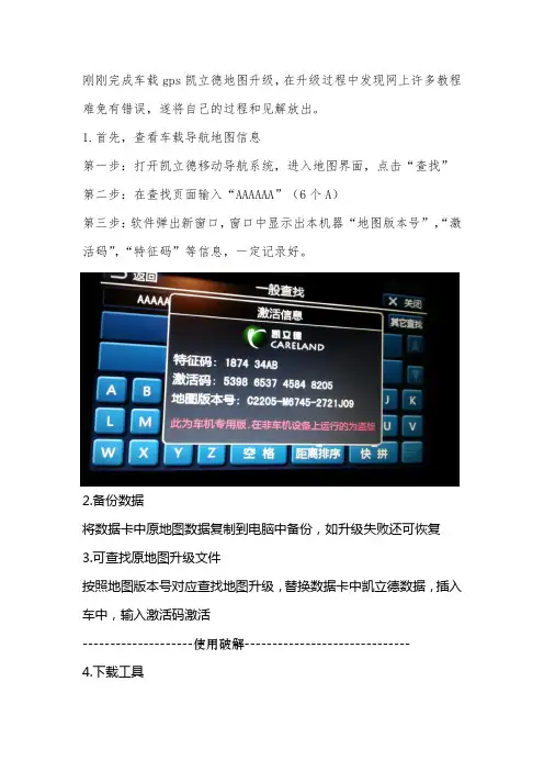
1.首先,查看车载导航地图信息第一步:打开凯立德移动导航系统,进入地图界面,点击“查找”第二步:在查找页面输入“AAAAAA”(6个A)第三步:软件弹出新窗口,窗口中显示出本机器“地图版本号”,“激活码”,“特征码”等信息,一定记录好。
2.备份数据将数据卡中原地图数据复制到电脑中备份,如升级失败还可恢复3.可查找原地图升级文件按照地图版本号对应查找地图升级,替换数据卡中凯立德数据,插入车中,输入激活码激活--------------------使用破解------------------------------ 4.下载工具如使用其他破解地图升级亦可,此时需要了解原地图的屏幕尺寸、gps 端口(设置不对搜不到卫星)、gps波特率(影响信号传输)等信息需要使用工具:凯立德端口配置工具、凯立德参数修改器。
我的百度盘提供下载(/s/1eQxMEL8/s/18Km0u)或网上搜一下,有很多。
5.查看参数使用凯立德参数修改器了解车载gps参数。
将凯立德参数修改器拷贝到数据卡中,打开。
拖动NaviResFile文件夹中NaviConfig.dll文件到凯立德参数修改器中打开,见下图。
记录下下图圈出的数据。
6.下载破解地图文件我是用的版本号为C1204-C7H01-3121J0H,电子眼为201403000,是凯立德2014年春季高清零售版,分辨率800X480。
默认端口COM1 波特率9600;下载地址/s/1jGDn9sE7.修改地图参数将下载得到NaviOne压缩文件夹,解压后即可得到NaviOne文件夹。
解压后的NaviOne文件夹有3.49G,请准备足够容量的存储卡。
使用“凯立德端口配置工具”打开破解地图的NaviResFile文件夹中NaviConfig.dll文件,根据记录的GPS参数修改端口和波特率两个参数。
车载GPS导航仪使用说明书尊敬的用户,欢迎您购买并使用我们的车载GPS导航仪。
本使用说明书将为您提供详细的操作指南,以帮助您正确使用导航仪并获得最佳的导航体验。
一、产品概述车载GPS导航仪是一种基于全球定位系统(GPS)技术的导航设备。
它结合了卫星定位、地图数据库和导航软件,能够为您提供准确的车辆位置信息、路线规划以及导航指引等功能。
我们的产品具有以下特点:1.高精度定位:通过接收卫星信号,导航仪能够实时准确地定位您的车辆,提供精准的导航服务。
2.多功能导航:除了常规的驾车导航功能外,导航仪还提供步行、骑行等多种导航模式,并支持POI(兴趣点)搜索、线路规划等功能。
3.智能语音提示:导航仪内置语音合成技术,能够实时播报导航指引,让您无需分心看屏幕,更加安全便捷地进行导航。
二、使用方法1.前期准备在第一次使用前,请确保您已经将导航仪的电源充满,并正确插入车载支架。
您还需要安装地图数据,可通过我们提供的软件或者在线下载的方式进行。
2.开机与关机长按开关键一秒钟,导航仪即可开机启动。
在正常使用过程中,您可以通过点击界面上的关机按钮进行关闭。
3.地图操作使用触摸屏幕或者外部键盘进行地图操作。
您可以通过手势缩放、平移等方式调整地图显示区域。
另外,点击地图上的兴趣点或者目的地图标,即可进行相关操作,如导航规划、查看详细信息等。
4.导航设置导航仪提供了丰富的导航设置选项,您可以根据个人需求进行调整。
例如,您可以选择偏好路线、避开拥堵、设置声音提示等。
5.语音指引导航仪通过内置扬声器进行语音指引。
在导航过程中,您会听到详细的导航提示,包括转向指示、距离提示等。
您还可以根据需要调整音量大小或者关闭语音指引。
6.兴趣点搜索导航仪允许您搜索周边的兴趣点,如餐馆、加油站、酒店等。
您可以直接在搜索框中输入关键词,系统会为您提供相关的搜索结果,并进行导航到达。
三、常见问题与解答1.为什么导航仪无法定位?请确保导航仪在开放的区域使用,避免遮挡。
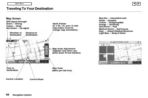
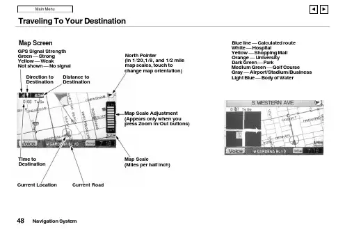
Traveling To Your DestinationBlue line — Calculated route White — HospitalYellow — Shopping Mall Orange — University Dark Green — ParkMedium Green — Golf CourseGray — Airport/Stadium/Business Light Blue — Body of WaterNavigation SystemMap ScreenGPS Signal Strength Green — Strong Yellow — WeakNot shown — No signalDistance to DestinationDirection to DestinationNorth Pointer(In 1/20, 1/8, and 1/2 mile map scales, touch tochange map orientation)Map Scale Adjustment (Appears only when you press Zoom In/Out buttons)Map Scale(Miles per half inch)Current RoadCurrent Location Time toDestinationTraveling To Your DestinationLandmark IconsLandmark icons will be shown in the screen if you select the "Show Icon on Map" in the "Set-up Screen". See "System Setup" on page 60.Going Off the RouteIf you leave the calculated route,"Off-route" (manual) or"Recalculating" (automatic) is displayed at the top of the screen.The system will recalculate the route from your current location anddirection to the desired destination;then give you a new route instruction.This recalculation is doneautomatically unless you set it to manual in the Setup Menu. See "System Setup" on page 60.Auto RecalculationIf this option is set to "Automatic"you will see. "Recalculating" flash at the top of the screen for several seconds as the system recalculates the route. This is followed by a new route instruction.Manual RecalculationIf this option is set to "Manual", you will hear a tone when the "Off-route"message is displayed. You must press the Joystick or "ReCal" icon in the screen before the system will recalculate your route.Navigation SystemTraveling To Your DestinationModifying the RouteSeveral functions in the system allow you to view the route the system has calculated. You can then have the system recalculate portions of the route. This is helpful if you are aware of road conditions along the calculated route that you wish to avoid.With the map screen displayed, you can push the MAP/GUIDE button at any time to display the guidance screen. With the guidance screen displayed, move the Joystick left or right to see the Direction List. This shows you all the route instructions between your current location and your destination.Instructions that have already been executed cannot be displayed.Push the joystick down to see the upcoming route instructions one at a time. Each push displays the next in-struction in the sequence. Push the joystick up to move backwardthrough the sequence to the current instruction. The display returns to the current route instruction in about 10 seconds if you stop pushing on the joystick.Navigation SystemTraveling To Your DestinationPressing the MENU button with either the map screen or theguidance screen displayed changes the display to:This menu lets you cancel or modify the current calculated route.DetourSelect this option if you encounter an unexpected obstacle, such as a closed road or extremely heavy traffic congestion. The system will calculate a route from your current location that detours you off the original route, and then back onto it after a certain distance.Avoid a StreetThis option lets you delete a street or streets from the current calculated route. This is helpful if you know of road construction or other snags on the prescribed route.Plan New TripSelecting this option cancels the current route and destination. The display returns to the "Main Menu".Back to Current RouteSelecting this option returns you to the original guidance screen.Navigation System。

凯立德【安卓零售版】使用说明一、界面和操作介绍:安卓零售版与车机的界面基本相同了,横屏显示,界面介绍如下(为便于介绍PS了下,后附具体说明):(一)浏览界面:1.路径规划:包括目的地、出发地、地址薄(家园版叫收藏夹),在导航状态下浏览地图时还会出现经由地选项。
此界面与浏览标(家园版叫光标了)、返回同时出现,需要在进入系统后或者在导航过程中长按屏幕(家园版为轻触)进入。
2.出发地、经由地(可选)和目的地:进入系统时只有车标和出发地或者代表当前位置的绿色圆点,在导航模式下才会出现目的地,如果有设置还会出现经由地。
3.指示栏:这里包括提示设置(可以选择安全、标准、简明三种提示方式)、地图模式设置(地图正北、图随车转、俯视图)和GPS指示。
4.电子眼:可以快速添加电子眼信息。
5.k码:进入k码显示和定位功能。
6.地图缩放和比例尺显示:比家园版多了个比例尺的显示。
7.底部菜单栏:包括功能(包含设置等,同家园版)、查找、常用(相当于家园版导航管理)、周边(快速查找目的地、导航路径、车标或浏览标周围的特定分类兴趣点)。
在它右边的三角箭头可以显示或者隐藏底部状态栏,再右边显示系统时间(导航模式下显示选路方式、剩余里程、剩余时间等信息)。
上方一点显示车标或者浏览标的地理位置(导航模式下还显示当地广播电台名称、频率)。
(二)导航界面:1.行程说明:进入行程说明界面,可以选择浏览或避开某一段路径。
2.目的地指示:显示目的地的名称。
3.复诵:点击可复诵上一次语音提示信息。
Ps:此图为俯视图模式,前方可以看得更远。
(三)操作介绍:1.地图移动:长按地图进入浏览模式,地图操作与家园版不同,移动地图时需点击目的位置,不支持地图拖拽。
2.定位:快速移动到该兴趣点所在位置,可以点击“上一个”、“下一个”定位到同列表中的其他兴趣点,也可以点击“周边”进入周边快速搜索。
3.改变位置和设定:进入浏览界面并定位到该兴趣点,移动地图到需要的位置后可以点击左侧的“设定”来完成对兴趣点的重新定位。
Traveling To Your DestinationBlue line — Calculated route White — HospitalYellow — Shopping Mall Orange — University Dark Green — ParkMedium Green — Golf CourseGray — Airport/Stadium/Business Light Blue — Body of WaterNavigation SystemMap ScreenGPS Signal Strength Green — Strong Yellow — WeakNot shown — No signalDistance to DestinationDirection to DestinationNorth Pointer(In 1/20,1/8, and 1/2 mile map scales, touch tochange map orientation)Map Scale Adjustment (Appears only when you press Zoom In/Out buttons)Map Scale(Miles per half inch)Time toDestination Current LocationCurrent RoadTraveling To Your DestinationLandmark IconsLandmark icons will be shown in the screen if you select the "Show Icon on Map" in the "Set-up Screen". See "System Setup" on page 60.Going Off the RouteIf you leave the calculated route,"Off-route" (manual) or"Recalculating" (automatic) is displayed at the top of the screen.The system will recalculate the route from your current location anddirection to the desired destination;then give you a new route instruction.This recalculation is doneautomatically unless you set it to manual in the Setup Menu. See "System Setup" on page 60.Auto RecalculationIf this option is set to "Automatic"you will see. "Recalculating" flash at the top of the screen for several seconds as the system recalculates the route. This is followed by a new route instruction.Manual RecalculationIf this option is set to "Manual", you will hear a tone when the "Off-route"message is displayed. You mustpress the Joystick or "ReCal" icon in the screen before the system will recalculate your route.Navigation SystemTraveling To Your DestinationModifying the RouteSeveral functions in the system allow you to view the route the system has calculated. You can then have the system recalculate portions of the route. This is helpful if you are aware of road conditions along the calculated route that you wish to avoid.With the map screen displayed, you can push the MAP/GUIDE button at any time to display the guidance screen. With the guidance screen displayed, move the Joystick left or right to see the Direction List. This shows you all the route instructions between your current location and your destination.Instructions that have already been executed cannot be displayed.Push the joystick down to see the upcoming route instructions one at a time. Each push displays the next in-struction in the sequence. Push the joystick up to move backwardthrough the sequence to the current instruction. The display returns to the current route instruction in about 10 seconds if you stop pushing on the joystick.Navigation SystemTraveling To Your DestinationPressing the MENU button with either the map screen or theguidance screen displayed changes the display to:This menu lets you cancel or modify the current calculated route.DetourSelect this option if you encounter an unexpected obstacle, such as a closed road or extremely heavy traffic congestion. The system will calculate a route from your current location that detours you off the original route, and then back onto it after a certain distance.Avoid a StreetThis option lets you delete a street or streets from the current calculated route. This is helpful if you know of road construction or other snags on the prescribed route.Plan New TripSelecting this option cancels the current route and destination. The display returns to the "Main Menu".Back to Current RouteSelecting this option returns you to the original guidance screen.Navigation System。
凯立德移动导航使用指南城市的道路建设以及汽车数量的增长十分之快,开着车穿梭于各大城市的朋友也越来越多,交叉如网状的道路相信会让不少开车的朋友迷茫不已。
正因为如此,有一个好的GPS全球卫星定位系统是很必要的。
今天我们就为大家介绍一下凯立德移动导航系统。
凯立德移动导航系统有两种安装方法,在选择了相应地区的地图及软件进行解压安装的时候程序会有提示,一种是通过同步的模式进行安装,另一种是将程序拷贝到存储卡上进行安装,两种安装方式由于安装文件即较大,数据线同步安装的方式过于缓慢,于是在安装的时候建议选用最快的存储卡安装方式(安装完成之后需创建一个快捷方式至程序菜单)。
不管采取何种安装方式,存储卡上必须有充足的空间,本次测试安装的是珠江三角洲地区的地图,所占的空间约为68M,如果要安装全国的导航地图则需要有一张剩余空间为512M以上的存储卡。
在程序安装完毕之后,首次运行时,输入根据每台手机唯一的设备识别码捆绑的激活码之后,即可开始正式使用凯立德移动导航系统了。
本次采用了GS-R232蓝牙GPS卫星接收机进行测试,体积小巧的卫星接收机适合放置在汽车的仸何位置,内置锂电池的设计,不仅适合车载使用,也适合在城市内的行走使用,内置的锂电池在全程GPS的定位使用下大概能够维持将近10个小时的使用。
长按GS-R232蓝牙GPS卫星接收机上的按键开启电源之后,接收机便自动进行卫星的寻找定位。
在空阔的地方,GS-R232的定位速度较快,大概在1~2分钟之内,而在高楼林立的城市内则需要3~5分钟的定位时间。
定位成功之后,长亮的橙色小灯则转为闪烁的状态。
在蓝牙GPS接收机成功的进行定位之后,开启凯立德移动导航软件,为了能够保障驾驶者的安全,软件会提示相关的注意事项,例如交通使用安全等事项。
按确认后即可进入程序的主运行界面,地图的界面便显示在屏幕上,默认坐标位置附近的建筑物或道路也会同时显示。
程序的地图有3种显示方式,分别为地图正北、随着行进方向旋转、以及鸟瞰图,用户可根据自己的习惯来进行选择,在使用的过程中,驾驶员则认为鸟瞰图的方式是最好的查看方式。
凯立德手机导航软件v3.02最新版下载说明0907凯立德, 手机, 软件, 导航, 下载新数据、新引擎、新功能、新设计、全新地图,凯立德手机导航软件将再次引领新一轮的手机导航流行风潮。
2009年7月初,凯立德手机导航软件又进行了一次大的版本升级,目前最新版本已经升级到V3.02。
此次更新后的软件版本将广泛的适用于Symbian S60V3、Windows Mobile 5.0/6.0/6.1及以上系统且具备GPS导航功能的大部分手机和部分Linux导航手机。
下载方式:请登录/down.php,进入以后选择自己的机型就可以下载了。
因为专业,所以心系关怀作为中国GPS导航软件第一品牌的凯立德,在导航领域的10年发展,其产品的专业性已经被广大用户所认可,所获得的各种奖项更是被业内人士所肯定。
此次发布的凯立德手机导航软件产品在之前众多产品的基础上除了为用户提供了更加专业的电子地图和导航功能外,软件的操作也更加人性化,无处不体现着软件对用户的关怀以及对用户真正需求的满足。
全功能全覆盖的免费贴身电子地图此次的版本升级,凯立德手机导航软件不仅为广大用户提供了基础导航数据的免费升级下载服务,同时还大范围的扩充了电子地图的兴趣点(POI)信息,为广大导航用户提供覆盖全国路网和包含750万个以上精确兴趣点(POI)的电子地图。
道路总里程200万公里,含括4个直辖市,33个省级行政区域(包含香港、澳门)以及25个省会城市,333个地级市,2862个县级行政单位,3万个乡镇级行政单位,部分沿海城市及经济发达地区,基本实现村村通。
软件本身还提供基于电子地图的免费地图浏览功能、快速查找目的地和兴趣点(POI)功能,极大的丰富了导航类手机软件的功能。
专业导航按需付费此次升级的凯立德手机导航软件为用户提供免费下载获取,免费导航服务,每次语音导航收取人民币2元的导航服务费用(不含GPRS流量费),不导航不收费。
相比众多的PC和PND (便携式自导航系统)导航软件几百元甚至上千元的导航费用来说可谓是为用户极大的节约了使用费用。
第一章什么是GPS第二章GPS的作用第三章GPS的实现方案第四章如何选择GPS第五章GPS软件地图第六章GPS使用注意事项第一章什么是GPSGPS(Global Positioning System)中文翻译就是“全球定位系统”,顾名思义,是用来定位的。
具体来说是通过在2万公里高空的美国的24颗卫星所发射免费的信号,通过接收设备,来确定您的具体位置的系统。
第二章GPS的作用1、车载导航通过专门的GPS导航设备,或者通过给您的手机、PDA、笔记本电脑添加GPS 模块(比如蓝牙GPS),配合专业的智能导航软件,实现行车过程中的路程搜索、目的地查询、路线规划与推荐、行车语音提示(比如前方200米右转进辅道,前方桥下掉头,前方1公里有服务区等),让路盲的您不用在问路了。
在您所在的城市里,想要去一个地方,这个地方你不知道,只要输入这个地方的名称,就会规划出行驶路线,而且可以先模拟导航。
可以设定时间最短、路程最短、不堵车优先。
在长途驾车旅游中,再也不用提前问怎么走高速,哪个路口出去,只要标出目的地,设定高速路优先等,都会帮您规划出您想要去的地方的最佳行车路线。
比如要从北京去新疆自驾车旅游,输入乌鲁木齐就可以。
当您偏离已经选定的路线,会提示您偏离航向,同时会自动给您重新规划路线。
具体可以看的模拟导航效果:/product/product.html 另外一款导航软件效果:/ProductIntro/function.asp 车载导航安装的效果:/thread-2549-1-1.htmlGPS使用心得:/forum-69-1.html猴哥觉得,车载导航设备是送给“路盲”女友的最好的礼物。
2、手持导航主要是在外出旅游、爬山、郊游等时候,用来规划路线、指示方位、记录旅游轨迹。
可以在爬一个山前,使用前人的爬山轨迹。
3、分享航迹、记录人生轨迹GPS设备都有记录航迹功能,比如您要到桂林甚至西藏自驾车旅游,您可以下载别人的航迹,然后就不用问路,直接按照这个航迹旅行。
刚刚完成车载gps凯立德地图升级,在升级过程中发现网上许多教程难免有错误,遂将自己的过程和见解放出。
1.首先,查看车载导航地图信息第一步:打开凯立德移动导航系统,进入地图界面,点击“查找”第二步:在查找页面输入“AAAAAA”(6个A)第三步:软件弹出新窗口,窗口中显示出本机器“地图版本号”,“激活码”,“特征码”等信息,一定记录好。
2.备份数据将数据卡中原地图数据复制到电脑中备份,如升级失败还可恢复3.可查找原地图升级文件按照地图版本号对应查找地图升级,替换数据卡中凯立德数据,插入车中,输入激活码激活--------------------使用破解------------------------------ 4.下载工具如使用其他破解地图升级亦可,此时需要了解原地图的屏幕尺寸、gps 端口(设置不对搜不到卫星)、gps波特率(影响信号传输)等信息需要使用工具:凯立德端口配置工具、凯立德参数修改器。
我的百度盘提供下载(/s/1eQxMEL8/s/18Km0u)或网上搜一下,有很多。
5.查看参数使用凯立德参数修改器了解车载gps参数。
将凯立德参数修改器拷贝到数据卡中,打开。
拖动NaviResFile文件夹中NaviConfig.dll文件到凯立德参数修改器中打开,见下图。
记录下下图圈出的数据。
6.下载破解地图文件我是用的版本号为C1204-C7H01-3121J0H,电子眼为201403000,是凯立德2014年春季高清零售版,分辨率800X480。
默认端口COM1 波特率9600;下载地址/s/1jGDn9sE7.修改地图参数将下载得到NaviOne压缩文件夹,解压后即可得到NaviOne文件夹。
解压后的NaviOne文件夹有3.49G,请准备足够容量的存储卡。
使用“凯立德端口配置工具”打开破解地图的NaviResFile文件夹中NaviConfig.dll文件,根据记录的GPS参数修改端口和波特率两个参数。

[教程] 解释凯立德GPS信息- 完整篇(新手必看)凯立德地图相关文章:1、解释凯立德GPS信息 - 完整篇(新手必看)2、凯立德导航地图文件作用分项说明3、凯立德最新地图完整版_可搜星定位_破解_绝对最新地图--------------------------------------------------------------------1.凯立德版本号的说明最近很多人问起凯立德的版本号问题,列了下面部份给大家参考。
什么是C系列? G系列? T系列?新版本只有T系列和C系列之分。
在分T、C系列之前,版本号均以G开头,如G1011、G11631、G11745等;在分T、C系列之后,版本号分为两段,前一段以P开头,后一段分别以T、C开头,目前见到的有P9901-T3002(T系列),P0019-C5003、P0020-C5003、P1064-C5006(C系列)等;因此,号称T系列或C系列而版本号以G开头的,基本上是杂交品种。
T=Traditional(传统的),保留了原KLD软件的风格;C=Creative(创造性的),具有全新的界面和用户体验。
2. 凯立德软件及地图版本说明C系 P0020-C5107-08AAZF3 --- 最新版本T系 P0239-T3106-08AAZF3 ---- 最新版本(程序版本) (地图版本)G1036--086CM002RY201001(程序版本) (地图版本)G11194-083CM012ZF201001l l尺寸年份(1=3.5寸 5=4.3寸 3=7寸 08=2008年 07=2007年 06=2006年)08AAZF3 (2009最新版本)08A6ZF3 (2009全新版本)0868ZF2=086CM008ZF201001(有电子眼) 有杭州湾跨海大桥.苏通大桥0865ZF2=086CM005ZF201001(有电子眼) 有杭州湾跨海大桥.苏通大桥0862RY2=086CM002RY201001(有电子眼) 有杭州湾跨海大桥.苏通大桥0861ZF2=086CM001ZF201001(有电子眼) 有杭州湾跨海大桥.苏通大桥0861C02=086CM001C0201001(无电子眼) 有杭州湾跨海大桥.苏通大桥0836T08=083CM006T0801001(有电子眼)0836ZF2=083CM006ZF201001(有电子眼)0832ZF2=083CM012ZF201001(有电子眼)0836C02=083CM006C0201001(无电子眼)版本号版本信息品牌电子眼G11053--083CM012ZF201001--E路航LH680 3.5寸 ------ 带电子眼G11126--079CM00GC0101001--AOCOS(M系列)3.5寸 -- 不带电子眼G51152--079CM00GC0101001--AOCOS(M系列)4.3寸 -- 不带电子眼G11745--079CM01LZF101001--AOCOS(T系列)3.5寸 ---- 带电子眼G51744--079CM01LZF101001--AOCOS(T系列)4.3寸 ---- 带电子眼G11127--079CM01HZF101001--3.5寸 --------------------- 带电子眼G5884----079CM01HZF101001--E路航4.3寸 -------------- 带电子眼G31150--079CM01HZF101001--7寸 ------------------------ 带电子眼G1110----06CCM008C0101001--亿通G998 3.5寸G1115----06CCM039ZF101001---众一500G1116----06CCM108C0101001---金立L9S80-G1115-06CCN00VC0101001--TCL A3803. 凯立德C系列的程序结构说明主程序部分:navione.dllCarelandNaviMain.dll常驻程序部分:Loader.exe --- 全屏起动点击此文件进入导航系统Loader.ini --- 路径及横竖屏设置(旋转屏幕=0~40自动,2、3竖,1、4横) Navione.exeCNVFONT.BINVOICEWAVE.VPKNaviColor.dllPhrase2.dllCareLandRWRS.dll --- 手写有关[AddrBook] --- 用家地址资料导出导入存放位置[IsRes4] --- 方言Resource_Cantonese.dat --- 广东话Resource_Northeast.dat --- 东北话(暂沒有)Resource_putong.dat --- 标准普通话Resource_Szechwan.dat --- 四川话Resource_tw.dat --- **话vssver.scc地图主題设置部分 [Res]:carelandnavirender_1.dllcarelandnavirender_2.dllcarelandnavirender_3.dllcarelandnavisymbol_1.dllcarelandnavisymbol_2.dllcarelandnavisymbol_3.dllvssver.scc路径部分 [Route]:[Track] --- 用家轨迹资料导出导入存放位置[Voice] --- 预录语音文件夹(若不需要可整个删掉)AddrParams.cld --- 用家地址簿(初始若缺失会自动生成)NaviParams.cld --- 用家畫面设置(初始若缺失会自动生成)HisTrackParams.cld --- (初始若缺失会自动生成))RPParams.cld --- (初始若缺失会自动生成)地图部分:(必须同期更换)NAVIBG.CLD --- 地图文件NAVIMAP.CLD --- 地图文件NAVIPIO.CLD --- 地图文件NAVIRD.CLD --- 地图文件[PIO_DATA]信息点 --- (如有需要可增减文件夹内信息点,具体依照以上第3点“减肥列表”)4.整合型的:就是CPU和GPS整合在一个芯片里面,这样的芯片方案大多是掌微出品的又叫掌微方案,信号一般,机器速递比较慢,但是价格便宜,网上销售的E路航(正品只有橡果国际有售,网上都是假冒的)和那些山寨机都是这样,还有很多国产品牌OEM的GPS也是用的这样的方案。
GPS 導航系統使用者手冊特別提示圖1重要訊息:.除非車輛在完全靜止狀態下,駕駛中請勿操作本系統!.請保持視線在行車前方,不小心駕駛會造成嚴重的意外及傷害!.地圖信息無法保證準確,請務必遵守實際的道路狀況與交通規則駕駛。
.導引規則可能會與實際的路況不符,請勿理會任何造成危險的建議。
使用者開始使用本裝置時, 首先會出現一個訊息畫面, 如圖1,目的在提醒駕駛人, GPS導航系統為幫助駕駛人的輔助工具, 而不是控制駕駛人的駕駛工具, 在發生導航裝置與實際路況不符合時, 請以實際路況進行駕駛, 使用時請勿發生違法和不安全的行為。
目錄特別提示------------------------------------------------------------------------------------------------1 目錄------------------------------------------------------------------------------------------------------2 開始GPS導航系統----------------------------------------------------------------------------------3 範例1----------------------------------------------------------------------------------------------------5 範例2---------------------------------------------------------------------------------------------------11 擴音功能----------------------------------------------------------------------------------------------17 快速轉輪----------------------------------------------------------------------------------------------17 功能表介紹-------------------------------------------------------------------------------------------18 旋轉螢幕----------------------------------------------------------------------------------------------18 注音輸入法介紹------------------------------------------------------------------------------------18 歷史記錄---------------------------------------------------------------------------------------------18 我的地標---------------------------------------------------------------------------------------------19 定位簡訊---------------------------------------------------------------------------------------------19 設定---------------------------------------------------------------------------------------------------22圖2在點選”我已閱讀並同意”後, GPS導航系統就會開始讀取GPS衛星訊息, 經一小段時間計算後(計算時間依衛星訊號接收強弱不同而有所差異), 將使用者目前的位置以來放大地圖比例, 或是點選圖4註: 使用者可以點選後便會進入主選單畫面, 如圖5, 在此畫面中, 使用者可以利用導航程式提供的7種方式來查詢地點, 在本系統中, 地點的記錄分為兩類, 一種為系統資料庫提供的地點(目的地檢索), 另外一種為使用者輸入使用(我的地標及導航簡訊), 使用者可以使用7種方法進行位置搜尋及定位, 下面就示範如何以目前所在位置利用GPS導航系統進行目的地定位及導航。
AAccessing the Address Book List (75)Add to Today’s Destinations......40, 44 Adding Destinations to the List.. (40)Address..............................21, 22, 76 Address Book .....................21, 41, 75 Address Book PIN.. (79)Advanced (33)Auto Daylight Saving Time (92)Auto Service (32)Auto Time Zone by GPS (93)Avoid Streets (63)BBack to Current Route (64)Banking (32)Basic Settings (91)Breadcrumbs.......................18, 58, 89 Brightness.. (72)By Address (22)By Address Book (41)By Go Home (42)By Intersection (26)By Map Input (36)By Places (31)By Previous Destinations (39)By Today’s Destinations (40)C Calculator (70)Calendar.................................. 17, 68CANCEL button (10)Cancel Current Route (64)Category.................................. 31, 77CD Voice Commands (128)Change Method (45)Change Routing Method........... 45, 63Change State............................ 22, 27Changing the DVD (102)Changing the Route (61)Changing the Routing Method (45)Changing Your Destination (64)City................................... 22, 27, 37City Vicinity (34)Climate Control Commands (126)Clock Adjustment (92)Color (93)Community (32)Continental USA (38)Contrast (74)Convert(Unit) (70)Correct Vehicle Position (90)Coverage Areas (103)Current Location...................... 19, 59Current Position....................... 36, 76Current Street (6)Customer Assistance (100)DDatabase Limitations (99)Delete Previous Destination (80)Deleting Waypoints (63)Destination ........................ 21, 44, 50Destination Icon (54)Destination Map (46)Detailed Coverage Areas ...... 103, 107Detour (63)Direct Route (45)Direction List (50)Display (73)Driving to Your Destination (44)EEasy Route (45)Edit Avoid Area (86)Edit Waypoint Search Area (88)Edit/Delete Address (78)Editing Today’s Destination List (40)Emergency (32)Entering a Destination (21)Entering Address Book (76)Entering the Security Code (95)132Entering the Street Number (26)Entering Your Schedule (69)Error Message (119)Exit Info (51)FFind Place Commands (125)Frequently Asked Questions (112)GGetting Started (10)Global Commands (123)Glossary (120)Go Home..................................21, 42 Go Home PIN...........................42, 80 Going Off the Route (58)GPS Initialization (96)Guidance Mode (89)Guidance Prompts.....................47, 74 Guidance Screen .. (49)HHome Address (78)Hotel/Motel (Lodging) (32)IIcon Bar (56)INFO button ............................ 10, 66 Information (66)Information Screen Voice Commands (128)Intersection.............................. 21, 26J Joystick (11)KKey to Zagat Ratings (71)Keyboard Layout (91)LLandmark Icons (54)Leisure (32)Lodging (Hotel/Motel) (32)MMap Color (93)Map Coverage (103)Map Input................................ 21, 36Map Legend....................... 18, 48, 68Map Matching (96)Map Orientation (53)Map Scale (52)Map Screen........................ 18, 46, 48MAP/GUIDE button................. 10, 49Maximize Freeways (45)MENU button .......................... 10, 21Menu Color (94)Message (69)Microphone (12)Minimize Freeways (45)Minimize Toll Roads (45)NName ................................ 31, 35, 76NAVI BACK button (12)NAVI Talk button (12)Navigation Display Commands (124)Navigation General Commands (123)OOff-road Tracking .................... 58, 89On-Screen Commands (130)On-Screen Commands Assist (130)On-Screen Keyboard (15)133PPC Card (102)Personal Information (75)Phone Number....................31, 35, 77 PIN Number.. (79)Place Name ..............................33, 35 Place Name by Keyword.. (33)Places.................................21, 31, 77 Previous Destinations....21, 39, 77, 80RRadio Voice Commands (127)Read List..................................32, 68 Recalculation. (81)Reporting Errors (100)Rerouting (81)Restaurant (32)Route ...........................44, 46, 58, 61 Routing & Guidance (81)Routing Method (45)SSave Current (59)Schedule (69)Schedule List (69)Screen............................................11Search Waypoint on Route.. (61)Security Code (95)Selecting the City..................... 22, 27Selecting the State or Province.. 22, 27Selecting the Street................... 24, 29SET UP button (11)Setup Screen (first) Commands (129)Shopping (33)Show Icons on the Map (54)Sort by Distance to Travel (33)Split Screen Guidance (51)State.................................. 22, 27, 37 Street....................................... 24, 29System Controls (10)System Function Diagram (20)System Information (91)System Initialization (95)System Limitations (97)System Set-up (72)System Start-up (16)TTemperature Voice Commands (127)Time Adjustment (93)Title (69)Today’s Destination List (40)Today’s Destinations................ 21, 40 Travel.. (33)Trip Computer (66)Troubleshooting (119)UUnit Conversion (70)Units (mile or km) (91)Unverified Area Routing........... 82, 83Unverified streets (7)Update DVD (101)User Name (80)Using the Voice Control System (13)VVehicle (89)Verified streets (7)View Routes (45)Voice (91)Voice Command Help (67)Voice Command Index (123)Voice Control Basics (12)Voice Recognition Feedback (91)Voice Recognition, Improving (13)Volume (72)WWaypoints ............................... 61, 88134ZZOOM buttons (11)135。
下载使用需知安装使用前请认真阅读以下文字:1)为了减少安装所占手机内存空间,本导航产品包含软件和地图两部分,两部份单独下载,配套使用,其中地图可按需选择地区下载,请参照安装说明进行下载安装。
2)您可以通过电脑下载软件及地图后安装到手机,也可以下载安装软件后启动凯立德手机导航,使用手机通过wifi直接下载地图数据。
3)请先确定您的手机是否带GPS功能,不带GPS功能将无法使用部分功能。
4)使用凯立德手机导航(家园版)需要开通移动数据网络并进行注册登录;使用实时语音导航时,需开启GPS功能且搜星定位正常(4颗星以上)。
5)通过手机下载地图会产生数据流量费,建议使用手机wifi(无线网络)下载。
6)下载安装地图后,导航过程中无需进行地图下载。
7)使用凯立德手机导航(家园版)会有一定的流量消耗。
在正常导航使用状态下,每小时约使用300KB的流量;在K友结伴的状态下,每小时约使用800KB的流量;K友聊天将根据您发送及接收消息的多少情况产生少许流量。
8)使用过程中产生的流量费用及发送位置短信时产生的短信费用均由运营商按标准收取,凯立德不收取任何费用。
下载安装软件1.请根据您智能手机的型号,或者操作系统平台及分辨率下载对应的软件安装包。
2.解压缩下载得到的文件,您将得到“NaviOne.JYB”文件夹和“CarelandNavi.apk”文件;3.通过USB数据线连接手机或使用读卡器将您的手机存储卡连接至电脑,将解压缩得到的“NaviOne.JYB”文件夹和“CarelandNavi.apk”文件全部复制到手机存储卡根目录,在复制过程中电脑如果提示“文件已存在,是否覆盖?”,请选择“是”。
4.断开USB连接或将手机存储卡放回手机,通过手机文件浏览器或资源管理器找到安装文件“CarelandNavi.apk”并点击开始安装;如果安装不成功,请您卸载已安装的凯立德手机导航后,再重新安装。
5.安装完成后,程序菜单中将生产“凯立德导航”图标,点击开始运行程序。
●【选择语音】即选择提示接近该地址的语录语音。
点击【选择语音】旁边的显示栏,进入选择语音界面,选择如“您辛苦了”。
如图2-1所示:图2-1选择语音“您辛苦了”点击【确定】返回编辑地址簿界面中可以看到【选择语音】旁的显示栏中显示“您辛苦了”。
在导航过程中或者模拟导航过程中,当车标经过“天安门广场”的一段距离范围内(该距离范围可以设置,请参阅3.10 ),可以听到“您辛苦了”的语音提示。
●【自定义语音】即自定义设置提示接近该地址的语音内容。
点击【自定义语音】旁边的显示栏,进入文本输入界面,编辑语音内容如“慢行”。
如图2-2所示:图2-2编辑语音内容“慢行”点击【确定】进入编辑地址簿界面,可以看到【自定义语音】旁边的显示栏中显示“慢行”。
在导航过程中或者模拟导航过程中,当车标经过“天安门广场”的一段距离范围内(该距离范围可以设置,请参阅3.10 ),可以听到“慢行”的语音提示。
注:【选择语音】与【自定义语音】二者只能设置其中一项。
●【改变位置】即修改该地址在地图上的位置。
点击【改变位置】,进入地图界面,移动浏览标至所需位置,如图2-3所示图2-3移动浏览标至所需位置点击【设定】,返回到编辑地址簿界面。
●【设置标示图标】设置该地址在地图界面上的标示图标。
在地址簿编辑界面的标示图标部分选中某一图标如,如图2-4所示。
图2-4选择图标步骤1 点击【确定】保存步骤2中所做的更改设置。
2. 删除被保存的地址操作步骤如下:步骤1 点击【功能】>【地址簿】,选择需删除的地址所在组别,如“休闲娱乐”,点击【查看】,进入地址簿分组管理界面,如图 2-5所示:图2-5“休闲娱乐”地址簿分组管理步骤2 选择需要删除的地址,如“天安门广场”。
点击【删除】(如果选择【全删】则删除的整个分组中的地址),弹出确认删除提示框。
如图 2-6所示:图2-6确认删除提示框选择【确认】,则选中的地址被删除;选择【取消】,则中断删除操作。
Table of ContentsIntroduction (2)Important Safety Information (3)System Controls (4)Screen 4 MENU button (5)MAP/GUIDE button (5)CANCEL b utton (5)ZOOM button (5)SETUP icon (5)JOYSTICK (5)A/C button (5)System Start-up (6)Main Menu (7)Address (7)Intersection (7)Phone No. (POI) (7)Places (7)Map I nput (7)Personal Addresses (8)Previous Destination (8)Today's Destinations (8)Selecting By Address (9)Change State (9)Selecting the City (11)Selecting the Street Address...... 13Selecting By Intersection. (15)Selecting the City (16)Selecting the Street (18)Selecting By Phone No. (POI) (21)Selecting By Places (22)Name (22)Category (25)Selecting By Previous Destination (32)Selecting By Map Input (33)Current Position (33)A City (34)State 36Continental U SA (38)Selecting by Today's Destinations (39)Adding Destinations To The List (39)Selecting Destinations From the List (40)Editing the List (41)Traveling T o Your Destination (42)The Map Screen (46)Save Current Location (47)Landmark Icons (49)Going Off the Route (49)Modifying the Route (50)Personal Addresses (52)Entering a PIN (52)Entering Personal Addresses (53)Updating a Personal Address (57)Selecting a Personal Address Asa Destination (58)System Setup (60)Bright (60)Volume (60)Display (60)Reroute (61)Address (61)Location Correction (62)Personal PIN (63)Clock (63)Information (63)Show Icon on Map (64)System Security (65)System Limitations (66)Customer Assistance (68)DVD R emoval (69)Non-detailed Coverage (70)Detailed Coverage Areas (71)Climate Control System (76)Navigation SystemRefer to 2003 TL O wner's Manual for more information.User AgreementAlpha Indexv wIntroductionYour Acura Navigation System is a highly-sophisticated location system that uses satellites and a map database to show you where you are and to help guide you to a desired destination.The Navigation System receives signals from the Global Positioning System, a network of 24 satellites in orbit around the earth. By receiving signals from several of these satellites, the Navigation System can determine the latitude and longitude of your car.In addition, a gyroscopic sensor and a speed sensor in your car keep track of the direction and speed of travel at all times.The Navigation System applies thislocation, direction, and speedinformation to the maps and calcu-lates a route to the destination youenter. As you drive to thatdestination, the System providesguidance.The Navigation System is easy to use.The locations of many places ofbusiness and entertainment arealready entered in the system. Youcan select any of them as a desti-nation by pressing only one or two ofthe controls.If a desired destination is not in thesystem's database, you can enter itsaddress and the system will directyou to it. This destination can besaved for reuse at a later date.As you drive, the Navigation Systemprovides visual and audio drivinginstructions so you do not have totake your eyes off the road. Theseinstructions are provided in advanceof the actual driving maneuver soyou have time to slow down andchange lanes if necessary.Read this manual thoroughly so youare familiar with all the NavigationSystem's features. Afterwards, keepthis manual in the glove box of yourvehicle so you can refer to at anytime.Navigation SystemImportant Safety InformationThe Navigation System can distract your attention from the road if you focus on the screen or operate the system's controls while driving.You should always enter information into the system before you begin driving. Then, as you drive, you can listen to the audio instructions or glance at the screen.Operating the NavigationSystem controls while you aredriving can take your attentionaway from the road, causing acrash in which you could beseriously injured or killed.Enter information into thesystem only when your car isstopped.The Navigation System is designedto provide route information to helpyou reach your destination. However,this route guidance may sometimesconflict with road conditions such asstreet closures, road construction,and detours.Additionally, the system itself hascertain limitations (see page 66).Therefore, you must verify the audioand visual route informationprovided by the system by carefullyobserving the roadway, signs andsignals, etc. If you are unsure,proceed with caution. Always useyour own good judgment, and obeytraffic laws while driving.Navigation System。