GIS专业英语词汇 2010
- 格式:doc
- 大小:31.00 KB
- 文档页数:5

地理信息系统英文专业名词English:Geographic Information System (GIS) is a system designed to capture, store, manipulate, analyze, manage, and present spatial or geographic data. It allows users to view, understand, question, interpret, and visualize data in many ways that reveal relationships, patterns, and trends in the form of maps, globes, reports, and charts. Key components of a GIS include hardware, software, data, and people. Examples of geographic information system software include QGIS, ArcGIS, and Google Earth. GIS is widely used in various fields such as urban planning, environmental resource management, natural resource management, archaeology, and public health.中文翻译:地理信息系统(GIS)是一个旨在捕获、存储、操纵、分析、管理和呈现空间或地理数据的系统。
它允许用户以多种方式查看、了解、提问、解释和可视化数据,揭示地图、地球仪、报告和图表形式上的关系、模式和趋势。
地理信息系统的关键组成部分包括硬件、软件、数据和人员。
地理信息系统软件的例子包括QGIS、ArcGIS和Google Earth。
阐述expound(explain), state引入introduce into相应的corresponding概念conception概论overview概率probability概念化conceptualize宏观的macroscopic补充complement规划plan证明demonstrate, certify, attest证实confirmation补偿compensate, make up, imburse算法algorithm判别式discriminant有限元方法finite element method(FEM)样本单元法sample element method(SEM)赤平投影法stereographic projection method(SPM)赤平投影stereographic projection干扰位移法interference displacement method(IDM) 干扰能量法interference energy method(IEM)条分法method of slices极限平衡法limit equilibrium method界面元法boundary element method模拟simulate计算程序computer program数值分析numerical analysis计算工作量calculation load解的唯一性uniqueness of solution多层结构模型laminated model非线性nonlinear横观各向同性lateral isotropy各向同性isotropy各向异性anisotropy非均质性heterogeneity边界条件boundary condition本构方程constitutive equation初始条件initial condition初始状态rest condition岩土工程geotechnical engineering,土木工程civil engineering基础工程foundation engineering最不利滑面the most dangerous slip surface交替alternate控制论cybernetics大量现场调查mass field surveys组合式combined type相互作用interaction稳定性评价stability evaluation均质性homogeneity介质medium层layer, stratum组构fabric1地形地貌geographic and geomorphic工程地质条件engineering geological conditions地形地貌条件geographic and geomorphic conditions地形land form地貌geomorphology, relief微地貌microrelief地貌单元landform unit, geomorphic unit坡度grade地形图relief map河谷river valley河道river course河床river bed(channel)冲沟gully, gulley, erosion gully, stream(brook) 河漫滩floodplain(valley flat)阶地terrace冲积平原alluvial plain三角洲delta古河道fossil river course, fossil stream channel 冲积扇alluvial fan洪积扇diluvial fan坡积裙talus apron分水岭divide盆地basin岩溶地貌karst land feature, karst landform溶洞solution cave, karst cave落水洞sinkhole土洞Karstic earth cave2地层岩性地层geostrome (stratum, strata)岩性lithologic character, rock property岩体rock mass岩层bed stratum岩层layer, rock stratum母岩matrix, parent rock相变facies change硬质岩strong rock, film软质岩weak rock硬质的competent软质的incompetent基岩bedrock岩组petrofabric覆盖层overburden交错层理cross bedding层面bedding plane片理schistosity层理bedding板理(叶理)foliation波痕ripple-mark泥痕mud crack雨痕raindrop imprints造岩矿物rock-forming minerals粘土矿物clay mineral高岭土kaolinite蒙脱石montmorillonite伊利石illite云母mica白云母muscovite黑云母biotite石英quartz长石feldspar正长石orthoclase斜长石plagioclase辉石pyroxene, picrite角闪石hornblende方解石calcite构造structure结构texture组构fabric(tissue)矿物组成mineral composition结晶质crystalline非晶质amorphous产状attitude火成岩igneous岩浆岩magmatic rock火山岩(熔岩)lava火山volcano侵入岩intrusive(invade) rock喷出岩effusive rock深成岩plutonic rock浅成岩pypabysal rock酸性岩acid rock中性岩inter-mediate rock基性岩basic rock超基性岩ultrabasic rock岩基rock base (batholith)岩脉(墙)dike岩株rock stock岩流rock flow岩盖rock laccolith (laccolite) 岩盆rock lopolith岩墙rock dike岩床rock sill岩脉vein dyke花岗岩granite斑岩porphyry玢岩porphyrite流纹岩rhyolite正长岩syenite粗面岩trachyte闪长岩diorite安山岩andesite辉长岩gabbro玄武岩basalt细晶岩aplite伟晶岩pegmatite煌斑岩lamprophyre辉绿岩diabase橄榄岩dunite黑曜岩obsidian浮岩pumice火山角砾岩vulcanic breccia火山集块岩volcanic agglomerate凝灰岩tuff沉积岩sedimentary rock碎屑岩clastic rock粘土岩clay rock粉砂质粘土岩silty claystone化学岩chemical rock生物岩biolith砾岩conglomerate角砾岩breccia砂岩sandstone石英砂岩quartz sandstone粉砂岩siltstone钙质粉砂岩calcareous siltstone泥岩mudstone页岩shale盐岩saline石灰岩limestone白云岩dolomite泥灰岩marl泥钙岩argillo-calcareous泥砂岩argillo-arenaceous砂质arenaceous泥质argillaceous硅质的siliceous有机质organic matter粗粒coarse grain中粒medium-grained沉积物sediment (deposit)漂石、顽石boulder卵石cobble砾石gravel砂sand粉土silt粘土clay 粘粒clay grain砂质粘土sandy clay粘质砂土clayey sand壤土、亚粘土loam砂壤土、亚砂土轻亚粘土sandy loam浮土、表土regolith (topsoil)黄土loess红土laterite泥灰peat软泥ooze淤泥mire, oozed mud, sludge, warp clay 冲积物(层)alluvion冲积的alluvial洪积物(层)proluvium, diluvium, diluvion洪积的diluvial坡积物(层)deluvium残积物(层)eluvium残积的eluvial风积物(层)eolian deposits湖积物(层)lake deposits海积物(层)marine deposits冰川沉积物(层)glacier (drift)deposits崩积物(层)colluvial deposits, colluvium残积粘土residual clay变质岩metamorphic rock板岩slate千枚岩phyllite片岩schist片麻岩gneiss石英岩quartzite大理岩marble糜棱岩mylonite混合岩migmatite碎裂岩cataclasite3地质构造地质构造geologic structure结构构造structural texture大地构造geotectonic构造运动tectogenesis造山运动orogeny升降运动vertical movement水平运动horizontal movement完整性perfection(integrity)起伏度waviness尺寸效应size effect围压效应confining pressure effect产状要素elements of attitude产状attitude, orientation走向strike倾向dip倾角dip angle, angle of dip褶皱fold褶曲fold单斜monocline向斜syncline背斜anticline穹隆dome挤压squeeze上盘upper section下盘bottom wall, footwall, lower wall 断距separation相交intersect断层fault正断层normal fault逆断层reversed fault平移断层parallel fault层理bedding, stratification微层理light stratification地堑graben地垒horst, fault ridge断层泥gouge, pug, selvage, fault gouge 擦痕stria, striation断裂fracture破碎带fracture zone节理joint节理组joint set裂隙fissure, crack微裂隙fine fissure, microscopic fissure 劈理cleavage原生裂隙original joint次生裂隙epigenetic joint张裂隙tension joint剪裂隙shear joint卸荷裂隙relief crack裂隙率fracture porosity结构类型structural pattern岩体结构rock mass structure岩块block mass结构体structural element块度blockness结构面structural plane软弱结构面weak plane临空面free face碎裂结构cataclastic texture板状结构platy structure薄板状lamellose块状的lumpy, massive层状的laminated巨厚层giant thick-laminated薄层状的finely laminated软弱夹层weak intercalated layer夹层inter bedding,intercalated bed, interlayer, intermediate layer 夹泥层clayey intercalation夹泥inter-clay连通性connectivity切层insequent影响带affecting zone完整性integrity n.Integrate v. & a.degree of integrality破碎crumble胶结cement泥化argillization尖灭taper-out错动diastrophism错动层面faulted bedding plane断续的intermittent破碎crumble共轭节理conjugated joint散状loose透镜状的lens-shaped a.岩石碎片crag岩屑cuttings, debris薄膜membrane, film层理stratification高角度high dip angle缓倾角low dip angle反倾anti-dip互层interbed v.Interbedding n.起伏的unplanar波状起伏的undulate, undulating 粒径particle size构造层tectonosphere挤压compression均一的homogeneous剪切错动面shear faulted, bedding zone切割dissection切割的dissected致密close, compact构造岩tectonite糜棱岩mylonite断层角砾岩fault breccia方解石脉calcite vein碎块岩clastic rock角砾breccia岩粉rock powder岩屑debris, debry固结consolidation定向排列oriented spread构造应力tectonic stress残余应力residual stress4水文地质条件hydrogeological conditions水文循环hydrologic cycle大气圈atmosphere水圈hydrosphere岩石圈geosphere地表径流surface runoff地下径流subsurface runoff流域valley, drainage basin流域面积drainage area, river basin area汇水面积catchment area地下水ground water, subsurface water地表水surface water大气水atmospheric water气态水aqueous (vapour) water液态水liquid water固态水solid water上层滞水perched water潜水phreatic water承压水confined water吸着水hygroscopic (adsorptive) water介质medium空隙void孔隙水压力pore water pressure渗透压力osmotic pressure, seepage force 扬压力uplift pressure静水压力hydrostaticpressure外静水压力external hydrostatic pressure动水压力hydrodynamic pressure渗透力seepage pressure外水压力external water pressure内水压力internal water pressure水力联系hydraulic interrelation水力折减系数hydraulic reduction coefficient水头损失water head loss渗透途径filtration path, seepage path渗透系数penetration coefficient潜水位watertable level水位water level, stage level水头water head含水层aquifer弱含水层(弱透水层)aquitard滞水层aquiclude透水层permeable layer, pervious layer不透水层(隔水层)aquifuge, impervious layer,impermeable layer, aquiclude 潜水含水层phreatic aquifer承压含水层confined aquifer, artesian aquifer承压面bearing surface潜水面phreatic surface, water table浸润线phreatic curve不透水边界impervious boundary地下分水岭groundwater ridge粘滞性viscosity富水性abundance透水性(渗透性)permeability淋滤(溶滤作用)lixiviation, leaching反滤层inverted gravel filter水锈incrustation渗滴seep饱和saturation, saturated潜水位变化带zone of variable phreatic level气象因素meteorological factor饱水带zone of saturation包气带aeration zone, zone of aeration包气带水aeration zone water上层滞水perched water孔隙水pore water裂隙水fissure water岩溶水karstic water结合水bound water, combined water吸着水hydroscopic water薄膜水pellicular water毛细水capillary water重力水gravitational water凝结水condensation water地下水埋藏条件condition of groundwater occurrence 地下水埋藏深度depth of groundwater occurrence压水试验packer permeability test抽水试验pumping test5物理力学性质物理力学physical mechanics n.Physico-mechanical a.屈服准则yield criteria米赛斯屈服准则Von Mises yield criteria朗肯土压力理论Ranking’s earth pressure theory剑桥模型Cambridge model, Cam-model邓肯-张模型Duncan-chang model本构方程constitutive equation局部剪切破坏local shear failure整体剪切破坏general shear failure岩体完整性指数intactness index of rock mass安全系数factor of safety埋深embedment depth试件coupons挠度deflection里氏震级Richter scale设计烈度design intensity基本烈度basic intensity场地烈度site intensity地震烈度seismic intensity, intensity scale卓越周期predominant period持力层sustained yield超载surcharge围岩压力surrounding rock stress附加压力superimposed stress应力松弛stress relaxation应力路迳stress path卸荷unload渗透率specific permeability饱和度degree of saturation含水量moisture content平均粒径mean diameter 颗粒grain, granule, particle颗粒级配distribution of grain-size,grain composition, size distribution级配graduation,grain-size distribution, gradation, grading粒度coarseness grain size, granularity, lump不均匀系数coefficient of non-uniformity,variation coefficient, variation factor颗粒分级gradation, size grading孔隙水pore water孔隙比void ratio (ration)空隙率air voids孔隙率porosity裂隙率crackity溶隙率karstity密度density重度unit weight, bulk weight浮重度buoyant unit weight折减系数reduction factor压力消散dissipation of pressure抗力系数coefficient of resistance软化系数softening coefficient含水量water content稠度consistency塑限plastic limit液限liquid limit塑性指数plasticity index液性指数liquidity index流变rheological蠕变creep塑性plastic脆性brittleness(fragility)粘性stickness刚性rigidity弹性的elastic粘弹性viso-elasticity弹塑性elasto-plasticity压缩性compressibility均质性homogeneity非均质性nonhomogeneity (heterogeneity)各向同性isotropy各向异性anisotropy总应力total stress有效应力effective stress超孔隙水压力excess pore pressure孔隙水压力pore water pressure抗压强度compressive strength抗拉强度tensile strength抗剪强度shear strength不排水抗剪强度undrained shear strenght峰值抗剪强度peak share strength长期抗剪强度long-term shear strength残余抗剪强度residual shear strength负摩擦力negative skin friction, dragdown摩擦角angle of friction内摩擦角angle of internal friction外摩擦角angle of external friction内聚力cohesion粘聚力cohesion假凝聚力pseudo-cohesion粘着力adhesion摩尔圆Mohr’s circle包络线envelope休止角angle of repose,angle of friction(repose, rest), repose angle峰值peak模量modulus弹性模量modulus of elasticity,Young’s modulus, elastic modulus压缩模量modulus of compressibility变形模量modulus of deformation卸荷模量unloading modulus切线模量tangent modulus剪切模量shear modulus割线模量secant modulus旁压模量pressurmeter modulus泊松比poisson’s ration固结consolidation固结系数coefficient of consolidation固结度degree of consolidation超固结比over consolidation ration应变strain压缩比compressibility ratio压缩系数coefficient of compressibility压缩指数compression index初始曲线virgin curve正常固结土normally consolidated soil欠固结土under-consolidated soil超固结土over-consolidated soil被动土压力passive earth pressure主动土压力active earth pressure静止土压力earth pressure at rest覆盖压力overburden pressure初始应力initial stress地应力场ground(geostatic) stress field 有效应力effective stress动应力dynamic stress动荷载dynamic load偏心荷载eccentric loads循环荷载inclined loads地应力ground stress, geostatic stress初始应力initial stress应力场stress field纵波longitudinal wave液化势liquefaction potential液化指数liquefaction index交角angular岩石抗力系数coefficient of rock resistance 容许承载力allowable bearing capacity临塑压力critical pressure接触压力contact pressure6工程地质问题工程地质问题engineering geological problem 定性评价qualitative estimate定量评价quantitative estimate极限平衡法limit equilibrium method不良地质现象unfavorable geological condition 风化weathering变形deformation位移displacement不均匀位移differential movement相对位移relative displacement沉陷settlement山崩avalanche, toppling崩塌toppling, toppling collapse滑坡、地滑creep, slide切层滑坡insequent landslide深层滑坡deep slide浅层滑坡shallow slide顺层滑坡consequent landslide滑动面sliding surface, sliding plane, slip surface 滑动带sliding zone滑床slide bed滑坡体slide(sliding) mass古滑坡fossil landslide推移式滑坡slumping slide牵引式滑坡retrogressive slide管涌piping, internal erosion渗漏leakage流砂quicksand渗流seepage液化liquefaction7工程勘察engineering investigation工程地质勘察engineering geology investigation 岩土工程勘察geotechnical investigation工程地质条件engineering geological condition 工程地质评价engineering geological evaluation 勘测survey岩芯采取率core recovery, core extraction岩芯获得率RQD(岩石质量指标)rock quality designation程序(步骤)procedure勘察阶段investigational stage选点踏勘reconnaissance初步设计primary design初步规划preliminary scheme初步勘探preliminary prospecting初步踏勘ground reconnaissance可行性研究阶段feasibility stage初步设计阶段preliminary stage施工阶段construction sage踏勘reconnaissance, inspection地质测绘geological survey工程地质测绘engineering geological mapping钻探borehole operation, boring物探geophysical exploration洞探exploratory adits钎探rod sounding坑探exploring mining槽探trenching天然建材调查natural materials surveying (examination) 岩土工程勘察报告geotechnical investigation report 鉴定identification, appraisal鉴定书expertise report鉴定人identifier, surveyor校核verification总监chief inspector比例proportion地形图geographic map地貌图geomorphological map地质图geological map工程地质图engineering geological map实测地质剖面图field-acquired geological profile(section) 构造地质图geological structure map第四纪地质图quarternary geological map地质详图detail map of geology地质柱状图geologic columnar section, geologic log 钻孔柱状图logs of bore hole纵剖面图longitudinalsection横剖面图cross section展示图reveal detail map节理玫瑰图rose of joints基岩等高线bed rock contour层底等高线contour of stratum bottom岩层界线strata boundary岩面高程elevation of bed rock surface坐标coordinate分层bed separation地质点geological observation point勘探点exploratory point (spot)勘探线exploratory line勘探孔exploration hole平洞adit竖井riser, shaft, vertical shaft探槽exploratory trench探井exploratory pit钻孔borehole, drill hole机钻孔ordinary drill hole套钻孔sleeve drill hole管钻孔pipe drill hole岩芯core岩芯钻探core drilling回转钻探(进)rotary drilling冲击钻探churn drilling, percussion drilling 钢砂钻探shot drilling铁砂钻进iron shot drilling跟管钻进follow-down drilling振动钻进vibro-boring, vibro-drilling泥浆钻探mud flush drilling金刚石钻进diamond drilling单动式single acting双层double layer空气钻探air flush drilling钻机drilling rig钻头drill bit, drilling bit螺旋钻头auger勺钻spoon bit冲击钻头percussion bit, chopping bit桶式钻头bucket auger钻杆drill rod套管casing岩芯管core barrel冲洗掖flush fluid正循环冲洗direct circulation反循环冲洗reverse circulation泥浆mud, slurry泥皮mud cake护壁dado止水seal, water seal扫孔cleaning bottom of hole钻进drilling平硐adit竖井shaft钻探drilling boring8工程地质试验击实试验compaction test压缩试验compression test固结试验consolidation test单轴试验uniaxial compression test现场剪切试验in-situ shear test单剪试验simple shear test直剪试验direct shear test慢剪试验slow test单剪试验simple shear test快剪试验quick test三轴剪切试验triaxial shear test三轴压缩试验triaxial compression test动三轴试验dynamic triaxial test不固结不排水剪试验unconsolidated undrained test(quick test)固结不排水剪试验consolidated undrained test(consolidated quick test) 固结排水试验consolidated drained test(slow test)原位测试in-situ test现场监测on-site(in-site) monitoring现场检测on-site (in-site) inspection观测孔observation borehole静力触探试验cone penetration test,static penetration test, static cone test标贯试验standard penetration test十字板剪切试验vane shear test, vane test检层法up-hole method, borehole method旁压试验pressuremeter test动力触探试验dynamic penetration test, dynamic sounding 点荷载试验point load test岩石试验rock test应力解除法stress relief method应力恢复法stress recovery method套孔法over-coring method9岩土体加固掌子面breast, driving face,heading face, tunnel face顶拱vault底拱invert洞室开挖excavation超挖overbreak风钻pneumatic drill开挖断面excavated section塌落slump细骨料混凝土concrete made with fine aggregate细骨料fine aggregate, fine adjustment料场stock ground土料earth material矿渣cinder, mineral water residue, scoria, slag性能function, performance, property, nature凝结coagulate, congeal, congealment, coagulation合格qualified, on test, up to standard初凝initial set初凝时间initial setting time终凝final set配合比mix proportion塌落度slump水化热heat of hydration,hydration heat, setting heat水灰比water-cement ratio粉煤灰fly ash梅花状quincuncial pattern喷射shotcrete浇注pouring钢筋网coiremesh加固reinforce锚杆anchored bar, rock bolt锚索anchored cable锚紧端anchor station锚桩anchored peg采石场rock quarry开挖excavation清基cleanup foundation明挖open-cut爆破explosion光面爆破smooth blasting预裂法presplitting10 水工概论坝址toe of dam坝踵heel坝段monolith坝顶crest坝肩shoulders左坝肩left dam abutment副坝saddle dam三坝址the third dam site标高height mark上游水位headwater正常库水位normal reservoir level地下洞室underground opening (tunnel)压力隧洞pressure tunnel无压隧洞gravity tunnel交通洞access tunnel灌浆洞grouting tunnel明流洞free-flow tunnel孔板洞orifice tunnel排砂洞sediment tunnel尾水洞tailrace tunnel排水洞drainage tunnel导流洞diversion tunnel隧道tunnel围岩surrounding rock, ambient rock 围岩应力secondary stress static应力集中stress concentrate覆盖层over burden冒顶cave in, roof fall底鼓bottom heave回弹rebound岩爆rock burst冻结法freezing method超载over break衬砌lining围堰cofferdam堤dike近坝岸坡abutments施工(收缩)缝construction joint心墙core截水墙cutoff wall防渗墙diaphragm wall排水井drainage wells排水幕drainage curtain减压井relief wells反滤层filter zone灌浆材料grout水力劈裂hydraulic fracturing帷幔线curtain line上游围堰upstream cofferdam混凝土防渗墙concrete cutoff wall截流interim completion导水墙channel training wall正常溢洪道渠首工程service spillway headwork 消力塘lined plunge pool隔墙divider walls混凝土护坦concrete apron副厂房auxiliary power house闸门室gate chamber中闸室mid gate chamber开关站switch yard电梯井elevator shaft尾水渠tail race非常溢洪道emergency spillway11桥梁及基础工程江阴大桥Jiangyin Bridge悬索桥suspension bridge锚碇anchorage重力式嵌岩锚gravity socketed anchorage 北锚碇前(后)锚面front(back) surface of northern anchorage塔墩tower墩pier散索鞍splay saddle猫道footbridge主缆main cable索股cable strand主鞍main saddle, tower saddle主跨main span边跨side span引桥approach钢箱梁steel box main girder埋深embedment depth北塔墩基础north tower base基础foundation, footing浅基础shallow foundation深基础deep foundation联合基础combined footing筏形基础raft(mat) foundation钢模steel form桩pile基桩foundation pile群桩pile groups桩基础pile foundation桩承台pile cap高桩承台high-rise pile cap低桩承台buried pile cap摩擦桩friction pile端承桩end bearing pile嵌岩桩socketed pile板桩sheet pile旋喷桩jet-grouted pile灌注桩cast-in-place pile沉管灌注桩driven cast-in-place pile支护桩soldier piles, tangent piles刚性桩rigid pile柔性桩flexible pile侧向受荷桩laterally loaded pile轴向受荷桩axially loaded pile预制桩precast concrete pile振动打桩vibratory pile driving振动钻进vibratory drilling沉箱caisson沉井(沉箱)(open) caisson地下连续墙diaphragm wall, slurry wall支撑bracing超载surcharge接触应力contact pressure井点降水well-point dewatering桩极限承载力ultimate bearing capacity of pile承载力bearing capacity阻力resistance桩端阻力end resistance表面摩擦力skin friction粘着系数adhesion factor负摩擦力negative skin friction安全系数factor of safety压缩层compressed layer附加应力additional stress, superimposed stress 持力层bearing layer, sustaining layer地基土foundation soil, subsoil临塑压力critical pressure剪切破坏shear failure地基失效foundation failure冲剪破坏punching failure渐进破坏progressive failure容许荷载allowable load极限承载力ultimate bearing capacity沉降settlement沉降差differential settlement尾部倾斜angular distortion倾斜tilting坑底隆起bottom heave静止土压力earth pressure at rest稳定数stability number路堤embankment地基处理ground treatment soil improvement垫层cushion加固stabilization注浆injection灌浆guniting帷幕curtain挡土墙retaining wall锚固anchoring喷浆guniting锚杆earth anchor盲沟French drain振冲法vibro jet12监测仪器观测孔observation bore/hole仪器观测instrumentation读数装置readout device传感器transducer探头probe压力盒pressure cell振弦式应变计vibrating wire strain gauge伸长计、变位计extension meter板式沉降仪foundation base/pate测斜仪inclinometer测压计,渗压计piezometer垂线plumb垂直度plumbness13安全监控可靠性检查reliability checking监控模型monitoring and prediction model监测monitoring资料datum, data可靠性reliability稳定性stability安全safety评估evaluation, appraise评定assessment, assess, rate评价准则criterion灾害hazard, calamity确定性方法论Deterministic methodology应急行动计划EAP(emergency action plan)事故accident紧急状态emergency紧急检查emergency inspection灾情等级hazard classification灾害评价hazard evaluation风险评估risk assessment静力(Static Analysis)动力(Dynamic Analysis)蠕变(Creep Material Model)渗流(Fluid-mechanical Interaction)热力学(Thermal Option)headward erosion溯源侵蚀scouring of levee or bank淘刷strongly weatheredsiliceous rock mass with quasi-lamellar weakly weathered siliceous rock mass with quasi-lamellar of continually aftershocks of 7 or 8-degree intensityEvidently 明显的Correspondingly adv.相应地; 相关地; 相同地the hanging wall of triggering seismic faultoblique~bedding bank slope专业外语(为方便记忆,跟上面稍有重复) 一.综合类1.geotechnical engineering岩土工程2.foundation engineering基础工程3.soil, earth土4.soil mechanics土力学cyclic loading周期荷载unloading卸载reloading再加载viscoelastic found粘弹性地基viscous damping粘滞阻尼shear modulus剪切模量5.soil dynamics土动力学6.stress path应力路径二.土的分类1.residual soil残积土groundwaterlevel地下水位2.groundwater 地下水groundwater table地下水位3.clay minerals粘土矿物4.secondary minerals次生矿物ndslides滑坡6.bore hole columnar section钻孔柱状图7.engineering geologic investigation工程地质勘察8.boulder漂石9.cobble卵石10.gravel砂石11.gravelly sand砾砂12.coarse sand粗砂13.medium sand中砂14.fine sand细砂15.silty sand粉土16.clayey soil粘性土17.clay粘土18.silty clay粉质粘土19.silt粉土20.sandy silt砂质粉土21.clayey silt粘质粉土22.saturated soil饱和土23.unsaturated soil非饱和土24.fill (soil)填土三.土的基本物理力学性质1.c c Compression index2.c u undrained shear strength3.c u/p0 ratio of undrained strength c u toeffective overburden stress p0(c u/p0)NC ,(c u/p0)oc subscripts NC and OC designatednormally consolidated andoverconsolidated, respectively 4.c vane cohesive strength from vanetest5.e0 natural void ratio6.I p plasticity index7.K0 coefficient of“at-rest ”pressure ,for total stressesσ 1 andσ2 8.K0’ do main for effective stressesσ 1 ‘ andσ2’9.K0n K0 for normally consolidatedstate10.K0u K0 coefficient under rapidcontinuous loading ,simulating instantaneous loading or an undrained condition11.K0d K0coefficient under cyclic loading (frequency less than 1 Hz),as a pseudo-dynamic test for K0 coefficient12.k h ,k v permeability in horizontal andvertical directions, respectively13.N blow count ,standardpenetration test14.OCR over-consolidation ratio15.p c preconsolidation pressure ,fromoedemeter test16.p0 effective overburden pressure17.p s specific cone penetrationresistance ,from static cone test18.q u unconfined compressivestrengt h19.U,U m degree ofconsolidation ,subscript m denotes mean valueof a specimen20.u ,u b ,u m pore pressure, subscripts b andm denote bottom of specimen and mean value,respectively21.w0 w L w p natural water content, liquid andplastic limits, respectively22.σ1,σ 2 principal stresses,σ 1 ‘ andσ2’denote effective principal stresses四.渗透性和渗流1.Darcy’s law 达西定律2.piping管涌3.flowing soil流土4.sand boiling砂沸5.flow net流网6.seepage渗透(流)7.leakage渗流8.seepage (force) pressure渗透压力9.permeability渗透性10.hydraulic gradient水力梯度11.coefficient of permeability渗透系数五.地基应力和变形1.soft soil软土2.(negative) skin friction of driven pile打入桩(负)摩阻力3.effective stress有效应力total stress总应力4.field vane shear strength十字板抗剪强度5.low activity低活性6.sensitivity灵敏度7.triaxial test三轴试验8.foundation design基础设计9.recompaction再压缩10.bearing capacity承载力11.soil mass土体12.contact pressure接触应力13.concentrated load集中荷载14. a semi-infinite elastic solid半无限弹性体15.homogeneous均质16.isotropic各向同性17.strip footing条基18.square spread footing方形独立基础19.underlying soil (stratum ,strata)下卧层(土)20.dead load =sustained load恒载持续荷载21.live load活载22.short –term transient load短期瞬时荷载23.long-term transient load长期荷载24.reduced load折算荷载25.settlement沉降deformation变形26.casing套管27.dike=dyke堤(防)28.clay fraction粘粒粒组29.physical properties物理性质30.subgrade路基31.well-graded soil级配良好土32.poorly-graded soil级配不良土33.sieve筛子34.Mohr-Coulomb failure condition摩尔-库仑破坏条件35.FEM=finite element method有限元法36.limit equilibrium method极限平衡法37.pore water pressure孔隙水压力38.preconsolidation pressure先期固结压力39.modulus of compressibility压缩模量40.coefficent of compressibility压缩系数pressionindex压缩指数42.swelling index回弹指数43.geostatic stress自重应力44.additional stress附加应力45.total stress总应力46.final settlement最终沉降47.slip line滑动线六.基坑开挖与降水1.excavation开挖(挖方)2.dewatering(基坑)降水3.failure of foundation基坑失稳4.bracing of foundation pit基坑围护5.bottom heave=basal heave (基坑)底隆起6.retaining wall挡土墙7.pore-pressure distribution孔压分布8.dewatering method降低地下水位法9.well point system井点系统(轻型)10.deep well point深井点11.vacuum well point真空井点12.braced cuts支撑围护braced excavation支撑开挖braced sheeting支撑挡板七.深基础deep foundation1.pile foundation桩基础1)cast –in-place灌注桩diving casting cast-in-place pile沉管灌注桩bored pile钻孔桩special-shaped cast-in-place pile机控异型灌注桩piles set into rock嵌岩灌注桩rammed bulb pile夯扩桩2)belled pier foundation钻孔墩基础drilled-pier foundation钻孔扩底墩under-reamed bored pier3)precast concrete pile预制混凝土桩4)steel pile钢桩steel pipe pile钢管桩steel sheet pile钢板桩5)prestressed concrete pile预应力混凝土桩prestressed concrete pipe pile预应力混凝土管桩2.caisson foundation沉井(箱)3.diaphragm wall地下连续墙截水墙4.friction pile摩擦桩end-bearing pile端承桩5.(pile)shaft桩身6.wave equation analysis波动方程分析7.pile caps承台(桩帽)8.bearing capacity of single pile单桩承载力teral pile load test单桩横向载荷试验10.ultimate lateral resistance of single pile单桩横向极限承载力11.static load test of pile单桩竖向静荷载试验12.vertical allowable load capacity单桩竖向容许承载力13.low pile cap低桩承台14.high-rise pile cap高桩承台15.vertical ultimate uplift resistance of single pile单桩抗拔极限承载力16.silent piling静力压桩17.uplift pile抗拔桩18.anti-slide pile抗滑桩19.pile groups群桩20.efficiency factor of pile groups群桩效率系数(η)21.efficiency of pile groups群桩效应22.dynamic pile testing桩基动测技术23.final set最后贯入度24.dynamic load test of pile桩动荷载试验25.pile integrity test桩的完整性试验26.pile head=butt桩头27.pile tip=pile point=pile toe桩端(头)28.pile spacing桩距29.pile plan桩位布置图30.arrangement of piles =pile layout桩的布置31.group action群桩作用32.end bearing=tip resistance桩端阻33.skin(side) friction=shaft resistance桩侧阻34.pile cushion桩垫35.pile driving(by vibration) 打桩(振动)36.pile pulling test拔桩试验37.pile shoe桩靴38.pile noise打桩噪音39.pile rig打桩机八.地基处理(ground treatment)1.technical code for ground treatment of building建筑地基处理技术规范2.cushion垫层法3.preloading预压法4.dynamic compaction强夯法5.dynamic compaction replacement强夯置换法6.vibroflotation method振冲法7.sand-gravel pile砂石桩pile-stone column砂石桩8.cement-flyash-gravel pile(CFG)水泥粉煤灰碎石桩9.cement mixing method水泥土搅拌桩10.cement column水泥桩11.lime pile (lime column)石灰桩12.jet grouting高压喷射注浆法13.rammed-cement-soil pile夯实水泥土桩法14.lime-soil compaction pile 灰土挤密桩lime-soil compacted column灰土挤密桩lime soil pile灰土挤密桩15.chemical stabilization化学加固法16.surface compaction 表层压实法17.surcharge preloading超载预压法vacuum preloading真空预压法18.sand wick袋装砂井19.geofabric ,geotextile土工织物posite foundation复合地基21.reinforcement method加筋法22.dewatering method降低地下水固结法23.freezing and heating冷热处理法24.expansive ground treatment膨胀土地基处理25.ground treatment in mountain area山区地基处理26.collapsible loess treatment湿陷性黄土地基处理27.artificial foundation人工地基natural foundation天然地基28.pillow褥垫29.soft clay ground软土地基30.sand drain砂井31.root pile树根桩32.plastic drain塑料排水带33.stone column碎石桩gravel pile碎石桩34.replacement ratio(复合地基)置换率九.固结consolidation1.Terzzaghi’s consolidation theory太沙基固结理论2.Barraon’s consolidation theory巴隆固结理论3.Biot’s consolidation theory比奥固结理论4.over consolidation ration (OCR)超固结比5.overconsolidation soil超固结土6.excess pore water pressure超孔压力7.multi-dimensional consolidation多维固结8.one-dimensional consolidation一维固结9.primary consolidation主固结10.secondary consolidation次固结11.degree of consolidation固结度12.consolidation test固结试验13.consolidation curve固结曲线14.time factor T v时间因子15.coefficient of consolidation固结系数16.preconsolidation pressure前期固结压力17.principle of effective stress有效应力原理18.consolidation under K0 condition K0固结十.抗剪强度shear strength1.undrained shear strength不排水抗剪强度2.residual strength残余强度3.long-term strength长期强度4.peak strength峰值强度5.shear strain rate剪切应变强度6.dilatation剪胀7.effective stress approach of shear strength 剪胀抗剪强度有效应力法8.total stress approach of shear strength抗剪强度总应力法9.Mohr-Coulomb theory莫尔-库仑理论10.angle of internal friction内摩擦角11.cohesion粘聚力12.failure criterion破坏准则13.vane strength十字板抗剪强度14.unconfined compression无侧限抗压强度15.effective stress failure envelop有效应力破坏包线16.effective stress strength parameter。
![地理信息系统专业词汇[1]](https://uimg.taocdn.com/46bf4793f424ccbff121dd36a32d7375a417c68d.webp)
地理信息系统专业词汇[1]地理信息系统(GIS)词汇表Accreditation, 委派Accuracy, 准确度Acquisition, 获取activity patterns, 活动模式added value, 附加值adjacency,邻接Aeolian,风的, 风蚀的Age of Discovery, 发现的年代Aggregation,聚合ambiguity ,不明确analytical cartography, 分析制图application programming interfaces(APIs), 应用编程接口Association of Geographic Information (AGI) ,地理信息协会attribute data, 属性数据attributive geographic data 属性地理数据autocorrelation 自相关Automated mapping/facility management(AM/FM) systems 自动绘图/设备管理系统facilities 设备A VIRIS 机载可见光/红外成像光谱仪azimuthal projections 方位投影batch vectorization 批量矢量化beer consumption 啤酒消费benchmarking 基准Berry, Brian best fit line 最优线binary counting system 二进制计算系统binomial distribution 二项式分布bivariate Gaussian distribution 二元高斯分布block encoding 块编码buffering 缓冲区分析business drivers 业务驱动Cartesian coordinate system笛卡尔坐标系Cartograms 统计地图cartographic generalization 制图综合cartographic modeling 地图建模cartometric transformations 量图变换catalog view of database 数据库目录视图census data人口普查数据Census of Population 人口普查central Place Theory 中心区位论central point rule 中点规则central tendency 中心倾向centroid 质心choropleth mapping分区制图class 类别classification generalization 分类综合client 客户端client-server C/S结构客户端-服务器cluster analysis 聚类分析clutter 混乱coastline weave 海岸线codified knowledge 编码知识COGO data 坐标几何数据COGO editing tools 坐标几何编辑工具Collaboration 协作Local level 地方级National level 国家级Collection-level metadata 获取级元数据Commercial-off-the-shelf (COTS) systems 成熟的商业化系统Competition 竞争Component GIS 组件地理信息系统Component object model (COM) 组件对象模型Computer assisted mass appraisal (CAMA) 辅助大量估价Computer-aided design (CAD)-based GIS 基于计算机辅助制图的地理信息系统Models 数据模型Computer-aided software engineering (CASE) tool 计算机辅助软件工程工具Concatenation 串联Confidence limits 置信界限Conflation 异文合并Conformal property 等角特性Confusion matrix 混淆矩阵Conic projections 圆锥投影Connectivity 连接性Consolidation 巩固Constant term 常数项Contagious diffusion 传染扩散Continuing professional development (CPD) 持续专业发展Coordinates 坐标Copyright 版权Corridor 走廊Cost-benefit analysis 成本效益分析Cost-effectiveness evaluation 成本效率评估Counting method 计算方法Cylindrical Equidistant Projection 圆柱等距投影Cylindrical projections 圆柱投影dasymetric mapping 分区密度制图data 数据automation 自动化capture costs 获取代价capture project 获取工程collection workflow 采集工作流compression 压缩conversion 转换definition 定义geographic, nature of 地理数据,数据的性质GIS 地理信息系统industry 产业integration 集成mining 挖掘transfer 迁移translation 转化data model 数据模型definition 定义levels of abstraction 提取等级in practice 实际上types 类型database 数据库definition 定义design 设计generalization 综合global 全球的index 索引multi-user editing 多用户编辑structuring 结构database management system (DBMS) 数据库管理系统capabilities 能力data storage 数据存储geographic extensions 地理扩展types 类型Dayton Accord 达顿协定,1995年12月达顿协定(DA YTON ACCORD)签订,巴尔干和平已经实现,波斯尼亚(包括黑塞哥维那)再被分解成两个国家decision support 决策支持deductive reasoning 演绎推理definitions of GIS 地理信息系统的各种定义degrees of freedom 自由度density estimation 密度估算dependence in space 空间依赖desktop GIS 桌面地理信息系统desktop paradigms 桌面范例Digital Chart of the World (DCW) 世界数字化图digital divide 数字鸿沟Digital Earth 数字地球Digital elevation models (DEMs) 数字高程模型Digital line graph (DLG) 数字线划图Digital raster graphic (DRG) 数字影像图Digital representation 数字表现Digital terrain models 数字地形模型Digitizing 数字化DIME (Dual Independent Map Encoding) program 美国人口调查局建立的双重独立地图编码系统Discrete objects 离散对象Douglas-Poiker algorithm 道格拉斯-普克算法,一种矢量数据抽稀算法Dublin Core metadata standard 都柏林核心元数据标准Dynamic segmentation 动态分割Dynamic simulation models 动态仿真模型Easting 朝东方Ecological fallacy 生态谬误e-commerce 电子商业editing 编辑education 教育electromagnetic spectrum 电磁光谱ellipsoids 偏振光椭圆率测量仪of rotation 旋转的emergency evacuation 应急撤退encapsulation 封装environmental applications 环境应用environmental impact 环境影响epidemiology 流行病学equal area property 等面积特性Equator 赤道EROS Data Center 地球资源观测系统数据中心(美国) Errors 误差Measurement of 误差测量Propagation 传播e-tailers 电子零售商evacuation vulnerabilityevidence, definition 根据,定义exploration 探索exploratory spatial data analysis 探测空间数据分析external validation 外部检验features 要素fields 领域finger-printing 指纹First Law of Geography (Tobler) 地理学第一法则Fly-bys 飞行Dimension 维数Geometry 几何体Fragmentation 分裂FRAGSTATS 一种景观结构分析软件Frequency 频率Frequentist interpretations 频率论解释Friction values 摩擦力值FSA (Forward Sortation Areas) 由加拿大邮政编码前三位符号确定的地理范围Fuzzy approaches 模糊方法Fuzzy data analysis 模糊数据分析Fuzzy membership 模糊隶属Gap analysis 缝隙分析Gaussian distribution 高斯分布Gazetteer 地名辞典Generalization 综合Forms of 形式Measuring degree of 测量度Methods of 方法Genetic algorithms 遗传算法Geodemographics 地理人口统计Geographic data formats 地理数据格式Geographic Data T echnology 地理数据技术Geographic database types 地理数据库类型Geographic individual 地理个体Geographic information (GI) 地理信息Availability and accessibility 可用性和可获取性Classification 分类Consistency and quality 一致性和质量Half life 半衰期Types and sources 类型和来源Geographic Names Information System (GNIS) 地理名称信息系统Geographic problems 地理问题Geographic query and analysis 地理查询和分析Geographic representation 地理表现Geographical Analysis Machine (GAM) 地理分析机Geography Network 地理网络Geography, GIS and 地理,地理信息系统和Geoinformatics 地理信息学Geoinformation engineering 地理信息学工程Geolibraries 数位博物馆Geopolitics 地缘政治学Georeference 地理参考Converting 转换Systems 系统Geoschematic visualization 地理视觉表现Geospatial, definition 地理空间,定义Geostationary orbit 与地球位置相对不变的轨道Geostatistics 地理统计学GeoTIFF 一种图像格式GeoWorld 地理世界GIS application servers 地理信息系统应用服务器GIS Day 地理信息系统日GIS innovation diffusion 地理信息系统产品渗透GIS product families 地理信息系统产品家族GIS projects, life cycle stages 地理信息系统项目,生命周期阶段GIS strategy 地理信息系统战略GIS viewers 地理信息系统阅览器GIScience 地理信息科学GIService 地理信息服务GIS-T 交通地理信息系统GIStudies 地理信息学习GISystems 地理信息系统Global Positioning System (GPS) 全球定位系统Global Spatial Data Infrastructure (GSDI) 全球空间数据基础设施Globalization, GIS and 全球化,地理信息系统和GLONASS 俄罗斯的导航卫星Government as trader in information 政府在信息行业充当商业角色Graphic symbols 图形符号Graphical data models 图形数据模型Graphical user interface (GUI) 图形用户界面Great circle 大圆Grid index 网格索引Ground surveying 大地测量Hardening 硬化Hardware 硬件Hierarchical diffusion 层级扩散Histogram 柱状图Hurricane Floyd 佛洛伊德飓风Hurricane Mitch 飓风米奇Hypothesis testing 假设检验idiographic 独特的Image GIS data models 地理信息系统影像数据模型Implementation of GIS 地理信息系统的实现Indicator Kriging 克利金法Indicators 指示器Inductive reasoning 归纳推理Information ownership 信息所有权Information, definition 信息,定义Inheritance 继承Intangible objectives 非明确目的Integer 整数Integrated development environment (IDE) 集成开发环境Intercept term 拦截期限Internal validation 内在验证International Map of the World (IMW) 世界国际地图International Steering Committee for Global Mapping (ISCGM) 全球制图指导委员会Paradigms 范例Interpretation 解译Intersection 交集Interval attributes 间隔属性Interval/ratio case 间隔/比率Intranets 企业内部互联网Inverse distance weighting (IDW) 反距离权重法Isochrones 等时线Isohyets 等雨量线Isopleth (isoline) maps 等值线地图Isotropic effects 等方性效果Iteration 反复Kappa index 卡帕索引Kernel function 内核函数Knowledge, definition 知识,定义Knowledge Economy 知识经济Knowledge of form 知识形式Kruger National Park 克鲁格国家公园Lambert Conformal Conic projection 兰勃特等角圆锥投影Land information system 土地信息系统Landmark Information system 地标信息系统Landsat Thematic Mapper sensor 陆地卫星Largest share rule 最大共享法则Latitude 纬度Lifestyles data 生活方式数据Light metadata 轻量级元数据Linear distance decay 线性距离衰退Linear referencing systems 线性参考系统Local Area Networks (LANs) 局域网Local government 地方政府Applications 应用In tax assessment 征税估价Location-allocation problems 位置分配问题Location-based service 基于位置的服务Logical positivism 逻辑实证Logistics 后勤学Longitude 经度Loxodrome 斜航线Macros 宏命令Management 管理Importance 重要性Manual digitizing 手动数字化Map view of dataset 数据集的地图浏览Attribute representation and transformation 属性表现和转换Classification procedures 分类过程Spatial object representation and transformation 空间对象表现和转换mapquest 地图请求Market area analysis 市场区域分析Market penetration 市场渗透Mean distance from the centroid 到质心的平均距离measurement error 测量误差measurement scales 量测尺度median 中央的Medieval art preservation 中世纪艺术保留Mercator projection 墨卡托投影Merging 融合Meridian 子午线Meta-analysis, definition 元分析,定义Metadata 元数据Metric 公制的,米制的Metric georeferences 公制地理参考Military maps 军用地图Military satellites 军用卫星Minimum aggregate travel (MA T) 最小旅行距离和Minimum bounding rectangle (MBR) 最小外包矩形Minimum mapping unit 最小制图单元mixelMode 模式Modifiable areal unit problem (MAUP) 可变区域单元问题Moran index 莫然索引MOSAIC Metal-Oxide-Silicon Active Integrated Circuit 金属-氧化物-硅有源集成电路Move set 移动装置MrSID (Multiresolution Seamless Image Database) 多分辨率无缝的影像数据库Multicollinearity 多重共线性Multi-criteria decision-making (MCDM) 多标准决策支持Multiple objectives 多重目标Multivariate mapping 多元制图Napster Napster公司文件交换软件National Gap Analysis Program 国家缝隙分析计划National Grid of Great Britain 大不列颠国家网格National Spatial Data Infrastructure (NSDI) 国家空间数据基础设施Navigation Technologies (NavTech) 导航技术Negative autocorrelation 负自相关Neighbor 邻居Network 网络Network data model 网络数据模型Nominal attributes 名词属性Nominal case 名词格Nominal data 名词数据Normative uses of GIS 地理信息系统使用的标准化North American Datum of 1983 (NAD83) 北美1983大地基准Northing 向北Nugget 贵金属块Null hypothesis 虚假设Object 对象Data model 数据模型Database management systems (ODBMS) 数据库管理系统Databases 数据库Object Management Group (OMG) 对象管理组织Object-level metadata (OLM) 对象级元数据Object-relational database management systems (ORDBMS) 对象关系型数据库管理系统Object Store 对象存储Operational decisions 操作决策Operational Navigation Chart (ONC) 操作导航图Optimistic versioning 乐观版本化Optimum paths 最优路径Ordinal attributes 顺序属性Ordinary least squares (OLS) 最小二乘法Orienteering problem 定向运动问题Orthophotoquads 正射影象图Overlay 叠置Ownership of information 信息所有权Paper maps 纸质地图Parallel 平行的Patenting 登记专利Percent correctly classified (PCC) 按正确率分类Periodicity 周期Per-pixel accuracy 像元精度Per-point accuracy 点精度Pessimistic locking 悲观锁定Photogrammetry 摄影测量Pie charts 饼图Pilot study 飞行员学习Pixels 像素Planar projections 平面投影Planimeter method 测面计方法Planning Assistance for Superintendent Scheduling (PASS) Planning information system 规划信息系统Plate Carreep-median problem P-中量问题point in polygon 多边形内的点point pattern analysis 点模式分析political power, GIS and 政治权利,地理信息系统和polygon 多边形polygon overlay 多边形叠置polyline 折线polymorphism 多态现象positional error 定位误差positive autocorrelation 正自相关positive uses of GIS 地理信息系统的正面使用post codes 邮政编码postal addresses 邮政地址precision 精度predictor variables 预报变量pricing of geographical information 地理信息的定价Prince’s Trust 王子的信任Process knowledge 过程知识Processes 过程Professional GIS 专业地理信息系统Projections 投影Prototyping 原型化Publishing industry 出版业Quadtree indexes 四叉树索引Quadtrees 四叉树Quality of life 生活质量Queries 查询Range 范围Raster-based GIS 基于栅格的地理信息系统Raster compression techniques 栅格压缩技术Raster data capture 栅格数据获取Using scanners 使用扫描仪Raster data model 栅格数据模型Raster overlay 栅格叠置Rasters 栅格Ratio attributes 比率属性Rationalization 合理化Reasoning 推理Regression parameters 衰退参数Relational database management systems (RDBMS) 关系数据库管理系统Relational databases 关系型数据库Relient Energy 可靠性能源Remote sensing 遥感Representative fraction (scale) 典型的分形Request for proposals (RFP) 请求提议Resampling 重采样Residual 剩余的Response variable 响应变量Risk 风险Rook’s case Root mean square error (RMSE) 均方根误差Routing problems 路径问题R-tree indexes R-树索引Rubber-sheeting 弹性伸缩Rule sets 规则集Run-length encoding 行程长度编码Salge, FrancoisSample frame 采样桢Sampling interval 采样间隔Sampling, spatial 采样,空间的Satellite images 卫星影像Scale 尺度Measurement 量测Scale dependence 尺度依赖Scanners 扫描仪Scatterplot 散点图Scatterplot view of database 数据库散点图视图Scripts 脚本Secant projections 切割投影Selective availability 选择可用性Self-similarity 自相似性semivariogram 半变异元Shape 形状sill 岩床Slope 斜坡Small circle 小圆Architecture 体系结构Data models and customization 数据模型和自定义Industry 工业Types 类型Usage 使用Soil erosion, NSW 土地侵蚀,新南威尔士Spa Marketing Systems 温泉市场系统Space Imaging 空间成像Spaghetti 意大利面条Spatial 空间的Analysis 分析Definition 定义Types 类型Uncertainty and 不确定性和Autocorrelation 自相关Measuring distance effects as 测量距离效果作为Decision support system 决策支持系统Dependence 依赖性Heterogeneity 异构Information science 信息科学Interaction modeling 交互模型Interpolation 插值Objects, types 对象,类型Querying 查询Resolution 分辨率Restructuring 重构Sampling 采样Structure 结构Of errors 误差的Uncertainty 不确定性Spatial, definition 空间的,定义Species range maps 种类范围图Species richness maps 种类丰富图Specification, map 规范,地图Spectral resolution 光谱分辨率Spheroid 球状体Splines 样条Spurious polygon 乱真多边形Standard deviation 标准偏差Standard Query Language (SQL) 标准查询语言State Plane Coordinates (SPC) 美国平面坐标Statistical inference 统计推论Strategic decisions 战略决策Street centerline files 街道中心线文件Stripped-down metadata 分拆式元数据Subjectivist interpretations 主观解译SWOT analysis 优势(Strength)、弱点(Weakness)、机会(Opportunities)、危机(Threat)四点分析Symbolization generalization 符号综合Table view of dataset 数据集的表视图tacit knowledge 默许知识tactical decisions 战术决策Tangent 相切的Tangible objectives 切实目标Tax assessment 估税Temporal autocorrelation 时间自相关Temporal resolution 时间分辨率Terrain nominal 地形名词terraserver 鸟瞰(微软服务器)tessellation 镶嵌式方格Theft of information 信息偷窃Three-tier architecture 三层体系结构TIGER (Topologically Integrated Geographic Encoding and Referencing) files 集成图形地理编码参照文件Time geography 时间地理Time-space geography (Hagerstrand) 时空地理(哈格斯特朗)First Law of Geography 地理学第一法则Tolerance 容差Topographic Quadrangle Maps 地形地图方格Topologic creation 拓扑建立Topologic dimension 拓扑维数Topologic properties 拓扑属性Topology 拓扑Training 训练Transactional databases 事务数据库Transactions 事务Transportation 交通Transverse Mercator Projection 横向墨卡托投影Traveling salesman problem (TSP) 旅行销售员问题Triangulated irregular network (TIN) 不规则三角网Data model 数据模型Uncertainty 不确定性Definition 定义Living with 伴随…Unified Modeling Language (UML) 统一建模语言Universal Polar Stereographic projection (UPS) 通用横球面投影Universal Soil Loss Equation 全球土地流失方程Universal Transverse Mercator (UTM) projection 全球横向墨卡托(UTM)投影University Consortium for Geographic Information Science (UCGIS) 地理信息系统大学委员会Unobserved predictor variables 未观测预报变量Unprojected projection 非预料投影Federal Geographic Data Committee (FGDC) 联邦地理数据协调委员会Content Standards for Digital Geospatial Metadata (CSDGM) 数字地球空间元数据目录标准Geological Survey 地质测量Geological Survey and Defense Mapping Agency 地质测量和防卫制图机构National Geospatial Data Clearinghouse (美国) 国家地球空间数据中心National Map Accuracy Standard 国家地图精度标准National Mapping Program (NMP) 国家制图计划Public Land Survey System (PLSS) 公共土地测量系统User interaction 用户交互V agueness 模糊V alidation 验证V alue adding 增值V ariance 变迁V ector data capture 矢量数据获取V ector data model 矢量数据模型V ectorization 矢量化V ectors 矢量V ersioning 版本化V ertices 顶点Virtual reality (VR) 虚拟现实Visualization in scientific computing (ViSC) 科学计算可视化Visualization, scientific 可视化,科学的Water facility object data model 水设施对象数据模型Watermarking 水印Wavelength 波长Wavelet compression 小波压缩WGS84 (World Geodetic System of 1984) 1984世界测量系统Wide area networks (WANs) 广域网World Wide Web 万维网Worst-case scenario 最差情况Zero autocorrelation 零次自相关ZIP codes ZIP编码Zoning 分区制。
Aabsolute reference 绝对参考坐标系adjacency analysis相邻分析adjoining sheets邻接图幅agglomeration(制图分类中的)聚合方法aggregation聚合;聚集altitude tinting分层设色animated mapping动画制图animation动画applications package应用软件包application program应用程序Application Programming Interface(API)应用程序界面Applications Program Interface应用程序接口applications system应用系统applied cartography应用地图学auto-cartography自动制图automated cartography自动制图学automated data dictionary自动数据字典automated data processing自动数据处理Automated Digitizing System(ADS)自动数字化系统automated feature recognition自动特征识别azimuth coordinate system方位坐标系BB-spline b样条曲线B-tree 二叉树;二元树base map of topography 地形底图base map/cadastre 底图/地籍图Beijing geodetic coordinate system 1954 1954年北京坐标系block correction 区域改正block 数据块;信息组;程序块border figure 图廓数据border information 图廓注记border line 图廓线border matching 边缘匹配边缘;界限;边界线;邻接;图廓间borderC地籍测量cadastral surveycadaster 地政局;地籍图cadastral attribute 地籍特征cadastral data base 地籍数据库cadastral features 地籍特征cadastral information system 地籍信息系统cadastral information 地籍信息cadastral inventory 地籍调查cadastral layer 地籍信息层cadastral lists 地籍册cadastral management 地籍管理cadastral map 地籍图cadastral map series 地籍图册cadastral mapping 地籍制图carrier frequency(GPS) 载波频率(全球定位系统)cartographic analysis 地图分析cartographic classification 地图分类cartographic communication 地图传输cartographic data base management system 地图数据库管理系统cartographic data base 地图数据层cartographic data model 地图数据模型cartographic expert system 制图专家系统cartographic generalization 制图综合cartographic projection 地图投影cartographic(al) analysis 地图分析cartography 地图制图学;地图学chorographic map 时序图choropleth map 等值区域图class interval 分级间距;分类间距class list 分类清单class 分类,分级classification rule 分类规则cluster 聚类分析compaction 压缩completeness 完整性computer-graphics technology 计算机图形技术congruent image 叠合图象contour 等高线,等值线,轮廓contouring display 分层显示cover-ID 层标识符coverage [GIS]图层Ddata 数据data access security 数据存取安全性data accessibility 数据可达性data acquisition 数据获取data analysis 数据分析data architecture 数据结构data attribute 数据特性data base;database 数据库data capture 数据采集data catalogue 数据目录data communications 数据通信data quality 数据质量data security 数据安全性data conversion 数据转换data definition 数据定义data editing 数据编辑data element 数据要素data encoding 数据编码data entry 数据输入Data Exchange Format 数据交换格式data extraction 数据提取data file 数据文件data handling 数据处理data item 数据项data layering 数据分层data manipulation 数据操作data model 数据模型data product 数据产品data quality 数据质量data reality 数据真实性data records 数据记录data reduction 数据整理data reduction;datacompression 数据压缩data redundancy 数据冗余度data representation 数据表示data retrieval 数据查询data schema 数据模式data security 数据安全性data sensitivity 数据灵敏性data set 数据集data set quality 数据集质量data smoothing 数据平滑data snooping 数据探测法data sources 数据源data storage 数据贮存data structure conversion 数据结构转换data structure 数据结构data transfer 数据传输data transmission 数据传输data type 数据类型data updating 数据更新data vectorization 数据矢量化datum transformation 基准变换deive data 描述数据desktop GIS 桌面地理信息系统differential Global Positioning System;DGPS 差分全球定位系统digital cartography 数字地图制图digital correlation 数字相关digital data collection 数字数据存贮系统Digital Data Communication Message Protocol 数字化数据通讯消息协议Digital Data System 数字化数据系统digital data 数据;数字资料Digital Elevation Matrix(DEM) 数字高程矩阵digital encoding 数字编码digital exchange format 数据转换标准Digital Field Update System 数字化外业更新系统digital files synchronization 数字化文件同步化Digital Geographic Information 数字化地理信息交换标准 Exchange Standard;DGIWG;NATOdigital image processing 数字图象处理digital image 数字影(图)象Digital Landscape Model 数字景观模型Digital Line Graph;DLG 数字线划图digital map registration 数字地图套合digital mapping 数字测图digital map 数字地图digital mosaic 数字镶嵌digital mosaicing 数字镶嵌digital number;DN 数字值digital orthoimagery 数字正射影象digital orthoimage 数字正射影象Digital Orthophotoquads;DOQ 数字正方形正射象片图digital orthophoto 数字正射影象digital photogrammetry 数字摄影测量digital process 数字化过程digital rectification 数字纠正digital simulation 数字模拟digital surface model;DSM 数字表面模型digital tablet 数字化板Digital Terrain Model;DTM 数字地面模型Digital to Analog Converter 数/模转换器digital tracing table 数控绘图桌digital value 数字化值digital voice 数字化声音digital-analog 数字模拟digitalyzer 模数转换器digital 数字的digitization 数字化digitize maps 数字化地图digitized data 数字化数据digitized file 数字化文件digitized image 数字化影象digitized terrain data 数字化地面数据digitized video 数字影(图)象digitizer accuracy 数字化仪精度digitizer resolution 数字化仪分辨率digitizer workstation 数字化工作站digitizer 数字化仪digitizing 数字化digitizing board 数字化板digigtizing cursor 数字化鼠标digitizing edit 数字化编辑digitizing table;tablet 数字化板digitizing threshold 数字化阀值digraph 有向图disk space 磁盘空间disk storage 磁盘存储diskette 软磁盘disk 磁盘distributed architecture 分布式体系结构Distributed Computing Environment 分布式计算环境Distributed Data Processing 分布式数据处理Distributed Database Management System,DDBMS 分布式数据管理系统Distributed Database ;DDB 分布式数据库distributed processing 分布式处理Distributed Relational 分布式关系数据库结构 Database Architecture(DRDA)districe coding 地区编码districting 分区(空间聚合)disturbed orbit 卫星轨道升交点document file 文档文件Document Image Peocessing(DIP) 文件影象处理document window 文档窗口document-file icon 文档文件图标document/page reader 光符识别仪器documentation drawing 二维绘图downloadable font 可传输字符download 文件(程序)传输(从中心机到个人微机)drafting scale 绘图比例尺drafting 绘制;绘图;草拟draft 草图;草案drainage map 水系图;流域图drainage pattern 水系类型;水网类型drainage 水系;水文要素;排水设备drape 两维数据在表面叠加产生透视图draping 两维数据叠加在透视图上drawing board 绘图板drawing entities 绘图实体Drawing Exchange Format 图形交换格式drawing extents 绘图范围drawing file 绘图文件drawing grid 绘图格网drawing interchange format 绘图交换格式drawing limits 绘图限制drawing registration 绘图对齐;绘图定位drawing sizes 图面大小;图幅尺寸drawing unit 绘图单元drawing 绘图drum plotter 滚筒式绘图机drum scanner 滚筒式扫描机duobinary coding 双二进制编码DX 90 水文地理数据格式dynamic-Link Library,DLL 动态链接库EE-R diagram E-R图earth gravity model 地球重利模型Earth Resources Information System;ERIS 地球资源信息系统EROS 地球资源观测系统earth satellite thematic sensing 地球卫星专题遥感earth shape;figure of the earth 地球形状Earth spheroid 地球椭球体Earth spherop 地球椭球面earth surface 地球表面earth synchronous orbit 地球同步轨道earth window 地球数据窗口Earth-centered ellipsoid 地心椭球Earth-fixed coordinate system 站心坐标系EarthResource Technology Satellite 地球资源技术卫星Earthwatch 地球监视卫星ecosystem 生态系统edge join 边缘匹配edge matching 边缘匹配edge of the format;map border 图廓Electronic Data Interchange (EDI) 电子数据交换edit 编辑;修改edit verification 编辑核实edit/display on input 输入编辑/显示edit/display on output 输出编辑/显示editing 编辑effective radius of the Earth 地球有效半径eigenvector analysis 特征向量分析eigenvector 特征向量EIS process 环境影响评价过程electric mail;e-mail 电子邮件electronic bearing 电测方位electronic chart 电子海图Electric Chart and Display 电子图形显示信息系统 Information System;SCDISelectronic chart data base;ECDB 电子海图数据库Electronic Data Collection 电子数据集合Electronic Data Interchange;EDI 电子数据交换electronic drawing tablet 电子绘图板electronic engraver 电子刻图机electronic imaging system 电子成像系统electronic line scanner 电子扫描机electronic map 电子地图electronic publishing system 电子印刷系统Embedded QUEL 内嵌式查询embedded SQL 镶嵌式查询语言emergency run 地图翻印encipher;encode;encoding 编码enclosing rectangle (最小)封闭四边形encoding code model 编码模型encoding scheme 编码方法End Of Line 文件结束标志End Of Text 行结束标志end points 文本结束标志end user participation 终端用户参与end user 终端用户ent-to-end data system 终端站间数据系统Enhanced graphics Adapter(EGA) 增强图形适配器enhanced imagery 增强图象enhanced mode 增强模式entity 实体entity classes 实体类entity classes 实体分类entity instance 实体样品entity object 实体对象entity point 实体定位点entity relationship data model 实体关系数据模型entity relationship diagram;ERD 实体关系图Entity Relationship Model;E-R Model 实体关系模型entity set model 实体集模型entity set 实体集entity subtype/supertype 实体子类型/母类型entity type 实体类型Entity-Relationship Approach E-R法entity 实体,组织,结构entropy coding 熵编码entropy 熵(平均信息量) environmental analysis 环境分析environmental assessment 环境评价environmental cadastre 环境地籍图environmental capacity 环境容量environmental data base 环境数据库environmental data/information 环境数据/信息environmental map 环境地图environmental mapping data 环境制图数据environmental overlays 环境图environmental planning 环境规划environmental quality assessment 环境质量评价environmental remote sensing 环境遥感Eclogically Sustainable Development 生态平衡的持续发展equation item 方程项European Transfer Format(ETF) 欧洲传输格式executable file 执行文件execution 执行(程序指令) extended color 扩展彩色Extended Graphics Adapter(EGA) 增强图形适配卡Extended Graphics Array 扩展图形矩阵Extensional Database 扩展数据库external attribute table 外部属性表external data storage 外部数据存储(相对于数据库) external database file 外部数据库文件external margin 外图廓external polygon 外部多边形external program 外部程序external schema 外部模式external storage 外部存储设备Ffacilities 设施;装备facility data 设施数据facility instrument 设施设备facility map 设施图facility network 设施网络facility splice 设施接合fast Fourier transform 快速傅立叶变换feature 特征Feature and Attribute Coding Catalogue 地物与属性编码目录feature attribute table 特征属性表feature bounded 边界标识地物feature class 特征分类feature codes menu 特征码清单feature codes 特征码feature coding 特征编码feature extraction 特征提取feature identifier 特征标识符feature ID 特征标识符feature instance 特征实例feature item 特征项feature marked 有标记特征feature number 特征标识符feature selection 特征选择feature separation 特征分类feature spanned 跨区特征feature supported 支持特征feature user-ID 特征用户标识码Federal Information Processing 联邦信息处理标准Standards(FIPS)Federal Information Processing Standards/ 联邦信息处理标准/空间数据转换标准Spatial Data Transfer Standard;FIPS/SDTSfield [数据]域file [计算机]文件file activity 文件活动file attribute 文件属性file compression 文件压缩file format 文件格式file fragmentation 文件分段存储file indexing 文件管理索引file integrity 文件完整性file name extension 文件扩展名file name 文件名file protection 文件保护file server protocol 文件服务器协议file server 文件服务器file set 文件集file specification 文件说明;文件说明表file structure 文件结构file system 文件系统File Transfer Protocol 文件传输协议file transfer 文件转换file-by-file compression 文件压缩filename extension 文件后缀名fill pattern 填充模式fixed length record format 定长记录格式flag 标志;特征flair point 识别点;明显地物点flap 叠置floppy disk;floppy 软盘form line 地表形态线format conversion 格式转换format line 格式行format model 格式模型format 格式formatted model 格式化模型formatting 格式化函数;格式编排formatting 格式化formfeed 换页;格式馈给forms interface 格式界面forms processing 表格处理fractal 分数的;分形;分数维fractional map scale 分数地图比例尺fractional scale 分数比例尺frequency band 频段;频带frequency bias 频偏frequency curve 频率曲线frequency demodulation 鉴频frequency distribution 频率分布full-resolution picture 全精度影(图)象,高分辨率影(图)象fully concatenated key 全连串码fully digital mapping 全数字化制图library 功能库al data base 功能数据库al mapping 功能制图al structure 功能结构fuzzy analysis 模糊分析fuzzy C-means 模糊聚类法fuzzy classifier method 模糊分类法fuzzy distance 模糊距离fuzzy intersection concept 模糊交叉概念fuzzy tolerance 模糊容限fuzzy 模糊的;失真的GGauss plane coordinate 高斯平面坐标Gauss-Kruger coordinate 高斯-克吕格坐标Gauss-Kruger grid 高斯-克吕格格网Gauss-Kruger map projection 高斯-克吕格地图投影Gaussian coordinate 高斯坐标gazetteer 地名录general scale 基本比例尺generic term 地理通名Geo Based Information System 基于地学的信息系统geo-analysis 地理分析geo-defined unit 地理定义单元geo-distribution 地理分布geo-politic data base 行政区划数据库geo-referenced information system 地理参考信息系统geobase system 地区系统geobased information system 地区信息系统geobase 地区库geobotanical cartography 地植物学制图geocartography 地理制图geocoded virtual map 地理编码虚拟图geocodes 地理编码geocode 地理编码geocoding system 地理编码系统geocoding 地理编码Geographer's Line 地理坐标网geographic aggregation 地理聚合Geographic Analysis and Display System(GADS) 地理分析显示系统Geographic Analysis Package(GAP) 地理分析软件geographic analysis/modeling capability 地理分析/模拟能力geographic analysis 地理分析geographic area boundaries 地理面积边界Geographic Area Code Index(GACI) 地理面积编码索引Geographic Base File(GBF) 地理基础文件Geographic Base File/Dual 地理底图基础文件/双重独立地图编码 Independent Map Encoding(GBF-DIME)Geographic Base Information System(GBIS) 地理基础信息系统Geographic Base System(GBS) 地理基础系统geographic boundaries 地理边界geographic boundary data 地理边界数据geographic calibration 地理标准geographic center 地理中心geographic classification 地理分类geographic codes 地理坐标码geographic coding 地理编码geographic coordinates 地理坐标geographic coordinate 地理坐标geographic coverage 地理层geographic data base 地理数据库geographic data set 地理数据集geographic data structure 地理数据结构Geographic Database 地理数据库geographic data 地理数据geographic display system 地理显示系统geographic entity 地理实体geographic feature data 地理特征数据geographic feature 地理特征geographic graticule 地理坐标网geographic grid 地理网格geographic identifiers 地理标识符geographic indexed file 地理索引文件geographic indexes 地理索引geographic information system 地理信息系统geographic inverse 地理位置反算geographic landscape 地理景观geographic latitude 地理纬度geographic location 地理位置geographic longitude 地理经度geographic meridian 地理子午线geographic modeling 地理模拟geographic name 地理名称geographic net 地理坐标格网geographic numbering system 地理编号系统geographic object 地理对象geographic pole 地极geographic position 地理位置geographic reference system 地理参考系统geographic reference 地理参考geographic referencing 地理参考过程geographic standardization 地理标准化geographic survey 地理测量geographic value 地理坐标值geographical coordinate 地理坐标geographical data base 地理数据库geographical general name 地理通名geographical map 地理图geographical mile 地理海哩geographical name index 地名索引tranion;geographical 地名注音法name transliterationgeographical name;place name 地名geographical network 地理格网geographical pole 地极geographical position 地理位置geographical reference system 地理坐标参考系geographical viewing distance 地理视距geographical zones 地理带geographical-exploration traverse 地理勘测路线geographical 地理的geographics limits 细线;内图廓线geographic 地理的;地理学的geography 地理学Geomatics (加拿大)地球信息学geometric rectification 几何校正geometric registration 几何配准geomorphic map 地貌类型图geomorphological mapping 地貌制图geomorphological map 地貌图geomorphology 地貌学geoprocessing application 地理处理应用geoprocessing approach 地理处理方法geoprocessing s 地理处理函数geoprocessing modeling 地理处理模拟geoprocessing operations 地理处理操作geoprocessing productivity 地理处理率geoprocessing system 地理处理系统geoprocessing virtual map system 地理处理虚拟图系统Geoprocessing(GP) 地理处理过程geoprocessor 地理处理器GEOREF coordinate system 世界地理坐标参考系GEOREF grid 世界地理坐标参考网格georeference system 地理坐标参考系georeference 地理坐标参考georeferenced 地理坐标参考的georeferencing 地理坐标参考过程GEOREF 世界地理坐标参考系georelational model 地理相关模型geosphere 地理圈geostatistics 地理统计GIS/LIS 地理信息系统/土地信息系统Global Environmental Monitoring System(UNEP) 全球环境监测系统(联合国环境项目)global land information system(GLIS) 全球土地信息系统Global Positioning System(GPS) 全球定位系统global positioning 全球定位global rediation 总辐射global satellite system 全球卫星系统Global Telecommunications System 全球远程通讯系统global 全球的graphic compose 图形合成graphic data base file 图形数据库文件graphic data base 图形数据库graphic data concept 图形数据概念graphic illustration 图解说明;图解例证graphic input procedure 图形输入法graphic input unit 图形输入设备Graphic Interchange Format 图形交换格式graphic interpolation 图解内插法graphic limits 图形边界graphic manipulation 图形维护graphic map features 图示地图特征graphic map manipulation 图示地图操作graphic map scale 图解地图比例尺graphic mapping control point 图解图根点graphic menu 图示菜单graphic modes 图示模式graphic object 图形对象graphic output unit 图形输出设备graphic overlay 图形叠加graphic plane 图示面graphic primitive 图形元素graphic presentation 图形显示graphic production 图形生成graphic product 图形产品graphic rectification 图形校正graphic representation 图形表示graphic scale 图解比例尺graphic sign 图形记号graphic superimposition 图形叠加graphic symbol 图形符号graphic symbols/symbology 图形符号/符号表示graphic system components 图形系统组成graphic tablet 图形数字化板graphic terminal 图形终端graphic text string 图形文本串graphic trace 图形跟踪graphic variable 图形变量graphical screen interface 图形屏幕界面graphical user interface(GUI) 图形用户界面graphics accelerator 图形加速卡graphics cursor 图形光标graphics display units 图形显示单元graphics inquiry 图形查询graphics languages 图形语言graphics mode 图形模式graphics page 图形页Graphics Performance Characterization(GPC) 图形工作特性graphics resolution 图形分辨率graphics screen 图形屏幕界面graphics software 图形软件graphics tablet 图形数字化板graphics 图形graphic 图形的;图示的graph 图;图形graticule 格网graticule 十字丝;地理坐标网grating 光栅grid 格网grid amplitude 格网幅度grid azimuth 坐标方位角grid bearing 坐标方位角grid cell 格网元素;网眼grid cell compositing 网眼组成grid cell data structure 网眼数据结构grid cell data 网眼数据结构grid cell lattice 三维网眼格数据结构grid cell map-record format 网眼地图记录格式grid cell map 网眼地图grid cell modeling 网眼模拟grid cell search 网眼搜寻grid convergence 坐标纵线收敛角grid coordinate system 格网坐标系grid coordinates 格网坐标系grid data 格网数据grid declination 格网真北偏角grid equator 格网赤道grid factor 格网因子grid format 格网格式grid interval 网格间距grid inverse 网格反算grid length 坐标网距grid lines/codes 格网线/码grid magnetic angle 格网磁偏角grid map 格网地图grid meridian 坐标网纵线grid method 格网法grid of neighboring zone 邻带方里网grid origin 坐标格网原点grid structure 网格结构grid system 格网系统grid tick 格网标记grid variation 格网磁偏角grid zone 坐标带grid 栅格,格网;坐标网grid-point method 网点板法grid/raster data 格网/栅格数据gridded data 格网数据gridiron layout 格网平面图gridiron pattern 格网图形gridsystem 直角坐标格网grips 数据转换程序Hhalftone screen 半色调屏幕header file 头文件header label 头标header line 标题行header record 首记录header 标题hextree 分级图象数据模型hidden attribute 隐含属性hidden file 隐含文件hidden line removal 隐线消除hidden surfaces 隐面hidden variable 隐含变量hierarchical data base 分级数据库hierarchical data 分级数据hierarchical data model 层次数据模型hierarchical data structure 分级数据结构hierarchical database 分层数据库hierarchical districts 层次分区hierarchical file structure 分级文件结构hierarchical file system 分级文件系统hierarchical model 分级模型hierarchical organization 等级结构hierarchical relationship 分级关系式(数据文件结构)hierarchical sequence 层次序列hierarchical spatial relationship 分级空间关系hierarchical storage 分级存储hierarchical structure 分级结构hierarchical 分级的;层次的hierarchization 分级High Level Data Link Control 高级数据连接控制High Memory Area 高位地址内存区histogram 直方图;柱状图;频率图history 命令记录Huffman code 霍夫编码hull TIN表面Human Computer Interaction 人机交互Human Computer Interface 人机界面hypertext 电子文本;超级文本II channel 同相信道;I通路I notation parameter 整数记号参数I-beam I指针I/O addresses 输入/输出地址I/O Character Recognition(I/O CR) 输入/输出字符识别I/O error 输入/输出错误I/O port 输入/输出端口image coding 图象编码image compression 影(图)象压缩image contrast 影象反差image coordinate 影象坐标image correlation 影象相关image data base 影象数据库image data collection 图象数据收集image data compaction 图象数据压缩image data retrieval 图象数据检索image data storage 图象数据存储image data 影(图)象数据image definition 影象清晰度(分辨力)image degradation 影(图)象退化;影(图)象衰减image deion 影象描绘image digitization 图象数字化image displacement 影象位移image distortion 影(图)象失真image integrator 图象综合image intensifier 影(图)象增强器;变象管;象亮化器image intensity 图象强度image interpretation 影象判读image magnification 影(图)象放大image matching 影象匹配image processing rectification 图象处理校正复原and restorationimage processing 图象处理校正复原image ray 象点投影线image recognition 影(图)象识别image reconstruction 影(图)象重建image reconstructor 影象再现装置image registration 图象配准image representation 影(图)象显示;影(图)象再现image resolution;ground resolution 影象分辨力image scale 影象比例尺image size 影(图)象尺寸;影(图)象范围image space coordinate system 象空间坐标系image space 象空间image stack 影(图)象栈image transform 影(图)象变换image transformation 图象变换image translator 影(图)象转换器image;imagery 影象image 象,象片;影象,图象;镜象图形imagery feature 影象特征index to Names 地名索引indexed sequential file 顺序索引文件indexed 索引化的indexing 索引;加下标;变址index 指标;指数;索引informatics 信息学information area 信息区information bit 信息位information center 信息中心information collection 信息采集information content 信息量information explosion 信息爆炸information extraction 信息提取information float 信息浮动information format 信息格式information management 信息管理information network 信息网information overlays 信息叠加information rate 信息传输速率Information requirement(IR) 请求信息information revolution 信息革命information science 信息科学information system 信息系统information technology(IT) 信息技术information theory 信息论information window 信息窗口infowmation 信息input area 输入区input data 输入数据input device 输入设备input image(inimage) 输入影(图)象input/output analysis 输入/输出分析input/outpu model 输入/输出模型Input/Output(I/O) 输入/输出input 输入inquiry 查询insert 插入;嵌入integrated data base 集成数据库integrated data layer 集成数据层Integrated Geographical Information System 集成化地理信息系统integrated GIS/technologies 综合地理信息系统/技术integrated information system 综合信息系统integrated spatial system 综合空间信息系统integrated system 综合系统interactive 交互式interactive digitizing 人机交互数字化interactive display 人机交互显示interactive drafting 交互式绘图interactive editing 交互式编辑Interactive Graphics and Retrieval System 交互图形与恢复系统Interactive Graphics Design System 交互式图形设计系统Interactive Graphics System/Interactive 交互式制图系统/交互式制图子系统Graphics Subsystem;IGS/IGSSinteractive graphics 交互式制图interactive image processing system 人机对话影(图)象处理系统interactive mode 交互式模式Interactive Multimedia 交互式多媒体interactive processing mode 人机交互模式interactive processing 人机交互处理interactive processing 交互式处理interactive restoration 人机对话复原Interactive Surface Modeling 交互式地表建摸interactive topology 交互式拓扑Interactive Volume Modeling 交互式立体模型intercell plot 单元间图(或文件)interchange format 交换格式interchange modeling 交换模拟interchange model 交换模型internal data model 内部数据模型internal data structure 内部数据结构(只在处理过程中保持的)internal database file 内部数据库文件interrecord data structures 交互记录的数据结构inverse fast Fourier transform 快速傅立叶变换isoline 等值线isolith 等厚度线isolong 等经度改正线isomagnetic chart 等磁力线图isometric coordinate 等量坐标isometric design 等角投影isometric latitued 等量纬度isometric map projection 等量地图投影isometric mapping 等量制图isoperimetric map projection 等量地图投影isoplane 等平面isopleth mapping 等值线制图isopleth map 等值线图isoplethic mapping 等值线制图isoplethic map 等值线图isopleth 等值线Kkey 关键字key attributes 关键属性key bed 标准层key entry 键盘输入key feedback area 码反馈区key field 关键字段key file 关键文件key horizon 标志层key identifiers 关键标识符key map 索引图;总图key pad 键座key value dictionary 关键值索引key variable indexing 关键变量索引keyboard buffer 键盘缓冲keyboard equivalent key 键盘等价命令键keyboard shortcut 键盘快捷命令keyboard 键盘Lland evaluation 土地评价Land Information System(LIS) 土地信息系统Land Information Technology(LIT) 土地信息技术land types 土地类型land unit 土地单元land use 土地利用landform 地表形态landscape drawings 景观绘图landscape map 景观地图layer file 层文件layer index 图层索引layer index 层索引layer system 分层设色法layer-tinted map 分层设色地图layered style map 分层设色地图layered style 分层设色表示法layering 分层;层化layers 层次layer 层layover 覆盖;遮蔽(雷达影像)Leaf Area Index 叶区域索引leaf level 叶层次league 里格leaking polygon 未闭合多边形legend 图例lettering 地图注记lineage 数据说明line element 线状要素line feature 线状特征line follower 线跟踪器(量测转换边界)line generalization 趋势线概化line graph 线状图line in polygon calculation 多边形内线判断计算line in polygon retrieval 多边形内线判断查询line intersection 线段交叉line map 线画图line of nodes 交轨线line symbologics 线状符号表达法line symbol 线状符号local database 局域数据库local datum 局部定标数据logical block 逻辑块logical channel number 逻辑通道号码logical consistency 逻辑一致性logical contouring 逻辑恒直线logical data base(LDB) 逻辑数据库logical data model 逻辑数据模型logical data structure 逻辑数据结构logical decision 逻辑判定logical design 逻辑设计logical exclusive operation of image 影象逻辑异运算logical expression 逻辑表达logical links 逻辑连接logical mounting 逻辑安装logical name 逻辑名字logical operation 逻辑运算logical operator 逻辑运算符logical order 逻辑指令logical overlap 逻辑重叠logical record 逻辑记录logical security 逻辑安全性logical selection 逻辑选择logical storage structure 逻辑存储结构logical unit 逻辑单元logic 逻辑login (=logon)注册lot and block 地块与街段lot dimensions 地块尺寸lot line 地块边界lot of record 地块记录lot 地块LPT port 并行口LU pooling 逻辑单元合并Mmachine bias 机器偏差machine code 机器码machine encoding 机器编码machine language 机器语言machine processable 机器可处理的man-machine interface 人机接口manager access 管理者存取manual digitizer 手扶数字化器manual digitizing 人工数字化manual encoding 人工编码manual link 人工连接manual map enhancement 人工地图增强manu map 原图;稿图manu 原图many-to-one relate 多对一关系map accuracy (absolute) 绝对地图精度map accuracy (relative) 相对地图精度map accuracy level 地图精度水平map accuracy specifications 地图精度说明map accuracy standards 地图精度标准map adjustment 地图接边;图幅接边map algebra 地图代数Map and Chart Data Interchange 地图与图表间数据交换map appearance 地图整饰map average 地形特征地图map black clouds 地图数据密集区map border 图廓map chart 作战海图map clarity 地图清晰性map closure 地图闭合map code (1)地图代码;(2)变换码,印象码map collar data 地图边缘数据map color atlas 地图色谱map compilation 地图编绘map complexity 地图复杂性map composition 地图编制map computerization 地图计算机化map coverage 地图层map data base 地图数据库map data retrieval 地图数据查询map data structure 地图数据结构map data 地图数据map decoration 地图整饰map deformation 地图变形map deion 地图描述map digitization 地图数字化map digitizing 地图数字化map directory 地图目录map display 地图显示map distortion 地图畸变map distribution 地图供应map edge 图幅边缘map editing 地图编辑map extent 地图范围map face 图幅尺寸;图幅面积map feature 地图特征map files 地图文件map generalization 地图综合map graphics to text data linkage 图形-文本数据连接map graphics 图形-文本数据连接map grid 地图格网map information 地图信息map interpretation 地图判读map join 图幅连接map layer 图层map layout 图面配置map legibility 地图易读性map limits 图范围map linkage 图连接map load 地图负载量map making 制图map matching guidance 地图匹配导航map matching 地图匹配map measure 量图轨map miles 地图英里坐标系统map model system 地图模型系统map nadir 图面底点map name 地图名map of neotectonic strength 图上量算map origin 图坐标原点map overlay analysis 地图叠置分析map overlay modeling analysis 地图叠置模拟分析map overlay 地图叠置map parallel 图横线map perception 地图感受map plotting 填图map point 图上定位点;图面点map positional file 地图叠置文件map position 地图定位map projection system 地图投影系统map projection transformation 地图投影转换map projection 地图投影map projector 地图投影仪map quadrangle/map quad 地图标准图幅map query 地图查询map reading 读图map registration 地图对齐map representation file 地图表示文件map resolution 地图分辨率map revision 地图更新map scale number 地图比例尺数map scale 地图比例尺map scaling 地图比例变换map section 图区map series 系列地图map set miles 图集英里比例尺map sheet manipulation 图幅操作map sheet 图幅map shift 图幅移位map sliver 地图细小多边形map specifications 地图规范map standards 地图标准map substitute 临时版地图map symbolism 地图符号体系map symbol 地图符号map systematic errors 地图系统误差map test 地图检测map theme 地图专题map title 图名map tolerance 地图容限map transformation 地图转换map types 地图类型。
absolute error 绝对误差absolute orientation 绝对定向absorptance 吸收active microwave sensors主动微波遥感传感器active remote sensing 主动式遥感addition constant加常数adjusted value 平差值adjustment of correlated observation 相关平差adjustment of observations, survey adjustment测量平差adjustment of typical figures典型图形平差aerial photogrammetry航空摄影测量aerial photography 航空摄影flight altitude 航高aerial triangulation空中三角测量airborne laser mapping机载激光测图airborne laser sounding机载激光探测airborne laser terrain mapping(ALTM)机载激光地形测图airborne sensor机载遥感器analogue photogrammetry 模拟摄影测量analytical aerotriangulation 解析空中三角测量analytical photogrammetry 解析摄影测量analytical plotter 解析测图仪angle closing error of traverse导线角度闭合差annexed leveling line 附和水准路线approximate adjustment近似平差argument of latitude 升交角距artificial earth satellite人造地球卫星ascending node 升交点astronomic positioning 天文定位atomic clock 原子钟attribute data 属性数据automatic aerial triangulation 自动空中三角测量automatic level,compensator level 自动安平水准仪automatic target recognition(ATR)目标自动识别average error 平均误差backsight(BS)后尺barometric leveling 气压水准测量block adjustment 区域网平差BM(benchmark)水准基点broadcast ephemeris 广播星历CCD camera CCD摄影机CCD(charge-coupled device)电荷耦合器件celestial body 天体circular encoders编码度盘clock error 钟差closed leveling line闭合水准路线closed loop traverse 闭合环导线closed traverse 闭合导线close-range photogrammetry近景摄影测量closing error in coordinate increment 坐标增量闭合差Coarse/Acquisition Code C/A码collimation line method 视准线法combined adjustment 联合平差command tracking station (CTS) 指令跟踪站computer graphics计算机图形学condition adjustment with parameters 附参数条件平差conditional adjustment 条件平差conditional equation 条件方程connecting traverse 附和导线constant error 常差control network 控制网control point控制点control segment 控制部分control survey 控制测量covariance function 协方差函数crust deformation measurement地壳变形观测crustal deformation 地壳变形crustal motion 地壳运动data capture 数据采集data classification 数据分类data compression 数据压缩data recorder 电子手簿data transfer 数据转换data transmission 数据转换deflection observation 挠度观测deformation monitoring(observation)变形监测depression angle 仰角detail survey 碎部测量differential correction 差分改正differential GPS (DGPS) 差分GPSdifferential interferometry差分干涉测量differential leveling微差水准测量digital elevation model(DEM)数字高程模型digital image processing 数字图像处理digital image数字图像digital orthoimage数字正射影像digital orthophoto map数字正射影像图digital photogrammetry数字摄影测量digital surface model(DSM) 数字表面模型digital terrain model(DTM)数字地面模型direct adjustment 直接平差direct leveling,spirit leveling 几何水准测量direct plummet observation 正垂线观测displacement observation 位移观测distance measurement 距离测量distance measuring instrument,rangefinder测距仪distance-measuring error 测距误差dual-frequency 双频earth tide 地球潮汐earth’s flattening 地球扁率EDM(electronic distance measurement)电子测距仪electromagnetic distance measuring instrument 电磁波测距仪electromagnetic radiation电磁辐射electromagnetic spectrum电磁波谱仪electronic level 电子水准仪electronic theodolite电子经纬仪electro-optical distance measuring instrument 光电测距仪elevation angle 高度角elevation difference 高差elevation of sight视线高程error distribution误差分布error ellipse误差椭圆error of closure,closing error,closure 闭合差error of focusing调焦误差error propagation,propagation of error 误差传播error test 误差检验ESA:European Space Agency 欧空局expectation,expected value 期望值figure of the earth 地球形状fissure observation 裂缝观测fixed error 固定误差foresight(FS)前尺forward intersection 前方交会full digital photogrammetry 全数字摄影测量functional model 函数模型GALILEO Control Center(GCC)伽利略控制中心GALILEO伽利略系统Gaussian distribution 高斯分布geodesy 大地测量学geodetic astronomy 大地天文学geodetic azimuth 大地方位角geodetic instrument 大地测量仪器geodetic network 大地网geodetic surveying 大地测量geodimeter 光速测距仪geographic information communication 地理信息传输geographic information system (GIS)geoidal undulation大地水准面高geological survey 地质测量geomatics 测绘学geometric geodesy 几何大地测量学geo-robot 测量机器人geo-synchronous satellite 地球同步卫星Global Navigational Satellite System(GNSS) 全球导航卫星系统global positioning system(GPS)GLONASS(global navigation satellite system) 全球导航卫星系统(俄)GPS constellation GPS星座GPS receiver GPS接收机gravimetric deflection 重力偏差gravimetric leveling 重力水准测量gravity field 重力场gray value 灰度值grey level 灰度级grid bearing 坐标方位角gross error detection粗差检验gross error 粗差ground-based control complex (GCC) 地面控制部分gyro azimuth 陀螺方位角gyroscopic theodolite 陀螺经纬仪height of instrument(HI)仪器高height of target(HT)目标高homologous points 同名点homologous ray 同名射线horizontal angle 水平角horizontal circle 水平度盘horizontal control network 平面控制网horizontal refraction error 水平折光误差horizontal survey 水平测量Huanghai vertical datum of 1956 1956黄海高程系统hydrographic survey水道测量image analysis 图像分析image coding 图像编码image correlation 影像相关image data 图像数据image description 图像描述image digitization图像数字化image enhancement 图像增强image fusion 影像融合image horizon 像地平线,合线image matching影像匹配image mosaicing 影像镶嵌image overlaying图像重合image point 像点image processing 图像处理image quality影像质量image recognition 图像识别image rectification影像纠正image resolution 图像分辨率image restoration图像复原image segmentation 图像分割image transformation 图像变换image understanding 图像理解inclination angle 倾角index error of vertical circle 竖盘指标差index of precision 精度指标indirect adjustment 间接平差inertial reference system惯性参考系统infrared EDM instrument 红外测距仪instrument of geomatics engineering 测绘仪器instrumental error 仪器误差intensity value 强度值interferogram fringe 相干条纹interferometry SAR 干涉雷达interferometry干涉测量internal orientation 内定向inverse of weight matrix 权逆阵inverse plummet observation 倒垂线观测ionospheric delay 电离层延迟land management 土地管理land survey (survey,boundary survey ,cadastral survey)地籍测量laser distance measuring instrument,laser ranger 激光测距仪laser level 激光水准仪laser transmitter激光发射器law of probability概率论least squares collocation最小二乘配置法least squares method 最小二乘法least-squares adjustment最小二乘平差level rod 水准尺level 水准仪LIDAR(Light Detection And Ranging)激光探测和测距limit error极限误差linear intersection边交会法linear-angular intersection边角交会法local navigation satellite system 区域导航卫星系统long-range EDM instrument 远程电子测距仪lunar laser ranging(LLR)激光测月magnetic azimuth 磁方位角marine survey 海洋测量master control station 主控站mean square error of a point点位中误差mean square error of angle observation 测角中误差mean square error of azimuth 方位角中误差mean square error of coordinate 坐标中误差mean square error of height高程中误差mean square error of side length 边长中误差mean square error(MSE)中误差Medium Earth Orbit(MEO)中地球轨道method by series,method of direction observation 方向观测法method in all combinations 全组合测角法method of laser alignment 激光准直法method of tension wire alignment 引张线法microwave distance measuring instrument 微波测距仪mine survey 矿山测量mining subsidence observation 开采沉陷观测minor angle method 小角度法monitor station 监控站most probable value(MPV)最或然值multipath effect 多路径效应multiplication constant 乘常数multiresolution 多分辨率multisensor 多传感器multispectral scanner 多谱段扫描仪multitemporal多时相national vertical datum of 1985 1985国家高程基准navy navigation satellite system(NNSS)海军导航卫星系统nominal accuracy 标准精度normal distribution正态分布normal equation 法方程normal error distribution curve 正态误差分布曲线normal random variable 正态随机变量oblique observation,tilt observation 倾斜观测observation equation 观测方程observation error 观测误差observation of slope stability 边坡稳定性观测open traverse 支导线optical image 光学影像optical level光学水准仪optical plummet光学对中器optical theodolite光学经纬仪orthophoto正射像片parameter adjustment with condition附条件间接平差parametric adjustment 参数平差passive microwave sensing 被动微波遥感passive positioning system 被动式定位系统passive remote sensing 被动式遥感personal error 人为误差phase unwrapping相位解缠photo tilt 像片倾斜photogrammetry摄影测量学photographic principal distance 摄影主距photographic scale 摄影比例尺physical geodesy 物理大地测量学picture element/pixel 像素pipe survey管道测量place-name database地名数据库plane surveying 平面测量plane table photogrammetry平板摄影测量planetary geodesy行星大地测量学polar motion 极移position and orientation system(POS)定位与定向系统positive positioning system 主动式定位系统post- processed differential correction 后处理差分改正precise alignment 精密准直precise code 精码precise ephemeris 精密星历precise positioning service(PPS) 精密定位服务precise ranging 精密测距probability density function 概率密度函数probable error 或然误差proportional error 比例误差pseudorange 伪码quasi-stable adjustment 拟稳平差radar altimeter 雷达测高仪radar overlay 雷达覆盖区radar remark 雷达指向标radar responder雷达感应器radiometer辐射计random error,accident error随机(偶然误差) rank defect adjustment秩亏平差raster data 栅格数据real-time differential correction 实时差分改正real-time kinematic(RTK)实时动态定位receiver antenna 接收机天线redundant observation 多余观测reference datum 参考基准面reference receiver 基准接收机reflectance反射reflecting stereoscope 反光立体镜refraction correction折光差改正relative error相对误差relative orientation相对定向remote controller远距离遥控器remote sensing 遥感remote sensor 遥感器resection 后方交会rigorous adjustment 严密平差river-crossing leveling跨河水准测量robotic (motorized) total station 智能型全站仪rotating mirror 旋镜route survey 路线测量roving receiver 流动接收机SAR(synthetic aperture radar)合成孔径雷达satellite clock 卫星钟satellite geodesy 卫星大地测量学satellite laser ranger 卫星激光测距仪satellite laser ranging(SLR)卫星激光测距satellite positioning 卫星定位satellite-to-satellite tracking 卫星跟踪卫星技术scatterometer 散射计scatterometry 散射测量Selective Availability(SA)选择可用性sequential adjustment 序贯平差servo motors 伺服马达settlement(subsidence) observation 沉陷观测side intersection 侧方交会side-looking airborne radar(SLAR)机载侧视雷达sighting distance视距space geodesy 空间大地测量学space segment 空间部分spatial analysis 空间分析spatial data infrastructure 空间数据基础设施spatial data transfer空间数据转换spatial database management空间数据库管理系统spectroradiometer分光辐射计spur leveling line支水准路线stadia addition constant 视距加常数stadia hair 视距丝stadia interval 视距间隔stadia multiplication constant 视距乘常数standard deviation标准差standard field of length 长度标准检定场standard positioning service(SPS) 标准定位服务stereo glasses 立体镜stereocomparator立体坐标测量仪stereopair,stereo photopair 立体像对stochastic model 随机模型survey specifications,specifications of surveys测量规范surveying and mapping 测绘system control center(SCC)系统控制中心systematic error 系统误差terrestrial photogrammetry 地形摄影测量texture analysis 纹理分析theory of error误差理论thermal imager 热像仪thermal infrared detector 红外探测器tolerance 限差topographic survey 地形测量topological relationship 拓扑关系total length closing error of traverse 导线全长闭合差total station 全站仪transmittance传播traverse angle导线折角traverse leg 导线边traverse network 导线网traverse network导线网traverse point 导线点traversing 导线测量triangular irregular network(TIN)不规则三角网triangulateration network边角网triangulation network 三角网triangulation 三角测量trigonometric leveling 三角高程测量trilateration network三边网trilateration 三边测量tropospheric delay 对流层延迟true error 真误差true north 真北two-color laser ranger 双色激光测距仪unbiased estimate无偏估计up-link station 注入站user segment 用户部分variance of unit weight 单位权方差variance-covariance matrix 方差-协方差阵variance-covariance propagation law方差-协方差传播率variance方差vector data 矢量数据vertical angle 竖直角vertical circle垂直度盘vertical control network 高程控制网vertical survey 高程测量very long baseline interferometry(VLBI)甚长基线干涉测量weight coefficient 权系数weight function 权函数weight matrix 权阵weight reciprocal of figure 图形权倒数zenith distance 天顶距。
地质学专业英语词汇摘要地质学是一门研究地球的形成、结构、演化和动力学的科学,它涉及到许多专业术语和概念,对于地质学专业的学生和从事地质学相关工作的人员来说,掌握一些基本的地质学英语词汇是非常必要的。
本文从以下几个方面介绍了一些常见的地质学专业英语词汇:地球结构、板块构造、岩石和矿物、地貌和地理、气候变化和大气、自然资源和环境保护、地质灾害等。
每个方面都给出了一些中英文对照的表格,以便于读者对比和记忆。
本文旨在为地质学专业的英语学习提供一些参考和帮助。
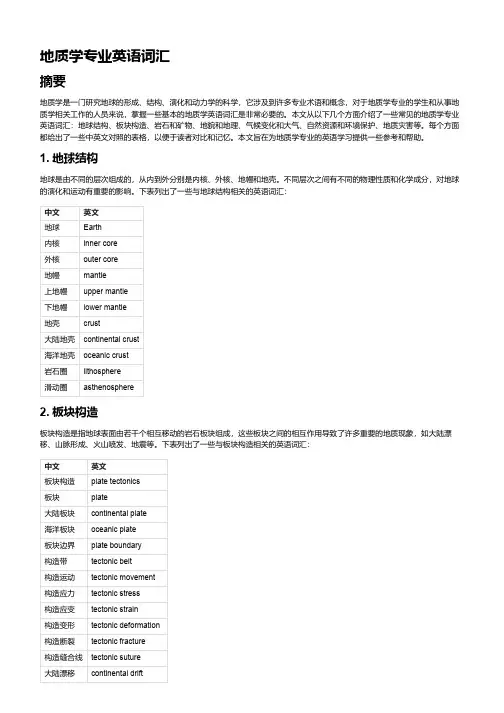
1. 地球结构地球是由不同的层次组成的,从内到外分别是内核、外核、地幔和地壳。
不同层次之间有不同的物理性质和化学成分,对地球的演化和运动有重要的影响。
下表列出了一些与地球结构相关的英语词汇:中文英文地球Earth内核inner core外核outer core地幔mantle上地幔upper mantle下地幔lower mantle地壳crust大陆地壳continental crust海洋地壳oceanic crust岩石圈lithosphere滑动圈asthenosphere2. 板块构造板块构造是指地球表面由若干个相互移动的岩石板块组成,这些板块之间的相互作用导致了许多重要的地质现象,如大陆漂移、山脉形成、火山喷发、地震等。
下表列出了一些与板块构造相关的英语词汇:中文英文板块构造plate tectonics板块plate大陆板块continental plate海洋板块oceanic plate板块边界plate boundary构造带tectonic belt构造运动tectonic movement构造应力tectonic stress构造应变tectonic strain构造变形tectonic deformation构造断裂tectonic fracture构造缝合线tectonic suture大陆漂移continental drift大陆碰撞continental collision分裂边界divergent boundary汇聚边界convergent boundary滑动边界transform boundary俯冲带subduction zone3. 岩石和矿物岩石是由一个或多个矿物组成的自然固体物质,它们是地球最主要的组成部分。
英汉GIS词汇absolute reference frame 绝对参考坐标系adjacency analysis 相邻分析adjoining sheets 邻接图幅agglomeration (制图分类中的)聚合方法aggregation 聚合;聚集altitude tinting 分层设色animated mapping 动画制图animation 动画applications package 应用软件包application program 应用程序Application Programming Interface(API) 应用程序界面Applications Program Interface 应用程序接口applications system 应用系统applied cartography 应用地图学auto-cartography 自动制图automated cartography 自动制图学automated data dictionary 自动数据字典automated data processing 自动数据处理Automated Digitizing System(ADS) 自动数字化系统automated feature recognition 自动特征识别azimuth coordinate system 方位坐标系B-spline b样条曲线B-tree 二叉树;二元树base map of topography 地形底图base map/cadastre 底图/地籍图Beijing geodetic coordinate system 1954 1954年北京坐标系block correction 区域改正block 数据块;信息组;程序块border figure 图廓数据border information 图廓注记border line 图廓线border matching 边缘匹配border 边缘;界限;边界线;邻接;图廓间cadastral survey 地籍测量cadaster 地政局;地籍图cadastral attribute 地籍特征cadastral data base 地籍数据库cadastral features 地籍特征cadastral information system 地籍信息系统cadastral information 地籍信息cadastral inventory 地籍调查cadastral layer 地籍信息层cadastral lists 地籍册cadastral management 地籍管理cadastral map 地籍图cadastral map series 地籍图册cadastral mapping 地籍制图carrier frequency(GPS) 载波频率(全球定位系统)cartographic analysis 地图分析cartographic classification 地图分类cartographic communication 地图传输cartographic data base managem ent system 地图数据库管理系统cartographic data base 地图数据层cartographic data model 地图数据模型cartographic expert system 制图专家系统cartographic generalization 制图综合cartographic projection 地图投影cartographic(al) analysis 地图分析cartography 地图制图学;地图学chorographic map 时序图choropleth map 等值区域图class interval 分级间距;分类间距class list 分类清单class 分类,分级classification rule 分类规则cluster 聚类分析compaction 压缩completeness 完整性computer-graphics technology 计算机图形技术congruent image 叠合图象contour 等高线,等值线,轮廓contouring display 分层显示cover-ID 层标识符coverage [GIS]图层data 数据data access security 数据存取安全性data accessibility 数据可达性data acquisition 数据获取data analysis 数据分析data architecture 数据结构data attribute 数据特性data base;database 数据库data capture 数据采集data catalogue 数据目录data communications 数据通信data quality 数据质量data security 数据安全性data conversion 数据转换data definition 数据定义data editing 数据编辑data element 数据要素data encoding 数据编码data entry 数据输入Data Exchange Format 数据交换格式data extraction 数据提取data file 数据文件data handling 数据处理data item 数据项data layering 数据分层data manipulation 数据操作data model 数据模型data product 数据产品data quality 数据质量data reality 数据真实性data records 数据记录data reduction 数据整理data reduction;datacompression 数据压缩data redundancy 数据冗余度data representation 数据表示data retrieval 数据查询data schema 数据模式data security 数据安全性data sensitivity 数据灵敏性data set 数据集data set quality 数据集质量data smoothing 数据平滑data snooping 数据探测法data sources 数据源data storage 数据贮存data structure conversion 数据结构转换data structure 数据结构data transfer 数据传输data transmission 数据传输data type 数据类型data updating 数据更新data vectorization 数据矢量化datum transformation 基准变换descriptive data 描述数据desktop GIS 桌面地理信息系统differential Global Positioning System;DGPS 差分全球定位系统digital cartography 数字地图制图digital correlation 数字相关digital data collection 数字数据存贮系统Digital Data Communication Message Protocol 数字化数据通讯消息协议Digital Data System 数字化数据系统digital data 数据;数字资料Digital Elevation Matrix(DEM) 数字高程矩阵digital encoding 数字编码digital exchange format 数据转换标准Digital Field Update System 数字化外业更新系统digital files synchronization 数字化文件同步化Digital Geographic Information数字化地理信息交换标准Exchange Standard;DGIWG;NATOdigital image processing 数字图象处理digital image 数字影(图)象Digital Landscape Model 数字景观模型Digital Line Graph;DLG 数字线划图digital map registration 数字地图套合digital mapping 数字测图digital map 数字地图digital mosaic 数字镶嵌digital mosaicing 数字镶嵌digital number;DN 数字值digital orthoimagery 数字正射影象digital orthoimage 数字正射影象Digital Orthophotoquads;DOQ 数字正方形正射象片图digital orthophoto 数字正射影象digital photogrammetry 数字摄影测量digital process 数字化过程digital rectification 数字纠正digital simulation 数字模拟digital surface model;DSM 数字表面模型digital tablet 数字化板Digital Terrain Model;DTM 数字地面模型Digital to Analog Converter 数/模转换器digital tracing table 数控绘图桌digital value 数字化值digital voice 数字化声音digital-analog 数字模拟digitalyzer 模数转换器digital 数字的digitization 数字化digitize maps 数字化地图digitized data 数字化数据digitized file 数字化文件digitized image 数字化影象digitized terrain data 数字化地面数据digitized video 数字影(图)象digitizer accuracy 数字化仪精度digitizer resolution 数字化仪分辨率digitizer workstation 数字化工作站digitizer 数字化仪digitizing 数字化digitizing board 数字化板digigtizing cursor 数字化鼠标digitizing edit 数字化编辑digitizing table;tablet 数字化板digitizing threshold 数字化阀值digraph 有向图disk space 磁盘空间disk storage 磁盘存储diskette 软磁盘disk 磁盘distributed architecture 分布式体系结构Distributed Computing Environment 分布式计算环境Distributed Data Processing 分布式数据处理Distributed Database ManagementSystem,DDBMS 分布式数据管理系统Distributed Database ;DDB 分布式数据库distributed processing 分布式处理Distributed Relational 分布式关系数据库结构Database Architecture(DRDA)districe coding 地区编码districting 分区(空间聚合)disturbed orbit 卫星轨道升交点docum ent file 文档文件Document Image Peocessing(DIP) 文件影象处理docum ent window 文档窗口docum ent-file icon 文档文件图标docum ent/page reader 光符识别仪器docum entation drawing 二维绘图downloadable font 可传输字符download 文件(程序)传输(从中心机到个人微机)drafting scale 绘图比例尺drafting 绘制;绘图;草拟draft 草图;草案drainage map 水系图;流域图drainage pattern 水系类型;水网类型drainage 水系;水文要素;排水设备drape 两维数据在表面叠加产生透视图draping 两维数据叠加在透视图上drawing board 绘图板drawing entities 绘图实体Drawing Exchange Format 图形交换格式drawing extents 绘图范围drawing file 绘图文件drawing grid 绘图格网drawing interchange format 绘图交换格式drawing limits 绘图限制drawing registration 绘图对齐;绘图定位drawing sizes 图面大小;图幅尺寸drawing unit 绘图单元drawing 绘图drum plotter 滚筒式绘图机drum scanner 滚筒式扫描机duobinary coding 双二进制编码DX 90 水文地理数据格式dynamic-Link Library,DLL 动态链接库E-R diagram E-R图earth gravity model 地球重利模型Earth Resources Information System;ERIS 地球资源信息系统EROS 地球资源观测系统earth satellite thematic sensing 地球卫星专题遥感earth shape;figure of the earth 地球形状Earth spheroid 地球椭球体Earth spherop 地球椭球面earth surface 地球表面earth synchronous orbit 地球同步轨道earth window 地球数据窗口Earth-centered ellipsoid 地心椭球Earth-fixed coordinate system 站心坐标系EarthResource Technology Satellite 地球资源技术卫星Earthwatch 地球监视卫星ecosystem 生态系统edge join 边缘匹配edge matching 边缘匹配edge of the format;map border 图廓Electronic Data Interchange (EDI) 电子数据交换edit 编辑;修改edit verification 编辑核实edit/display on input 输入编辑/显示edit/display on output 输出编辑/显示editing 编辑effective radius of the Earth 地球有效半径eigenvector analysis 特征向量分析eigenvector 特征向量EIS process 环境影响评价过程electric mail;e-mail 电子邮件electronic bearing 电测方位electronic chart 电子海图Electric Chart and Display 电子图形显示信息系统 Information System;SCDISelectronic chart data base;ECDB 电子海图数据库Electronic Data Collection 电子数据集合Electronic Data Interchange;EDI 电子数据交换electronic drawing tablet 电子绘图板electronic engraver 电子刻图机electronic imaging system 电子成像系统electronic line scanner 电子扫描机electronic map 电子地图electronic publishing system 电子印刷系统Embedded QUEL 内嵌式查询embedded SQL 镶嵌式查询语言emergency run 地图翻印encipher;encode;encoding 编码enclosing rectangle (最小)封闭四边形encoding code model 编码模型encoding schem e 编码方法End Of Line 文件结束标志End Of Text 行结束标志end points 文本结束标志end user participation 终端用户参与end user 终端用户ent-to-end data system 终端站间数据系统Enhanced graphics Adapter(EGA) 增强图形适配器enhanced imagery 增强图象enhanced mode 增强模式entity 实体entity classes 实体类entity classes 实体分类entity instance 实体样品entity object 实体对象entity point 实体定位点entity relationship data model 实体关系数据模型entity relationship diagram;ERD 实体关系图Entity Relationship Model;E-R Model 实体关系模型entity set model 实体集模型entity set 实体集entity subtype/supertype 实体子类型/母类型entity type 实体类型Entity-Relationship Approach E-R法entity 实体,组织,结构entropy coding 熵编码entropy 熵(平均信息量)environmental analysis 环境分析environmental assessment 环境评价environmental cadastre 环境地籍图environmental capacity 环境容量environmental data base 环境数据库environmental data/information 环境数据/信息environmental map 环境地图environmental mapping data 环境制图数据environmental overlays 环境图environmental planning 环境规划environmental quality assessment 环境质量评价environmental remote sensing 环境遥感Eclogically Sustainable Development 生态平衡的持续发展equation item 方程项European Transfer Format(ETF) 欧洲传输格式executable file 执行文件execution 执行(程序指令)extended color 扩展彩色Extended Graphics Adapter(EGA) 增强图形适配卡Extended Graphics Array 扩展图形矩阵Extensional Database 扩展数据库external attribute table 外部属性表external data storage 外部数据存储(相对于数据库) external database file 外部数据库文件external margin 外图廓external polygon 外部多边形external program 外部程序external schema 外部模式external storage 外部存储设备facilities 设施;装备facility data 设施数据facility instrument 设施设备facility map 设施图facility network 设施网络facility splice 设施接合fast Fourier transform 快速傅立叶变换feature 特征Feature and Attribute Coding Catalogue 地物与属性编码目录feature attribute table 特征属性表feature bounded 边界标识地物feature class 特征分类feature codes menu 特征码清单feature codes 特征码feature coding 特征编码feature extraction 特征提取feature identifier 特征标识符feature ID 特征标识符feature instance 特征实例feature item 特征项feature marked 有标记特征feature number 特征标识符feature selection 特征选择feature separation 特征分类feature spanned 跨区特征feature supported 支持特征feature user-ID 特征用户标识码Federal Information Processing 联邦信息处理标准 Standards(FIPS)Federal Information Processing Standards/ 联邦信息处理标准/空间数据转换标准Spatial Data Transfer Standard;FIPS/SDTS field [数据]域file [计算机]文件file activity 文件活动file attribute 文件属性file compression 文件压缩file format 文件格式file fragmentation 文件分段存储file indexing 文件管理索引file integrity 文件完整性file name extension 文件扩展名file name 文件名file protection 文件保护file server protocol 文件服务器协议file server 文件服务器file set 文件集file specification 文件说明;文件说明表file structure 文件结构file system 文件系统File Transfer Protocol 文件传输协议file transfer 文件转换file-by-file compression 文件压缩filename extension 文件后缀名fill pattern 填充模式fixed length record format 定长记录格式flag 标志;特征flair point 识别点;明显地物点flap 叠置floppy disk;floppy 软盘form line 地表形态线format conversion 格式转换format line 格式行format model 格式模型format 格式formatted model 格式化模型formatting function 格式化函数;格式编排formatting 格式化formfeed 换页;格式馈给forms interface 格式界面forms processing 表格处理fractal 分数的;分形;分数维fractional map scale 分数地图比例尺fractional scale 分数比例尺frequency band 频段;频带frequency bias 频偏frequency curve 频率曲线frequency demodulation 鉴频frequency distribution 频率分布full-resolution picture 全精度影(图)象,高分辨率影(图)象fully concatenated key 全连串码fully digital mapping 全数字化制图function library 功能库functional data base 功能数据库functional mapping 功能制图functional structure 功能结构fuzzy analysis 模糊分析fuzzy C-means 模糊聚类法fuzzy classifier method 模糊分类法fuzzy distance 模糊距离fuzzy intersection concept 模糊交叉概念fuzzy tolerance 模糊容限fuzzy 模糊的;失真的Gauss plane coordinate 高斯平面坐标Gauss-Kruger coordinate 高斯-克吕格坐标Gauss-Kruger grid 高斯-克吕格格网Gauss-Kruger map projection 高斯-克吕格地图投影Gaussian coordinate 高斯坐标gazetteer 地名录general scale 基本比例尺generic term 地理通名Geo Based Information System 基于地学的信息系统geo-analysis 地理分析geo-defined unit 地理定义单元geo-distribution 地理分布geo-politic data base 行政区划数据库geo-referenced information system 地理参考信息系统geobase system 地区系统geobased information system 地区信息系统geobase 地区库geobotanical cartography 地植物学制图geocartography 地理制图geocoded virtual map 地理编码虚拟图geocodes 地理编码geocode 地理编码geocoding system 地理编码系统geocoding 地理编码Geographer's Line 地理坐标网geographic aggregation 地理聚合Geographic Analysis and Display System(GADS) 地理分析显示系统Geographic Analysis Package(GAP) 地理分析软件geographic analysis/modeling capability 地理分析/模拟能力geographic analysis 地理分析geographic area boundaries 地理面积边界Geographic Area Code Index(GACI) 地理面积编码索引Geographic Base File(GBF) 地理基础文件Geographic Base File/Dual 地理底图基础文件/双重独立地图编码Independent Map Encoding(GBF-DIME) Geographic Base Information System(GBIS) 地理基础信息系统Geographic Base System(GBS) 地理基础系统geographic boundaries 地理边界geographic boundary data 地理边界数据geographic calibration 地理标准geographic center 地理中心geographic classification 地理分类geographic codes 地理坐标码geographic coding 地理编码geographic coordinates 地理坐标geographic coordinate 地理坐标geographic coverage 地理层geographic data base 地理数据库geographic data set 地理数据集geographic data structure 地理数据结构Geographic Database 地理数据库geographic data 地理数据geographic display system 地理显示系统geographic entity 地理实体geographic feature data 地理特征数据geographic feature 地理特征geographic graticule 地理坐标网geographic grid 地理网格geographic identifiers 地理标识符geographic indexed file 地理索引文件geographic indexes 地理索引geographic information system 地理信息系统geographic inverse 地理位置反算geographic landscape 地理景观geographic latitude 地理纬度geographic location 地理位置geographic longitude 地理经度geographic meridian 地理子午线geographic modeling 地理模拟geographic name 地理名称geographic net 地理坐标格网geographic numbering system 地理编号系统geographic object 地理对象geographic pole 地极geographic position 地理位置geographic reference system 地理参考系统geographic reference 地理参考geographic referencing 地理参考过程geographic standardization 地理标准化geographic survey 地理测量geographic value 地理坐标值geographical coordinate 地理坐标geographical data base 地理数据库geographical general name 地理通名geographical map 地理图geographical mile 地理海哩geographical name index 地名索引transcription;geographical 地名注音法name transliterationgeographical name;place name 地名geographical network 地理格网geographical pole 地极geographical position 地理位置geographical reference system 地理坐标参考系geographical viewing distance 地理视距geographical zones 地理带geographical-exploration traverse 地理勘测路线geographical 地理的geographics limits 细线;内图廓线geographic 地理的;地理学的geography 地理学Geomatics (加拿大)地球信息学geometric rectification 几何校正geometric registration 几何配准geomorphic map 地貌类型图geomorphological mapping 地貌制图geomorphological map地貌图geomorphology 地貌学geoprocessing application 地理处理应用geoprocessing approach 地理处理方法geoprocessing functions 地理处理函数geoprocessing modeling 地理处理模拟geoprocessing operations 地理处理操作geoprocessing productivity 地理处理率geoprocessing system 地理处理系统geoprocessing virtual map system 地理处理虚拟图系统Geoprocessing(GP) 地理处理过程geoprocessor 地理处理器GEOREF coordinate system 世界地理坐标参考系GEOREF grid 世界地理坐标参考网格georeference system 地理坐标参考系georeference 地理坐标参考georeferenced 地理坐标参考的georeferencing 地理坐标参考过程GEOREF 世界地理坐标参考系georelational model 地理相关模型geosphere 地理圈geostatistics 地理统计GIS/LIS 地理信息系统/土地信息系统Global Environm ental Monitoring System(UNEP) 全球环境监测系统(联合国环境项目)global land information system(GLIS) 全球土地信息系统Global Positioning System(GPS) 全球定位系统global positioning 全球定位global rediation 总辐射global satellite system 全球卫星系统Global T elecommunications System 全球远程通讯系统global 全球的graphic compose 图形合成graphic data base file 图形数据库文件graphic data base 图形数据库graphic data concept 图形数据概念graphic illustration 图解说明;图解例证graphic input procedure 图形输入法graphic input unit 图形输入设备Graphic Interchange Format 图形交换格式graphic interpolation 图解内插法graphic limits 图形边界graphic manipulation 图形维护graphic map features 图示地图特征graphic map manipulation 图示地图操作graphic map scale 图解地图比例尺graphic mapping control point 图解图根点graphic menu 图示菜单graphic modes 图示模式graphic object 图形对象graphic output unit 图形输出设备graphic overlay 图形叠加graphic plane 图示面graphic primitive 图形元素graphic presentation 图形显示graphic production 图形生成graphic product 图形产品graphic rectification 图形校正graphic representation 图形表示graphic scale 图解比例尺graphic sign 图形记号graphic superimposition 图形叠加graphic symbol 图形符号graphic symbols/symbology 图形符号/符号表示graphic system components 图形系统组成graphic tablet 图形数字化板graphic terminal 图形终端graphic text string 图形文本串graphic trace 图形跟踪graphic variable 图形变量graphical screen interface 图形屏幕界面graphical user interface(GUI) 图形用户界面graphics accelerator 图形加速卡graphics cursor 图形光标graphics display units 图形显示单元graphics inquiry 图形查询graphics languages 图形语言graphics mode 图形模式graphics page 图形页Graphics Performance Characterization(GPC) 图形工作特性graphics resolution 图形分辨率graphics screen 图形屏幕界面graphics software 图形软件graphics tablet 图形数字化板graphics 图形graphic 图形的;图示的graph 图;图形graticule 格网graticule 十字丝;地理坐标网grating 光栅grid 格网grid amplitude 格网幅度grid azimuth 坐标方位角grid bearing 坐标方位角grid cell 格网元素;网眼grid cell compositing 网眼组成grid cell data structure 网眼数据结构grid cell data 网眼数据结构grid cell lattice 三维网眼格数据结构grid cell map-record format 网眼地图记录格式grid cell map 网眼地图grid cell modeling 网眼模拟grid cell search 网眼搜寻grid convergence 坐标纵线收敛角grid coordinate system 格网坐标系grid coordinates 格网坐标系grid data 格网数据grid declination 格网真北偏角grid equator 格网赤道grid factor 格网因子grid format 格网格式grid interval 网格间距grid inverse 网格反算grid length 坐标网距grid lines/codes 格网线/码grid magnetic angle 格网磁偏角grid map 格网地图grid meridian 坐标网纵线grid method 格网法grid of neighboring zone 邻带方里网grid origin 坐标格网原点grid structure 网格结构grid system 格网系统grid tick 格网标记grid variation 格网磁偏角grid zone 坐标带grid 栅格,格网;坐标网grid-point method 网点板法grid/raster data 格网/栅格数据gridded data 格网数据gridiron layout 格网平面图gridiron pattern 格网图形gridsystem 直角坐标格网grips 数据转换程序halftone screen 半色调屏幕header file 头文件header label 头标header line 标题行header record 首记录header 标题hextree 分级图象数据模型hidden attribute 隐含属性hidden file 隐含文件hidden line removal 隐线消除hidden surfaces 隐面hidden variable 隐含变量hierarchical data base 分级数据库hierarchical data 分级数据hierarchical data model 层次数据模型hierarchical data structure 分级数据结构hierarchical database 分层数据库hierarchical districts 层次分区hierarchical file structure 分级文件结构hierarchical file system 分级文件系统hierarchical model 分级模型hierarchical organization 等级结构hierarchical relationship 分级关系式(数据文件结构)hierarchical sequence 层次序列hierarchical spatial relationship 分级空间关系hierarchical storage 分级存储hierarchical structure 分级结构hierarchical 分级的;层次的hierarchization 分级High Level Data Link Control 高级数据连接控制High Memory Area 高位地址内存区histogram 直方图;柱状图;频率图history 命令记录Huffman code 霍夫编码hull TIN表面Human Computer Interaction 人机交互Human Computer Interface 人机界面hypertext 电子文本;超级文本I channel 同相信道;I通路I notation parameter 整数记号参数I-beam I指针I/O addresses 输入/输出地址I/O Character Recognition(I/O CR) 输入/输出字符识别I/O error 输入/输出错误I/O port 输入/输出端口image coding 图象编码image compression 影(图)象压缩image contrast 影象反差image coordinate 影象坐标image correlation 影象相关image data base 影象数据库image data collection 图象数据收集image data compaction 图象数据压缩image data retrieval 图象数据检索image data storage 图象数据存储image data 影(图)象数据image definition 影象清晰度(分辨力)image degradation 影(图)象退化;影(图)象衰减image description 影象描绘image digitization 图象数字化image displacement 影象位移image distortion 影(图)象失真image integrator 图象综合image intensifier 影(图)象增强器;变象管;象亮化器image intensity 图象强度image interpretation 影象判读image magnification 影(图)象放大image matching 影象匹配image processing rectification 图象处理校正复原 and restorationimage processing 图象处理校正复原image ray 象点投影线image recognition 影(图)象识别image reconstruction 影(图)象重建image reconstructor 影象再现装置image registration 图象配准image representation 影(图)象显示;影(图)象再现image resolution;ground resolution 影象分辨力image scale 影象比例尺image size 影(图)象尺寸;影(图)象范围image space coordinate system 象空间坐标系image space 象空间image stack 影(图)象栈image transform 影(图)象变换image transformation 图象变换image translator 影(图)象转换器image;imagery 影象image 象,象片;影象,图象;镜象图形imagery feature 影象特征index to Names 地名索引indexed sequential file 顺序索引文件indexed 索引化的indexing 索引;加下标;变址index 指标;指数;索引informatics 信息学information area 信息区information bit 信息位information center 信息中心information collection 信息采集information content 信息量information explosion 信息爆炸information extraction 信息提取information float 信息浮动information format 信息格式information management 信息管理information network 信息网information overlays 信息叠加information rate 信息传输速率Information requirement(IR) 请求信息information revolution 信息革命information science 信息科学information system 信息系统information technology(IT) 信息技术information theory 信息论information window 信息窗口infowmation 信息input area 输入区input data 输入数据input device 输入设备input image(inimage) 输入影(图)象input/output analysis 输入/输出分析input/outpu model 输入/输出模型Input/Output(I/O) 输入/输出input 输入inquiry 查询insert 插入;嵌入integrated data base 集成数据库integrated data layer 集成数据层Integrated Geographical Information System 集成化地理信息系统integrated GIS/technologies 综合地理信息系统/技术integrated information system 综合信息系统integrated spatial system 综合空间信息系统integrated system 综合系统interactive 交互式interactive digitizing 人机交互数字化interactive display 人机交互显示interactive drafting 交互式绘图interactive editing 交互式编辑Interactive Graphics and Retrieval System 交互图形与恢复系统Interactive Graphics Design System 交互式图形设计系统Interactive Graphics System/Interactive 交互式制图系统/交互式制图子系统Graphics Subsystem;IGS/IGSSinteractive graphics 交互式制图interactive image processing system 人机对话影(图)象处理系统interactive mode 交互式模式Interactive Multimedia 交互式多媒体interactive processing mode 人机交互模式interactive processing 人机交互处理interactive processing 交互式处理interactive restoration 人机对话复原Interactive Surface Modeling 交互式地表建摸interactive topology 交互式拓扑Interactive Volume Modeling 交互式立体模型intercell plot 单元间图(或文件)interchange format 交换格式interchange modeling 交换模拟interchange model交换模型internal data model 内部数据模型internal data structure 内部数据结构(只在处理过程中保持的)internal database file 内部数据库文件interrecord data structures 交互记录的数据结构inverse fast Fourier transform 快速傅立叶变换isoline 等值线isolith 等厚度线isolong 等经度改正线isomagnetic chart 等磁力线图isometric coordinate 等量坐标isometric design 等角投影isometric latitued 等量纬度isometric map projection 等量地图投影isometric mapping 等量制图isoperimetric map projection 等量地图投影isoplane 等平面isopleth mapping 等值线制图isopleth map 等值线图isoplethic mapping 等值线制图isoplethic map 等值线图isopleth 等值线key 关键字key attributes 关键属性key bed 标准层key entry 键盘输入key feedback area 码反馈区key field 关键字段key file 关键文件key horizon 标志层key identifiers 关键标识符key map 索引图;总图key pad 键座key value dictionary 关键值索引key variable indexing 关键变量索引keyboard buffer 键盘缓冲keyboard equivalent key 键盘等价命令键keyboard shortcut 键盘快捷命令keyboard 键盘Land evaluation 土地评价Land Information System(LIS) 土地信息系统Land Information Technology(LIT) 土地信息技术land types 土地类型land unit 土地单元land use 土地利用landform 地表形态landscape drawings 景观绘图landscape map 景观地图layer file 层文件layer index 图层索引layer index 层索引layer system 分层设色法layer-tinted map 分层设色地图layered style map 分层设色地图layered style 分层设色表示法layering 分层;层化layers 层次layer 层layover 覆盖;遮蔽(雷达影像)Leaf Area Index 叶区域索引leaf level 叶层次league 里格leaking polygon 未闭合多边形legend 图例lettering 地图注记lineage 数据说明line element 线状要素line feature 线状特征line follower 线跟踪器(量测转换边界)line generalization 趋势线概化line graph 线状图line in polygon calculation 多边形内线判断计算line in polygon retrieval 多边形内线判断查询line intersection 线段交叉line map 线画图line of nodes 交轨线line symbologics 线状符号表达法line symbol线状符号local database 局域数据库local datum 局部定标数据logical block 逻辑块logical channel number 逻辑通道号码logical consistency 逻辑一致性logical contouring 逻辑恒直线logical data base(LDB) 逻辑数据库logical data model 逻辑数据模型logical data structure 逻辑数据结构logical decision 逻辑判定logical design 逻辑设计logical exclusive operation of image 影象逻辑异运算logical expression 逻辑表达logical links 逻辑连接logical mounting 逻辑安装logical name 逻辑名字logical operation 逻辑运算logical operator 逻辑运算符logical order 逻辑指令logical overlap 逻辑重叠logical record 逻辑记录logical security 逻辑安全性logical selection 逻辑选择logical storage structure 逻辑存储结构logical unit 逻辑单元logic 逻辑login (=logon)注册lot and block 地块与街段lot dimensions 地块尺寸lot line 地块边界lot of record 地块记录lot 地块LPT port 并行口LU pooling 逻辑单元合并machine bias 机器偏差machine code 机器码machine encoding 机器编码machine language 机器语言machine processable 机器可处理的man-machine interface 人机接口manager access 管理者存取manual digitizer 手扶数字化器manual digitizing 人工数字化manual encoding 人工编码manual link 人工连接manual map enhancement 人工地图增强manuscript map 原图;稿图manuscript 原图many-to-one relate 多对一关系map accuracy(absolute) 绝对地图精度map accuracy(relative) 相对地图精度map accuracy level 地图精度水平map accuracy specifications 地图精度说明map accuracy standards 地图精度标准map adjustment 地图接边;图幅接边map algebra 地图代数Map and Chart Data Interchange地图与图表间数据交换map appearance 地图整饰map average 地形特征地图map black clouds 地图数据密集区map border 图廓map chart 作战海图map clarity 地图清晰性map closure 地图闭合map code (1)地图代码;(2)变换码,印象码map collar data 地图边缘数据map color atlas 地图色谱map compilation 地图编绘map complexity 地图复杂性map composition 地图编制map computerization 地图计算机化map coverage 地图层map data base 地图数据库map data retrieval 地图数据查询map data structure 地图数据结构map data 地图数据map decoration 地图整饰map deformation 地图变形map description 地图描述map digitization 地图数字化map digitizing 地图数字化map directory 地图目录map display 地图显示map distortion 地图畸变map distribution 地图供应map edge 图幅边缘map editing 地图编辑map extent 地图范围map face 图幅尺寸;图幅面积map feature 地图特征map files 地图文件map generalization 地图综合map graphics to text data linkage 图形-文本数据连接map graphics 图形-文本数据连接map grid 地图格网map information 地图信息map interpretation 地图判读map join 图幅连接map layer 图层map layout 图面配置map legibility 地图易读性map limits 图范围map linkage 图连接map load 地图负载量map making 制图map matching guidance 地图匹配导航map matching 地图匹配map measure 量图轨map miles 地图英里坐标系统map model system 地图模型系统map nadir 图面底点map name 地图名map of neotectonic strength 图上量算map origin 图坐标原点map overlay analysis 地图叠置分析map overlay modeling analysis 地图叠置模拟分析map overlay 地图叠置map parallel 图横线map perception 地图感受map plotting 填图map point 图上定位点;图面点map positional file 地图叠置文件map position 地图定位map projection system 地图投影系统map projection transformation 地图投影转换map projection 地图投影map projector 地图投影仪map quadrangle/map quad 地图标准图幅map query 地图查询map reading 读图map registration 地图对齐map representation file 地图表示文件map resolution 地图分辨率map revision 地图更新map scale number 地图比例尺数map scale 地图比例尺map scaling 地图比例变换map section 图区map series 系列地图map set miles 图集英里比例尺map sheet manipulation 图幅操作map sheet 图幅map shift 图幅移位map sliver 地图细小多边形map specifications 地图规范map standards 地图标准map substitute 临时版地图map symbolism 地图符号体系map symbol 地图符号map systematic errors 地图系统误差map test 地图检测map theme 地图专题map title 图名。
AbsoluteX,Y X,Y轴的绝对坐标Abstract 抽象,抽象类Access Microsoft公司的一种数据库软件产品Activate 激活,使某数据框架进入操作状态Alias 字段假名Aligned,Alignment 字符注记对齐Allocation 空间配置,邻近分配Animation 动画Annotation 地图注记、注记要素Application 应用,应用单元Attribute 属性Attribute Table 属性表BBackground 地图显示、制图的背景Band 影响波段Barrier 网络障碍Basic Tool Bar 基本工具条BMP 一种通用的图像数据格式Border 地图外框线、图廓线Brightness 图像显示亮度Buffer 邻近、缓冲Buffer Zone 邻近区、缓冲区CCAD(Computer Aided Design and Drafting) 计算机辅助设计与绘图CAD Feature Dataset CAD数据集Callout 引线式注记Catalog 目录表、目录窗口Categories 定性分类Cell 栅格单元Cell Size 栅格单元大小Charts 统计图Class 类Classification 分类Clip 裁剪、一种叠合处理方式CoClass 组件类Closest Facility 最近设施Cluster Tolerance 线簇容差Color Ramp 色彩过渡表Commands 命令Connectivity 网络连接Contract 图像显示的对比度Contour 等值线、等高线Control Point 校正坐标用的控制点Coordinate System 坐标系、坐标系统Copy Parallel 平行复制Cost Distance 考虑成本距离Cost Weighted Distance 以成本为权重的距离Coverage ArcInfo的一种空间数据格式Customize 自定义Cut/Fill 填挖方DDangle Node 悬结点Data Frame 数据框架Data Frame Properties 数据框架特征设置Data Source 数据源Data View 数据视图Dataset 数据集dBase 一种数据库管理软件的名称DBF,dbf 一种属性数据库的文件格式Delta X,Y X,Y轴的偏移坐标Density 密度DGN 一种CAD数据文件格式Digitizing 数字化,矢量要素输入计算机Dimension 相对距离注记Dirty Area 存在违反拓扑规则要素的范围Display Units 地图显示单位Dissove 多边形归并、融合Drawing Tool Bar 绘图工具条Drop Shadow 使制图工具具有阴影效果Dot Density 点密度地图DXF CAD数据交换格式DWG CAD文件格式EEdge 网络边线Edge Match 地图接边Element 图形元素Elevation 高程End 网络线段、网络边线的端点End Node 线要素的终点、终结点Endpoint 同End NodeEqual Interval 等间距分类Extend 线要素延伸Extent 数据的空间范围Extensions 扩展、软件的扩展模块FFacility 设施Feature 要素、地理要素Feature Attribute Table 要素属性表Feature Class 要素类Feature Dataset 要素数据集FGDC(Federal Geographic DataCommittee) 美国联邦地理数据委员会Field 属性表的字段Fill Symbol 填充符号Fillet 加圆角From Point 网络线段的起点,起始端点GGeodatabase 地理数据库、空间数据库Geographic Coordinate System 地理坐标系Geometric Network 几何网络Geoprocessing 地学处理、空间处理Graduated Fill Symbol 渐变填充符号Graduated Colors 颜色渐变图Graduated Symbol 符号渐变图Graph 统计图Graphic 图形Graphic Element 图形要素Graphic Text 图形注记Grid 格网HHistogram 直方图Hyperlink 超链接IIcon 图标Identify 要素识别、显示要素的属性Image 影像、图像Image Adjust 影像配准Incident 网络分析中的事件Index 索引INFO ArcInfo的属性数据库,和Coverage对应Impedance 网络阻抗Integer 整型数据Interpolate,Interpolation 插值、空间插值ISO 国际标准化组织Item 数据项JJoin 连接表和表合并Junction 网络中线段端点和端点的交汇处JPEG 一种通用图像数据格式LLabel 图例标注Latitude 纬度、纬线Layer 地图图层、专题图层Layer Properties 图层特征Layer File 图层设置文件Layout 地图布局Legend 图例Line Symbol 线装要素符号Linear Reference 线性参考Longitude 经度、经线MMacro 宏命令Map Document 地图文档Map Element 地图制图元素Map Topology 地图拓扑Match to symbol in a style 匹配某个格式文件中的符号Merge 要素合并Metadata 元数据Multi Band 多波段影像Multi-part Feature 组合要素,一个要素由多个部分合并而成Multiple Attributes 多重属性NNatural Breaks 自然区间分类Neatline 图廓线Network 网络Network Dataset 网络数据集Normalization 归一化OOverlay 叠合、叠置Overshoot 线过长OMDs 对象模型图OLE 对象嵌入和链接PPan 图形平移Parallel 平行Perpendicular 垂线Precision 精度Proportional Symbols 比例分配图Proximity 邻近、相邻Pseduo Node 伪结点Pyramids 金字塔数据结构、数据索引RReflection 偏转角度Residual Error 残差,坐标转换后控制点坐标和参照点坐标的差距RMS 坐标转换残差Rubber Sheeting 橡皮拉伸、坐标拉伸TThiessen 泰森多边形Thumbnail 缩略图Tolerance 容差Trim 线要素剪切。
Words and expressionsUnit 1geoscience地球科学informatics信息学,情报学monitor监控,监测,监视,控制,追踪,监控器appreciate增值,涨价,赏识,鉴赏,感激dwindle缩小Iso International standardization organization国际标准化组织explicit清楚的,外在的,直率的,(租金等)直接付款的hydrographic与水道测量有关的,与水文地理有关的hydrographic survey海道测量,水道测量practitioner从业者,开业者expertise专门技术,专家的意见flexibility适应性,机动性,挠性Incorporation结合,合并;形成法人组织,组成公司(或社团) coherent一致的,连贯的demise死亡,让位,禅让ut让渡,遗赠,转让blur把(界线,视线等)弄得模糊不清,涂污,污损(名誉等),弄污visualization可视化,清楚地呈现pertaining有关系的,附属…的,为…固有的(to)Imagery肖像(总称),雕刻影像plotting标图,测绘illustrative 说明性的,例证性的entity实体digitize [计]将资料数字化registration注册,报到,登记forestry林产,森林地,林学geology地质学,地质概况geographical地理学的,地理的infrastructure基础下部组织,下部构造navigation导航,航海,航空,领航,航行quarterly一年四次的,每季的evolve (使)发展,(使)进展,(使)进化cadastre地籍簿,地籍,地籍图cadastral surveying地籍测量sensor传感器manipulate(熟练地)操作,使用(机器等),操纵(人或市价、市场),利用state - of - the - art 先进的,一流的geophysics地球物理学oceanography 海洋学retrieval检索,恢复,修补,重获embrace拥抱,互相|拥抱,包含,收买,信奉ti拥抱n.拥抱geomatics测绘学geodesy大地测量学surveying and mapping测绘photogrammetry摄影测量学remote sensing(RS)遥感global positioning system(GPS)全球定位系统atellite positioning卫星定位geographic information systems(GIS)地理信息系统land management土地管理computer graphics计算机图形学Unit 2artiticial人造的,假的,非原产地的analog类似物,相似体chart图表,海图dimensional空间的monument纪念碑permanent monument永久标石monumentation埋石fieldwork野外工作,实地调查,野外作业category种类,类别,[逻]范畴permanent永久的,持久的theodolite[测]经纬仪prerequisite先决条件spheroid球状体,回转椭圆体allowance容许误差,容差,容许量diameter直径equator赤道,赤道线atitude纬度,范围;(用复数)地区longitude经度,经线经度meridian子午线,正午,顶点,全盛时期ad.子午线的,正午的prime meridian本初子午线,木初子午圈线northing北距(向北航行的距离),北进,北航easting东西距,朝东方;东行航程gravity重力,地心引力gravity field重力场curvature曲率,弯曲plumb铅锤,铅弹ad.垂直的t使垂直,探测plumb line铅垂线trigonometry 三角法plane trigonometry平面三角algebra代数学analytical解枥的,分析的analytical geometry解析几chord弦,弦长triangle三角形,三人一组,三角关系spherical球形的,球的sophisticate弄复杂,篡改;使变得世故入sophistication复杂;强词夺理,诡辩geoid [地]大地水准面trench沟渠,堑壕,管沟,电缆沟,战壕Atlantic ocean大西洋Pacific ocean太平洋tangent相切的,切线的n.切线,[数]正切backsight后视foresight前视;远见,深谋远虑refraction折光,折射geodetic surveying大地测量,大地测量学plane surveying平面测量,平面测量学control survey控制测量horizontal survey水平测量,平面测量vertical survey高程测量,垂直测量地形测量topographic surveydetail survey碎部测量land survey( property survey, boundary survey, cadastral survey)地测量,地籍测量route survey路线测量pipe survey管道测量city survey城市测量hydrographic survey水道测量marine survey海洋测量mine survey矿山测量geological survey地质测量Unit 3fundamental基本原则,基本原理Euclidean space欧几里得空间odometer(汽车等的)里程表,自动计在仪(美vehicle交通工具,车辆,媒介物,传达手段revolution旋转,革命circumference 圆周,周围invar铟瓦;不胀钢nickel镍,镍币,(美国和加拿大的)五分镍币alloy合金coefficient系数thermal热的,热量的tacheometry 测视距测量stadia视距,视距仪器ntercept截取,中途阻止telescope望远镜multiply乘,增加,繁殖nominal 名义上的,有名无实的,名字的,[语]名词性的manufacturer制造业者,厂商/consequence结果[逻]推理,推论,因果关系,重要的地位topographic地势的,地形学上的resultant作为结果而发生的,合成的terrain地形electromagnetic电磁的visibility 可见度,能见度,可见性,显著,明显度infrared红外线的n.红外线airborne 空气传播的,空降的,空运的particle粒子,点,极小量,微粒,质点,小品词,语气modulated已凋整[制]的,被调的distance measurement 距离测量precise ranging精密测距pacing步测,定步distance measuring instrument, rangefinder测距仪EDM( electronic distance measurement)电子测距仪geodimeter光速测距仪,光电测electromagnetic distance measuring instrument电磁波测距仪electro- optical distance measuring instrument光电测距仪long - range EDM instrument远程电子测距infrared EDM instrument红外测距仪laser distance measuring instrument, laser ranger激光测距仪microwave distance measuring instrument微波测距仪satellite laser ranger卫星激光测距仪two- color laser ranger双色激光测距仪distance- measuring error测距误差fixed error固定误差proportional error比例误差sighting distance视距multiplication constant乘常数ddition constant加常数stadia multiplication constant视距乘常数stadia addition constant视距加常数standard field of length长度标准检定场/nominal accuracy标称精度stadia hair视距丝,视距线stadia interval视距间隔Unit 3perpendicular 垂直的,正交的Intersect横断(直线)相交,交又projection投影,投射,投影图,地图投影,规划zenith天顶,顶点,顶峰,最高点celestial天上的celestial sphere天球radius半径,范围,辐射光线,有效航程,范围,界线clinometer测角器,倾斜仪sextant六分仪compass罗盘,指南针,圆规protractor量角器clockwise顺时针方向的counterclockwise反时针方向的sexagesimal六十的,六十进位的sexagesimal systen六十分制commence开始,着手bisect切成两份,对(截)开clamp夹子,夹具,夹钳encoder编码器,译码器spindle轴,杆,心轴;锭子,纺锤crystal结晶状的n.水晶,水晶饰品,结晶,晶体liquid crystal displays(LCDs)液晶显示diode二极管lght- emitting diode displays(LEDs)发光二极管显示pendulum钟摆,摇锤compensator补偿器provision供应,(一批)供应品,预备,防备,规定indexing标定指数initialize初始化azimuth方位,方位角bearing方向,方位quadrant象限四分仪horizontal angle水平角vertical angle垂直角depression angle俯角,俯视角zenith distance天顶距elevation angle高度角horizontal circle水平刻度盘vertical circle垂直度盘true north真北geodetic azimuth大地方位角grid bearing坐标方位角gyro azimuth陀螺方位角magnetic azimuth磁方位角method by series, method of direction observation方向观测法method in all combinations全组合测角法Unit 20Us. Department of defense(DOD)美国国防部castellation[天]星座,星群nsure确保,给…保险drag拖拉v拖,拖曳atmospheric drag大气阻力sun- seeking太阳定向panel面板,仪表板,全体陪审员solar panel太阳能电池板nicad镍镉蓄电池nicad battery镍镉蓄电池Colorado美国科罗拉多州(位于美国西部)Hawaii夏威夷,夏威夷岛Ascension阿森松(南大西洋岛屿)Kwajalein夸贾林环礁(位于太平洋西部)reconnaissance勘测,侦察,搜索missile导弹,发射物missile guidance导弹制导pseudorange伪距synchronize同步synchronized同步的GPS( global positioning system)全球定位系统space segment空间部分control segment控制部分user segment用户部分GPS receiver GPS接收机gps constellation gps星座master control station主控站monitor station监控站atomic clock原子钟clock error钟差broadcast ephemeris广播星历precise ephemeris精密星历Coarse acquisition codeprecise code精码pseudorange伪距ionospheric delay电离层延迟tropospheric delay对流层延迟multipath effect多路径效应Selective availability(SA)选择可用性reference receiver基准接收机roving receiver流动接收机receiver antenna接收机天线real- time kinematic(RTK)实时动态定位differential GPS(DGPS)差分GPSdifferential correction差分改正real- time differential correction实时差分改正post - processed differential correction后处理差分改正Unit 23acronym 只取首字母的缩写词distinguish 区别,辨别attribute属性,品质,特征.加于,归结于peel剥,削,剥落supercomputer[计]超型计算机hook钩住,沉迷,上瘾digitizer 数字转换器cartographe地图制作者,制图师,制图员administrator管理员,管理程序implementation执行coordinator协调者,同等的人或物raster[物]光栅vector向量,矢量,带菌者aircraft航行器census人口普查demographic人口统计学的yearbook年鉴ecosystem生态系统overlay覆盖,覆盖图buffering缓冲(作用),减震,隔离Unit 28exemplify例证,例示illumination照明,阐明,启发geothermal地热的,地温的,地热(或地温)产生的photon光子cosmic宇宙的cosmic ra宇宙射线gamma 射线thereon在其上,在那上面,…之后立即moisture湿度,湿气,潮湿irradiance发光,光辉penetrate穿透,渗透,弥漫electron电子molecular[化]分子的,由分子组成的emittance发射度,[热]辐射本领incidence人射,落下的方式,影响范围spacecraft太空船backscatter漫反射,反向散射体,反散射synthetic合成的,人造的,综合的aperture孔,穴,缝隙,(照相机,望远镜等的)光圈,孔径synthetic aperture radar(SAR)合成孔径雷达multispectral多谱线的,多谱段的spectroradiometer[物]分光辐射计side - looking 侧视的remote sensor遥测传感器,遥感器electromagnetic spectrum电磁波频谱,电磁波谱,电磁光谱transmittance传播absorptance吸收reflectance反射electromagnetic radiation电磁辐射thermal infrared detector热红外探测器passive remote sensing被动式遥感active remote sensing主动式遥感side- looking airborne radar(SLAR)机载侧视雷达;侧视雷达active microwave sensors主动微波遥感传感器passive microwave sensing被动微波遥感spectroradiometer分光辐射计radiometer辐射计scatterometer散射计scatterometry 散射测量。
GIS基本术语编码(Encoding)将信息分类的结果用一种易于被计算机和人识别的符号体系表示出来的过程,是人们统一认识、统一观点、相互交换信息的一种技术手段。
编码的直接产物是代码。
标准化(standardization)在经济、技术、科学及管理等社会实践中,对重复性事物和概念通过制定、发布和实施标准,达到统一,以获得最佳秩序和社会效益。
一般说来,包括制定、发布与实施标准的过程。
标准化审查(Standardization Examination)由标准化管理机构组织有关专家或专业技术人员,依据有关标准、规范、文件的标准化要求,对信息系统建设的各个方面进行分析、论证、审查的过程。
标准体系(Standard system)一定范围内的标准、办法、规定等按其内在联系形成的科学的有机整体。
标准体系表(Digrams of Standard System)一定范围的标准体系内的标准,按照一定形式排列起来的图表。
它是标准体系的一种直观表现形式,其组成单元是标准。
标识码(Identification Code)在要素分类的基础上,用以对某一类数据中某个实体进行唯一标识的代码。
它便于按实体进行存贮或对实体进行逐个查询和检索,以弥补分类码的不足。
城市地理信息(Urban Geographic lnformation)城市地理信息是城市中一切与地理分布有关的各种地理要素图形信息、属性信息及其相互间空间关系信息的总称。
城市地理信息系统(Urban Geographic lnformation System)简称“UGIS”。
它是地理信息系统的一个分支,是一种运用计算机硬、软件及网络技术,实现对城市各种空间和非空间数据的输入、存贮、查询、检索、处理、分析、显示、更新和提供应用,以处理城市各种空间实体及其关系为主的技术系统。
它是城市基础设施之一,也是一种城市现代化管理、规划和科学决策的先进工具。
城市基础地理信息(Urban FundamentaI Geographic lnformation)城市基础地理信息是指城市最基本的地理信息,包括各种平面和高程控制点、建筑物、道路、水系、境界、地形、植被、地名及某些属性信息等,用于表示城市基本面貌并作为各种专题信息空间定位的载体。
开采沉陷观测 mining subsidence observation开采沉陷图 map of mining subsidence开窗 windowing勘测设计阶段测量 survey in reconnaissance and design stage 勘探基线 prospecting baseline勘探网测设 prospecting network layout勘探线测量 prospecting line survey勘探线剖面图 prospecting line profile map康索尔海图 consol chart康索尔海图 consol chart抗差估计,*稳健估计 robust estimation考古摄影测量 archaeological photogrammetry克拉索夫斯基椭球 krasovsky ellipsoid克莱罗定理 clairaut theorem克莱罗定理 clairaut theorem刻绘 scribing刻图仪 scriber坑道平面图 adit planimetric坑探工程测量 adit prospecting engineering survey空基系统 space-based system空间大地测量学 space geodesy空间改正 free-air correction空间后方交会 space resection空间前方交会 space intersection空间试验室 spacelab空间数据管理系统 spatial database management system空间数据基础设施 sdi空间数据基础设施 spatial data infrastructure空间数据转换 spatial data transfer空间信息可视化 visualization of spatial information空间异常 free-air anomaly空中导线测量 aerophotogonometry空中三角测量 aerotriangulation空中水准测量 aeroleveling控制测量 control survey控制测量 control survey控制点 control point控制点 control point库容测量 reservoir storage survey跨河水准测量 river-crossing leveling块状图 block diagram快门 shutter矿产图 map of mineral deposits矿场平面图 mining yard plan矿区控制测量 control survey of mining area矿区控制测量 control survey of mining area矿山测量 mine survey矿山测量交换图 exchanging documents of mining survey 矿山测量图 mining map矿山测量学 mine surveying矿山经纬仪 mining theodolite矿体几何[学] mineral deposits geometry矿体几何制图 geometrisation of ore body框标 fiducial mark框幅摄影机 frame camera拉普拉斯点 laplace point拉普拉斯方位角 laplace azimuth兰勃特投影 lambert projection蓝底图 blue key浪花 breaker勒夫数 love's number雷达测高仪 radar altimeter雷达覆盖区 radar overlay雷达应答器 radar responder雷达指向标 radar ramark类别视觉感受 perceptual groupings类型地图 typal map离心力 centrifugal force离心力 centrifugal force离心力位 potential of centrifugal force礼炮号航天站 salyut space station理论地图学 theoretical cartography理论最低低潮面 lowest normal low water理论最高潮面 highest normal high water历史地图 historic map历元平极 mean pole of the epoch立标 beacon立井导入高程测量 induction height survey through shaft 立井定向测量 shaft orientation survey立井激光指向[法] laser guide of vertical shaft立体测图仪 stereoplotter立体地图 relief map立体观测 stereoscopic observation立体观测模型 stereoscopic model立体镜 stereoscope立体判读仪 stereointerpretoscope立体摄影测量 stereophotogrammetry立体摄影机 stereocamera立体摄影机 stereometric camera立体视觉 stereoscopic vision立体像对 stereopair立体坐标量测量 stereocomparator粒子加速器测量 particle accelerator survey 连接点 tie point连续调 continuous tone连续调 continuous tone连续对比 successive contrast连续方式 continuous mode连续方式 continuous mode连续减光板 continuous attenuator连续减光板 continuous attenuator帘幕式快门,*焦面快门 curtain shutter帘幕式快门,*焦面快门 curtain shutter帘幕式快门,*焦面快门 focal plane shutter 联测比对 comparison survey联测比对 comparison survey联合平差 combined adjustment联合平差 combined adjustment联盟号宇宙飞船 soyuz spacecraft联系测量 connection survey联系测量 connection survey联系三角形法 connection triangle method 联系三角形法 connection triangle method 联系数 correlate联系数 correlate亮度 lightness量测摄影机 metric camera量底法 quantity base method量化 quantization量化 quantizing裂缝观测 fissure observation邻带方里网 grid of neighboring zone邻图拼接比对 comparison with adjacent chart邻图拼接比对 comparison with adjacent chart邻元法 neighborhood method邻元法 neighborhood method林业测量 forest survey林业基本图 forest basic map零[位]线改正 correction of zero line零[位]线改正 correction of zero line零漂改正 correction of zero drift零漂改正 correction of zero drift零相位效应 zero-phase effect领海基线测量 territorial sea baseline survey六分仪 sextant鲁洛夫斯太阳棱镜 roelofs solar prism陆地卫星 landsat滤光片 filter旅游地图 tourist map略最低低潮面,*印度大潮低潮面 indian spring low water 略最低低潮面,*印度大潮低潮面 lower low water罗经[校正]标 compass adjustment beacon罗经[校正]标 compass adjustment beacon罗兰-c定位系统 loran-c positioning system罗兰海图 loran chart罗盘经纬仪 compass theodolite罗盘经纬仪 compass theodolite罗盘仪 compass罗盘仪 compass罗盘仪测量 compass survey罗盘仪测量 compass survey逻辑兼容,*逻辑一致性 logical consistency芒塞尔色系 munsell color system锚地 anchorage锚位 anchorage berth卯酉面 prime vertical plane卯酉圈 prime vertical卯酉圈曲率半径 radius of curvature in prime vertical 蒙绘 mask artwork蒙绘,*透写图 tracing蒙片 mask面水准测量 area leveling面状符号 area symbol瞄直法 sighting line method名义量表 nominal scaling名义量表 nominal scaling明礁 bare rock模糊分类法 fuzzy classifier method模糊影像 fuzzy image模拟磁带 analog tape模拟地图 analog map模拟法测图 analog photogrammetric plotting模拟空中三角测量 analog aerotriangulation模拟立体测图仪 analog stereoplotter模拟摄影测量 analog photogrammetry模式识别 pattern recognition模型连接 bridging of model模型缩放 scaling of model模型置平 leveling of model莫洛坚斯基公式 molodensky formula莫洛坚斯基理论 molodensky theory墨卡托海图 mercator chart墨卡托投影 mercator projection目标发射器 target reflector目标区 target area目视判读 visual interpretation目视天顶仪 visual zenith telescope内部定向 interior orientation能见度 visibility能见敏锐度 visibility acuity拟稳平差 quasi-stable adjustment逆转点法 reversal points method年平均海面 annual mean sea level鸟瞰图 bird's eye view map欧洲遥感卫星 ers欧洲遥感卫星 europe remote sensing satellite偶然误差 accident error偶然误差 random error判读,*判释,*解释 interpretation判读仪 interpretoscope旁向倾角 lateral tilt旁向倾角 roll旁向重叠 lateral overlap旁向重叠 side lap旁向重叠 side overlap偏角法 method of deflection angle偏振光立体观察 vectograph method of stereoscopic viewing 频率误差 frequency error频偏 frequency offset频漂 frequency drift平板仪 plane-table平板仪测量 plane-table survey平板仪导线 plane-table traverse平差值 adjusted value平衡潮 equilibrium tide平极 mean pole平均地球椭球 mean earth ellipsoid平均海[水]面 mean sea level平均海面归算 seasonal correction of mean sea level 平均曲率半径 mean radius of curvature平均误差 average error平均运动 mean motion平面控制点 horizontal control point平面控制网,*水平控制网 horizontal control network 平面曲线测设 plane curve location平面图 plane平面坐标 horizontal coordinate平时钟 mean-time clock平行圈 parallel circle平移参数 translation parameters平整土地测量 survey for land consolidation平整土地测量 survey for land smoothing屏幕地图 screen map坡度测设 grade location坡面经纬仪 slope theodolite剖面图 profiles普拉烈系统 prare普拉烈系统 precise range and rangerate equipment 普通地图 general map普通地图集 general atlas普通海图 general chart曝光 exposure气体激光器 gas laser气象代表误差 meteorological representation error 恰可察觉差 jnd恰可察觉差 just noticeable difference千米尺 kilometer scale铅垂线 plumb line前方交会 [forward] intersection钱德勒摆动 chandler wobble钱德勒摆动 chandler wobble浅地层剖面仪 sub-bottom profiler浅色调 tint浅滩 shoal桥墩定位 location of pier桥梁测量 bridge survey桥梁控制测量 bridge construction control survey 桥梁轴线测设 bridge axis location切线支距法 tangent off-set method切向畸变 tangential distortion切向畸变 tangential lens distortion倾斜观测 tilt observation倾斜位移 tilt displacement倾斜仪 clinometer倾斜仪 clinometer清绘 fair drawing求积仪 planimeter求积仪 platometer球面投影 stereographic projection球心投影,*大环投影 gnomonic projection区划地图 regionalization map区域地图集 regional atlas区域地质调查 regional geological survey区域地质图 regional geological map区域网平差 block adjustment曲线光滑 line smoothing全景畸变 panoramic distortion全景摄影 panoramic photography全景摄影机 panorama camera全景摄影机 panoramic camera全能法测图 universal method of photogrammetric mapping 全球导航卫星系统 global navigation satellite system全球导航卫星系统 glonass全球定位系统 global positioning system全球定位系统 gps全色红外片 panchromatic infrared film全色片 panchromatic film全息摄影 hologram photography全息摄影 holography全息摄影测量 hologrammetry全组合测角法 method in all combinations权 weight权函数 weight function权矩阵 weight matrix权逆阵 inverse of weight matrix权系数 weight coefficient热辐射 thermal radiation热红外线图像 thermal infrared imagery热红外线图像 thermal ir imagery人工标志[点] artificial target人机交互处理 interactive processing人口地图 population map人文地图 human map人仪差 personal and instrumental equation认知制图 cognitive mapping认知制图 cognitive mapping任意比例尺 arbitrary scale任意投影 arbitrary projection任意轴子午线 arbitrary axis meridian日月引力摄动 lunisolar gravitational perturbation 冗余码 redundant code冗余信息 redundant information儒略日 julian day三边测量 trilateration survey三边网 trilateration network三差相位观测 triple difference phase observation 三杆分度仪 three-arm protractor三角测量 triangulation三角点 triangulation point三角高程测量 trigonometric leveling三角高程导线 polygonal height traverse三角高程网 trigonometric leveling network三角基座 tribrach三角锁 triangulation chain三角网 triangulation network三脚架 tripod三维地景仿真 three-dimensional terrain simulation 三维网 three-dimensional network扫海测量 sweep扫海测量 wire drag survey扫海测深仪 sweeping sounder扫海具 sweeper扫海区 swept area扫海深度 sweeping depth扫海趟 sweeping trains扫雷区 mine-sweeping area扫描数字化 scan-digitizing扫描仪 scanner色彩管理系统 color management system色彩管理系统 color management system色调 tone色环 color wheel色环 color wheel色盲片 achromatic film色相 hue森林分布图 forest distribution map晒版 plate copying晒版 printing down闪闭法立体观察 blinking method of stereoscopic viewing 扇谐系数 coefficient of sectorial harmonics扇谐系数 coefficient of sectorial harmonics熵编码 entropy coding上下视差 vertical parallax上下视差 y-parallax摄谱仪 spectrograph摄影比例尺 photographic scale摄影测量畸变差,*畸变差 photogrammetric distortion摄影测量内插 photogrammetric interpolation摄影测量学 photogrammetry摄影测量仪器 photogrammetric instrument摄影测量与遥感学 photogrammetry and remote sensing 摄影测量坐标系 photogrammetric coordinate system摄影处理 photographic processing摄影分区 flight block摄影航线 flight line of aerial photography摄影机检校 camera caliberation摄影机检校 camera caliberation摄影机主距 principal distance of camera摄影基线 air base摄影基线 photographic baseline摄影经纬仪 camera transit摄影经纬仪 camera transit摄影经纬仪 photo theodolite摄影学 photography摄站 camera station摄站 camera station摄站 exposure station伸缩仪 extensometer深度基准 sounding datum深度基准面保证率 assuring rate of depth datum深色调 shade甚长基线干涉测量 very long baseline interferometry生物量指标变换 biomass index transformation生物医学摄影测量 biomedical photogrammetry声呐扫海 sonar sweeping声呐图像 sonar image声速改正 correction of sounding wave velocity声速改正 correction of sounding wave velocity声速计 velociment声图判读 interpretation of echograms声学多普勒海流剖面仪 acoustic doppler current profiler 声学多普勒海流剖面仪 adcp声学水位计 acoustic water level失锁 loss of lock施工测量 construction survey施工测量 construction survey施工方格网 square control network施工控制网 construction control network施工控制网 construction control network石英弹簧重力仪 quartz spring gravimeter石油勘探测量 petroleum exploration survey时号 time signal时号改正数 correction to time signal时号改正数 correction to time signal时钟频率 clock frequency时钟频率 clock frequency识别码 identification code实时处理 real-time processing实时摄影测量 real-time photogrammetry实用地图学 applied cartography矢量绘图 vector plotting矢量数据 vector data矢量重力测量 vector gravimetry世界地图集 world atlas世界时 universal time世界时 ut市政工程测量 public engineering survey示坡线 slope line视差 parallax视场对比 simultaneous contrast视地平线 apparent horizon视距 sighting distance视距乘常数 stadia multiplication constant视距导线 stadia traverse视距加常数 stadia addition constant视觉变量 visual variable视觉层次 visual hierarchy视觉对比 visual contrast视觉分辨敏锐度 resolution acuity视觉立体地图 stereoscopic map视觉平衡 visual balance视模型 perceived model视线高程 elevation of sight视准线法 collimation line method视准线法 collimation line method适淹礁 rock awash适应性水平 adaptation level收时 time receiving手持水准仪 hand level首曲线 intermediate contour艏向 heading输电线路测量 power transmission line survey 输油管道测量 petroleum pipeline survey鼠标[器] mouse竖盘指标差 index error of vertical circle竖盘指标差 vertical collimation error竖曲线测设 vertical curve location竖直摄影 vertical photography数量感 quantitative perception数学地图学 mathematical cartography数值地籍 numerical cadastre数值地籍 numerical cadastre数字地图产品标准 product standard of digital map双标准纬线投影 projection with two standard parallels双介质摄影测量 two-medium photogrammetry双曲线导航图 hyperbolic navigation chart双曲线定位,*测距差定位 hyperbolic positioning双曲线定位系统 hyperbolic positioning system双曲线格网 hyperbolic positioning grid双色激光测距仪 two-color laser ranger双向航道 two-way route水尺 tide staff水库测量 reservoir survey水库淹没线测设 setting-out of reservoir flooded line水雷[危险]区 mine [dangerous] area水利工程测量 hydrographic engineering survey水面水准 surface level水平角 horizontal angle水平折光差 horizontal refraction error水汽辐射仪 water vapor radiometer水深 soundings水深测量 sounding水深测量自动化系统 automatic hydrographic survey system 水声定位 acoustic positioning水声定位系统 acoustic positioning system水声全息系统 acoustic holography system水声应答器 acoustic responder水铊 lead水听器 hydrophorce水位 water level水位分带改正 correction of tidal zoning水位分带改正 correction of tidal zoning水位改正 correction of water level水位改正 correction of water level水位曲线 curves of water level水位曲线 curves of water level水位遥报仪 communication device of water level 水位遥报仪 communication device of water level 水文观测,*水文测验 hydrometry水文要素 hydrologic features水下摄影测量 underwater photogrammetry水下摄影机 underwater camera水准测量 leveling surveying水准尺 leveling staff水准点 benchmark水准路线 leveling line水准面 level surface水准器 bubble水准网 leveling network水准仪,*水准器 level水准原点 leveling origin瞬间地图 twinkling map瞬时极 instantaneous pole瞬时视场 ifov瞬时视场 instantaneous field of view丝网印刷 silk-screen printing斯托克斯公式 stokes formula斯托克斯理论 stokes theory撕膜片 peel-coat film四色印刷 four color printing似大地水准面 quasi-geoid搜索区 searching area岁差 precession隧道测量 tunnel survey穗帽变换 tasseled cap transformation 缩微地图 microfilm map缩微摄影 microcopying缩微摄影 microphotography缩小仪 photoreducer。
英汉GIS词汇(2)Land evaluation 土地评价Land Information System(LIS) 土地信息系统Land Information Technology(LIT) 土地信息技术land types 土地类型land unit 土地单元land use 土地利用landform 地表形态landscape drawings 景观绘图landscape map 景观地图layer file 层文件layer index 图层索引layer index 层索引layer system 分层设色法layer-tinted map 分层设色地图layered style map 分层设色地图layered style 分层设色表示法layering 分层;层化layers 层次layer 层layover 覆盖;遮蔽(雷达影像)Leaf Area Index 叶区域索引leaf level 叶层次league 里格leaking polygon 未闭合多边形legend 图例lettering 地图注记lineage 数据说明line element 线状要素line feature 线状特征line follower 线跟踪器(量测转换边界)line generalization 趋势线概化line graph 线状图line in polygon calculation 多边形内线判断计算line in polygon retrieval 多边形内线判断查询line intersection 线段交叉line map 线画图line of nodes 交轨线line symbologics 线状符号表达法line symbol线状符号local database 局域数据库local datum 局部定标数据logical block 逻辑块logical channel number 逻辑通道号码logical consistency 逻辑一致性logical contouring 逻辑恒直线logical data base(LDB) 逻辑数据库logical data model 逻辑数据模型logical data structure 逻辑数据结构logical decision 逻辑判定logical design 逻辑设计logical exclusive operation of image 影象逻辑异运算logical expression 逻辑表达logical links 逻辑连接logical mounting 逻辑安装logical name 逻辑名字logical operation 逻辑运算logical operator 逻辑运算符logical order 逻辑指令logical overlap 逻辑重叠logical record 逻辑记录logical security 逻辑安全性logical selection 逻辑选择logical storage structure 逻辑存储结构logical unit 逻辑单元logic 逻辑login (=logon)注册lot and block 地块与街段lot dimensions 地块尺寸lot line 地块边界lot of record 地块记录lot 地块LPT port 并行口LU pooling 逻辑单元合并machine bias 机器偏差machine code 机器码machine encoding 机器编码machine language 机器语言machine processable 机器可处理的man-machine interface 人机接口manager access 管理者存取manual digitizer 手扶数字化器manual digitizing 人工数字化manual encoding 人工编码manual link 人工连接manual map enhancement 人工地图增强manuscript map 原图;稿图manuscript 原图many-to-one relate 多对一关系map accuracy(absolute) 绝对地图精度map accuracy(relative) 相对地图精度map accuracy level 地图精度水平map accuracy specifications 地图精度说明map accuracy standards 地图精度标准map adjustment 地图接边;图幅接边map algebra 地图代数Map and Chart Data Interchange地图与图表间数据交换map appearance 地图整饰map average 地形特征地图map black clouds 地图数据密集区map border 图廓map chart 作战海图map clarity 地图清晰性map closure 地图闭合map code (1)地图代码;(2)变换码,印象码map collar data 地图边缘数据map color atlas 地图色谱map compilation 地图编绘map complexity 地图复杂性map composition 地图编制map computerization 地图计算机化map coverage 地图层map data base 地图数据库map data retrieval 地图数据查询map data structure 地图数据结构map data 地图数据map decoration 地图整饰map deformation 地图变形map description 地图描述map digitization 地图数字化map digitizing 地图数字化map directory 地图目录map display 地图显示map distortion 地图畸变map distribution 地图供应map edge 图幅边缘map editing 地图编辑map extent 地图范围map face 图幅尺寸;图幅面积map feature 地图特征map files 地图文件map generalization 地图综合map graphics to text data linkage 图形-文本数据连接map graphics 图形-文本数据连接map grid 地图格网map information 地图信息map interpretation 地图判读map join 图幅连接map layer 图层map layout 图面配置map legibility 地图易读性map limits 图范围map linkage 图连接map load 地图负载量map making 制图map matching guidance 地图匹配导航map matching 地图匹配map measure 量图轨map miles 地图英里坐标系统map model system 地图模型系统map nadir 图面底点map name 地图名map of neotectonic strength 图上量算map origin 图坐标原点map overlay analysis 地图叠置分析map overlay modeling analysis 地图叠置模拟分析map overlay 地图叠置map parallel 图横线map perception 地图感受map plotting 填图map point 图上定位点;图面点map positional file 地图叠置文件map position 地图定位map projection system 地图投影系统map projection transformation 地图投影转换map projection 地图投影map projector 地图投影仪map quadrangle/map quad 地图标准图幅map query 地图查询map reading 读图map registration 地图对齐map representation file 地图表示文件map resolution 地图分辨率map revision 地图更新map scale number 地图比例尺数map scale 地图比例尺map scaling 地图比例变换map section 图区map series 系列地图map set miles 图集英里比例尺map sheet manipulation 图幅操作map sheet 图幅map shift 图幅移位map sliver 地图细小多边形map specifications 地图规范map standards 地图标准map substitute 临时版地图map symbolism 地图符号体系map symbol 地图符号map systematic errors 地图系统误差map test 地图检测map theme 地图专题map title 图名map tolerance 地图容限map transformation 地图转换map types 地图类型map unit tolerance 地图单位容限map units 地图单位容限map use 地图利用map zoom 地图放大map 地图map-controlled mosaic 地图控制镶嵌图map-grid 地图格网map-matching guidance 地图匹配指导map-projection aspect 地图投影轴map-to-page transformation 地图-页变换mapland 制图地区mapping accuracy standards 制图精度标准mapping accuracy 制图精度mapping angle (子午线)收敛角mapping control 图根控制mapping control point 图根点Mapping Data Interchange Format (MDIF) 制图数据交换格式Mapping Information Management System (MIMS) 制图信息管理系统mapping 制图;测图MAPSAT 制图卫星mapsheet 图幅marginal data 图廓资料margin 边缘;图边;页边;空白master map projection 母型投影master model 立体地图原型medium 媒体;中等的megabit ram 兆字节存储器menu bar 菜单条menu box 菜单盒menu button 菜单按钮menu icons 菜单图标menu item 菜单项menu mark 菜单符号menu origin 菜单原点menu tablet 菜单输入板menu title 菜单标题menu-controlled program 特征码清单控制程序menu 清单;菜单minimum access time 最小存取时间minimum boundary rectangle 最小边界矩形minimum distance classification 最短距离分类minimum distance routing 最短距离选择minimum mapping units 最小制图单元minimum path network 最短路网minimum path tree 最短路径树modular software 模块化软件modular 模数的;模块的Modulator;DEM modulator 数字地面模型模块module field 模块区(空间数据转换)multi-media 多媒体multimedia GIS 多媒体GISmultimedia systems 多媒体系统multimedia 多媒体multiuser 多用户native code 本机语言 TOPnative map 本土地图natural resource data 自然资源数据network analysis 网络分析network architecture 网络结构network basefile system 网络基本文件系统netwok chain 网络链network data 网络数据network data model 网络数据模型network database 网络数据库Network File Server 网络文件服务器Network File System(NFS) 网络文件系统Network Interface Card 网络接口卡network layer 网络层network model 网状模型Network Operating System 网络操作系统network protocol 网络协议network simulation 网络模拟network structure 网络结构neutral networks 神经网络neutral net 神经网络non-graphic attribute 非图形属性non-graphic information 非图形信息nongeographic information 非地理信息obel 三维象素object class 对象分类oject code 结果代码object language 目标语言;结果语言Object Linking and Embedding (OLE) 对象的链接和嵌入Object Oriented Database(OODB) 面向对象数据库Object Oriented Programming Language (OOPL) 面向对象程序设计语言Object Oriented Programming System (OOPS) 面向对象程序设计系统Object Oriented Programming (OOP) 面向对象程序设计Object Oriented (OO) 面向对象的object plane 物平面object program 目标程序;结果程序object snap override 目标捕捉超载object snap;Osnap 目标捕捉object space coordinate system 物空间坐标系object space 物空间object type 目标类型object-oriented 面向对象的ocerlaid polygon 重叠多边形octal code 八进制码on-line access 联机存取on-line data processing 联机数据处理on-line help 联机帮助on-line process 联机过程on-line query 联机查询on-line retrieval 联机查询on-line storage 联机存储on-line system 联机系统on-line terminal 联机终端on-screen graphics 屏幕图形one-dimensinal object 一维对象one-to-many 一对多文件记录Open Database Connectivity (ODBC) 开放式数据联通Open Look X window 系统的图形用户界面(AT&T和SUN公司开发)Open Network Architecture 开放网络体系结构open reel tape 开卷式磁带Open Software Foundation 开放式软件平台Open System Environment (OSE) 开放式系统环境Open Systems Foundation 开放系统基础Open Systems Interconnection (OSI) 开放系统互联opening a directory 打开目录opening a file 打开文件open 打开(窗口或文件)operand 操作数;操作符Operating System (OS) 操作系统operation map 作战地图optical storage 光学存储ordinal data 顺序数据ordinal geographic code 顺序地理编码overedge 接边overfalls 短暂中断overflow area 数据溢出区overflowed land 泛滥区overflow 泛滥;溢流overhang 附加摄影overhead bit 附加位overheads 图表透明overlapping grid 重叠坐标网overlapping pair 重叠象对overlap 重叠;重叠度overlay analysis 重置分析overlay (1)透明片;重叠片(2)重叠overlaying 重叠oversheet 迭置片tab key 跳格键table coordinates 板坐标系统(数字化板;绘图仪等)tablet menu (计算机辅助制图)图表菜单tablet 数字化板;菜单板tabular analysis 图表分析tabular data concept 图表数据概念tabular data update 图表数据更新tabular data 图表数据tabulated surface 由路径和方向矢量定义的曲面Tagged Image File Format 标记图象文件格式tagging 1、标识多边形;2、建立图形-属性联结target column 目标列targe point 目标点target recognition 目标识别(辨认)taxonomy 分类体系TCP/IP Transmission Control TCP/IP传输控制teachtext 软件指导文本team leader (TL)数据传送负责人team member (TM)负责数据传送的人Technical and Office Protocol 技术人员与办公室协议(一种局域网协议)technical evaluation 技术评价technical-level GIS committee 地理信息系统技术委员会teference data 参照数据Telecommunication Access Method 远程通讯获取方法telecommunications control 远程通信控制telecommunications 远程通信;电信telecommuting 远程通信Teleprocessing monitor 远程处理终端teleprocessing 远程信息处理temporal 时态的;时序的temporal data base 时态数据库temporal data location 时态数据定位temporal detail 时态细目temporal dimension 时态尺度temporal domain 时态域temporal file 暂存文件;废文件temporal grid 时态格网结构temporal resolution 时间分辨率temporal viewing lattice 暂时视图格网temporary storage 暂存器;中间存储器terminal security 终端安全性terminal server 终端服务器Terminate and Stay Residen program (TSR) 常驻内存程序text 正文;文本text angle 文本旋置角text area 文本区Text Attribute Table (TAT) 文本属性表text attributes 文本属性text box 文本对话框text data entry/edit 文本数据输入/编辑text data retrieval 文本数据查询text data storage 文本数据存储text data 文本数据text duplicate pointer 文本复写指针text editor 文本编辑程序text element 文本要素text entry and label placement 注记输入与标点放置text envelope 文本框text field 文本字段text file 文本文件text font 文本字符text management 文本管理text move pointer 文本移动指针text node 文本节点text object 文本对象text pane 文本窗text placement/setup 文本设置text position 文本位置text property 文本属性text rectangle 文本框text style 文本样式text symbol 文本表征text window 文本窗thematic attriute 专题属性thematic data 专题数据thematic map:dot-density and 专题地图:点密度图或比例填充图proportional fillsthematic map:ranged fill 专题地图:域值填充图thematic mapping 专题制图thematic topics 专题论题theme image 专题图theme 专题Triangulated Irregular Network (TIN) 不规则三角网tinting method 分层设色法topographic feature 地形要素;地面目标topographic form 地形特征;地貌形态gopographic landform 地形topographic latitude 地形纬度topographic map symbols 地形图图式topographic map 地形图topographic plot 地形测图topographic relief map 地势图topographical database 地形数据库topologic errors 拓扑误差topological analysis method 拓扑分析法topological codes 拓扑码topological coding 拓扑编码topological data 拓扑数据topological errors 拓扑误差topological features 拓扑特性topological map 拓扑地图topological model of spaces 空间拓扑模型topological notation 拓扑注记toplogical overlay 拓扑叠加topological properties 拓扑特征topological relationships 拓扑关系topological retrieval 拓扑检索topological space 拓扑空间topological structure 拓扑结构topological transformation 拓扑变形topological verification 拓扑关系验证Topologically Integrated Geographic 拓扑集成地理编码参照(格式)Encoding Referencingtopologically linked database 拓扑关系联系的数据库topologically structured data 具有拓扑结构的数据topologic拓扑的topology generation 拓扑关系生成toponym 地名TP monitor 远程处理终端tracing digitizing 跟踪数字化trailer record 尾部记录trajectory 轨道;弹道;轨迹transact-SQL 事务处理查询语言transaction log 事务处理记录transaction control 事务处理控制transaction management 事务处理管理transaction processing 事务处理transactional data base 事务处理数据库transactional library 事务处理图库transaction 事务处理;交易transacoder 代码转换机Transcontinental Triangulation Datum 横贯大陆三角测量基准transcriber 转点仪;信息转换器transducer 传感器;转录程序transfer construct 转换结构transfer format 转换格式transfer function 转换函数transfer media 转换媒介Transfer of Development Rights (TDR) 开发权转让transfer rate 转换率transfer station 转换点transferability 可转换性transform fault 转换断层transformation program 转换程序transformation 换算;变换Transformed Vegetation Index or TVI 变换植被指数transform 换算;变换;转化transmission block 传输信息块Transmission Control Protocol/Internet 传输控制协议/网际协议ProtocolTransmission Control Unit 传输控制单元transmission grid 传输网transmission 传送triangular digitalterrain model 三角网数字地形模型triangular excess 三角形角超Truevision advanced Raster 彩色图象转换格式Graphics Adapter file (TARGA file)UCS icon 用户坐标系图标unidimensional magnification 一维放大Unified Customer Interface 统一化用户界面Unified Data Language 统一化数据语言unit fact 数据项unite image 影象联合Urban Information System (UIS) 城市信息系统Urban Management Information System (UMIS) 城市管理信息系统Urban Data Management System (UDMS) 城市数据管理系统urban mapping 城市制图use plat 利用情况地籍图User Authorization File 用户授权文件user command 用户指令User Coordinate System (UCS) 用户坐标系user definable keys 用户定义功能键user file directory (UFD) 用户文件目录User Identification Code 用户识别代码User Identification 用户标识码user interface routines 用户界面程序user interface 用户界面User Network Interface 用户网络接口User Requirement Analysis 用户需求分析user segment (全球定位系统)用户段user training 用户培训User Work Area 用户工作区user-defined data type 用户定义的数据类型user-defined transaction 用户定义事务user-ID 用户标识码user 涌utilities 公共设施utility network maps 公共设施网络图vector analysis 矢量分析vector data model 矢量数据模型vector data structure 矢量数据结构vector data 矢量数据vector description 矢量描述vector differentiation 矢量微分vertor elements 矢量数据vector font or outline font 矢量点阵字符vector graphics 矢量图形vector integration 矢量积分vector plotting 矢量绘图Vector Product format 矢量数据产品格式Vector Relational format 矢量数据关系格式vector representation 矢量表示vector to cell conversion 矢量-像元转换vector to raster conversion 矢量-栅格转换vector topology 矢量拓扑vectorial angle 向量角vectorise 矢量化vectorization 矢量化vectors 矢量vector 矢量;幅;导航vegetation map 植被图versatile data structure 通用数据结构versatile user interface 多用途用户接口versioning 有版本version版本very high-level programming languages 超高级程序语言Voronoi polygons;Thiessen polygons 冯罗诺多边形Work Print Generation 制图计划与所需材料清单work print 工作图working aperture 工作孔径working data version 工作数据版本working directory 工作目录working drawings 施工图world coordinate system (WCS) 世界坐标系world coordinate system 世界坐标网world cordinates 世界坐标world datum 世界基准world geodetic system 世界大地基准World Geographic Reference System 世界地理参照系wpolygon 多边形窗口Xerox Network Services XEROX网络服务Xerox Network systems' Internet XEROX网络系统网际传输协议Transport Protocol XGA 扩展图形适配器zone 分带;区域;范围;存储区;信息段zoning district 城市(县)分区zoning map 城市分区图zoning map 分带图Zoom Transfer Scope 缩放变换范围zooming 变焦;放大。
访问键(accesskey)通过同时按下Alt和菜单或菜单命令项中带下划线的字母,用户能获得主菜单活动数据框(activedataframe)当前正在操作的数据框,例如正在添加图层的数据框。在地图中,活动数据别名(alias)别名是对字段、表格和要素类的另一称呼,它比原名描述得更清楚,对用户分析(analysis)分析是鉴别需要解决的问题、建立模型、研究模型结果、解释结果,以及提注记(annotation)用来在地图上或其周围标注要素的描述性文字。注记存储了包括文本字符串注记要素类(annotationfeatureclass)存储文字或图形的地理数据库要素类,包括了一幅地图的要素或注记组(annotationgroup)地图文档中组织管理文字或图形数据的容器,这些数据提供了一幅地图的要注记对象(annotationtarget)在ArcMap的地图文档中,通过使用Draw工具条上的NewText工具创建新注记,ArcInfo工作空间(ArcInfoworkspace)基于文件的coverages、格网(grids),不规则三角网(TIN),坡向(aspect)地形斜坡表面的指针方向,通常用北偏度数表示。它可以由连续高程面生成属性(attribute)1.GIS中图形要素的信息,一般存储在表格中,通过唯一标识与要素链接。例属性表(attributetable)包含图形要素集信息的数据集或表格文件,通常一行代表一个要素,一列代属性对话框(Attributesdialogbox)在ArcMap中,可以对选中要素的属性进行浏览和编辑的对话框。背景(backgroud)参见“空值数据(NoData)”。波段(band)相同特征的邻近波长或频率的集合,例如电磁波谱的可见光波段。障碍(barrier)1.在地图网络上某一位置放置的对象,用来指定追踪任务在此处无法继续。书签(bookmark)参见“空间书签(spatialbookmark)”。缓冲区(buffer)以距离或时间为单位的地图要素周围的区域。缓冲区在邻近分析中很有用。按钮(button)当单击某一图标时,将执行一个(段)命令、宏或者自定义的代码。可以在CAD(CAD)一种基于计算机的设计、绘制和显示图形信息的系统。也称为计算机辅助制绘图(cartography)一般通过地图来表达地球上的图形、自然和社会要素的艺术与科学。像元(cell)1.图像、栅格或格网的最小信息单元。在一幅地图中,每个像元表示地球的图(chart)1.航空或航海地图2.表格数据的图形表示;图表显示了两个或多个可变数量地区分布图(choroplethmap)一种专题图,其中量化的空间数据通过阴影或颜色分级的符号来表现。类(class)1.一组或一类属性值;拥有某些公共属性值的实体集。2.栅格文件中代表相分类(classification)根据属性值分类或安排实体,并将其分组或分类的过程。在一幅地图上,用色阶(colorramp)地图上使用的颜色范围,用来表示要素属性的分级或顺序。列(column)表的垂直维。表中的每列存储了所有记录或行的一类属性的值。每个列中的COM(COM)参见“组件对象模型(ComponentObjectModel)”。组合框(combobox)由文本框要素和下拉列表组成的用户界面工具。例如,ArcCatalog中的Loca命令(command)1.计算机程序指令。通常是一个单词、连接词或连接字母,由用户从控制终组件对象模型(ComponentObjectModel(一种二进制标准,它能使软件组件在网络环境中进行协同工作,计算机辅助设计(computer-aideddesig参见CAD。上下文菜单/弹出式菜单(contextmenu)在窗口应用程序中单击右键弹出的菜单列表。某些键盘也有打开连续栅格(continuousraster)表示世界的栅格数值集,它们代表了连续变化的地表。例如:栅格数字高程等值线(contourline)在地图上连接基准面以上相同高程点的线,通常取平均海平面。控制点(control)在制图时,建立起水平或垂直位置的点系统,用已知地面点或特殊点作为固坐标系统(coordinatesystem)在一个区域表面指定某点位置的固定参考框架;一个参考系统包括点、线、coverage(coverage)ArcInfo软件存储地理要素的数据模型。一个coverage存储了被视为一个单元当前任务(currenttask)当在ArcMap中编辑时,在CurrentTask下拉列表中的设置决定了使用哪一种草数据(data)按照特殊目的采集、特殊格式排列的相关事实的集合。一般是利用计算机产数据框(dataframe)在ArcMap中,定义地理范围、页面范围、坐标系统以及其它一层或多层显示数据源(datasource)指任何地理数据。如:coverage、shape文件、栅格数据或要素类等。数据视图(dataview)ArcMap和ArcReader中用于浏览、显示和查询地理数据的一种通用(all-pur数据库(database)一个或多个结构化永久数据集,作为一个单元来管理和存储,通常与更新和数据集(dataset)同一专题的数据集合。十进制度(decimaldegrees)按十进制表示的经纬度,而不是按度分秒来表示。DEM(DEM)参见“数字高程模型(digitalelevationmodel)”。确定流向(determinateflowdirection)某实体在流中产生或移动的最终路线。对于边界要素来说,可以数字高程模型(digitalelevationmodel地形表面的连续高程值,参考普通基准面,用规则阵列表示高程数字地面模型(digitalterrainmodel(参见“数字高程模型(digitalelevationmodel)”数字化(digitizing)使用和计算机相连的数字化板或数字化仪,将纸图上的地理要素转化为数字目录(directory)存放数据文件集或其它目录的计算机磁盘区域。操作系统利用目录组织数据无效要素(disabledfeature)表示地理对象的网络对象或者图形,该要素不允许流通过。离散栅格(discreteraster)一般表示有清晰边界和分类属性要素的栅格。离散栅格的每个像元存储整型磁盘(disk)表面涂磁的圆形平面旋转盘,用于存储数字信息的介质。显示单位(displayunits)计算机屏幕或地图输出中,用来报告测量度、图形维数、距离容限和偏差的停靠(docking)在图形用户界面上,将浮动工具条或窗口拖动到固定位置。边(edge)1.空间实体表面边界上两节点、点、接合点之间的连线。在图像中,边将不编辑框(editbox)参见“文本框(textbox)”。编辑缓存(editcache)参见“地图缓存(mapcache)”。编辑会话(editsession)在ArcMap中,空间和属性编辑的环境。启动编辑会话后,用户可以修改要素编辑工具条(Editortoolbar)ArcMap中可以创建和修改要素及其属性的工具条。有效要素(enabledfeature)地理数据库中允许流通过的网络要素。ESRI标准标记引擎(ESRIStandardLabel在ArcMap中,设置标注的软件。事件(event)存储在表格里的地理位置,而非空间形式。事件类型包括地址事件、路线事范围(extent)定义数据源的最小边框的坐标对(xmin,ymin,xmax,ymax)。数据源的所范围矩形(extentrectangle)显示在某一数据框中的矩形,用来表示另一数据框的大小和位置。要素(feature)1.共同表示真实世界实体的空间元素组。复杂要素由一组以上的空间元素组要素属性表(featureattributetable)参见“属性表(attributetable)”。要素类(featureclass)相同几何类型、相同属性、以及相同空间参考的地理要素集合(例如点、线要素数据集(featuredataset)地理数据库中共享同一空间参照系的要素类集合;也就是说,它们有相同的要素权重(featureweight)一个分级决策系统,判断当某个标注没有多余空间来放置时,是否覆盖其它要素链接注记(feature-linkedannotat地理数据库中存储的注记通过关系类与要素链接。链接要素注记字段(field)1.表中存储单个属性值的一列。2.在数据库记录或图形用户界面中输入数据旗标(flag)1.作为标识符的指示,例如记号、符号、特征或者数字。2.在ArcMap中的一流向(flowdirection)网络中物流通过边界元素处的方向。字体点大小(fontpointsize)字体的度量单位,近似等于1/72英寸。GDB(GDB)参见“地理数据库(geodatabase)”。地理编码(geocoding)给街道地址或邮政编码赋x,y坐标值的过程,以便于在地图上用点要素来显地理数据库(geodatabase)一种由ESRI提出的将地理要素和属性表示为对象和对象之间关系的面向对象地理坐标(geographiccoordinates)经纬度表示地表位置的一种度量。地理信息系统(geographicinformation计算机软件、硬件和地理数据的管理系统。人们用它实现数据的几何网络(geometricnetwork)由拓扑连接边和结合点要素表示的线性网络,例如公路、设施或者水文系统地理处理(geoprocessing)对存储在GIS工作空间中的数据进行的操作。地理处理操作一般包括一个输入地理参考(georeferencing)按照已知参考系统在平面图或栅格(影像)页面上赋坐标值,这些已知参考GIS(GIS)参见“地理信息系统(geographicinformationsystem)”。全球定位系统(globalpositioningsyst由美国国防部部属的24颗无线电发射卫星,用于地表定位。轨道识别(identify)ArcGIS中的一个工具,当点击某要素时,弹出其属性窗口。影像(image)以栅格形式表现或描述景观,一般由光学或电子设备产生,例如照相机或扫不确定的流向(indeterminateflowdire未知或未被发现的流向。从网络的拓扑、源和宿的位置以及要素连接(join)1.通过公共属性,将一张表的字段追加到另一张表中。常被用于在图层属性接合点(junction)连接两个或多个弧段的节点。标注(label)1.地图上在要素旁边的文本,用于描述或定义该要素。2.在ArcMap中的标注标注类(labelclass)地图中表示要素具有相同标注属性的标注类别。例如,在公路层中,标注类标注引擎(labelengine)参见“ESRI标准标注引擎(ESRIStandardLabelEngine)”。标注表达式(labelexpression)标注文本的声明。标注表达式一般连接或修改一个或多个字段的内容,也可标注管理器(LabelManager)为当前活动数据框显示和设置标注属性的工具。标注管理器可以通过Labeli标注优先级(labelpriority)决定地图上标注放置优先级的系统。具有较高优先级的将比较低优先级的先标注权重(labelweight)一个ESRI标准标注引擎分级系统,当两个标注冲突时,由它来决定是否覆盖LAN(LAN)参见“局域网(localareanetwork)”。图层(layer)1.参照数据源的集合,数据源如coverage、地理数据库要素类、栅格等等,布局(layout)对数字地图显示或输出的元素进行排版和整体设计,可能包含标题、图例、布局视图(layoutview)ArcMap和ArcReader中地图的排版视图。布局视图在虚拟页面上显示地理数据图例(legend)地图上的参考区域,其中列出并解释了图上代表各种元素和数据值的颜色、图例块状(legendpatchshape)在ArcMap内容表中表示特定种类元素的图例形状,可以是线或者多边形。局域网(localareanetwork,LAN)小范围区域中(例如一个房间或一栋楼)连接计算机,软件和硬件之间实现宏(macro)包含一系列命令但是只需执行单个命令的计算机程序,通常是一个文本文件
1、地理信息科学(Geographic information Science):主要研究在应用计算机技术对地理信息进行处理、存贮、提取以及管理和分析过程中所提出的一系列基本问题,如数据的获取和集成、分布式计算、地理信息的认知和表达、空间分析、地理信息基础设施建设、地理数据的不确定性及其对于地理信息系统操作的影响、地理信息系统的社会实践等。
2、地球信息科学:是一门应用科学,它以信息流手段研究地球系统内部物质流、能量流和人流的运动状态和方式;它由三部分组成:“地球信息”是其理论研究的主体,“地球信息技术”是其研究手段,“全球变化与区域可持续发展”是其主要应用研究领域。
3、国家信息基础设施(National Information Infrastructure):指一个能给全球广大用户随时提供大量信息的,由国家级、地区级和大企业的数据库、声象设备以及覆盖全国的全球的通信网络组成的计算机通用网络系统和个人办公自动化系统,并通过Internet连接全球的计算机通信网络。
它包括以下五个部分:(1)一系列不断扩展的仪器设备;(2)信息本身;(3)各类应用程序和软件;(4)各种网络标准和传输编码;(5)人。
4、国家空间信息基础设施(National Spatial Data Infrastructure ):是支持地理空间信息网络共享和应用的基础设施,由地理空间信息交换服务网络体系、公益性和基础性地理空间信息系统及有关标准、政策法规等构成,是促进地理空间信息技术在国民经济和社会信息化中广泛应用和相关产业发展的重要支撑。
5、数字地球(Digital Earth):即数字化、信息化的地球。
指以地球为对象的,以地理坐标为依据的、多分辨率的、海量和多数据融合的、并可用多媒体和虚拟技术进行多维表达的、具有空间化、数字化、网络化、智能化和可视化特征的技术系统。
6、虚拟现实(Virtual Reality):由计算机硬件、软件以及各种传感器所构成的三维信息的人工环境,即虚拟环境,是可实现的和不可实现的物理上的、功能上的事物和环境,用户可以走进这个环境并操纵系统中的对象。
专业英语复习Unit 1 What is Geomatics? geoscience---n,地球科学informatics---n,信息学hydrographic---adj,水利的hydrographic survey---n,水利测量expertise---n,专家的意见flexibility---n,适应性incorporation---n,结合,合并visualization---n,可视化plotting---n,标图,测绘illustrative---adj,说明性的entity---n,实体digitize---v,数字化registration---n,注册,登记forestry---n,林学geology---n,地质学geographical---adj,地理学的,地理的infrastructure---n,基础下部组织,下部构造navigation---n,导航cadastre---n,地籍,地籍图cadastral surveying---地籍测量geophysics---n,地球物理学geomatics---测绘学geodesy---大地测量学surveying and mapping---测绘学photogrammetry---摄影测量学remote sensing(RS)---遥感global positioning system(GPS)---全球定位系统satellite positioning---卫星定位geographic information systems(GIS)---地理信息系统land management---土地管理computer graphics---计算机图形学appreciate---v,增值dwindle---v,减少ISO(International Standards Organization)---国际标准化surveyor---n,测量工作者market---v,定位award titles---授予学位photogrammetrist---n,摄影测量者process---v,处理analyze---v,分析aerial photography---航空影像学database---n,数据库geographic entities---地理实体civil and marine engineering---土木海洋工程demise---v,消失quarterly---adv,一年四次的,四季的aerial---adj,航空的Unit 2 Geodetic Surveying and Plane Surveyingartificial---adj,人造的analog---n,类似物dimensional---adj,空间的monument---n,纪念碑permanent monument---永久标石monumentation---埋石fieldwork---n,野外测量category---n,种类theodolite---n,经纬仪spheroid---n,球状体allowance---n,容许误差diameter---n,直径equator---n,赤道latitude---n,纬度longitude---n,经度meridian---n,子午线prime meridian---本初子午线gravity---n,重力gravity field---重力场curvature---n,曲率plumb---n,铅锤,adj,垂直的plumb line---铅垂线trigonometry---n,三角法chord---n,弦长triangle---n,三角形spherical---adj,球形的sophisticate---vt,弄复杂sophistication---n,复杂;强词夺理geoid---n,大地水准面tangent---adj,相切的n,切线backsight---n,后视foresight---n,前视refraction---n,折光geodetic surveying---大地测量plane surveying---平面测量control survey---控制测量horizontal survey---水平测量vertical survey---高程测量topographic survey---地形测量detail survey---碎部测量land survey---土地测量,地籍测量route survey---路线测量pipe survey---管道测量city survey---城市测量hydrographic survey---水利测量marine survey---海洋测量mine survey---矿山测量geological survey---地质测量feature---n,要素establish---v,建立a spheroid of reference---参考椭球coordinate---n,坐标algebra---n,代数学datum---n,基准面the mean surface of the earth---平均海水面the mean sea level---平均海平面canals---n,地铁boundary---n,边界automatically---adv,自动地real estate---房地产Unit 3 Distance Measurementdistance measurement---距离测量precise measurement---精密测量pacing---步测distance measuring instrument,rangefinder---测距仪EDM(electronic distance measurement)---电子测距仪geodimeter---光电测距仪electromagnetic distance measuring instrument---电磁波测距仪fixed error---固定误差proportional error---比例误差multiplication constant---乘常数addition costant---加常数stadia hair---视距丝stadia interval---视距间隔infrared---n,红外线laser---n,激光microwave---n,微波Unit 4 Angle and Direction Measurement perpendicular---adj,垂直的,正交的intersect---vt,横断,vi,相交,交叉projection---n,投影zenith---n,天顶celestial---adj,天上的celestial sphere---天球radius---n,半径compass---n,罗盘,指南针protractor---n,量角器clockwise---adj,顺时针方向的counterclockwise---adj,逆时针方向的commence---v,开始bisect---v,切成两份,对开spindle---n,轴initialize---vt,初始化azimuth---n,方位,方位角bearing---n,方向,方位quadrant---n,像限horizontal angle---水平角vertical angle---垂直角depression angle---俯角zenith distance---天顶距elevation angle---高度角horizontal circle---水平刻度盘vertical circle---垂直刻度盘true north---真北geodetic azimuth---大地方位角grid bearing---坐标方位角magnetic azimuth---磁方位角method by series,method of direction observation---方向观测法method in all combinations---全组合测角法plus(up) or minus(down) angles---正负角poles---n,极Unit 5 Traversingtraverse---n,导线traversing----导线测量arbitrary---adj,任意的triangulation---n,三角测量trilateration---n,三边测量triangulateration---n,边角测量proposition---n,命题law of sines---正弦定律law of cosine---余弦定律terminate---v,停止property---n,所有物,所有权evenly---adv,均匀地indication---n,指示,迹象consistency---n,一致性alter---v,改变departure---n,横距rectangular---adj,矩形的discrepancy---n,差异apportion---v,分配control network---控制网horizontal control network---平面控制网vertical control network---高程控制网control point---控制点forward intersection---前方交会resection---后方交会side intersection---侧方交会linear-angular intersection---边角交会法linear intersection---边交会法traverse point---导线点traverse leg---导线边traverse angle---导线折角open traverse---支导线closed traverse---闭合导线closed loop traverse---闭合环导线connecting traverse---附和导线angle closing error of traverse---导线角度闭合差total length closing error of traverse---导线全长闭合差closing error in coordinate increment---坐标增量闭合差traverse network---导线网triangulateration network---边角网triangulation network---三角网trilateration network---三边网survey specifications,specifications of surveys---测量规范preliminary---adj,初步的annex---adj,附加的the primary control---首级控制total station---全站议coordinate system---坐标系Unit 6 Methods of Elevation Determinationreference datum---参考基准面direct leveling,spirit leveling---几何水准测量differential leveling---微差水准测量ellipsoid---n,椭球preclude---v,排除reference datum---参考基准面level rod---水准尺level---水准仪elevation difference---高差difference in elevation---高差annexed leveling line---附和水准路线closed leveling line---闭合水准路线spur leveling line---支水准路线refraction correction---折光差改正elevation of sight---视线高程electronic level---电子水准仪automatic level---自动安平水准仪laser lever---激光水准仪optical level---光学水准仪adjusted---v,平差slope---n,斜坡trigonometric leveling---三角高程测量gravimetric leveling---重力水准测量river-crossing leveling---跨河水准测量barometric leveling---气压水准测量BM(benchmark)---水准基点backsight(BS)---后尺foresight(FS)---前尺height of instrument(HI)---仪器高height of target(HT)---目标高target---n,目标Unit 7 Robotic Total Stationprism---n,棱镜layout---n,放样data transfer---数据转换optical plummet---光学对中器a bubble level---水准气泡tripods---n,三角架orbit---n,轨道Unit 8 Errors in Meaeurementgeometric---adj,几何的,几何学的graduated---adj,分级的error propagation---误差传播propagate---v,传播atmospheric---adj,大气的blunder---n,粗差,错误obviate---vt,消除,排除,避免eliminate---vt,消除,排除conscientious---adj,尽责的maintenance---n,维护,保持quantify---vt,量化calibration---n,校准,标度law of probability---概率论theory of error---误差理论true error---真误差observation error---观测误差instrument error---仪器误差personal error---人为误差gross erreo---粗差systematic error---系统误差random error,accident error---偶然误差probable error---或然误差constant error---常差average error---平均误差absolute error---绝对误差relative error---相对误差error of closure,closing error,closure---闭合差error test---误差检验tolerance---n,限差limit error---极限误差horizontal refraction error---水平折光差index error of vertical circle---竖盘指标差gross errors---粗差system errors---系统误差random errors---偶然误差Unit 10 Accuracy and Precision calibrate---v,校准uniformity---n,一致,均匀reproducibility---n,重复能力,再现性scatter---v,分散methodology---n,方法论conform---vt,使一致,使遵从conformity---n,一致,符合indicator---n,指示器confuse---vt,使糊涂,搞乱Unit 18 Construction Layoutarchitect---n,建筑师urban---adj,城市的suburban---adj,郊外的on-site---工地上complexity---n,复杂reestablish---v,重建crew---n,全体人员curb---n,路边engineering survey---工程测量engineering control network---工程控制网construction control network---施工控制网control network for deformation observation---变形观测控制网precision---n,精度sensitivity---n,灵敏度reliability---n,可靠性construction survey---施工测量free station---自由设站法as-built survey---竣工测量setting-out survey,construction layout---施工放样setting-out of main axis---主轴线放样building axis survey---建筑轴线测量property line survey---建筑红线测量construction plan---施工平面图site map---工地总平面图cross section---横断面profile diagram,profile---纵断面图profile survey---纵断面测量cross-section survey---横断面测量Unit 20 Understanding the GPS(1) constellation---n,星群atmospheric drag---大气阻力solar panel---太阳能电池板pseudorange---n,伪距synchronize---v,同步synchronized---adj,同步的segment---n,部分altitude---n,高度,海拔orbital plane---轨道平面a master control station---主控站satellite ranging---卫星测距3-dimensiomal---latitude,longitude,altitude Unit 21 Understanding the GPS(2) ionosphere---n,电离层troposphere---n,对流层interference---n,干扰ephemeris---n,星历表nanosecond---n,纳秒antenna---n,天线space segment---空间部分control segment---控制部分user segment---用户部分GPS receiver ---GPS接收机GPS constellation---GPS星座master control station---主控站monitor station---监控站atomic clock---原子钟clock error---钟差broadcast ephemeris---广播星历precise ephemeris---精密星历Coarse/Acquisition Code (C/A code)---C/A码precise code---精码ionospheric delay---电离层延迟tropospheric delay---对流层延迟multipath effect---多路径效应Selective A vailability(SA)---选择可用性reference receiver---基准接收机roving receiver---流动接收机receiver antenna---接收机天线real-time kinematic(RTK)---实时动态定位differential GPS(DGPS)---差分GPS differential correction---差分改正real-time differential correction---实时差分改正post-processed differential correction---后处理差分改正sunspot---n,太阳黑点Unit 23 GIS Basicsdistinguish---v,区别,辨别attribute---n,属性v,归结于digitizer---n,数字转换器raster---n,光栅vector---n,向量,矢量overlay---n,覆盖,覆盖图buffering---n,缓冲theme---n,主题scanner---n,扫描仪optical disk---光盘floppy disk---软盘magnetic disk---磁带survey documents---测量文档Unit 24 Data Types and Models in GIS resolution---n,分辨度,分辨率postal code---邮递区号meander---v,蜿蜒而流,漫步border---n,边界vegetion---n,植被Unit 28 Fundamentals of Remote Sensing exemplify---vt,例证moisture---n,湿度synthetic aperture radar(SAR)---合成孔径雷达side-looking---adj,侧视的Unit 38concise---adj,简洁familiar---adj,通俗fluid---adj,流畅Author and affiliation---作者和通讯地址Abstract and keywords---摘要和关键字Methods or Procedures---Results and discussion or conclusion--- Acknowledgments---n,致谢Reference---n,参考文献School of Geodesy and Geomatics---测绘学院。
Alogrithm:算法;
Accuracy:准确度;
Application:应用;
Artificial Intelligence(AI):人工智能;Aspect:方位Attribute:属性;
Binary:二进制;
Boolean operation:布尔*作(逻辑*作)
Buffer:缓冲区;
Cartography:制图学;
Cell:单元;
Chain:链Continuous data:连续数据
Coordinate system:坐标系统
Database:数据库;
Database approach:数据库方法
Database management system(DBMS):数据库管理系统Data entry:数据输入;
Data set:数据集
Data standards:数据标准;
Data structure:数据结构
Data visualization:数据可视化;
Derived data:派生数据
Original data:原始数据;
Digitize:数字化;
Digitizer:数字化仪
Discrete data:离散数据;
Distributed system:分布式系统
Fractal:分形;
Geocoding:地理编码(地址编码)Georeferenced:地理参考;
Land information system(LIS):土地信息系统
Map algebra:地图代数;Map projection:地图投影Map scale:地图比例尺;
Metadata:元数据
Overlay:叠置;
Parcel:地块Peripherals:外设;
Pixel:像元
Plotter:绘图仪;
Polygon:多边形
Precision:精度;
Proximity analysis:邻近分析
Query:查询;
Recode:重编码
Relational database:关系数据库;
Site suitability analysis:位置适宜度分析
Spatial accuracy:空间准确度;
Spatial analysis:空间分析
Spatial precision:空间精度;
Spatial relationship:空间关系
Subset:子集;
Terrain analysis:地形分析
Thematic map:专题地图;
Topology:拓扑
Tracking GIS:动态GIS;
UTM(Universal Transverse Mercator):通用横轴麦卡托投影Node:结点;
Vertex:节点
Viewshed:可视域
vector 矢量
merge 合并
slope溢出
terrain地形
infrastructure 基础设施
dynamic 动态的sequence 顺序cumulative积累
outline大纲
horizon视野
substantial真实的
paradigm范例
perceptions理解
integrated完整的
analog类似物
coherence 连贯的
impairing 削弱
tentative延伸的
holographic 透视的
currency 流行的
ultimate终极
utilities公共事业
tabular表格的
distribution 分配
a bar chart直方图
depicted描述scale比例尺
retrieval 检索
spatial空间的
census人口
puch assembled 集中的
configuration配置
cutting-edge 前沿
terrific 极端
overlay 叠加
accomplishment 技巧
thematic 主题
tremendously 非常的
multidisciplinary多学科的
holistic 整体的
hub轴心
dimensional 维数
peripheral外设
innovative创新的
interdisciplinary 交*学科competent 有能力的attribute属性
interchanged相互交换
reference参照物
constitute组成
sphere球core中心
identification区别
sample采样
proximity 相近的
latitude经度
longitude纬度
landscape 外观polygon多边形
scope范围
perimeter周长
trend surface趋势面
designate 描绘
discrete离散
unambiguous明确的
zones尺度
sparse 稀少
coordinate坐标
icon图标
configuration 参数
clustered 群聚的lunar crater火山口termed 术语为……
hydrologic水文的
function功能
buffer缓冲
temporal 暂时的
critical关键的
demographic 人口统计的vary改变
span跨度
eruption火山爆发
hazard灾难
frame结构
erosive侵蚀
animation动态
obsolete 荒废的
extrapolated推断的preliminary 预备的
address反映
spreadsheet电子表格
synergy协同
grid栅格
trait特点
cartography制图diverse不同的
magnitude数量
surveyed site测量点
statistical analysis 数据分析
query查询
filter过滤
descend下降
option选项
drag 拖
redundancy冗余
duplication复制
accommodate查询
decimal 十进制arbitrary 随意的
robust增强
dedicate致力于
even偶数
rectangular矩形
rasterization栅格化magnifictionfangda unaided eye肉眼coarse粗糙
resolution分辨率
crude粗糙
digitized数字化
linear直线
triangle 三角形adjacent临近的
ends端点
bends 拐点
vertice顶点
node节点
segment段
arc弧
view视图
inspected检查outline轮廓
hence从此以后
coordinate position坐标位置border边界
evolution发展
exaggerated 放大的
curve曲线
jagged锯齿状的plotter绘图仪demonstrate演示
relevant相关
moderate中等
stack大量
manipulate*作
cancel抵消,取消compensate补偿topology拓扑的
intuitive直觉
versus与……相对
seamless无缝的。