GEOVISUALIZATION AND EPIDEMIOLOGY A GENERAL DESIGN FRAMEWORK
- 格式:pdf
- 大小:931.12 KB
- 文档页数:9
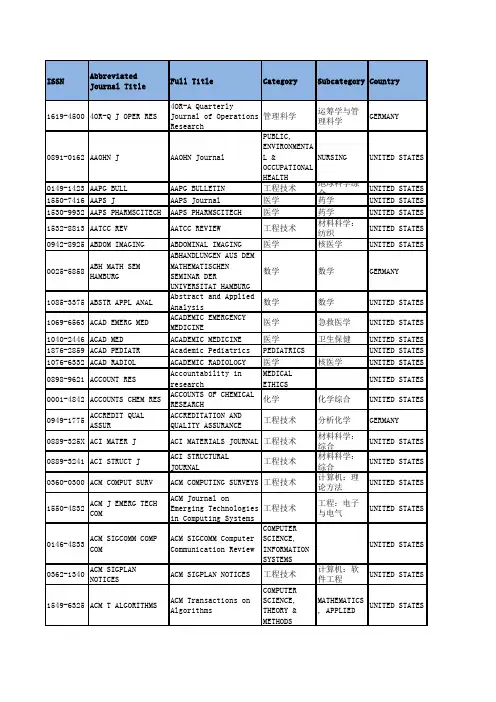
ISSN AbbreviatedJournal TitleFull Title Category Subcategory Country1619-45004OR-Q J OPER RES4OR-A Quarterly Journal 管理科学运筹学与管理科GERMANY0891-0162AAOHN J AAOHN Journal PUBLIC, ENVIRON NURSING UNITED STATES 0149-1423AAPG BULL AAPG BULLETIN工程技术地球科学综合UNITED STATES 1550-7416AAPS J AAPS Journal医学药学UNITED STATES 1530-9932AAPS PHARMSCITECH AAPS PHARMSCITECH医学药学UNITED STATES 1532-8813AATCC REV AATCC REVIEW工程技术材料科学:纺织UNITED STATES 0942-8925ABDOM IMAGING ABDOMINAL IMAGING医学核医学UNITED STATES 0025-5858ABH MATH SEM HAMBURG A BHANDLUNGEN AUS DEM MAT数学数学GERMANY1085-3375ABSTR APPL ANAL Abstract and Applied Ana数学数学UNITED STATES 1069-6563ACAD EMERG MED ACADEMIC EMERGENCY MEDIC医学急救医学UNITED STATES 1040-2446ACAD MED ACADEMIC MEDICINE医学卫生保健UNITED STATES 1876-2859ACAD PEDIATR Academic Pediatrics PEDIATRICS UNITED STATES 1076-6332ACAD RADIOL ACADEMIC RADIOLOGY医学核医学UNITED STATES 0898-9621ACCOUNT RES Accountability in resear MEDICAL ETHICS UNITED STATES 0001-4842ACCOUNTS CHEM RES ACCOUNTS OF CHEMICAL RES化学化学综合UNITED STATES 0949-1775ACCREDIT QUAL ASSURACCREDITATION AND QUALIT工程技术分析化学GERMANY0889-325X ACI MATER J ACI MATERIALS JOURNAL工程技术材料科学:综合UNITED STATES 0889-3241ACI STRUCT J ACI STRUCTURAL JOURNAL工程技术材料科学:综合UNITED STATES 0360-0300ACM COMPUT SURV ACM COMPUTING SURVEYS工程技术计算机:理论方UNITED STATES 1550-4832ACM J EMERG TECH COM A CM Journal on Emerging 工程技术工程:电子与电UNITED STATES 0146-4833ACM SIGCOMM COMP COM A CM SIGCOMM Computer Com COMPUTER SCIENCE, INFORMATI UNITED STATES 0362-1340ACM SIGPLAN NOTICESACM SIGPLAN NOTICES工程技术计算机:软件工UNITED STATES 1549-6325ACM T ALGORITHMS ACM Transactions on Algo COMPUTER SCIENC MATHEMATICS, A UNITED STATES 1544-3558ACM T APPL PERCEPT ACM Transactions on Appl工程技术计算机:软件工UNITED STATES 1544-3566ACM T ARCHIT CODE OP A CM Transactions on Arch工程技术计算机:理论方UNITED STATES 1556-4665ACM T AUTON ADAP SYS A CM Transactions on Auto工程技术计算机:理论方UNITED STATES 1529-3785ACM T COMPUT LOG ACM Transactions on Comp工程技术计算机:理论方UNITED STATES 0734-2071ACM T COMPUT SYST ACM TRANSACTIONS ON COMP工程技术计算机:理论方UNITED STATES 1073-0516ACM T COMPUT-HUM INT A CM Transactions on Comp工程技术计算机:控制论UNITED STATES 0362-5915ACM T DATABASE SYSTACM TRANSACTIONS ON DATA工程技术计算机:软件工UNITED STATES 1084-4309ACM T DES AUTOMAT EL A CM TRANSACTIONS ON DESI工程技术计算机:软件工UNITED STATES 1539-9087ACM T EMBED COMPUT S A CM Transactions on Embe工程技术计算机:软件工UNITED STATES 0730-0301ACM T GRAPHIC ACM TRANSACTIONS ON GRAP工程技术计算机:软件工UNITED STATES 1046-8188ACM T INFORM SYST ACM TRANSACTIONS ON INFO工程技术计算机:信息系UNITED STATES 1094-9224ACM T INFORM SYST SE A CM Transactions on Info工程技术计算机:信息系UNITED STATES 2157-6904ACM T INTEL SYST TEC A CM Transactions on Inte COMPUTER SCIENC COMPUTER SCIEN UNITED STATES 1533-5399ACM T INTERNET TECHN A CM Transactions on Inte工程技术计算机:软件工UNITED STATES 1556-4681ACM T KNOWL DISCOV D A CM Transactions on Know COMPUTER SCIENC COMPUTER SCIEN UNITED STATES 0098-3500ACM T MATH SOFTWAREACM TRANSACTIONS ON MATH工程技术计算机:软件工UNITED STATES 1049-3301ACM T MODEL COMPUT S A CM Transactions on Mode工程技术计算机:跨学科UNITED STATES 1551-6857ACM T MULTIM COMPUTACM Transactions on Mult工程技术计算机:理论方UNITED STATES 0164-0925ACM T PROGR LANG SYS A CM TRANSACTIONS ON PROG工程技术计算机:软件工UNITED STATES 1936-7406ACM T RECONFIG TECHN A CM transactions on reco COMPUTER SCIENCE, HARDWARE UNITED STATES 1550-4859ACM T SENSOR NETWORK A CM Transactions on Sens工程技术电信学UNITED STATES 1049-331X ACM T SOFTW ENG METH A CM TRANSACTIONS ON SOFT工程技术计算机:软件工UNITED STATES1553-3077ACM T STORAGE ACM transactions on stor COMPUTER SCIENC COMPUTER SCIEN UNITED STATES 1559-1131ACM T WEB ACM Transactions on the 工程技术计算机:软件工UNITED STATES 0814-6039ACOUST AUST Acoustics Australia物理声学AUSTRALIA1063-7710ACOUST PHYS+ACOUSTICAL PHYSICS物理声学RUSSIA1944-8244ACS APPL MATER INTER A CS Applied Materials & 工程技术材料科学:综合UNITED STATES 2155-5435ACS CATAL ACS catalysis CHEMISTRY, PHYSICAL UNITED STATES 1554-8929ACS CHEM BIOL ACS Chemical Biology生物生化与分子生物UNITED STATES 1948-7193ACS CHEM NEUROSCI ACS Chemical Neuroscienc BIOCHEMISTRY & CHEMISTRY, MED UNITED STATES 2156-8952ACS COMB SCI ACS Combinatorial Scienc CHEMISTRY, APPL CHEMISTRY, MED UNITED STATES 2161-1653ACS MACRO LETT ACS Macro Letters化学UNITED STATES 1948-5875ACS MED CHEM LETT ACS Medicinal Chemistry CHEMISTRY, MEDICINAL UNITED STATES 1936-0851ACS NANO ACS Nano工程技术材料科学:综合UNITED STATES 2168-0485ACS SUSTAIN CHEM ENG A CS Sustainable Chemistr CHEMISTRY, MULT ENGINEERING, C UNITED STATES 2161-5063ACS SYNTH BIOL ACS Synthetic Biology生物UNITED STATES 1091-5397ACSMS HEALTH FIT J ACSMS HEALTH & FITNESS J医学运动科学UNITED STATES 1610-1928ACTA ACUST UNITED AC A CTA ACUSTICA UNITED WIT物理声学GERMANY0001-5113ACTA ADRIAT ACTA ADRIATICA生物海洋与淡水生物CROATIA0906-4702ACTA AGR SCAND A-ANACTA AGRICULTURAE SCANDI农林科学奶制品与动物科ENGLAND0906-4710ACTA AGR SCAND B-S P A CTA AGRICULTURAE SCANDI农林科学农艺学NORWAY0139-3006ACTA ALIMENT HUNG ACTA ALIMENTARIA农林科学食品科技HUNGARY0001-5172ACTA ANAESTH SCAND ACTA ANAESTHESIOLOGICA S医学麻醉学DENMARK0167-8019ACTA APPL MATH ACTA APPLICANDAE MATHEMA数学应用数学NETHERLANDS 0065-1036ACTA ARITH ACTA ARITHMETICA数学数学POLAND0094-5765ACTA ASTRONAUT ACTA ASTRONAUTICA工程技术工程:宇航UNITED STATES 0001-5237ACTA ASTRONOM ACTA ASTRONOMICA地学天文天文与天体物理POLAND1672-9145ACTA BIOCH BIOPH SIN A CTA BIOCHIMICA ET BIOPH生物生化与分子生物PEOPLES R CHINA 0001-527X ACTA BIOCHIM POL ACTA BIOCHIMICA POLONICA生物生化与分子生物POLAND1509-409X ACTA BIOENG BIOMECHActa of Bioengineering a BIOPHYSICS ENGINEERING, B POLAND1726-569X ACTA BIOETH Acta Bioethica医学卫生政策Chile0001-5296ACTA BIOL CRACOV BOT A CTA BIOLOGICA CRACOVIEN生物植物科学POLAND0236-5383ACTA BIOL HUNG ACTA BIOLOGICA HUNGARICA生物生物学HUNGARY1742-7061ACTA BIOMATER Acta Biomaterialia工程技术材料科学:生物ENGLAND0001-5342ACTA BIOTHEOR ACTA BIOTHEORETICA生物生物学NETHERLANDS 0102-3306ACTA BOT BRAS Acta Botanica Brasilica P LANT SCIENCES BRAZIL0365-0588ACTA BOT CROAT Acta Botanica CroaticaPLANT SCIENCES CROATIA1253-8078ACTA BOT GALLICA ACTA BOTANICA GALLICA生物植物科学FRANCE0187-7151ACTA BOT MEX Acta Botanica Mexicana生物植物科学MEXICO0001-5385ACTA CARDIOL ACTA CARDIOLOGICA医学心血管系统BELGIUM1011-6842ACTA CARDIOL SIN Acta Cardiologica Sinica医学心血管系统TAIWAN0583-6050ACTA CARSOLOGICA ACTA CARSOLOGICA地学地球科学综合SLOVENIA0567-7351ACTA CHIM SINICA ACTA CHIMICA SINICA化学化学综合PEOPLES R CHINA 1318-0207ACTA CHIM SLOV ACTA CHIMICA SLOVENICA化学化学综合SLOVENIA0001-5458ACTA CHIR BELG ACTA CHIRURGICA BELGICA医学外科BELGIUM0001-5415ACTA CHIR ORTHOP TRACTA CHIRURGIAE ORTHOPAE ORTHOPEDICS CZECH REPUBLIC 1508-1109ACTA CHIROPTEROL ACTA CHIROPTEROLOGICA生物动物学POLAND1233-2356ACTA CHROMATOGR ACTA CHROMATOGRAPHICA化学分析化学POLAND0102-8650ACTA CIR BRAS Acta Cirurgica Brasileir医学外科BRAZIL0353-9466ACTA CLIN CROAT Acta Clinica Croatica医学医学:内科CROATIA0108-7673ACTA CRYSTALLOGR A ACTA CRYSTALLOGRAPHICA S化学晶体学DENMARK0108-7681ACTA CRYSTALLOGR B ACTA CRYSTALLOGRAPHICA S化学晶体学DENMARK0108-2701ACTA CRYSTALLOGR C ACTA CRYSTALLOGRAPHICA S化学晶体学DENMARK0907-4449ACTA CRYSTALLOGR D ACTA CRYSTALLOGRAPHICA S生物晶体学DENMARK1744-3091ACTA CRYSTALLOGR F Acta Crystallographica S生物晶体学DENMARK0001-5547ACTA CYTOL ACTA CYTOLOGICA生物病理学UNITED STATES 1330-027X ACTA DERMATOVENER CR A cta Dermatovenerologica医学皮肤病学CROATIA0001-5555ACTA DERM-VENEREOL ACTA DERMATO-VENEREOLOGI医学皮肤病学NORWAY0940-5429ACTA DIABETOL ACTA DIABETOLOGICA医学内分泌学与代谢ITALY1841-0987ACTA ENDOCRINOL-BUCH A cta Endocrinologica-Buc医学内分泌学与代谢ROMANIA0374-1036ACTA ENT MUS NAT PRA A cta Entomologica Musei ENTOMOLOGY CZECH REPUBLIC 0873-9749ACTA ETHOL ACTA ETHOLOGICA生物动物学GERMANY2213-5812ACTA GEOD GEOPHYS Acta Geodaetica et Geoph GEOCHEMISTRY & GEOPHYSICS HUNGARY1214-9705ACTA GEODYN GEOMATER A cta Geodynamica et Geom地学地球化学与地球CZECH REPUBLIC 1581-6613ACTA GEOGR SLOV Acta Geographica Sloveni地学地质学SLOVENIA0001-5709ACTA GEOL POL ACTA GEOLOGICA POLONICA地学地质学POLAND1000-9515ACTA GEOL SIN-ENGL ACTA GEOLOGICA SINICA-EN地学地球科学综合PEOPLES R CHINA 1895-6572ACTA GEOPHYS Acta Geophysica地学地球化学与地球POLAND1861-1125ACTA GEOTECH Acta Geotechnica ENGINEERING, GEOLOGICAL GERMANY1854-0171ACTA GEOTECH SLOV Acta Geotechnica Sloveni地学工程:地质SLOVENIA0001-5792ACTA HAEMATOL-BASELACTA HAEMATOLOGICA医学血液学SWITZERLAND 1827-9635ACTA HERPETOL Acta Herpetologica ZOOLOGY ITALY0065-1281ACTA HISTOCHEM ACTA HISTOCHEMICA生物细胞生物学GERMANY0044-5991ACTA HISTOCHEM CYTOC A CTA HISTOCHEMICA ET CYT生物细胞生物学JAPAN0137-1592ACTA ICHTHYOL PISCAT A cta Ichthyologica et Pi FISHERIES ZOOLOGY POLAND0001-5903ACTA INFORM ACTA INFORMATICA工程技术计算机:信息系GERMANY1359-6454ACTA MATER ACTA MATERIALIA工程技术材料科学:综合UNITED STATES 0168-9673ACTA MATH APPL SIN-E A cta Mathematicae Applic数学应用数学PEOPLES R CHINA 0236-5294ACTA MATH HUNG ACTA MATHEMATICA HUNGARI数学数学HUNGARY0252-9602ACTA MATH SCI ACTA MATHEMATICA SCIENTI数学数学PEOPLES R CHINA 1439-8516ACTA MATH SIN ACTA MATHEMATICA SINICA-数学数学PEOPLES R CHINA 0001-5962ACTA MATH-DJURSHOLMACTA MATHEMATICA数学数学SWEDEN0001-5970ACTA MECH ACTA MECHANICA物理力学AUSTRIA0567-7718ACTA MECH SINICA-PRC A CTA MECHANICA SINICA物理工程:机械PEOPLES R CHINA 0894-9166ACTA MECH SOLIDA SIN A CTA MECHANICA SOLIDA SI物理材料科学:综合PEOPLES R CHINA 0386-300X ACTA MED OKAYAMA ACTA MEDICA OKAYAMA医学医学:研究与实JAPAN1646-0758ACTA MEDICA PORT Acta médica portuguesa MEDICINE, GENERAL & INTERNA PORTUGAL0412-1961ACTA METALL SIN ACTA METALLURGICA SINICA工程技术冶金工程PEOPLES R CHINA 1006-7191ACTA METALL SIN-ENGL A cta Metallurgica Sinica METALLURGY & METALLURGICAL PEOPLES R CHINA 0894-0525ACTA METEOROL SIN Acta Meteorologica Sinic地学气象与大气科学PEOPLES R CHINA 1217-8950ACTA MICROBIOL IMM H A cta Microbiologica et I IMMUNOLOGY MICROBIOLOGY HUNGARY0798-4545ACTA MICROSC MICROSCOPY VENEZUELA1335-1788ACTA MONTAN SLOVACAActa Montanistica Slovac地学地球科学综合SLOVAKIA2075-8251ACTA NATURAE Acta Naturae农林科学林学SOUTH AFRICA 0065-1400ACTA NEUROBIOL EXP ACTA NEUROBIOLOGIAE EXPE医学神经科学POLAND0001-6268ACTA NEUROCHIR ACTA NEUROCHIRURGICA医学临床神经学AUSTRIA0300-9009ACTA NEUROL BELG ACTA NEUROLOGICA BELGICA医学临床神经学BELGIUM0001-6314ACTA NEUROL SCAND ACTA NEUROLOGICA SCANDIN医学临床神经学DENMARK0001-6322ACTA NEUROPATHOL ACTA NEUROPATHOLOGICA医学病理学GERMANY1601-5215ACTA NEUROPSYCHIATRACTA NEUROPSYCHIATRICANEUROSCIENCESPSYCHIATRY DENMARK0001-6349ACTA OBSTET GYN SCAN A CTA OBSTETRICIA ET GYNE医学妇产科学DENMARK0253-505X ACTA OCEANOL SIN ACTA OCEANOLOGICA SINICA地学海洋学PEOPLES R CHINA 0001-6357ACTA ODONTOL SCAND ACTA ODONTOLOGICA SCANDI医学牙科与口腔外科NORWAY1146-609X ACTA OECOL ACTA OECOLOGICA-INTERNAT环境科学生态学FRANCE0284-186X ACTA ONCOL ACTA ONCOLOGICA医学肿瘤学NORWAY1755-375X ACTA OPHTHALMOL ACTA OPHTHALMOLOGICA医学眼科学DENMARK0001-6454ACTA ORNITHOL ACTA ORNITHOLOGICA生物鸟类学POLAND1745-3674ACTA ORTHOP Acta Orthopaedica医学整形外科ENGLAND0001-6462ACTA ORTHOP BELG Acta Orthopaedica Belgic医学整形外科BELGIUM1017-995X ACTA ORTHOP TRAUMATO A cta Orthopaedica et Tra ORTHOPEDICS TURKEY1413-7852ACTA ORTOP BRAS Acta ortopedica brasilei Orthopedics Brazil0001-6489ACTA OTO-LARYNGOL ACTA OTO-LARYNGOLOGICA医学耳鼻喉科学NORWAY0392-100X ACTA OTORHINOLARYNGO A cta Otorhinolaryngologi OTORHINOLARYNGOLOGY ITALY0803-5253ACTA PAEDIATR ACTA PAEDIATRICA医学小儿科ENGLAND0567-7920ACTA PALAEONTOL POLACTA PALAEONTOLOGICA POL地学古生物学POLAND1230-2821ACTA PARASITOL ACTA PARASITOLOGICA医学寄生虫学POLAND0103-2100ACTA PAUL ENFERM Acta Paulista de Enferma NURSING BRAZIL1000-0569ACTA PETROL SIN ACTA PETROLOGICA SINICA G EOLOGY PEOPLES R CHINA 1330-0075ACTA PHARMACEUT Acta Pharmaceutica PHARMACOLOGY & PHARMACY CROATIA1671-4083ACTA PHARMACOL SIN ACTA PHARMACOLOGICA SINI医学化学综合PEOPLES R CHINA 0587-4246ACTA PHYS POL A ACTA PHYSICA POLONICA A物理物理:综合POLAND0587-4254ACTA PHYS POL B ACTA PHYSICA POLONICA B物理物理:综合POLAND1000-3290ACTA PHYS SIN-CH EDACTA PHYSICA SINICA物理物理:综合PEOPLES R CHINA 0323-0465ACTA PHYS SLOVACA ACTA PHYSICA SLOVACA物理物理:综合SLOVAKIA1000-6818ACTA PHYS-CHIM SIN ACTA PHYSICO-CHIMICA SIN化学物理化学PEOPLES R CHINA 1748-1708ACTA PHYSIOL Acta Physiologica医学生理学ENGLAND0231-424X ACTA PHYSIOL HUNG ACTA PHYSIOLOGICA HUNGAR医学生理学HUNGARY0137-5881ACTA PHYSIOL PLANT ACTA PHYSIOLOGIAE PLANTA生物植物科学GERMANY0001-6837ACTA POL PHARM ACTA POLONIAE PHARMACEUT医学药学POLAND1000-3304ACTA POLYM SIN ACTA POLYMERICA SINICA化学高分子科学PEOPLES R CHINA 1785-8860ACTA POLYTECH HUNG ACTA POLYTECHNICA HUNGAR ENGINEERING, MULTIDISCIPLIN HUNGARY0065-1583ACTA PROTOZOOL ACTA PROTOZOOLOGICA生物微生物学POLAND0001-690X ACTA PSYCHIAT SCANDACTA PSYCHIATRICA SCANDI医学精神病学ENGLAND0284-1851ACTA RADIOL ACTA RADIOLOGICA医学核医学SWEDEN0303-464X ACTA REUMATOL PORT Acta Reumatologica Portu医学风湿病学PORTUGAL1644-0692ACTA SCI POL-HORTORU A cta Scientiarum Polonor农林科学园艺POLAND1678-0345ACTA SCI VET Acta Scientiae Veterinar VETERINARY SCIENCES BRAZIL1807-8621ACTA SCI-AGRON Acta Scientiarum. Agrono AGRONOMY BRAZIL1806-2563ACTA SCI-TECHNOL ACTA SCIENTIARUM-TECHNOL综合性期刊综合性期刊BRAZIL0001-6977ACTA SOC BOT POL ACTA SOCIETATIS BOTANICO生物植物科学POLAND0001-7051ACTA THERIOL ACTA THERIOLOGICA生物动物学POLAND0001-706X ACTA TROP ACTA TROPICA医学寄生虫学NETHERLANDS 0001-7213ACTA VET BRNO ACTA VETERINARIA BRNO农林科学兽医学CZECH REPUBLIC 0236-6290ACTA VET HUNG ACTA VETERINARIA HUNGARI农林科学兽医学HUNGARY0044-605X ACTA VET SCAND ACTA VETERINARIA SCANDIN农林科学兽医学DENMARK0567-8315ACTA VET-BEOGRAD ACTA VETERINARIA-BEOGRAD农林科学兽医学SERBIA0001-723X ACTA VIROL ACTA VIROLOGICA医学病毒学SLOVAKIA1217-8837ACTA ZOOL ACAD SCI H A CTA ZOOLOGICA ACADEMIAE生物动物学HUNGARY0324-0770ACTA ZOOL BULGAR ACTA ZOOLOGICA BULGARICA ZOOLOGY BULGARIA0001-7272ACTA ZOOL-STOCKHOLMACTA ZOOLOGICA生物动物学ENGLAND1139-9287ACTAS ESP PSIQUIATRI A CTAS ESPANOLAS DE PSIQU医学精神病学SPAIN0210-4806ACTAS UROL ESP Actas Urologicas Espanol UROLOGY & NEPHROLOGY SPAIN0964-5284ACUPUNCT MED Acupuncture in Medicine I NTEGRATIVE & COMPLEMENTARY ENGLAND0360-1293ACUPUNCTURE ELECTROACUPUNCTURE & ELECTRO-TH医学全科医学与补充UNITED STATES 1570-8705AD HOC NETW Ad Hoc Networks工程技术电信学NETHERLANDS 1551-9899AD HOC SENS WIREL NE A d Hoc & Sensor Wireless工程技术电信学UNITED STATES 1280-8571ADANSONIA ADANSONIA生物植物科学FRANCE1059-7123ADAPT BEHAV ADAPTIVE BEHAVIOR工程技术计算机:人工智ENGLAND0736-5829ADAPT PHYS ACT Q ADAPTED PHYSICAL ACTIVIT医学康复医学UNITED STATES 0306-4603ADDICT BEHAV ADDICTIVE BEHAVIORS医学药物滥用ENGLAND1369-1600ADDICT BIOL ADDICTION BIOLOGY BIOCHEMISTRY & SUBSTANCE ABUS ENGLAND0965-2140ADDICTION ADDICTION医学精神病学ENGLAND0214-4840ADICCIONES Adicciones SUBSTANCE ABUSE SPAIN0263-6174ADSORPT SCI TECHNOLADSORPTION SCIENCE & TEC工程技术工程:化工ENGLAND0929-5607ADSORPTION ADSORPTION-JOURNAL OF TH工程技术工程:化工NETHERLANDS 0065-2113ADV AGRON ADVANCES IN AGRONOMY农林科学农艺学UNITED STATES 0301-5556ADV ANAT EMBRYOL CEL A DVANCES IN ANATOMY EMBR生物发育生物学UNITED STATES 1072-4109ADV ANAT PATHOL ADVANCES IN ANATOMIC PAT医学病理学UNITED STATES 1743-6753ADV APPL CERAM Advances in Applied Cera工程技术材料科学:硅酸ENGLAND0188-7009ADV APPL CLIFFORD AL A dvances in Applied Clif数学物理:数学物理SWITZERLAND 0196-8858ADV APPL MATH ADVANCES IN APPLIED MATH数学应用数学UNITED STATES 2070-0733ADV APPL MATH MECH Advances in Applied Math MATHEMATICS, AP MECHANICS PEOPLES R CHINA 0065-2156ADV APPL MECH ADVANCES IN APPLIED MECH工程技术工程:机械UNITED STATES 0065-2164ADV APPL MICROBIOL ADVANCES IN APPLIED MICR生物生物工程与应用UNITED STATES 0001-8678ADV APPL PROBAB ADVANCES IN APPLIED PROB数学统计学与概率论ENGLAND1687-7969ADV ASTRON Advances in Astronomy ASTRONOMY & ASTROPHYSICS UNITED STATES 0256-1530ADV ATMOS SCI ADVANCES IN ATMOSPHERIC 地学气象与大气科学PEOPLES R CHINA 1049-250X ADV ATOM MOL OPT PHY A DVANCES IN ATOMIC MOLEC物理光学UNITED STATES 0724-6145ADV BIOCHEM ENG BIOT A DVANCES IN BIOCHEMICAL 工程技术生物工程与应用UNITED STATES 0065-2296ADV BOT RES Advances in Botanical Re生物植物科学UNITED STATES 1864-8258ADV CALC VAR Advances in Calculus of MATHEMATICS, AP MATHEMATICS GERMANY0065-230X ADV CANCER RES ADVANCES IN CANCER RESEA医学肿瘤学UNITED STATES 0065-2318ADV CARBOHYD CHEM BI A DVANCES IN CARBOHYDRATE生物生化与分子生物UNITED STATES 0360-0564ADV CATAL ADVANCES IN CATALYSIS化学物理化学UNITED STATES 0951-7197ADV CEM RES ADVANCES IN CEMENT RESEA工程技术材料科学:综合ENGLAND0065-2385ADV CHEM PHYS Advances in Chemical Phy PHYSICS, ATOMIC, MOLECULAR UNITED STATES 1548-5595ADV CHRONIC KIDNEY D A DVANCES IN CHRONIC KIDN医学泌尿学与肾脏学UNITED STATES 0065-2423ADV CLIN CHEM ADVANCES IN CLINICAL CHE医学医学实验技术UNITED STATES 1899-5276ADV CLIN EXP MED Advances in Clinical and MEDICINE, RESEARCH & EXPERI POLAND0001-8686ADV COLLOID INTERFAC A DVANCES IN COLLOID AND 化学物理化学NETHERLANDS 0219-5259ADV COMPLEX SYST ADVANCES IN COMPLEX SYST综合性期刊数学跨学科应用SINGAPORE0924-3046ADV COMPOS MATER ADVANCED COMPOSITE MATER工程技术材料科学:复合NETHERLANDS 0065-2458ADV COMPUT ADVANCES IN COMPUTERS工程技术计算机:软件工UNITED STATES 1019-7168ADV COMPUT MATH ADVANCES IN COMPUTATIONA数学应用数学NETHERLANDS 1687-8108ADV COND MATTER PHYS A dvances in Condensed Ma PHYSICS, CONDENSED MATTER UNITED STATES 1862-5347ADV DATA ANAL CLASSI A dvances in Data Analysi STATISTICS & PROBABILITY GERMANY1687-1847ADV DIFFER EQU-NY Advances in Difference E MATHEMATICS, AP MATHEMATICS UNITED STATES 1079-9389ADV DIFFERENTIAL EQU B ULLETIN OF SYMBOLIC LOG MATHEMATICS, AP MATHEMATICS UNITED STATES0169-409X ADV DRUG DELIVER REV A DVANCED DRUG DELIVERY R医学药学NETHERLANDS 0065-2504ADV ECOL RES ADVANCES IN ECOLOGICAL R环境科学生态学UNITED STATES 1582-7445ADV ELECTR COMPUT EN A dvances in Electrical a工程技术工程:电子与电ROMANIA1614-6832ADV ENERGY MATER Advanced Energy Material CHEMISTRY, PHYS ENERGY & FUELS GERMANY1474-0346ADV ENG INFORM ADVANCED ENGINEERING INF工程技术工程:综合ENGLAND1438-1656ADV ENG MATER ADVANCED ENGINEERING MAT工程技术材料科学:综合GERMANY0965-9978ADV ENG SOFTW ADVANCES IN ENGINEERING 工程技术计算机:跨学科ENGLAND1616-301X ADV FUNCT MATER ADVANCED FUNCTIONAL MATE工程技术材料科学:综合GERMANY0065-2660ADV GENET ADVANCES IN GENETICS生物遗传学UNITED STATES 1615-715X ADV GEOM ADVANCES IN GEOMETRY数学数学GERMANY0065-2687ADV GEOPHYS Advances in GeophysicsGEOSCIENCES, MULTIDISCIPLIN UNITED STATES 1382-4996ADV HEALTH SCI EDUCADVANCES IN HEALTH SCIEN医学卫生保健UNITED STATES 2192-2640ADV HEALTHC MATER Advanced healthcare mate工程技术生物材料Germany?0065-2725ADV HETEROCYCL CHEMADVANCES IN HETEROCYCLIC化学有机化学UNITED STATES 1687-7357ADV HIGH ENERGY PHYS A dvances in High Energy PHYSICS, PARTICLES & FIELDS UNITED STATES 1076-5670ADV IMAG ELECT PHYSAdvances in Imaging and 物理物理:应用UNITED STATES 0065-2776ADV IMMUNOL ADVANCES IN IMMUNOLOGY医学免疫学UNITED STATES 0898-8838ADV INORG CHEM ADVANCES IN INORGANIC CH化学无机化学与核化UNITED STATES 0065-2806ADV INSECT PHYSIOL ADVANCES IN INSECT PHYSI生物昆虫学UNITED STATES 0065-2881ADV MAR BIOL Advances in Marine Biolo MARINE & FRESHWATER BIOLOGY UNITED STATES 0935-9648ADV MATER ADVANCED MATERIALS工程技术材料科学:综合UNITED STATES 0882-7958ADV MATER PROCESS ADVANCED MATERIALS & PRO工程技术材料科学:综合UNITED STATES 1687-8434ADV MATER SCI ENG Advances in Materials Sc MATERIALS SCIENCE, MULTIDIS UNITED STATES 0001-8708ADV MATH ADVANCES IN MATHEMATICS数学数学UNITED STATES 1930-5346ADV MATH COMMUN Advances in Mathematics 工程技术计算机:理论方UNITED STATES 1687-9120ADV MATH PHYS Advances in Mathematical数学应用数学United States 1687-8132ADV MECH ENG Advances in Mechanical E工程技术机械工程United States 1896-1126ADV MED SCI-POLAND Advances in Medical Scie医学医学:研究与实POLAND1687-9309ADV METEOROL Advances in Meteorology地学天文气象与大气科学UNITED STATES 0065-2911ADV MICROB PHYSIOL ADVANCES IN MICROBIAL PH生物生化与分子生物UNITED STATES 1536-1365ADV NONLINEAR STUD ADVANCED NONLINEAR STUDI数学数学UNITED STATES 0161-9268ADV NURS SCI ADVANCES IN NURSING SCIE医学护理UNITED STATES 2161-8313ADV NUTR Advances in nutrition (B医学营养学UNITED STATES 2195-1071ADV OPT MATER Advanced Optical Materia MATERIALS SCIEN OPTICS GERMANY1943-8206ADV OPT PHOTONICS Advances in Optics and P OPTICS UNITED STATES 0065-3055ADV ORGANOMET CHEM ADVANCES IN ORGANOMETALL化学无机化学与核化UNITED STATES 0065-308X ADV PARASIT ADVANCES IN PARASITOLOGY医学寄生虫学UNITED STATES 0001-8732ADV PHYS ADVANCES IN PHYSICS物理物理:凝聚态物ENGLAND0065-3160ADV PHYS ORG CHEM ADVANCES IN PHYSICAL ORG化学物理化学UNITED STATES 1043-4046ADV PHYSIOL EDUC ADVANCES IN PHYSIOLOGY E医学生理学UNITED STATES 0065-3195ADV POLYM SCI ADVANCES IN POLYMER SCIE化学高分子科学GERMANY0730-6679ADV POLYM TECH ADVANCES IN POLYMER TECH工程技术高分子科学UNITED STATES 0921-8831ADV POWDER TECHNOL ADVANCED POWDER TECHNOLO工程技术工程:化工JAPAN1876-1623ADV PROTEIN CHEM STR A dvances in Protein Chem BIOCHEMISTRY & MOLECULAR BI UNITED STATES 0065-3276ADV QUANTUM CHEM ADVANCES IN QUANTUM CHEM化学物理化学UNITED STATES 0169-1864ADV ROBOTICS ADVANCED ROBOTICS工程技术机器人学JAPAN1527-7941ADV SKIN WOUND CAREAdvances in Skin & Wound DERMATOLOGY NURSING UNITED STATES 0273-1177ADV SPACE RES ADVANCES IN SPACE RESEAR地学天文地球科学综合ENGLAND1816-112X ADV STEEL CONSTR Advanced Steel Construct CONSTRUCTION & ENGINEERING, C PEOPLES R CHINA1369-4332ADV STRUCT ENG ADVANCES IN STRUCTURAL E工程技术工程:土木UNITED STATES 0065-3454ADV STUD BEHAV ADVANCES IN THE STUDY OF医学行为科学UNITED STATES 1615-4150ADV SYNTH CATAL ADVANCED SYNTHESIS & CAT化学应用化学GERMANY1095-0761ADV THEOR MATH PHYSAdvances in Theoretical 物理物理:粒子与场UNITED STATES 0741-238X ADV THER ADVANCES IN THERAPY医学药学ENGLAND0972-5768ADV VIB ENG ADVANCES IN VIBRATION EN ENGINEERING, ME MECHANICS INDIA0065-3527ADV VIRUS RES Advances in Virus Resear VIROLOGY UNITED STATES 0309-1708ADV WATER RESOUR ADVANCES IN WATER RESOUR环境科学水资源ENGLAND1875-9637AEOLIAN RES Aeolian Research GEOGRAPHY, PHYSICAL ENGLAND0001-9054AEQUATIONES MATH Aequationes Mathematicae MATHEMATICS, AP MATHEMATICS SWITZERLAND 0393-5965AEROBIOLOGIA AEROBIOLOGIA环境科学环境科学NETHERLANDS 0001-9240AERONAUT J AERONAUTICAL JOURNAL工程技术工程:宇航ENGLAND1680-8584AEROSOL AIR QUAL RES A erosol and air quality ENVIRONMENTAL SCIENCES China0278-6826AEROSOL SCI TECH AEROSOL SCIENCE AND TECH环境科学工程:化工UNITED STATES 1270-9638AEROSP SCI TECHNOL AEROSPACE SCIENCE AND TE工程技术工程:宇航FRANCE0740-722X AEROSPACE AM AEROSPACE AMERICA工程技术工程:宇航UNITED STATES 0364-216X AESTHET PLAST SURG AESTHETIC PLASTIC SURGER医学外科UNITED STATES 1090-820X AESTHET SURG J Aesthetic Surgery Journa SURGERY UNITED STATES 1434-8411AEU-INT J ELECTRON C A EU-INTERNATIONAL JOURNA工程技术电信学GERMANY0001-9704AFINIDAD AFINIDAD化学化学综合SPAIN1021-3589AFR ENTOMOL AFRICAN ENTOMOLOGY生物昆虫学SOUTH AFRICA 1680-6905AFR HEALTH SCI African Health Sciences M EDICINE, GENERAL & INTERNA UGANDA1681-5556AFR INVERTEBR AFRICAN INVERTEBRATES生物动物学SOUTH AFRICA 1608-5914AFR J AQUAT SCI African Journal of Aquat MARINE & FRESHWATER BIOLOGY SOUTH AFRICA 0141-6707AFR J ECOL AFRICAN JOURNAL OF ECOLO环境科学生态学ENGLAND2156-4574AFR J HERPETOL AFRICAN JOURNAL OF HERPE ZOOLOGY SOUTH AFRICA 1814-232X AFR J MAR SCI AFRICAN JOURNAL OF MARIN生物海洋与淡水生物SOUTH AFRICA 1994-8220AFR J PSYCHIATRY African Journal of Psych PSYCHIATRY SOUTH AFRICA 1022-0119AFR J RANGE FOR SCIAfrican Journal of Range ECOLOGY ENVIRONMENTAL SOUTH AFRICA 0189-6016AFR J TRADIT COMPLEM A frican Journal of Tradi医学全科医学与补充NIGERIA2305-7963AFR NAT HIST African Natural History B IODIVERSITY CONSERVATION SOUTH AFRICA 1562-7020AFR ZOOL AFRICAN ZOOLOGY生物动物学SOUTH AFRICA 0161-9152AGE AGE医学老年医学UNITED STATES 0002-0729AGE AGEING AGE AND AGEING医学老年医学ENGLAND1568-1637AGEING RES REV AGEING RESEARCH REVIEWS医学老年医学IRELAND0096-140X AGGRESSIVE BEHAV AGGRESSIVE BEHAVIOR医学行为科学UNITED STATES 1474-9718AGING CELL AGING CELL生物老年医学ENGLAND1594-0667AGING CLIN EXP RES AGING CLINICAL AND EXPER医学老年医学ITALY1368-5538AGING MALE Aging Male医学泌尿学与肾脏学ENGLAND1360-7863AGING MENT HEALTH AGING & MENTAL HEALTH医学精神病学ENGLAND1945-4589AGING-US Aging CELL BIOLOGY UNITED STATES 0169-5150AGR ECON-BLACKWELL AGRICULTURAL ECONOMICS管理科学农业经济与政策NETHERLANDS 0139-570X AGR ECON-CZECH Agricultural Economics-Z AGRICULTURAL ECONOMICS & PO CZECH REPUBLIC 0167-8809AGR ECOSYST ENVIRONAGRICULTURE ECOSYSTEMS &环境科学环境科学NETHERLANDS 1459-6067AGR FOOD SCI AGRICULTURAL AND FOOD SC农林科学农业综合FINLAND1461-9555AGR FOREST ENTOMOL AGRICULTURAL AND FOREST 农林科学昆虫学ENGLAND0168-1923AGR FOREST METEOROLAGRICULTURAL AND FOREST 农林科学林学NETHERLANDS 0002-1482AGR HIST AGRICULTURAL HISTORY农林科学科学史与科学哲UNITED STATES 0889-048X AGR HUM VALUES AGRICULTURE AND HUMAN VA农林科学科学史与科学哲NETHERLANDS1671-2927AGR SCI CHINA Agricultural Sciences in AGRICULTURE, MULTIDISCIPLIN PEOPLES R CHINA 0308-521X AGR SYST AGRICULTURAL SYSTEMS农林科学农业综合NETHERLANDS 0378-3774AGR WATER MANAGE AGRICULTURAL WATER MANAG农林科学农艺学NETHERLANDS 1663-7852AGRARFORSCH SCHWEIZ+A GRARFORSCH SCHWEIZ AGRICULTURE, MULTIDISCIPLIN SWITZERLAND 0303-1853AGREKON Agrekon AGRICULTURAL ECONOMICS & PO SOUTH AFRICA 0742-4477AGRIBUSINESS Agribusiness农林科学食品科技UNITED STATES 1722-6996AGRO FOOD IND HI TEC A GRO FOOD INDUSTRY HI-TE工程技术生物工程与应用ITALY0002-1857AGROCHIMICA AGROCHIMICA农林科学土壤科学ITALY1405-3195AGROCIENCIA-MEXICO AGROCIENCIA农林科学农业综合MEXICO2168-3565AGROECOL SUST FOOD Agroecology and Sustaina AGRICULTURE, MULTIDISCIPLIN UNITED STATES 0167-4366AGROFOREST SYST AGROFORESTRY SYSTEMS农林科学林学NETHERLANDS 0002-1962AGRON J AGRONOMY JOURNAL农林科学农艺学UNITED STATES 1774-0746AGRON SUSTAIN DEV Agronomy for Sustainable农林科学农艺学FRANCE0921-7126AI COMMUN AI COMMUNICATIONS工程技术计算机:人工智NETHERLANDS 0890-0604AI EDAM AI EDAM-ARTIFICIAL INTEL工程技术工程:制造UNITED STATES 0738-4602AI MAG AI MAGAZINE工程技术计算机:人工智UNITED STATES 0001-1452AIAA J AIAA JOURNAL工程技术工程:宇航UNITED STATES 0001-1541AICHE J AICHE JOURNAL工程技术工程:化工UNITED STATES 0269-9370AIDS AIDS医学病毒学UNITED STATES 1087-2914AIDS PATIENT CARE ST A IDS PATIENT CARE AND ST医学传染病学UNITED STATES 0889-2229AIDS RES HUM RETROVAIDS RESEARCH AND HUMAN 医学病毒学UNITED STATES 1742-6405AIDS RES THER AIDS Research and Therap INFECTIOUS DISEASES ENGLAND1139-6121AIDS REV AIDS REVIEWS医学传染病学SPAIN2158-3226AIP ADV AIP Advances NANOSCIENCE & N MATERIALS SCIE UNITED STATES 1873-9318AIR QUAL ATMOS HLTHAir Quality, Atmosphere ENVIRONMENTAL SCIENCES NETHERLANDS 1748-8842AIRCR ENG AEROSP TEC A IRCRAFT ENGINEERING AND工程技术工程:宇航ENGLAND1608-5906AJAR-AFR J AIDS RESAJAR-African Journal of 医学公共卫生、环境SOUTH AFRICA 0341-051X AKTUEL RHEUMATOL AKTUELLE RHEUMATOLOGIE医学风湿病学GERMANY0001-7868AKTUEL UROL AKTUELLE UROLOGIE医学泌尿学与肾脏学GERMANY0311-5518ALCHERINGA ALCHERINGA地学古生物学ENGLAND0741-8329ALCOHOL ALCOHOL医学毒理学UNITED STATES 0735-0414ALCOHOL ALCOHOLISM ALCOHOL AND ALCOHOLISM医学药物滥用ENGLAND0145-6008ALCOHOL CLIN EXP RES A LCOHOLISM-CLINICAL AND 医学药物滥用UNITED STATES 0002-5100ALDRICHIM ACTA ALDRICHIMICA ACTA化学有机化学UNITED STATES 1980-0436ALEA-LAT AM J PROBAB L atin American Journal o STATISTICS & PROBABILITY BRAZIL2211-9264ALGAL RES Algal Research-Biomass B BIOTECHNOLOGY & APPLIED MIC NETHERLANDS 1005-3867ALGEBR COLLOQ ALGEBRA COLLOQUIUM数学数学PEOPLES R CHINA 1472-2739ALGEBR GEOM TOPOL Algebraic and Geometric 数学数学ENGLAND0002-5232ALGEBR LOG+Algebra and Logic数学数学RUSSIA1937-0652ALGEBR NUMBER THEORY A lgebra and Number Theor MATHEMATICS UNITED STATES 1386-923X ALGEBR REPRESENT THALGEBRAS AND REPRESENTAT数学数学NETHERLANDS 0002-5240ALGEBR UNIV ALGEBRA UNIVERSALIS数学数学SWITZERLAND 1748-7188ALGORITHM MOL BIOL Algorithms for Molecular生物生化研究方法ENGLAND0178-4617ALGORITHMICA ALGORITHMICA工程技术计算机:软件工UNITED STATES 0269-2813ALIMENT PHARM THER ALIMENTARY PHARMACOLOGY 医学胃肠肝病学ENGLAND0971-4693ALLELOPATHY J ALLELOPATHY JOURNAL农林科学农艺学INDIA0301-0546ALLERGOL IMMUNOPATHALLERGOLOGIA ET IMMUNOPA医学过敏SPAIN0344-5062ALLERGOLOGIE ALLERGOLOGIE医学过敏GERMANY0105-4538ALLERGY ALLERGY医学过敏ENGLAND2092-7355ALLERGY ASTHMA IMMUN T he American Academy of ALLERGY IMMUNOLOGY SOUTH KOREA 1088-5412ALLERGY ASTHMA PROCALLERGY AND ASTHMA PROCE医学过敏UNITED STATES 0002-5852ALLG FORST JAGDZTG ALLGEMEINE FORST UND JAG农林科学林学GERMANY1664-2201ALPINE BOT Alpine Botany PLANT SCIENCES SWITZERLAND 1078-6791ALTERN THER HEALTH M A lternative therapies in INTEGRATIVE & COMPLEMENTARY United States 1868-596X ALTEX-ALTERN ANIM EX A LTEX-ALTERNATIVES TO AN MEDICINE, RESEARCH & EXPERI GERMANY0893-0341ALZ DIS ASSOC DIS ALZHEIMER DISEASE & ASSO医学病理学UNITED STATES 1552-5260ALZHEIMERS DEMENT Alzheimers & Dementia医学临床神经学UNITED STATES 1758-9193ALZHEIMERS RES THERAlzheimer\'s Research an医学神经病学United Kingdom 0002-7626AM BEE J AMERICAN BEE JOURNAL生物昆虫学UNITED STATES 0002-7685AM BIOL TEACH The American Biology Tea BIOLOGY EDUCATION, SCI UNITED STATES 0002-7812AM CERAM SOC BULL AMERICAN CERAMIC SOCIETY工程技术材料科学:硅酸UNITED STATES 0002-838X AM FAM PHYSICIAN AMERICAN FAMILY PHYSICIA医学医学:内科UNITED STATES 0002-8444AM FERN J AMERICAN FERN JOURNAL生物植物科学UNITED STATES 0002-8703AM HEART J AMERICAN HEART JOURNAL医学心血管系统UNITED STATES 0002-9092AM J AGR ECON AMERICAN JOURNAL OF AGRI管理科学农业经济与政策UNITED STATES 1533-3175AM J ALZHEIMERS DISAmerican Journal of Alzh GERIATRICS & GE CLINICAL NEURO UNITED STATES 1059-0889AM J AUDIOL American Journal of Audi AUDIOLOGY & SPE OTORHINOLARYNG UNITED STATES 1526-5161AM J BIOETHICS AMERICAN JOURNAL OF BIOE社会科学科学史与科学哲UNITED STATES 0002-9122AM J BOT AMERICAN JOURNAL OF BOTA生物植物科学UNITED STATES 2156-6976AM J CANCER RES American Journal of Canc ONCOLOGY UNITED STATES 0002-9149AM J CARDIOL AMERICAN JOURNAL OF CARD医学心血管系统UNITED STATES 1175-3277AM J CARDIOVASC DRUG A merican Journal of Card医学心血管系统NEW ZEALAND 0192-415X AM J CHINESE MED AMERICAN JOURNAL OF CHIN医学全科医学与补充UNITED STATES 1175-0561AM J CLIN DERMATOL AMERICAN JOURNAL OF CLIN医学皮肤病学NEW ZEALAND 0002-9165AM J CLIN NUTR AMERICAN JOURNAL OF CLIN医学营养学UNITED STATES 0277-3732AM J CLIN ONCOL-CANC A MERICAN JOURNAL OF CLIN医学肿瘤学UNITED STATES 0002-9173AM J CLIN PATHOL AMERICAN JOURNAL OF CLIN医学病理学UNITED STATES 1062-3264AM J CRIT CARE AMERICAN JOURNAL OF CRIT医学护理UNITED STATES 0894-8275AM J DENT AMERICAN JOURNAL OF DENT医学牙科与口腔外科UNITED STATES 0193-1091AM J DERMATOPATH AMERICAN JOURNAL OF DERM医学皮肤病学UNITED STATES 0095-2990AM J DRUG ALCOHOL AB A MERICAN JOURNAL OF DRUG SUBSTANCE ABUSE UNITED STATES 0735-6757AM J EMERG MED AMERICAN JOURNAL OF EMER医学急救医学UNITED STATES 0002-9254AM J ENOL VITICULT AMERICAN JOURNAL OF ENOL农林科学生物工程与应用UNITED STATES 0002-9262AM J EPIDEMIOL AMERICAN JOURNAL OF EPID医学公共卫生、环境UNITED STATES 0195-7910AM J FOREN MED PATHAMERICAN JOURNAL OF FORE医学病理学UNITED STATES 0002-9270AM J GASTROENTEROL AMERICAN JOURNAL OF GAST医学胃肠肝病学UNITED STATES 1064-7481AM J GERIAT PSYCHIAT A MERICAN JOURNAL OF GERI医学精神病学UNITED STATES 1543-5946AM J GERIATR PHARMAC A merican Journal Geriatr GERIATRICS & GE PHARMACOLOGY &UNITED STATES 1079-2082AM J HEALTH-SYST PHAMERICAN JOURNAL OF HEAL医学药学UNITED STATES 0361-8609AM J HEMATOL AMERICAN JOURNAL OF HEMA医学血液学UNITED STATES 1049-9091AM J HOSP PALLIAT ME A merican Journal of Hosp HEALTH CARE SCIENCES & SERV UNITED STATES 1042-0533AM J HUM BIOL AMERICAN JOURNAL OF HUMA生物生物学UNITED STATES 0002-9297AM J HUM GENET AMERICAN JOURNAL OF HUMA生物遗传学UNITED STATES 0895-7061AM J HYPERTENS AMERICAN JOURNAL OF HYPE医学外周血管病UNITED STATES 0271-3586AM J IND MED AMERICAN JOURNAL OF INDU医学公共卫生、环境UNITED STATES 0196-6553AM J INFECT CONTROLAMERICAN JOURNAL OF INFE医学传染病学UNITED STATES 0272-6386AM J KIDNEY DIS AMERICAN JOURNAL OF KIDN医学泌尿学与肾脏学UNITED STATES 1088-0224AM J MANAG CARE AMERICAN JOURNAL OF MANA医学卫生保健UNITED STATES。
Genetic Epidemiology34:479–491(2010)Design of Association Studies with Pooled or Un-pooledNext-Generation Sequencing DataSu Yeon Kim,1ÃYingrui Li,2Yiran Guo,2Ruiqiang Li,2Johan Holmkvist,3Torben Hansen,3,4Oluf Pedersen,3,5,6Jun Wang,2,7and Rasmus Nielsen1,2,71Departments of Integrative Biology and Statistics,UC Berkeley,Berkeley,California2Beijing Genomics Institute,Shenzhen,China3Hagedorn Research Institute,Gentofte,Denmark4Faculty of Health Science,University of Southern Denmark,Odense,Denmark5Faculty of Health Science,University of Aarhus,Aarhus,Denmark6Institute of Biomedical Science,University of Copenhagen,Denmark7Department of Biology,University of Copenhagen,Copenhagen,DenmarkMost common hereditary diseases in humans are complex and rge-scale genome-wide association studies based on SNP genotyping have only identified a small fraction of the heritable variation of these diseases.One explanation may be that many rare variants(a minor allele frequency,MAF o5%),which are not included in the common genotyping platforms,may contribute substantially to the genetic variation of these diseases.Next-generation sequencing,which would allow the analysis of rare variants,is now becoming so cheap that it provides a viable alternative to SNP genotyping.In this paper,we present cost-effective protocols for using next-generation sequencing in association mapping studies based on pooled and un-pooled samples,and identify optimal designs with respect to total number of individuals,number of individuals per pool,and the sequencing coverage.We perform a small empirical study to evaluate the pooling variance in a realistic setting where pooling is combined with exon-capturing.To test for associations,we develop a likelihood ratio statistic that accounts for the high error rate of next-generation sequencing data.We also perform extensive simulations to determine the power and accuracy of this method.Overall,our findings suggest that with a fixed cost,sequencing many individuals at a more shallow depth with larger pool size achieves higher power than sequencing a small number of individuals in higher depth with smaller pool size,even in the presence of high error rates.Our results provide guidelines for researchers who are developing association mapping studies based on next-generation sequencing.Genet.Epidemiol. 34:479–491,2010.r2010Wiley-Liss,Inc.Key words:pooled samples;association mapping;rare allele;optimal design;next-generation sequencingContract grant sponsors:The Lundbeck Foundation Centre of Applied Medical Genomics in Personalized Disease Prediction,Prevention and Care(LuCAMP);NIH;Contract grant numbers:R01-HG003229;R01-MH084691.Additional Supporting Information may be found in the online version of this article.ÃCorrespondence to:Su Yeon Kim,Departments of Integrative Biology and Statistics,University of California,Berkeley,3060Valley Life Sciences Bldg]3140,Berkeley CA94720.E-mail:suyeonkim@Received2October2009;Revised28January2010;Accepted21February2010Published online15June2010in Wiley InterScience().DOI:10.1002/gepi.20501INTRODUCTION Determining the genetic basis of complex genetic diseases is one of the main challenges in human genetics [Altshuler et al.,2008;Frazer et al.,2009;Kruglyak,2008; McCarthy and Hirschhorn,2008;McCarthy et al.,2008].association mapping studies(GWAs) revealed many susceptibility loci for complex diseases such as diabetes,hypertension,bipolar,Crohn’s disease and others[Barrett et al.,2008;Hindorff et al.,2009; Thomas et al.,2009;Wellcome Trust Case Control,2007]. However,despite many successes,a majority of the additive generic variance still remains unexplained [Altshuler et al.,2008;Frazer et al.,2009;Kruglyak,2008; McCarthy and Hirschhorn,2008].One explanation for this result is that rare variants might play a significant role in complex diseases.Since genotyping platforms include SNPs that are discovered by sequencing a small panel, most of the included SNPs are common variants [MAF45%;Frazer et al.,2007]in previous GWAs.The importance of rare variants in understanding complex traits has been discussed in a number of recent studies [Azzopardi et al.,2008;Bodmer and Bonilla,2008;Cohen et al.,2004,2006;Gorlov et al.,2008;Iyengar and Elston, 2007;Ji et al.,2008;McClellan et al.,2007;Polychronakos, 2008].For example,in a re-sequencing study of three genes,Ji et al.[2008]found several rare mutations related to hypertension,appearing in the heterozygous state. The cost of re-sequencing has dropped dramatically over the past few years[Bentley et al.,2008;Wang et al., 2008;Wheeler et al.,2008].This recent development has made next-generation re-sequencing a viable alternative to SNP genotyping based on chips or other platformsr2010Wiley-Liss,Inc.[Bentley et al.,2008;Hillier et al.,2008;Van Tassell et al., 2008].However,in most studies full genome-wide re-sequencing at a high depth is still prohibitively expensive. Instead,two strategies are being used to reduce costs:(1) sequencing of the exome only—using various exon-capturing techniques and(2)the use of pooled samples. With recent developments in exon-capturing techniques, most of the human exons can be efficiently captured [Albert et al.,2007;Gnirke et al.,2009;Hodges et al.,2007; Krishnakumar et al.,2008;Okou et al.,2007;Porreca et al., 2007].While many functional variant may lie in non-coding regions,many of the mutations with the best potential for translational medicine are in coding regions,providing an extra motivation for focusing on the exome[Jones et al., 2009;Kryukov et al.,2009;Raymond et al.,2009].The use of pooled samples is particularly attractive in two-stage designs[Chi et al.,2009;Skol et al.,2006;Wang et al.,2006;Zuo et al.,2006,2008].In the first stage of a two-stage design,a large number of markers are geno-typed,or re-sequencing is being used,on a moderate number of individuals.In the second stage,the most promising markers from the first stage are further examined by genotyping in a larger set of individuals. To reduce the cost of large-scale association studies,pools of DNA from many individuals have been successfully used in the first stage of the two-stage design[Bansal et al., 2002;Boss et al.,2009;Nejentsev et al.,2009;Norton et al., 2004;Sham et al.,2002].The use of pooled samples reduces cost,particularly when combined with techniques such as exon-capturing,which has a cost associated with each pool to which it is applied.With the advent of cheap re-sequencing techniques,a viable,an economically attractive protocol for GWAs may include an initial stage of exon-capturing and re-sequencing in pooled samples [Druley et al.,2009;Ingman and Gyllensten,2008;Jones et al.,2009;Lavebratt and Sengul,2006],and a second stage based on genotyping of the best candidate SNPs from the first stage.Such a protocol is cost effective and has the potential to detect rare SNPs that would not be captured by any of the major genotyping platforms. Here,we examine the feasibility of this protocol,using both pooled and un-pooled samples.There are a number of issues related to this protocol that warrants further research,including the effects of sequencing errors and pooling variance,and the consequences of these factors for the choice of optimal experimental protocol.We first make a limited experimental study based on Nimblegen s exons capturing,and sequencing using the Illumina genome analyzer s,to determine the feasibility of studies based on a combination of these techniques.We then use the results of this study to model the protocol using realistic parameters.We perform simulations to determine power and to identify optimal designs.METHODSEXPERIMENTAL DESIGNOur analyses assume a two-stage design,where the first stage may include exon-capturing and/or pooled samples, and will involve next-generation re-sequencing.The second stage is based on traditional SNP genotyping of the most promising variants from the first stage.While the properties and design of the second stage have been explored extensively in the previous work[Skol et al.,2006;Zuo et al.,2008],the use of next-generation sequencing for the first stage[e.g.,Nejentsev et al.,2009] has not previously been explored to the same degree.EXPERIMENTAL DATAA small empirical study was conducted to evaluate feasibility of this novel approach and assess the variability introduced in real experiments.Genomic DNA was purified from blood leucocytes from five Danish volun-teers recruited at Steno Diabetes Center,Denmark.The volunteers gave informed consent and the research protocol,which is focused on studies of the genetics of metabolic disorders,was approved by the local Ethical Committee of Copenhagen.Two pools were constructed, one with two individuals and the other with five individuals.Pooling DNA of individuals was done following the pre-PCR protocol described in Lavebratt and Sengul[2006]with some small modification.In our procedure,individual DNA was diluted to10ng/m l instead to5ng/m l before pooling.Our pooling procedure is summarized in Supplementary Figure1.Exon-capturing was performed using a NimbleGen chip s[Albert et al., 2007],which captures6,726‘‘exonic’’regions covering $5Mb sequence.The DNA sample in each pool was fragmented to an average size of500bp,end repaired, ligated to Solexa adaptors s,hybridized and captured using the high-density oligonucleotide microarray.Finally, the DNA sample was amplified using PCR,and the eluted sample from it was sequenced using Solexa Genome Analyzer II s.Solexa sequence reads were aligned to the reference human genome(NCBI build36)using read-alignment program SOAP[Li et al.,2008].Pooling efficacy.In our design,reads from indivi-duals in pools could be identified after re-sequencing because they were re-sequenced both individually and in pools.The individual re-sequencing allowed the identifi-cation of unique mutations specific to each individual. Pooling efficacy was then measured by the degree to which the pooled DNA was composed of an equal contribution of DNA from each individual.Consider a pool with P s number of individuals.When using pooled samples,individual DNA samples are measured and pooled,then a fixed amount of pooled DNA is prepared for sequencing(Supplementary Fig.1). Therefore,the sequencing depth of each individual is not controlled directly,but is a function of the proportion of DNA from each individual and the total sequencing depth. However,the mean depth for an individual is expected to be proportional to the amount of DNA of that individual in the pool.Therefore,one way to model the pooling efficacy is as follows:Y i;B;Y i;b$PoissonðmÂR iÞ;where m¼D p2andR i¼W iP j W j;W i$G a p;1a p ;ð1Þwhere Y i;B and Y i;b are the counts of read bases generated from each of the two alleles(B and b)in individual i,D p is the pool depth and R i is the proportion of the DNA from each individual.W i is the DNA amount of individual i. Note that if pooling is perfect,then W i is the same across individuals and R i is expected to be1=P s.In reality, however,W i is likely to vary,and one way to model this480Kim et al. Genet.Epidemiol.variation is to use a gamma distribution,as the gamma distribution provides a very flexible family of continuous positive variables using only two parameters.The gamma distribution is a favorite choice in statistics for modeling such distributions and the properties of the distribution are well known.In our case,when W i follows a gamma distribution with a shared rate parameter,ðR 1;...;R P s Þ$Dirichlet ða p Þ.Note that the mean and the variance of each component in the Dirichlet distribution is:E ðR i Þ¼1P sand Var ðR i Þ¼P s À1P 2s Âða p P s 11Þð2ÞThe parameter a p controlling the pooling variance isestimated from the data using the maximum likelihood method.Exon-capturing efficacy.Variation in exon-captur-ing efficacy introduces extra variation in read depth across the sites.High depth implies efficient exon-capturing,and low depth implies poor exon-capturing performance.We model the exon-capturing efficacy as a gamma distribution:Y j $Poisson ðm t ÂC j Þand C j $G a c ;1a c;ð3Þwhere Y j is the observed total depth at site j and m t is the expected total sequence depth given by experimental design.C j controls the exon-capturing efficacy at site j .Large values of C j imply efficient capturing on site j and small values C j imply poor exon-capturing efficacy .Exon-capturing might fail for some sites.In that case,the capturing efficacy can be modeled as a mixture of a point mass at zero and a gamma distribution.We estimate the sequencing error rate conservatively as the average mismatch rate.Specifically,all the counts of pairwise mismatches between the reference human gen-ome and aligned reads were averaged across targeted regions as well as across the aligned reads.EXPERIMENTAL COSTIn order to illustrate how to make cost effective choices regarding optimal design,we will make assumptions regarding experimental cost.Obviously,costs can change rapidly and design of individual studies should take current costs into consideration.It should be noticed that our general conclusions are not dependent on the specificassumptions regarding costs made here.In the most general pooled design,the total cost of an experiment has four components:cost of obtaining DNA samples,cost of pooling DNA samples,exon-capturing,and sequencing.We will in the following ignore the cost of obtaining DNA samples and assume that such samples are available before the onset of the study.The DNA pooling cost mainly depends on the total number of individuals that are pooled.The key step in pooling is to dilute and accurately quantify the DNA concentration of each individual sample.We will here assume,for the sake of example,that initial preparation for each individual in a pool costs $2.We will assume that exon-capturing cover-ing all human exons ($30Mb)costs $3,500for each pool.The cost of sequencing is divided into two parts,a cost of preparation of the DNA sample which we will assume is $200,and a cost associated with the production of sequencing reads.We will assume a cost of $500for Solexa-sequencing of a 30Mb exonic region at a depth of 2Â(for details,see Supplementary Methods).The assumed experimental costs are summarized in Table I.Notice that for individual sequencing,the exon-capturing cost rapidly increases with the number of individuals,even if the sequencing cost is fixed.The use of pooled samples allows deeper sequencing at the same cost.LIKELIHOOD RATIO TESTThe data produced by next-generation sequencing differ from that of SNP-chips.Genotyping,in principle,reveals the two alleles in each individual in each targeted nucleotide site.Next-generation re-sequencing produces large amounts of short reads.After mapping to the reference genome,an alignment of reads across the targeted regions is obtained.A schematic example of re-sequencing data at a single site is shown in Figure 1.In this particular example,cases and controls each consist of two pools with two individuals.Each nucleotide site in each individual is represented in reads a random number of times.It is generally unknown which of the two alleles in an individual is represented in a particular read.Also,there is a high probability of sequencing errors.One of the main challenges in the use of next-generation sequencing data in association mapping studies aimed at detecting associations with rare SNPs is to distinguish between true SNPs and false SNPs caused by sequencingTABLE I.Examples of experimental costs for re-sequencing of pooled or un-pooled DNA samples in targeted regionsNumber of Pool Depth Experimental cost (unit:$1,000)cases/controls size per indiv.Pooling Exon-capturingSequencing Total 50018Â03,5002,2005,700100014Â07,0002,4009,400200012Â014,0002,80016,80050018Â03,5002,2005,702100024Â43,5002,2005,704200042Â83,5002,2005,708400081Â163,5002,2005,716100054Â41,4002,0803,484100058Â41,4004,0805,4841000516Â41,4008,0809,484The cost settings are obtained by assuming Solexa-sequencing of pooled or unpooled DNA samples on the human exome ($30Mb),captured using Nimblegene arrays.481Design of Association Studies Genet.Epidemiol.errors.The nature of the data is such that,even after basic bioinformatic quality control procedures,sequencing errors remain a serious problem.Power can be gained by incorporating the possibility of errors into the statistical framework used for detecting associations.There is a trade-off between eliminating too many putative SNPs as sequencing errors,thereby eliminating a number of true SNPs,and eliminating too few putative SNPs,and then suffer a serious multiple testing problem.A full likelihood approach incorporated into the association mapping testing procedure may help to directly identify the optimal balance between eliminating too few or too many putative SNPs in a particular design,and to select the putative SNPs that most likely are associated with the trait.We have developed a simple version of such a likelihood approach.We have also extended this method so it can be applied to provide a more powerful method for pooling designs.In the following we will discuss how the method can be developed into a likelihood ratio test,which we apply for each individual site to test the difference in minor allele frequencies:H0:p1¼p2ð¼p0Þvs.H A:p1¼p2,where p1 and p2are the minor allele frequency in cases and controls, respectively.We test each site,j,independently of each other. Suppose that for both cases and controls,there are N pool pools with P s individuals per pool.After re-sequencing, for each pool m,an alignment of reads OðmÞ¼ðXðmÞ1;...; XðmÞVðmÞÞ0is obtained,where XðmÞk is the k th read among the total VðmÞreads in locus j.Let GðmÞbe the number of A (minor)alleles in pool m.(Note that GðmÞis not observed.) Each observed read is a copy of one of the alleles in a pool, but copying is potentially made with errors.Note that below,we assume a relatively simple structure in which e¼Pðread¼A j allele¼aÞ¼Pðread¼a j allele¼AÞ.How-ever,our statistical model can easily be extended to incorporate a more complicated error structure.In Equation(4)below,instead of a binomial distribution modeling the conditional read counts a multinomial distribution with probability that takes each type-specific error rate(e b;b0)into account could be used:e b;b0¼Pðread¼b j allele¼b0Þ,where b;b02ðA;C;G;TÞ.Our likelihood ratio statistic(LRT)is computed as: LRT¼À2logLð^p0j O;eÞ12¼À2log Q2N pool m¼1PðOðmÞj^p0;eÞQ N pool m¼1PðOðmÞj^p1;eÞQ2N pool m¼N pool11PðOðmÞj^p2;eÞ0@1A;and,the likelihood for each pool m is computed as: PðOðmÞj p0;eÞ¼X GðmÞPðGðmÞj p0ÞPðOðmÞj GðmÞ;eÞ¼X S pool k¼0PðGðmÞ¼k j p0ÞY VðmÞr¼1PðXðmÞr j GðmÞ¼k;eÞ!¼X S pool k¼0 Binomðk;S pool;p0ÞBinomðnðmÞA;VðmÞ;kS poolð1ÀeÞ11Àk Spoole ;ð4Þwhere nðmÞA is the number of A in reads.The last equation is motivated as follows:GðmÞfollows a binomial distribution with S pool(52P s)number of trials each with probability p0 (assuming no population structure).Given that there are k minor alleles(A)in a pool,each read becomes of type A with probability k/S pool if there are no errors.If errors occur,the probability iskS poolð1ÀeÞ11Àk SpooleAssuming homogeneity in sequencing efficiency across chromosomes(i.e.,the number of sequenced reads for each allele follows the same distribution)and independence, the number of A reads in the pool(nðmÞA)follows a binomial distribution.Notice that the total number of reads in each pool(VðmÞ)is assumed to be given.Cases ControlsGenotype ReadbaseGenotype ReadbaseFig.1.Schematic illustration of the next-generation sequencing data at a single position.Each case and control sample consist of two pools with two individuals in each pool.The two alleles of each individual are shown in the‘‘Genotype’’column.There are two types of alleles(A and a).Each allele appears a random number of times,and may have been affected by sequencing errors.482Kim et al.Genet.Epidemiol.The performance of the likelihood ratio statistic for hypothesis testing based on individual sites could be evaluated in terms of Type I and Type II errors in a classical sense.However,our objective is to evaluate design issues relating to a two-step design in which next-generation sequencing is used in the first step of the design.We therefore evaluate the efficacy of the statistic in selecting a causal SNP among a pre-determined number of selected sites.Accordingly,the power is determined as the prob-ability of including the causative SNP among the set of selected sites(e.g.,the probability of including the causal SNP among50sites selected from a total of300,000sites).We do not evaluate the Type I and Type II error of the test in the classical sense,although we will present simulation results showing that P-values calculated based on the likelihood ratio test statistic under suitable conditions follow a uniform distribution,and hence,that the test will have a Type I error rate equal to the nominal significance level. Maximization of the likelihood function was done using a bounded version of the Broyden-Fletcher-Goldfarb-Shanno(BFGS)algorithm[Broyden,1970;Fletcher,1970; Goldfarb,1970;Shanno,1970]or the Simplex method [Nelder and Mead,1965].Overall,the Simplex method algorithm performed better,presumably because the computational expense in numerically approximating the gradient in the BFGS algorithm overwhelmed the faster convergence of this algorithm for this low-dimensional puting our LRT statistic for1,000sites takes 69sec with the Simplex algorithm,but136sec with BFGS algorithm on a standard desktop computer,for a total of 10,000reads from500cases and500controls in1,000pools.G-TESTWith genotyping data and under the Hardy-Weinberg assumption,one natural way to test for differences in allele frequencies between cases and controls is to use G-tests.G-tests are likelihood-ratio tests,which are commonly used to test independence in contingency tables.When counts are generated by independent trials, the test statistic asymptotically follows a w2distribution. The test statistic,G-statistic,is computed as:G¼2X i;j O i;j log O i;j E i;j ð5Þwhere O i;j is the frequency observed in a cell,and E i;j is the frequency expected under the null hypothesis in which rows and columns are independent in a contingency table. The well-known Pearson’s w2test is asymptotically equivalent to G-test.With next-generation sequencing data,the G-statistic can be calculated based on the read counts.However,note that then G-statistic does not take pooling structure as well as sequencing errors into account.Also,the read counts are not generated independently,since a single allele can be copied multiple times as read bases.As such,the likelihood function on which the G-statistic is based is mis-specified.In our study,we examined G-test mainly to compare the performance with our LRT statistic.SIMULATING DATAAssuming a single causative SNP,we performed extensive simulations to examine the statistical properties of the method.In these simulations,the power was evaluated as the probability of including the causative SNP among the set of SNPs selected for the second stage in a two-stage design. We then varied(1)the sequencing error rate per base pair, (2)the number of cases and control individuals,(3)the pool size(the number of individuals per pool),and(4)the sequencing depth per individual.To simplify the simulation procedure,we do not attempt to take population structure and linkage disequilibrium across loci into account.The general conclusions regarding relative power of different designs should not be affected by the strength of LD.For simplicity,we use equal numbers of cases and controls for all of our simulations,so,in the subsequent description,the number of total individuals is twice the number of cases(if not otherwise stated).Each data set consists of aligned reads from a300Kb region,which contains one causative SNP.The null set consists of two subsets,a set of true SNPs and a set of ‘‘false’’SNPs.False SNPs are sites that are invariable in the sample but appear polymorphic due to sequencing errors. Based on the results of the empirical study,we will assume an error rate of1%,if not otherwise stated.We compute the number of true SNPs in the region assuming a mutation rate of5Â10À4,as estimated in coding regions by Wang et al.[2008].For example,with1,000cases and 1,000controls,the number of SNPs is computed as 5Â10À4ÂP2;000À1i¼11iÂ300;000¼1;227.For each true SNP under the null,the minor allele frequency(MAF)is drawn from the distribution of sample frequencies under the assumption of a standard coalescence model.Geno-types are simulated assuming Hardy-Weinberg equili-brium and the reads are generated by copying each allele a Poisson distributed number of times with mean equal to half the per-individual depth.False SNPs are simulated by assuming a MAF of zero.Since every site has high sequencing depth and the next-generation sequencing error is relatively high,approx.1%,almost all the invariable sites appear as false SNPs in the read alignment. The causative SNP is simulated similarly,but with different MAFs for cases and controls computed using a multiplicative disease model.When necessary,we also simulate data with variation in pooling efficacy and exon-capturing efficacy.When both effects are introduced,we use the following model:Y i;j;b$PoissonðmÂR iÂC jÞð6Þm¼D p;R i¼W iP i i;W i$Gða p;1a pÞ;C j$Gða c;1a cÞ;where Y i;j;b is the count of the reads generated from an allele in individual i at locus j.D p is the depth of each pool, and R i is the proportion of the amount of DNA from individual i within a pool.W i models the amount of DNA from individual i and C j models exon-capturing efficacy at site j.a p and a c controls the pooling variance and capturing variance,respectively,the pooling variance equals1/a p, and the capturing variance equals1/a c.Notice that Equations(1)and(3)are simplified versions of this model, in which only one of the two effects is introduced.When the exon-capturing efficacy is constant among sites,the model simplifies to Equation(1).When the exon-capturing efficacy varies among sites,the expected read count of each allele,and thus the total read count,change in proportion to C j.483Design of Association StudiesGenet.Epidemiol.RESULTSEXPERIMENTAL DATAWe examined seven DNA samples,consisting of data from five Danish individuals,sequenced individually,and in two pools:a pool with two individuals and another pool with five individuals.The individual sequencing data were used to detect unique mutations,which allow us to identify individuals of the corresponding reads.Exon-capturing was performed for each of the seven DNA samples,using a NimbleGen chip,and was subse-quently sequenced using Solexa-sequencing (for details,see Methods).We evaluated (a)the performance of DNA pooling,(b)exon-capturing efficacy,and (c)sequencing error rate.Both pools show good pooling efficacy,i.e.,an approxi-mately equal amount of DNA from each individual in the pool (Fig.2).We first identified mutations that are specific to each ing such mutations,we then estimated the relative amount of DNA from each individual by averaging the number of reads from the unique mutations across the sequenced region.In the pool with five individuals,28,026reads can be uniquely assigned to an individual based on 3,217diagnostic mutations.The estimated proportion of DNA from each individuals was 0.186,0.210,0.191,0.211,and 0.202,respectively,showing that the proportions differ only slightly.Assuming the model in Equation (1),the estimated pooling variance (1/a p )is $1/300,which is very small.The pool with two individuals shows even better performance (data not shown).The exon-capturing efficacy varies significantly across the genome compared to the Poisson distribution expected under a constant capturing efficacy across the genome (Supplementary Fig.2).The estimated exon-capturing variance is approx.1/2(i.e.,a c is 2)(see Equation 3).Nonetheless,exon-capturing efficacy across samples were homogeneous (Supplementary Fig.3).On average,a sequencing error rate of 0.9%was estimated in the Illumina/Solexa raw reads (Table II)using the method described in Methods.DISTRIBUTION OF THE LRTWe examined the distribution of the likelihood ratio statistic using simulations.As suggested by standard asymptotic theory,the distribution of the test statistic closely follows a w 2distribution with one degree of freedom,except in cases in which the parameters are close to the boundary (Supplementary Fig.4).Across a range of MAFs covering 0.05–0.5%,the distribution of p -values computed based on the w 2distribution is nearly uniform.However,when the MAF is very small relative to the assumed sequencing error rate,a sharp peak near 1.0appears in the distribution of P -values,implying an excess of test statistics with nearly zero values.This is due to difficulty in distinguishing true SNPs with very low minor alleles from false ones,and thus MAFs under both the null and the alternative hypothesis are estimated to be zero.We also varied the number of individuals in a pool (pool size)as well as the sequencing depth per individual.Again,the distribution of the LRT statistic closely follows the w 2distribution across a range of pool sizes andI1I2I3I4I50123456Individiualsl o g 2 (r e a d c o u n t o f u n i q u e m u t a t i o n )Fig.2.Pooling variance observed in the empirical study in the pool of five ing individual sequencing data,unique mutations for each of the five individuals were obtained,and the number of reads with each mutation was counted in the pooled sample.The box plots shows the lower quartile,median (black line),and upper quartile of the log2of the number of reads with each mutations (y -axis)for each individual (x -axis).The variation among individuals is rela-tively small compared to the variation within individuals.TABLE II.Summary of the empirical data consisting of sequences from seven individuals in 5MB of exonic DNAIndiv.1Indiv.2Indiv.3Indiv.4Indiv.5Pool 1112Pool 2112131415Sequencing error rate (%)0.930.890.890.860.96 1.050.86Generated reads (Mb)92.986.9111.5112.1104.2110.0122.9%of reads mapped to exons47.444.647.647.052.649.849.6Average coverage for the targeted region18.0116.8621.621.7320.2221.2721.24The seven samples consist of five individual samples (Indiv 1-Indiv 5)and two pooled samples,one with a pool size of two (Pool 1)and the other with a pool size of five (Pool 2).Sequencing error rates are conservatively estimated as the average mismatch rate.‘‘Generated reads’’is the number of the reads after filtering out contaminated reads.‘‘The percentage of reads mapped to exons’’is the fraction of the reads mapped to exons among the generated reads.‘‘Average coverage for the targeted region’’is the average number of reads per base-pair across targeted exon regions.484Kim et al.Genet.Epidemiol.。
小学上册英语第3单元真题试卷(有答案)英语试题一、综合题(本题有100小题,每小题1分,共100分.每小题不选、错误,均不给分)1.The _______ of an object can be tested by dropping it.2.The center of an atom is called the __________.3.Herbaceous plants are different from ______ (木本植物).4.The ______ (猴子) swings from tree to tree.5.Acids turn blue litmus paper ______.6.My ________ (玩具) makes a cool noise when I spin it.7.What do you call a person who studies rocks?A. BiologistB. GeologistC. MeteorologistD. Archaeologist答案:B8.The flowers are _______ (在盛开).9.The ________ (光合作用) process is vital.10.The ____ is a small animal that enjoys exploring its surroundings.11.My grandma loves to tell __________ (有趣的故事).12.Planting trees can combat ______ (气候变化).13.What do we call the process of photosynthesis?A. Conversion of light into energyB. Absorption of lightC. Dispersal of lightD. Reflection of light答案: A14.The sun is very _____ (热).15.The __________ (河流) flows into the ocean.16.Planting _____ (药用植物) can benefit health and wellness.17.The _____ (景观) can include many different plants.18.She has a red ______ (backpack).19.The invention of the printing press allowed for the mass production of _______.20.My dad is a __________ (飞行员) and travels a lot.21. A sloth spends most of its life hanging _______ ( upside down).22.What is the name of the famous ancient city in Italy?A. PompeiiB. RomeC. VeniceD. Florence答案:A.Pompeii23.An owl is a wise _______ that comes out at night.24.________ (植物资源利用) can enhance livelihoods.25.The _____ (computer/smartphone) is useful.26. A dog barks and a cat _______.27.The ancient Romans built ________ to transport water.28. A substance that increases the rate of a chemical reaction without undergoing permanent change is a _____ (catalyst).29.I have a toy _____ that can sing.30.The __________ is known for its vibrant nightlife.31. A ______ (植物的利用) can lead to innovative products.32. A ____ is known for its elaborate courtship dance.33.What is the first month of the year?A. FebruaryB. MarchC. JanuaryD. April答案: C34.She is _____ (playing) the flute.35.The ______ is important for clean air.36.What is the name of the fairy tale character who had long hair?A. CinderellaB. RapunzelC. Snow WhiteD. Belle答案: B37.I need to _____ (wash/clean) my room.38.The ____ has a cheerful song and is often heard in the morning.39.The __________ (历史的回响) resonates with humanity.40.The girl sings very ________.41.I have a _______ (subscription) to the magazine.42.I like to go to the ______ (电影院) to watch new movies. It’s always an exciting experience.43.The _____ (海豚) is known for its playful behavior.44. A ______ is a huge ball of ice and dust that orbits the sun.45.Let’s ________ a game after school.46.The __________ is where the Earth's crust is thinnest.47.My uncle is a _______ (职业). 他在 _______ (地点)工作.48.My friend is __________ (具有前瞻性).49.The kitten is ________ and soft.50.My dad is a ______. He enjoys woodworking.51. A _______ is a mixture that appears uniform throughout.52.I can sing songs with my musical ________ (玩具名称).53.The ________ (仙人掌) can survive in dry places with little water.54.The atmosphere contains gases that are essential for ______.55.My ________ (玩具名称) helps me learn about animals.56.My favorite game is ______ (Scrabble).57.Did you ever watch a _______ (小老虎) in the zoo?58.The owl hoots _______ (在夜间).59.What is the name of the famous American landmark known for its statue of a man on a horse?A. Mount RushmoreB. Lincoln MemorialC. Statue of LibertyD. Washington Monument答案: A. Mount Rushmore60.What animal barks?A. CatB. DogC. CowD. Sheep答案:b61.My ________ (弟弟) loves to draw pictures of animals.62.How many sides does a triangle have?A. 2B. 3C. 4D. 5答案:b63. A chemical reaction can produce heat, light, or _____.64. A rainy day means I can stay ______ (舒适).65.What do we call the small pieces of glass used for decoration?A. MarbleB. BeadsC. GemsD. Mosaic答案:D66.I have a _____ (collection) of postcards.67. A pelican has a large ________________ (喙).68.I often write emails to my ____.69.He likes to __________ books.70.My favorite color is ________ (blue).71.What is the capital of France?A. HamburgB. ParisC. RomeD. Madrid答案: B72.My uncle drives a ____ (bus) for the city.73.The hummingbird can hover in ______ (空中) thanks to its wings.74.The _______ can be found in many colors.75.What do we call the outer layer of the Earth?A. CrustB. MantleC. CoreD. Shell答案:A76.The capital of Italy is __________.77. A __________ is a type of bird known for its beautiful song.78.n Wall came down in ________ (1989). The Berl79.The boiling point of water is __________ degrees Fahrenheit.80. Carta was signed in __________ (1215). The Magn81. A displacement reaction involves one element replacing ______.82.The weather is _______ (很适合户外活动)。

参考文献卷号和期号怎么看【参考文献卷期怎么写】参考文献格式及参考文献期号卷号标注参考文献格式参考文献采用顺序编码制。
按文章正文部分引用的文献出现的先后顺序用[1]、[2]……连续编码。
引用多篇文献时,只须将各篇文献的序号在方括号内全部列出,各序号间用“,”。
如遇连续序号,可标注起讫序号.放在“参考文献”中时,用[1]、[2]…顺序编号。
作者姓名采用姓前名后的写法,外文姓全大写,名可缩写并省略缩写点;3人和3人以下作者全部列出,3人以上作者只列前3人,后写“等”字。
文献类型及标志代码:普通图书为[M],会议录、论文集为[C],汇编为[G],期刊为[J],学位论文为[D],报告为[R],标准为[S],专利为[P],数据库为[DB],计算机程序为[CP],电子公告为[EB].电子文献载体标志代码:磁带为[MT],磁盘为[DK],光盘为[CD],联机网络为[OL]。
电子文献载体和标志:磁带[MT],磁盘[DK],光盘[CD],联机网络[OL]。
期刊类文献著录格式作者.题名[J].期刊名(外文可缩写,并省略缩写点),出版年,卷号(期号):起止页码. 如期刊无卷号,则为:“出版年(期号):起止页码.”。
专著类文献著录格式作者.书名[M].其他责任者.版次(第1版不标注).出版地:出版者,出版年:起止页码.论文集类文献著录格式论文作者.论文题目[C]//编者.论文集名:其他题名信息.出版地(或会议城市):出版者,出版年:起止页码.学位论文类著录格式作者.题名[D].保存地点(城市):保存单位,年份. 科技报告著录格式作者.题名[R].地点(城市):主办单位,年份.专利文献著录格式专利申请者或所有者.题名:专利国别,专利号[P].公告日期或公开日期[引用日期].获取和访问路径(联机文献必备).网络文献著录格式作者.题名[文献类型标志/文献载体标志]. 出版地:出版者,出版年(更新日期)[引用日期].获取和访问路径.参考文献的标注必须规范,否则会直接影响论文的发表。

J o u r n a l o f Sh an do ng Un ive rs ity of S c i e n c e a n d T e c h n o l og y第10卷第4期V01.10N o.42008年8月Aug.2008Sociai I Science50cia,sciences 编者按:认知科学(Cog niti ve Science)是目前世界科技革命中的标志性新兴交叉学科。
作为研究人类心智机制的前沿学科,认知科学已经引起了全世界科学家与哲学家的广泛关注。
人工智能、心理学和语言学等普遍被视为认知科学的核心学科,不过,基于人类智能和认知研究的复杂性和系统性,哲学在认知科学研究中发挥着独特的作用。
然而,由于对此缺乏详细的分析与说明,导致人们常常轻视甚至忽略了哲学在认知科学中的作用。
1998年,蒂姆·范·戈尔德(Tim Gelder)发表于《哲学心理学》(第11卷第2期,第117页一第136页)的《哲学在认知科学中的作用》,通过哲学家使用的独特方法,勾勒了哲学家在认知科学中的诸种角色,对哲学在认知科学中的作用作了生动和深刻的说明。
戈尔德系澳大利亚哲学家和认知科学家,1989年在美国科学哲学重镇匹兹堡大学获哲学博士学位。
戈尔德的研究工作集中于分布式表征、认知动力学理论以及推理技巧等方面。
1991年发表于《哲学杂志))(Journal of Philoso phy)的《如果不是计算,认知可能是什么?》(Whatm i g h t co g—nition be,if n o t computation?)被视为认知科学哲学研究的经典论文。
此外,他还为威尔逊(R.Wilson)等主编的《MIT认知科学百科全书)(Th e MI T Encyclo ped ia of Co gni ti ve S cien ces)撰写了“认知的动力学进路”的著名词条。
哲学在认知科学中的作用(澳]蒂姆·范·戈尔德著;孟伟,杨业玲译箩’嘴攘要:哲学到底对认知科学研究有哪些帮助?通过描述哲学家在钛知科学研究中扮演的莱些角色,我们哥以蔺鼍’l按地回答这个阚题。
期刊全称JCR 期刊简称ISSN所属小类所属小类(中文)小类分区Annual Review of Marine Science ANNU REV MA 1941-1405GEOCHEMIST 地球化学与地球1Annual Review of Marine Science ANNU REV MA 1941-1405OCEANOGRAP 海洋学1Annual Review of Marine Science ANNU REV MA 1941-1405MARINE & FR 海洋与淡水生物1ATMOSPHERIC CHEMISTRY AND PHYSICS A TMOS CHEM 1680-7316METEOROLOG 气象与大气科学1BULLETIN OF THE AMERICAN METEOROLO B AM METEOR 0003-0007METEOROLOG 气象与大气科学1CLIMATE DYNAMICS CLIM DYNAM 0930-7575METEOROLOG 气象与大气科学2EARTH AND PLANETARY SCIENCE LETTER EARTH PLANE 0012-821XGEOCHEMIST 地球化学与地球2EARTH-SCIENCE REVIEWS EARTH-SCI RE 0012-8252GEOSCIENCES 地球科学综合1Geochemical Perspectives GEOCHEM PER 2223-7755GEOCHEMIST 地球化学与地球1GEOCHIMICA ET COSMOCHIMICA ACTA GEOCHIM COS 0016-7037GEOCHEMIST 地球化学与地球2GEOLOGICAL SOCIETY OF AMERICA BULL GEOL SOC AM 0016-7606GEOSCIENCES 地球科学综合1GEOLOGY GEOLOGY 0091-7613GEOLOGY 地质学1Geoscientific Model Development GEOSCI MODE 1991-959XGEOSCIENCES 地球科学综合1GONDWANA RESEARCH GONDWANA R 1342-937XGEOSCIENCES 地球科学综合1Journal of Advances in Modeling Earth SystemsJ ADV MODEL 1942-2466METEOROLOG 气象与大气科学2JOURNAL OF CLIMATE J CLIMATE 0894-8755METEOROLOG 气象与大气科学2JOURNAL OF PETROLOGY J PETROL 0022-3530GEOCHEMIST 地球化学与地球1Nature Geoscience NAT GEOSCI 1752-0894GEOSCIENCES 地球科学综合1PRECAMBRIAN RESEARCH PRECAMBRIA 0301-9268GEOSCIENCES 地球科学综合1QUATERNARY SCIENCE REVIEWS QUATERNARY 0277-3791GEOSCIENCES 地球科学综合1QUATERNARY SCIENCE REVIEWS QUATERNARY 0277-3791GEOGRAPHY,自然地理2REVIEWS OF GEOPHYSICS REV GEOPHYS 8755-1209GEOCHEMIST 地球化学与地球1AMERICAN JOURNAL OF SCIENCE AM J SCI 0002-9599GEOSCIENCES 地球科学综合2APPLIED CLAY SCIENCE APPL CLAY SC 0169-1317MATERIALS S 材料科学:综合3APPLIED CLAY SCIENCE APPL CLAY SC 0169-1317MINERALOGY 矿物学3APPLIED CLAY SCIENCE APPL CLAY SC 0169-1317CHEMISTRY, P 物理化学3Atmospheric Measurement Techniques ATMOS MEAS 1867-1381METEOROLOG 气象与大气科学2BASIN RESEARCH BASIN RES 0950-091XGEOSCIENCES 地球科学综合2BULLETIN OF VOLCANOLOGY B VOLCANOL 0258-8900GEOSCIENCES 地球科学综合3CHEMICAL GEOLOGY CHEM GEOL 0009-2541GEOCHEMIST 地球化学与地球2Climate of the Past CLIM PAST 1814-9324GEOSCIENCES 地球科学综合2Climate of the Past CLIM PAST 1814-9324METEOROLOG 气象与大气科学2CONTRIBUTIONS TO MINERALOGY AND PE CONTRIB MIN 0010-7999GEOCHEMIST 地球化学与地球2CONTRIBUTIONS TO MINERALOGY AND PE CONTRIB MIN 0010-7999MINERALOGY 矿物学2Cryosphere CRYOSPHERE 1994-0416GEOSCIENCES 地球科学综合2Cryosphere CRYOSPHERE 1994-0416GEOGRAPHY,自然地理2DEEP-SEA RESEARCH PART I-OCEANOGRA DEEP-SEA RES 0967-0637OCEANOGRAP 海洋学2EARTH SURFACE PROCESSES AND LANDFO EARTH SURF P 0197-9337GEOSCIENCES 地球科学综合2EARTH SURFACE PROCESSES AND LANDFO EARTH SURF P 0197-9337GEOGRAPHY,自然地理3Earth System Dynamics EARTH SYST D 2190-4979GEOSCIENCES 地球科学综合2Elements ELEMENTS 1811-5209GEOCHEMIST 地球化学与地球2Elements ELEMENTS 1811-5209MINERALOGY 矿物学2GEOCHEMISTRY GEOPHYSICS GEOSYSTEM GEOCHEM GE 1525-2027GEOCHEMIST 地球化学与地球2GEOMORPHOLOGY GEOMORPHOL 0169-555XGEOSCIENCES 地球科学综合2GEOMORPHOLOGY GEOMORPHOL 0169-555XGEOGRAPHY,自然地理3GEOPHYSICAL JOURNAL INTERNATIONAL GEOPHYS J IN 0956-540XGEOCHEMIST 地球化学与地球3GEOPHYSICAL RESEARCH LETTERS GEOPHYS RES 0094-8276GEOSCIENCES 地球科学综合2GEOSTANDARDS AND GEOANALYTICAL RE GEOSTAND GE 1639-4488GEOCHEMIST 地球化学与地球3HOLOCENE HOLOCENE 0959-6836GEOSCIENCES 地球科学综合2HOLOCENE HOLOCENE 0959-6836GEOGRAPHY,自然地理2HYDROLOGY AND EARTH SYSTEM SCIENC HYDROL EAR 1027-5606GEOSCIENCES 地球科学综合2HYDROLOGY AND EARTH SYSTEM SCIENC HYDROL EAR 1027-5606WATER RESOU 水资源1INTERNATIONAL GEOLOGY REVIEW INT GEOL REV 0020-6814GEOLOGY 地质学2INTERNATIONAL JOURNAL OF CLIMATOLO INT J CLIMAT 0899-8418METEOROLOG 气象与大气科学3JOURNAL OF GEODESY J GEODESY 0949-7714GEOCHEMIST 地球化学与地球2JOURNAL OF GEODESY J GEODESY 0949-7714REMOTE SENS 遥感2JOURNAL OF GEODYNAMICS J GEODYN 0264-3707GEOCHEMIST 地球化学与地球3JOURNAL OF GEOLOGY J GEOL 0022-1376GEOLOGY 地质学2JOURNAL OF GEOPHYSICAL RESEARCH J GEOPHYS RE 0148-0227GEOSCIENCES 地球科学综合2JOURNAL OF GLACIOLOGY J GLACIOL 0022-1430GEOSCIENCES 地球科学综合2JOURNAL OF GLACIOLOGY J GLACIOL 0022-1430GEOGRAPHY,自然地理3JOURNAL OF HYDROLOGY J HYDROL 0022-1694GEOSCIENCES 地球科学综合2JOURNAL OF HYDROLOGY J HYDROL 0022-1694ENGINEERING 工程:土木1JOURNAL OF HYDROLOGY J HYDROL 0022-1694WATER RESOU 水资源2JOURNAL OF HYDROMETEOROLOGY J HYDROMETE 1525-755XMETEOROLOG 气象与大气科学2JOURNAL OF METAMORPHIC GEOLOGY J METAMORPH 0263-4929GEOLOGY 地质学1JOURNAL OF PHYSICAL OCEANOGRAPHY J PHYS OCEAN 0022-3670OCEANOGRAP 海洋学2JOURNAL OF QUATERNARY SCIENCE J QUATERNAR 0267-8179GEOSCIENCES 地球科学综合2JOURNAL OF QUATERNARY SCIENCE J QUATERNAR 0267-8179GEOGRAPHY,自然地理3JOURNAL OF SYSTEMATIC PALAEONTOLO J SYST PALAE 1477-2019PALEONTOLO 古生物学2JOURNAL OF SYSTEMATIC PALAEONTOLO J SYST PALAE1477-2019EVOLUTIONA进化生物学4J ATMOS SCI0022-4928METEOROLOGJOURNAL OF THE ATMOSPHERIC SCIENCES3气象与大气科学JOURNAL OF THE GEOLOGICAL SOCIETYJ GEOL SOC LO0016-7649GEOSCIENCES地球科学综合20024-3590OCEANOGRAP LIMNOLOGY AND OCEANOGRAPHY LIMNOL OCEA海洋学20024-3590LIMNOLOGY湖沼学1 LIMNOLOGY AND OCEANOGRAPHY LIMNOL OCEA2 LITHOS LITHOS0024-4937GEOCHEMIST地球化学与地球LITHOS LITHOS0024-4937MINERALOGY矿物学130027-0644METEOROLOG MONTHLY WEATHER REVIEW MON WEATHE气象与大气科学OCEAN MODELLING OCEAN MODE1463-5003OCEANOGRAP海洋学23 OCEAN MODELLING OCEAN MODE1463-5003METEOROLOG气象与大气科学1042-8275OCEANOGRAP OCEANOGRAPHY OCEANOGRAP海洋学2 ORE GEOLOGY REVIEWS ORE GEOL RE0169-1368GEOLOGY地质学2 ORE GEOLOGY REVIEWS ORE GEOL RE0169-1368MINERALOGY矿物学2 ORE GEOLOGY REVIEWS ORE GEOL RE0169-1368MINING & MIN1矿业与矿物加工3 ORGANIC GEOCHEMISTRY ORG GEOCHE0146-6380GEOCHEMIST地球化学与地球PALAEOGEOGRAPHY PALAEOCLIMATOLO P ALAEOGEOG0031-0182GEOSCIENCES地球科学综合20031-0182PALEONTOLO古生物学2 PALAEOGEOGRAPHY PALAEOCLIMATOLO P ALAEOGEOG0031-0182GEOGRAPHY,自然地理3 PALAEOGEOGRAPHY PALAEOCLIMATOLO P ALAEOGEOG0094-8373PALEONTOLO古生物学1 PALEOBIOLOGY PALEOBIOLOG0094-8373EVOLUTIONA进化生物学4 PALEOBIOLOGY PALEOBIOLOG0094-8373ECOLOGY生态学3 PALEOBIOLOGY PALEOBIOLOG3 PALEOBIOLOGY PALEOBIOLOG0094-8373BIODIVERSITY生物多样性保护PALEOCEANOGRAPHY PALEOCEANO0883-8305GEOSCIENCES地球科学综合2 PALEOCEANOGRAPHY PALEOCEANO0883-8305PALEONTOLO古生物学1 PALEOCEANOGRAPHY PALEOCEANO0883-8305OCEANOGRAP海洋学2 PERMAFROST AND PERIGLACIAL PROCESS PERMAFROST1045-6740GEOLOGY地质学2 PERMAFROST AND PERIGLACIAL PROCESS PERMAFROST1045-6740GEOGRAPHY,自然地理30079-6611OCEANOGRAP PROGRESS IN OCEANOGRAPHY PROG OCEANO海洋学1 PROGRESS IN PHYSICAL GEOGRAPHY PROG PHYS G0309-1333GEOSCIENCES地球科学综合2 PROGRESS IN PHYSICAL GEOGRAPHY PROG PHYS G0309-1333GEOGRAPHY,自然地理22 QUARTERLY JOURNAL OF THE ROYAL MET0035-9009METEOROLOGQ J ROY METE气象与大气科学Quaternary Geochronology QUAT GEOCH1871-1014GEOSCIENCES地球科学综合2 Quaternary Geochronology QUAT GEOCH1871-1014GEOGRAPHY,自然地理21529-6466GEOCHEMIST地球化学与地球2REV MINERALREVIEWS IN MINERALOGY & GEOCHEMIST1529-6466MINERALOGYREV MINERALREVIEWS IN MINERALOGY & GEOCHEMIST矿物学2 SEDIMENTOLOGY SEDIMENTOL0037-0746GEOLOGY地质学2SEISMOLOGICAL RESEARCH LETTERS SEISMOL RES 0895-0695GEOCHEMIST地球化学与地球320169-3298GEOCHEMIST地球化学与地球SURVEYS IN GEOPHYSICS SURV GEOPHY2 TECTONICS TECTONICS0278-7407GEOCHEMIST地球化学与地球0040-1951GEOCHEMIST地球化学与地球3 TECTONOPHYSICS TECTONOPHY2TELLUS B0280-6509METEOROLOGTELLUS SERIES B-CHEMICAL AND PHYSICA气象与大气科学0567-7920PALEONTOLO古生物学3 ACTA PALAEONTOLOGICA POLONICA ACTA PALAEOADVANCES IN GEOPHYSICS ADV GEOPHY0065-2687GEOSCIENCES地球科学综合43 AMERICAN MINERALOGIST AM MINERAL0003-004X GEOCHEMIST地球化学与地球AMERICAN MINERALOGIST AM MINERAL0003-004X MINERALOGY矿物学3 ANNALES GEOPHYSICAE ANN GEOPHY0992-7689GEOSCIENCES地球科学综合34 ANNALES GEOPHYSICAE ANN GEOPHY0992-7689METEOROLOG气象与大气科学ANNALES GEOPHYSICAE ANN GEOPHY0992-7689ASTRONOMY 天文与天体物理40260-3055GEOSCIENCESANNALS OF GLACIOLOGY ANN GLACIOL地球科学综合3 ANNALS OF GLACIOLOGY ANN GLACIOL0260-3055GEOGRAPHY,自然地理4 ANTARCTIC SCIENCE ANTARCT SCI0954-1020GEOSCIENCES地球科学综合3 ANTARCTIC SCIENCE ANTARCT SCI0954-1020ENVIRONMEN环境科学4 ANTARCTIC SCIENCE ANTARCT SCI0954-1020GEOGRAPHY,自然地理43 APPLIED GEOCHEMISTRY APPL GEOCHE0883-2927GEOCHEMIST地球化学与地球4 AQUATIC GEOCHEMISTRY AQUAT GEOC1380-6165GEOCHEMIST地球化学与地球1075-2196GEOSCIENCES Archaeological Prospection ARCHAEOL PR地球科学综合3 ATMOSPHERE-OCEAN ATMOS OCEA0705-5900OCEANOGRAP海洋学4 ATMOSPHERE-OCEAN ATMOS OCEA0705-5900METEOROLOG4气象与大气科学3 ATMOSPHERIC RESEARCH ATMOS RES0169-8095METEOROLOG气象与大气科学41530-261X METEOROLOG Atmospheric Science Letters ATMOS SCI LE气象与大气科学BOREAS BOREAS0300-9483GEOSCIENCES地球科学综合3 BOREAS BOREAS0300-9483GEOGRAPHY,自然地理33 BOUNDARY-LAYER METEOROLOGY BOUND-LAY M0006-8314METEOROLOG气象与大气科学30037-1106GEOCHEMIST地球化学与地球B SEISMOL SOBULLETIN OF THE SEISMOLOGICAL SOCIETCLIMATE RESEARCH CLIM RES0936-577X ENVIRONMEN环境科学3 CLIMATE RESEARCH CLIM RES0936-577X METEOROLOG3气象与大气科学COMPTES RENDUS GEOSCIENCE CR GEOSCI1631-0713GEOSCIENCES地球科学综合3 COMPUTERS & GEOSCIENCES COMPUT GEO0098-3004GEOSCIENCES地球科学综合33 COMPUTERS & GEOSCIENCES COMPUT GEO0098-3004COMPUTER SC计算机:跨学科0278-4343OCEANOGRAP CONTINENTAL SHELF RESEARCH CONT SHELF R海洋学3 CRETACEOUS RESEARCH CRETACEOUS0195-6671GEOLOGY地质学3 CRETACEOUS RESEARCH CRETACEOUS0195-6671PALEONTOLO古生物学2DEEP-SEA RESEARCH PART II-TOPICAL STU0967-0645OCEANOGRAPDEEP-SEA RES海洋学240377-0265GEOCHEMIST地球化学与地球DYNAMICS OF ATMOSPHERES AND OCEANDYNAM ATMODYNAM ATMO0377-0265OCEANOGRAP DYNAMICS OF ATMOSPHERES AND OCEAN海洋学40377-0265METEOROLOG DYNAMICS OF ATMOSPHERES AND OCEAN4DYNAM ATMO气象与大气科学Earth Interactions EARTH INTER1087-3562GEOSCIENCES地球科学综合33 ECONOMIC GEOLOGY ECON GEOL0361-0128GEOCHEMIST地球化学与地球ENGINEERING GEOLOGY ENG GEOL0013-7952GEOSCIENCES地球科学综合4 ENGINEERING GEOLOGY ENG GEOL0013-7952ENGINEERING工程:地质2ESTUAR COAS0272-7714OCEANOGRAP ESTUARINE COASTAL AND SHELF SCIENCE海洋学330272-7714MARINE & FR海洋与淡水生物ESTUARINE COASTAL AND SHELF SCIENCEESTUAR COASFACIES FACIES0172-9179GEOLOGY地质学3 FACIES FACIES0172-9179PALEONTOLO古生物学33 GEOCHEMICAL TRANSACTIONS GEOCHEM T1467-4866GEOCHEMIST地球化学与地球3 GEOFLUIDS GEOFLUIDS1468-8115GEOCHEMIST地球化学与地球GEOFLUIDS GEOFLUIDS1468-8115GEOLOGY地质学3 Geoheritage GEOHERITAG1867-2477GEOSCIENCES地球科学综合3 GEOLOGICA ACTA GEOL ACTA1695-6133GEOLOGY地质学3 GEOLOGICAL JOURNAL GEOL J0072-1050GEOSCIENCES地球科学综合3 GEOLOGICAL MAGAZINE GEOL MAG0016-7568GEOSCIENCES地球科学综合30276-0460GEOSCIENCESGEO-MARINE LETTERS GEO-MAR LET地球科学综合30276-0460OCEANOGRAPGEO-MARINE LETTERS GEO-MAR LET海洋学34 GEOPHYSICS GEOPHYSICS0016-8033GEOCHEMIST地球化学与地球Geosphere GEOSPHERE1553-040X GEOSCIENCES地球科学综合32049-825X ENGINEERING Geotechnique Letters GEOTECH LET工程:地质20266-1144GEOSCIENCES GEOTEXTILES AND GEOMEMBRANES GEOTEXT GEO地球科学综合30266-1144ENGINEERING GEOTEXTILES AND GEOMEMBRANES GEOTEXT GEO工程:地质1 HYDROGEOLOGY JOURNAL HYDROGEOL 1431-2174GEOSCIENCES地球科学综合3 HYDROGEOLOGY JOURNAL HYDROGEOL 1431-2174WATER RESOU水资源3 IEEE Journal of Selected Topics in Applied Earth IEEE J-STARS1939-1404IMAGING SCIE3成像科学与照相2 IEEE Journal of Selected Topics in Applied Earth IEEE J-STARS1939-1404ENGINEERING工程:电子与电IEEE Journal of Selected Topics in Applied Earth IEEE J-STARS1939-1404REMOTE SENS遥感2 IEEE Journal of Selected Topics in Applied Earth IEEE J-STARS1939-1404GEOGRAPHY,自然地理3INT J APPL EA0303-2434REMOTE SENS International Journal of Applied Earth Observation遥感3INT J BIOMET0020-7128ENVIRONMEN INTERNATIONAL JOURNAL OF BIOMETEOR环境科学33 INTERNATIONAL JOURNAL OF BIOMETEORINT J BIOMET0020-7128METEOROLOG气象与大气科学INT J BIOMET0020-7128PHYSIOLOGY生理学3 INTERNATIONAL JOURNAL OF BIOMETEORINT J BIOMET0020-7128BIOPHYSICS生物物理4 INTERNATIONAL JOURNAL OF BIOMETEOR1753-8947REMOTE SENS International Journal of Digital Earth INT J DIGIT EA遥感31753-8947GEOGRAPHY,自然地理4 International Journal of Digital Earth INT J DIGIT EAINT J EARTH S1437-3254GEOSCIENCES INTERNATIONAL JOURNAL OF EARTH SCIE地球科学综合33 INTERNATIONAL JOURNAL OF GEOGRAPH I NT J GEOGR I1365-8816COMPUTER SC计算机:信息系INTERNATIONAL JOURNAL OF GEOGRAPH I NT J GEOGR I1365-8816GEOGRAPHY,自然地理4 INTERNATIONAL JOURNAL OF SPELEOLOG0392-6672GEOSCIENCESINT J SPELEOL地球科学综合331558-8424METEOROLOGJournal of Applied Meteorology and Climatology J APPL METEO气象与大气科学0305-4403GEOSCIENCESJOURNAL OF ARCHAEOLOGICAL SCIENCE J ARCHAEOL S地球科学综合3 JOURNAL OF ASIAN EARTH SCIENCES J ASIAN EART1367-9120GEOSCIENCES地球科学综合3J ATMOS OCE0739-0572ENGINEERINGJOURNAL OF ATMOSPHERIC AND OCEANIC工程:大洋23 JOURNAL OF ATMOSPHERIC AND OCEANICJ ATMOS OCE0739-0572METEOROLOG气象与大气科学4 JOURNAL OF ATMOSPHERIC AND SOLAR-T J ATMOS SOL-1364-6826GEOCHEMIST地球化学与地球4 JOURNAL OF ATMOSPHERIC AND SOLAR-T J ATMOS SOL-1364-6826METEOROLOG气象与大气科学0096-1191PALEONTOLO古生物学2 JOURNAL OF FORAMINIFERAL RESEARCH J FORAMIN RE3 JOURNAL OF GEOCHEMICAL EXPLORATIO J GEOCHEM E0375-6742GEOCHEMIST地球化学与地球JOURNAL OF MARINE SYSTEMS J MARINE SYS0924-7963GEOSCIENCES地球科学综合3 JOURNAL OF MARINE SYSTEMS J MARINE SYS0924-7963OCEANOGRAP海洋学32 JOURNAL OF MARINE SYSTEMS J MARINE SYS0924-7963MARINE & FR海洋与淡水生物JOURNAL OF PALEOLIMNOLOGY J PALEOLIMN0921-2728GEOSCIENCES地球科学综合3 JOURNAL OF PALEOLIMNOLOGY J PALEOLIMN0921-2728LIMNOLOGY湖沼学2 JOURNAL OF PALEOLIMNOLOGY J PALEOLIMN0921-2728ENVIRONMEN环境科学3 JOURNAL OF SEA RESEARCH J SEA RES1385-1101OCEANOGRAP海洋学33 JOURNAL OF SEA RESEARCH J SEA RES1385-1101MARINE & FR海洋与淡水生物JOURNAL OF SEDIMENTARY RESEARCH J SEDIMENT R1527-1404GEOLOGY地质学3 JOURNAL OF SOUTH AMERICAN EARTH SC J S AM EARTH0895-9811GEOSCIENCES地球科学综合30191-8141GEOSCIENCESJOURNAL OF STRUCTURAL GEOLOGY J STRUCT GEO地球科学综合30272-4634PALEONTOLO古生物学2J VERTEBR PAJOURNAL OF VERTEBRATE PALEONTOLOG0377-0273GEOSCIENCESJ VOLCANOL GJOURNAL OF VOLCANOLOGY AND GEOTHE地球科学综合3 Landslides LANDSLIDES1612-510X GEOSCIENCES地球科学综合3 Landslides LANDSLIDES1612-510X ENGINEERING工程:地质1 LETHAIA LETHAIA0024-1164PALEONTOLO古生物学21541-5856OCEANOGRAP LIMNOLOGY AND OCEANOGRAPHY-METH L IMNOL OCEA海洋学31541-5856LIMNOLOGY湖沼学3 LIMNOLOGY AND OCEANOGRAPHY-METH L IMNOL OCEA31941-8264GEOCHEMIST地球化学与地球Lithosphere LITHOSPHERE1941-8264GEOLOGY地质学2 Lithosphere LITHOSPHEREMARINE AND PETROLEUM GEOLOGY MAR PETROL 0264-8172GEOSCIENCES地球科学综合3 MARINE GEOLOGY MAR GEOL0025-3227GEOSCIENCES地球科学综合3 MARINE GEOLOGY MAR GEOL0025-3227OCEANOGRAP海洋学30377-8398PALEONTOLO古生物学2 MARINE MICROPALEONTOLOGY MAR MICROPAMathematical Geosciences MATH GEOSC1874-8961GEOSCIENCES地球科学综合43 Mathematical Geosciences MATH GEOSC1874-8961MATHEMATIC数学跨学科应用3 MINERALIUM DEPOSITA MINER DEPOS0026-4598GEOCHEMIST地球化学与地球MINERALIUM DEPOSITA MINER DEPOS0026-4598MINERALOGY矿物学3 MINERALOGICAL MAGAZINE MINERAL MA0026-461X MINERALOGY矿物学34 MINERALOGY AND PETROLOGY MINER PETRO0930-0708GEOCHEMIST地球化学与地球MINERALOGY AND PETROLOGY MINER PETRO0930-0708MINERALOGY矿物学3 NATURAL HAZARDS AND EARTH SYSTEM NAT HAZARD1561-8633GEOSCIENCES地球科学综合33 NATURAL HAZARDS AND EARTH SYSTEM NAT HAZARD1561-8633METEOROLOG气象与大气科学NATURAL HAZARDS AND EARTH SYSTEM NAT HAZARD1561-8633WATER RESOU水资源3 NEWSLETTERS ON STRATIGRAPHY NEWSL STRAT0078-0421GEOLOGY地质学24 NONLINEAR PROCESSES IN GEOPHYSICSNONLINEAR P1023-5809GEOCHEMIST地球化学与地球NONLINEAR PROCESSES IN GEOPHYSICSNONLINEAR P1023-5809METEOROLOG4气象与大气科学OCEAN DYNAMICS OCEAN DYNA1616-7341OCEANOGRAP海洋学3 Ocean Science OCEAN SCI1812-0784OCEANOGRAP海洋学33 Ocean Science OCEAN SCI1812-0784METEOROLOG气象与大气科学PALAEONTOLOGY PALAEONTOL0031-0239PALEONTOLO古生物学3 PALAIOS PALAIOS0883-1351GEOLOGY地质学3 PALAIOS PALAIOS0883-1351PALEONTOLO古生物学20099-1112IMAGING SCIE3PHOTOGRAMMPHOTOGRAMMETRIC ENGINEERING AND R成像科学与照相0099-1112GEOSCIENCESPHOTOGRAMMPHOTOGRAMMETRIC ENGINEERING AND R地球科学综合3PHOTOGRAMM0099-1112REMOTE SENS PHOTOGRAMMETRIC ENGINEERING AND R遥感30099-1112GEOGRAPHY,自然地理4 PHOTOGRAMMETRIC ENGINEERING AND RPHOTOGRAMM40342-1791MATERIALS S材料科学:综合PHYSICS AND CHEMISTRY OF MINERALSPHYS CHEM M0342-1791MINERALOGYPHYSICS AND CHEMISTRY OF MINERALSPHYS CHEM M矿物学3 POLAR RESEARCH POLAR RES0800-0395GEOSCIENCES地球科学综合3 POLAR RESEARCH POLAR RES0800-0395OCEANOGRAP海洋学3 POLAR RESEARCH POLAR RES0800-0395ECOLOGY生态学44 PURE AND APPLIED GEOPHYSICS PURE APPL GE0033-4553GEOCHEMIST地球化学与地球1040-6182GEOSCIENCES QUATERNARY INTERNATIONAL QUATERN INT地球科学综合31040-6182GEOGRAPHY,自然地理4 QUATERNARY INTERNATIONAL QUATERN INTQUATERNARY RESEARCH QUATERNARY0033-5894GEOSCIENCES地球科学综合3QUATERNARY RESEARCH QUATERNARY0033-5894GEOGRAPHY,自然地理34 RADIOCARBON RADIOCARBO0033-8222GEOCHEMIST地球化学与地球0034-6667PALEONTOLO古生物学3 REVIEW OF PALAEOBOTANY AND PALYNOREV PALAEOB0034-6667PLANT SCIENCREVIEW OF PALAEOBOTANY AND PALYNOREV PALAEOB植物科学3 SEDIMENTARY GEOLOGY SEDIMENT GE0037-0738GEOLOGY地质学34 Solid Earth SOLID EARTH1869-9510GEOCHEMIST地球化学与地球TELLUS A0280-6495OCEANOGRAPTELLUS SERIES A-DYNAMIC METEOROLOG海洋学23 TELLUS SERIES A-DYNAMIC METEOROLOGTELLUS A0280-6495METEOROLOG气象与大气科学TERRA NOVA TERRA NOVA0954-4879GEOSCIENCES地球科学综合30177-798X METEOROLOGTHEOR APPL CTHEORETICAL AND APPLIED CLIMATOLOG4气象与大气科学WEATHER AND FORECASTING WEATHER FO0882-8156METEOROLOG3气象与大气科学0583-6050GEOSCIENCESACTA CARSOLOGICA ACTA CARSOL地球科学综合44 Acta Geodaetica et Geophysica ACTA GEOD G2213-5812GEOCHEMIST地球化学与地球4 Acta Geodynamica et Geomaterialia ACTA GEODY1214-9705GEOCHEMIST地球化学与地球Acta Geodynamica et Geomaterialia ACTA GEODY1214-9705MINING & MIN4矿业与矿物加工Acta Geographica Slovenica-Geografski Zbornik ACTA GEOGR1581-6613GEOGRAPHY,自然地理4 ACTA GEOLOGICA POLONICA ACTA GEOL P0001-5709GEOLOGY地质学4 ACTA GEOLOGICA SINICA-ENGLISH EDITIOACTA GEOL S1000-9515GEOSCIENCES地球科学综合41895-6572GEOCHEMIST地球化学与地球4 Acta Geophysica ACTA GEOPHY1854-0171ENGINEERINGActa Geotechnica Slovenica ACTA GEOTEC工程:地质44 Acta Meteorologica Sinica ACTA METEO0894-0525METEOROLOG气象与大气科学Acta Montanistica Slovaca ACTA MONTA1335-1788GEOSCIENCES地球科学综合44 Acta Montanistica Slovaca ACTA MONTA1335-1788MINING & MIN矿业与矿物加工ACTA OCEANOLOGICA SINICA ACTA OCEAN0253-505X OCEANOGRAP海洋学4 ACTA PETROLOGICA SINICA ACTA PETROL1000-0569GEOLOGY地质学44 ADVANCES IN ATMOSPHERIC SCIENCES ADV ATMOS S0256-1530METEOROLOG气象与大气科学4 Advances in Meteorology ADV METEOR1687-9309METEOROLOG气象与大气科学ALCHERINGA ALCHERINGA0311-5518PALEONTOLO古生物学4 AMEGHINIANA AMEGHINIAN0002-7014PALEONTOLO古生物学4 Andean Geology ANDEAN GEO0718-7106GEOLOGY地质学3ANN LIMNOL-0003-4088LIMNOLOGY湖沼学4 ANNALES DE LIMNOLOGIE-INTERNATIONA0753-3969PALEONTOLO古生物学4 ANNALES DE PALEONTOLOGIE ANN PALEONTANNALES SOCIETATIS GEOLOGORUM POL ANN SOC GEO0208-9068GEOLOGY地质学44 ANNALS OF GEOPHYSICS ANN GEOPHY1593-5213GEOCHEMIST地球化学与地球41672-7975GEOCHEMIST地球化学与地球Applied Geophysics APPL GEOPHY0141-1187ENGINEERINGAPPLIED OCEAN RESEARCH APPL OCEAN R工程:大洋3APPLIED OCEAN RESEARCH APPL OCEAN R 0141-1187OCEANOGRAP 海洋学4Arabian Journal of Geosciences ARAB J GEOSC 1866-7511GEOSCIENCES 地球科学综合4Archaeological and Anthropological Sciences ARCHAEOL AN 1866-9557GEOSCIENCES 地球科学综合4ARCHAEOMETRY ARCHAEOMET 0003-813XGEOSCIENCES 地球科学综合4ARCHAEOMETRY ARCHAEOMET 0003-813XCHEMISTRY, A 分析化学4ARCHAEOMETRY ARCHAEOMET 0003-813XCHEMISTRY, I 无机化学与核化4ARCTIC ARCTIC 0004-0843ENVIRONMEN 环境科学4ARCTIC ARCTIC 0004-0843GEOGRAPHY,自然地理4ARCTIC ANTARCTIC AND ALPINE RESEARC ARCT ANTARC 1523-0430ENVIRONMEN 环境科学4ARCTIC ANTARCTIC AND ALPINE RESEARC ARCT ANTARC 1523-0430GEOGRAPHY,自然地理4Asia-Pacific Journal of Atmospheric Sciences ASIA-PAC J AT 1976-7633METEOROLOG 气象与大气科学4ATLANTIC GEOLOGY ATL GEOL 0843-5561GEOLOGY 地质学4ATMOSFERA ATMOSFERA 0187-6236METEOROLOG 气象与大气科学4Atmosphere ATMOSPHERE 2073-4433METEOROLOG 气象与大气科学4AUSTRALIAN JOURNAL OF EARTH SCIENCE AUST J EARTH 0812-0099GEOSCIENCES 地球科学综合4Australian Meteorological and Oceanographic Jou AUST METEOR 1836-716XOCEANOGRAP 海洋学4Australian Meteorological and Oceanographic Jou AUST METEOR 1836-716XMETEOROLOG 气象与大气科学4Austrian Journal of Earth Sciences AUSTRIAN J E 2072-7151GEOSCIENCES 地球科学综合4Baltica BALTICA 0067-3064GEOLOGY 地质学4Boletim de Ciencias Geodesicas B CIENC GEOD 1982-2170GEOCHEMIST 地球化学与地球4Boletim de Ciencias Geodesicas B CIENC GEOD 1982-2170REMOTE SENS 遥感4BOLLETTINO DELLA SOCIETA PALEONTOL B SOC PALEON 0375-7633PALEONTOLO 古生物学4Bollettino di Geofisica Teorica ed Applicata B GEOFIS TEO 0006-6729GEOCHEMIST 地球化学与地球4BRAZILIAN JOURNAL OF OCEANOGRAPHY BRAZ J OCEAN 1679-8759OCEANOGRAP 海洋学4BRAZILIAN JOURNAL OF OCEANOGRAPHY BRAZ J OCEAN 1679-8759MARINE & FR 海洋与淡水生物4BULLETIN DE LA SOCIETE GEOLOGIQUE D B SOC GEOL F 0037-9409GEOSCIENCES 地球科学综合4BULLETIN OF GEOSCIENCES B GEOSCI 1214-1119GEOSCIENCES 地球科学综合4BULLETIN OF GEOSCIENCES B GEOSCI 1214-1119PALEONTOLO 古生物学3BULLETIN OF MARINE SCIENCE B MAR SCI 0007-4977OCEANOGRAP 海洋学4BULLETIN OF MARINE SCIENCE B MAR SCI 0007-4977MARINE & FR 海洋与淡水生物4BULLETIN OF THE GEOLOGICAL SOCIETY O B GEOL SOC D 0011-6297GEOSCIENCES 地球科学综合4BULLETIN OF THE GEOLOGICAL SOCIETY O B GEOL SOC F 0367-5211GEOLOGY 地质学4CANADIAN GEOTECHNICAL JOURNAL CAN GEOTECH 0008-3674GEOSCIENCES 地球科学综合4CANADIAN GEOTECHNICAL JOURNAL CAN GEOTECH 0008-3674ENGINEERING 工程:地质4CANADIAN JOURNAL OF EARTH SCIENCES CAN J EARTH 0008-4077GEOSCIENCES 地球科学综合4CANADIAN MINERALOGIST CAN MINERAL 0008-4476MINERALOGY 矿物学4CARBONATES AND EVAPORITES CARBONATE E0891-2556GEOLOGY地质学41634-0744GEOLOGY地质学4 CARNETS DE GEOLOGIE CARNETS GEO1634-0744PALEONTOLO古生物学4 CARNETS DE GEOLOGIE CARNETS GEOCentral European Journal of Geosciences CENT EUR J G2081-9900GEOSCIENCES地球科学综合440009-2819GEOCHEMIST地球化学与地球CHEMIE DER ERDE-GEOCHEMISTRY CHEM ERDE-G4 CHINESE JOURNAL OF GEOPHYSICS-CHINE CHINESE J GE0001-5733GEOCHEMIST地球化学与地球0254-4059OCEANOGRAPCHINESE JOURNAL OF OCEANOLOGY AND C HIN J OCEAN海洋学40254-4059LIMNOLOGY湖沼学4 CHINESE JOURNAL OF OCEANOLOGY AND C HIN J OCEANCLAY MINERALS CLAY MINER0009-8558GEOSCIENCES地球科学综合4 CLAY MINERALS CLAY MINER0009-8558MINERALOGY矿物学4 CLAY MINERALS CLAY MINER0009-8558CHEMISTRY, P物理化学40009-8604GEOSCIENCESCLAYS AND CLAY MINERALS CLAY CLAY M地球科学综合40009-8604MINERALOGYCLAYS AND CLAY MINERALS CLAY CLAY M矿物学40009-8604SOIL SCIENCE土壤科学4 CLAYS AND CLAY MINERALS CLAY CLAY MCLAYS AND CLAY MINERALS CLAY CLAY M0009-8604CHEMISTRY, P物理化学4 COMPTES RENDUS PALEVOL CR PALEVOL1631-0683PALEONTOLO古生物学4 COMPUTATIONAL GEOSCIENCES COMPUTAT G1420-0597GEOSCIENCES地球科学综合43 COMPUTATIONAL GEOSCIENCES COMPUTAT G1420-0597COMPUTER SC计算机:跨学科COMPUTERS AND GEOTECHNICS COMPUT GEO0266-352X GEOSCIENCES地球科学综合4 COMPUTERS AND GEOTECHNICS COMPUT GEO0266-352X ENGINEERING工程:地质34 COMPUTERS AND GEOTECHNICS COMPUT GEO0266-352X COMPUTER SC计算机:跨学科DOKLADY EARTH SCIENCES DOKL EARTH 1028-334X GEOSCIENCES地球科学综合4 Earth and Environmental Science Transactions of t EARTH ENV S1755-6910GEOSCIENCES地球科学综合4 Earth and Environmental Science Transactions of t EARTH ENV S1755-6910PALEONTOLO古生物学4 Earth Science Informatics EARTH SCI IN1865-0473GEOSCIENCES地球科学综合44 Earth Science Informatics EARTH SCI IN1865-0473COMPUTER SC计算机:跨学科EARTH SCIENCES HISTORY EARTH SCI HI0736-623X GEOSCIENCES地球科学综合44 EARTH SCIENCES HISTORY EARTH SCI HI0736-623X HISTORY & PH科学史与科学哲Earth Sciences Research Journal EARTH SCI RE1794-6190GEOSCIENCES地球科学综合42092-7614ENGINEERING Earthquakes and Structures EARTHQ STRU工程:地质32092-7614ENGINEERING Earthquakes and Structures EARTHQ STRU工程:土木31078-7275GEOSCIENCES ENVIRONMENTAL & ENGINEERING GEOSC ENVIRON ENG地球科学综合41078-7275ENGINEERING ENVIRONMENTAL & ENGINEERING GEOSC ENVIRON ENG工程:地质41078-7275ENGINEERING ENVIRONMENTAL & ENGINEERING GEOSC ENVIRON ENG工程:环境4 EPISODES EPISODES0705-3797GEOSCIENCES地球科学综合4 ERDE ERDE0013-9998GEOSCIENCES地球科学综合4ERDE ERDE0013-9998GEOGRAPHY,自然地理4 Erdkunde ERDKUNDE0014-0015GEOGRAPHY,自然地理41736-4728GEOSCIENCESEstonian Journal of Earth Sciences EST J EARTH S地球科学综合4 ESTUDIOS GEOLOGICOS-MADRID ESTUD GEOL-0367-0449GEOLOGY地质学40935-1221MINERALOGY EUROPEAN JOURNAL OF MINERALOGY EUR J MINERA矿物学4 European Journal of Remote Sensing EUR J REMOT2279-7254REMOTE SENS遥感440812-3985GEOCHEMIST地球化学与地球Exploration Geophysics EXPLOR GEOP2095-0195GEOSCIENCESFrontiers of Earth Science FRONT EARTH地球科学综合44 Fundamental and Applied Limnology FUND APPL LI1863-9135MARINE & FR海洋与淡水生物Fundamental and Applied Limnology FUND APPL LI1863-9135LIMNOLOGY湖沼学4 GEMS & GEMOLOGY GEMS GEMOL0016-626X MINERALOGY矿物学4 GEOARABIA GEOARABIA1025-6059GEOSCIENCES地球科学综合40883-6353GEOSCIENCES GEOARCHAEOLOGY-AN INTERNATIONAL J GEOARCHAEO地球科学综合40016-6995PALEONTOLO古生物学4 GEOBIOS GEOBIOS-LYO4 Geocarto International GEOCARTO IN1010-6049IMAGING SCIE成像科学与照相1010-6049GEOSCIENCESGeocarto International GEOCARTO IN地球科学综合41010-6049ENVIRONMENGeocarto International GEOCARTO IN环境科学41010-6049REMOTE SENSGeocarto International GEOCARTO IN遥感44 GEOCHEMICAL JOURNAL GEOCHEM J0016-7002GEOCHEMIST地球化学与地球40016-7029GEOCHEMIST地球化学与地球GEOCHEMISTRY INTERNATIONAL GEOCHEM INTGEOCHEM-EX1467-7873GEOCHEMIST地球化学与地球4 GEOCHEMISTRY-EXPLORATION ENVIRONM1733-8387GEOSCIENCES GEOCHRONOMETRIA GEOCHRONOM地球科学综合41733-8387PALEONTOLO古生物学3 GEOCHRONOMETRIA GEOCHRONOMGEODINAMICA ACTA GEODIN ACTA0985-3111GEOSCIENCES地球科学综合4 GEODIVERSITAS GEODIVERSIT1280-9659PALEONTOLO古生物学44 Geofisica Internacional GEOFIS INT0016-7169GEOCHEMIST地球化学与地球4 Geofizika GEOFIZIKA0352-3659GEOCHEMIST地球化学与地球Geografia Fisica e Dinamica Quaternaria GEOGR FIS DI0391-9838GEOGRAPHY,自然地理40435-3676GEOLOGY地质学3GEOGR ANN AGEOGRAFISKA ANNALER SERIES A-PHYSIC0435-3676GEOGRAPHY,自然地理4GEOGR ANN AGEOGRAFISKA ANNALER SERIES A-PHYSIC3 GEOINFORMATICA GEOINFORMA1384-6175COMPUTER SC计算机:信息系GEOINFORMATICA GEOINFORMA1384-6175GEOGRAPHY,自然地理4 GEOLOGIA CROATICA GEOL CROAT1330-030X GEOSCIENCES地球科学综合4 GEOLOGICA BELGICA GEOL BELG1374-8505GEOLOGY地质学4 GEOLOGICA CARPATHICA GEOL CARPAT1335-0552GEOSCIENCES地球科学综合4 GEOLOGICAL QUARTERLY GEOL Q1641-7291GEOLOGY地质学4GEOLOGICAL SURVEY OF DENMARK AND GEOL SURV D1604-8156GEOLOGY地质学4 GEOLOGY OF ORE DEPOSITS GEOL ORE DE1075-7015GEOLOGY地质学4 GEOLOGY OF ORE DEPOSITS GEOL ORE DE1075-7015MINERALOGY矿物学44 GEOMAGNETISM AND AERONOMY GEOMAGN AE0016-7932GEOCHEMIST地球化学与地球Geomatics Natural Hazards & Risk GEOMAT NAT1947-5705GEOSCIENCES地球科学综合44 Geomatics Natural Hazards & Risk GEOMAT NAT1947-5705METEOROLOG气象与大气科学Geomatics Natural Hazards & Risk GEOMAT NAT1947-5705WATER RESOU水资源41266-5304GEOSCIENCES Geomorphologie-Relief Processus Environnement GEOMORPHOL地球科学综合41266-5304GEOGRAPHY,自然地理4 Geomorphologie-Relief Processus Environnement GEOMORPHOL40016-8025GEOCHEMIST地球化学与地球GEOPHYSICAL PROSPECTING GEOPHYS PROGEOSCIENCE CANADA GEOSCI CAN0315-0941GEOSCIENCES地球科学综合4 GEOSCIENCES JOURNAL GEOSCI J1226-4806GEOSCIENCES地球科学综合44 GEOSYNTHETICS INTERNATIONAL GEOSYNTH IN1072-6349MATERIALS S材料科学:综合1072-6349GEOSCIENCES GEOSYNTHETICS INTERNATIONAL GEOSYNTH IN地球科学综合41072-6349ENGINEERING GEOSYNTHETICS INTERNATIONAL GEOSYNTH IN工程:地质4 GEOTECTONICS GEOTECTONIC40016-8521GEOCHEMIST地球化学与地球GFF GFF1103-5897GEOLOGY地质学4 GFF GFF1103-5897PALEONTOLO古生物学41548-1603REMOTE SENSGIScience & Remote Sensing GISCI REMOTE遥感41548-1603GEOGRAPHY,自然地理4 GIScience & Remote Sensing GISCI REMOTEHELGOLAND MARINE RESEARCH HELGOLAND 1438-387X OCEANOGRAP海洋学44 HELGOLAND MARINE RESEARCH HELGOLAND 1438-387X MARINE & FR海洋与淡水生物HIMALAYAN GEOLOGY HIMAL GEOL0971-8966GEOLOGY地质学44 Idojaras IDOJARAS0324-6329METEOROLOG气象与大气科学Indian Journal of Geo-Marine Sciences INDIAN J GEO0379-5136OCEANOGRAP海洋学41532-3641ENGINEERING International Journal of Geomechanics INT J GEOMEC工程:地质3 ISLAND ARC ISL ARC1038-4871GEOSCIENCES地球科学综合4 Italian Journal of Geosciences ITAL J GEOSC2038-1719GEOSCIENCES地球科学综合4 IZVESTIYA ATMOSPHERIC AND OCEANIC PIZV ATMOS O0001-4338OCEANOGRAP海洋学44IZV ATMOS O0001-4338METEOROLOG IZVESTIYA ATMOSPHERIC AND OCEANIC P气象与大气科学4 IZVESTIYA-PHYSICS OF THE SOLID EARTH IZV-PHYS SOL1069-3513GEOCHEMIST地球化学与地球Jokull JOKULL0449-0576GEOSCIENCES地球科学综合4 JOURNAL OF AFRICAN EARTH SCIENCESJ AFR EARTH 1464-343X GEOSCIENCES地球科学综合4 JOURNAL OF APPLIED GEOPHYSICS J APPL GEOPH0926-9851GEOSCIENCES地球科学综合4 JOURNAL OF APPLIED GEOPHYSICS J APPL GEOPH0926-9851MINING & MIN3矿业与矿物加工JOURNAL OF ATMOSPHERIC CHEMISTRYJ ATMOS CHE0167-7764ENVIRONMEN环境科学4。

浅谈科学与非科学的划界问题摘要:科学与非科的划问题的实质,是要分析清楚科学不同于其他任何非科学的观念形式的基本性质是什么,或者说,是要划出一个界线来回答“科学是什么”。
对这个问题的思考,会引发出科学哲学中的许多相关问题,因而具有重大的理论意义,而且对科学的正常发展具有重大的现实意义。
要全面、较正确地区分科学与非科学,我们必须保持一个辩证的态度。
在9周的《科学方法》公共课学习后,我就科学与非科学的划界问题浅谈一下自己总结后的看法。
正文:现代社会,科学迅猛发展,自然科学和社会科学相互影响、相互渗透,科学技术的社会作用日益增强。
什么是科学,成为科学观中的一个最基本的问题,具有重要的理论意义和实际意义。
这时就出现了一个“划界”问题,即科学与非科的划界问题。
一、科学与非科学的含义科学一词,英文为 science,源于拉丁文的 scio,其本意是“知识、学问”,1999 年版《辞海》中将科学定义为“运用范畴、定理、定律等思维形式反映现实世界各种现象的本质的规律的知识体系。
”法国《百科全书》中认为“科学首先不同于常识,科学通过分类,以寻求事物之中的条理。
此外,科学通过揭示支配事物的规律,以求说明事物。
”而英国科学委员会则将科学定义为“以日程现象为基础,用系统的方法对知识的追求、对大自然的理解以及对社会的理解。
”我们可以这样说,科学是一种解决问题分析问题方法但绝对不是全部。
科学是关于自然、社会和思维的知识体系。
或者说,科学是以范畴、定理和定律形式反映世界本质和运动规律的知识体系。
人们能够通过生产实践和学科实验而获得知识,但是,零散的经验知识还不是科学,科学是关于事物本质和普遍规律的理论知识。
科学研究一要强调逻辑分析,二要强调实证检验,两者相结合才能得出规律性的认识。
非科学是指科学以外的所有知识体系或观念。
有的学者将其扩大为科学之外的其它社会要素部分,包括文学、艺术、宗教、民俗、政治、经济、军事活动中的经验和谋略、生产、管理、医疗诊断等活动中的经验诀窍,甚至科学发现和技术发明过程中的直觉思维活动等。
Teaching EpidemiologyA guide for teachers in epidemiology, public health and clinical medicineThird EditionJorn Olsen, Rodolfo Saracci, and Dimitrios Trichopoulos978-0-19-923947-4 | 15 April 2010Oxford University Press 2010 - Website: /product/9780199239474.doAvailable online: Part I Context: Introducing the history of epidemiologyPDF [24p.] at: http://bit.ly/bLJgUg“….The aim of this book is to help the inexperienced teacher in epidemiology when planning a course, and to be an inspiration for experienced teachers when he/she is trying to improve teaching performance. Each chapter includes a suggested course structure, syllabus, and set of key literature references related to the topic of the course. The chapters also include personal guidelines for how to teach the course and how to evaluate student performance. The book includes courses in methodology at different levels as well as courses in specific diseases, specific disease determinant and data collection methods. You will also find guidelines in how to use computer technology in the classroom, and how to make good use of teaching assistants…”Content:Part 1: Context1: Rodolfo Saracci: Introducing the history of epidemiology2: Olli S. Miettinen: Important concepts in epidemiology3: Jørn Olsen and Olga Basso: Study Design4: Per Kragh Andersen: Statistics in epidemiology5: Kenneth J. Rothman: Teaching a first course in epidemiologic principles and methodsPart 2: Exposure Oriented Epidemiology6: Jakob Bue Bjorner and Jørn Olsen: Questionnaires in epidemiology7: Anders Ahlbom: Environment8: Neil Pearce: Occupational epidemiology9: Yoav Ben-Shlomo and Diana Kuh: Life course epidemiology10: Susan Jick: Pharmacoepidemiology11: Walter C. Willett: Nutritional epidemiology12: Harry Campbell and Susan Service: Genetic epidemiology13: Betsy Foxman: Teaching molecular epidemiology14: Nancy Krieger: Social inequalities in health15: Anthony J. McMichael And Ulisses Confalonieri: Climate change and human health: issues for teacher and classroomPart 3: Outcome Oriented Epidemiology16: Marc Lipsitch: Infectious disease epidemiology17: Pagona Lagiou and Dimitrios Trichopoulos: Cancer epidemiology18: Rebecca Fuhrer and Ezra Susser: Teaching a course in psychiatric epidemiology19: C. A. Molgaard, A. L. Golbeck, and J. F. Rothrock: Neurologic diseases20: Jørn Olsen and Ellen Aagaard Nøhr: Reproductive epidemiology21: Josep M. Anto: Teaching chronic respiratory disease epidemiology22: Eleni Petridou, Evi Germeni and Mark Stevenson: Epidemiology of injuries23: Flemming Scheutz and Georgios Tsakos: Dental epidemiology24: John A. Baron and Henrik Toft Sørensen: Clinical epidemiology25: Paul Elliott: Study of clustering and outbreaks26: Japhet Killewo and Anita Sandström: Field studies in developing countries27: Henrik Toft Sørensen And John A. Baron: Registries and medical databases28: J.H. Abramson: Teaching epidemiology inside and outside the classroomPart 4: Pedagogies29: Charles Du V. Florey and Ralph R. Frerichs: Computer-assisted learning - principles and practice30: Haroutune Armenian, Michael E. Thompson, And Jonathan Samet: Competency based curriculum inepidemiology31: Naomi Greene And Tarun Bhatnagar: Guide for teaching assistants in a methods course in a department of epidemiology* * *This message from the Pan American Health Organization, PAHO/WHO, is part of an effort to disseminateinformation Related to: Equity; Health inequality; Socioeconomic inequality in health; Socioeconomichealth differentials; Gender; Violence; Poverty; Health Economics; Health Legislation; Ethnicity; Ethics;Information Technology - Virtual libraries; Research & Science issues. [DD/ KMC Area]“Materials provided in this electronic list are provided "as is". Unless expressly stated otherwise, the findingsand interpretations included in the Materials are those of the authors and not necessarily of The Pan American Health Organization PAHO/WHO or its country members”.------------------------------------------------------------------------------------PAHO/WHO WebsiteEquity List - Archives - Join/remove: /Archives/equidad.htmlTwitter /eqpahoIMPORTANT: This transmission is for use by the intendedrecipient and it may contain privileged, proprietary orconfidential information. If you are not the intendedrecipient or a person responsible for delivering thistransmission to the intended recipient, you may notdisclose, copy or distribute this transmission or takeany action in reliance on it. If you received this transmissionin error, please dispose of and delete this transmission.Thank you.。
文档冲亿季,好礼乐相随mini ipad移动硬盘拍立得百度书包Ecological Psychology生态心理学Health Communication保健通信Human-Computer Interaction人与计算机交互作用International Journal of Aviation Psychology国际航空心理学杂志International Journal of Behavioral Medicine国际行为医学杂志International Journal of Human-Computer Interaction国际人与计算机交互作用杂志International Journal of Testing国际测试杂志Journal of Broadcasting & Electronic Media广播与电子媒介杂志Journal of Cancer Education癌症教育杂志Journal of Clinical Child & Adolescent Psychology儿童少年精神医学会杂志Journal of Community Health Nursing社区保健护理Journal of Organizational Computing and Electronic Commerce 组织计算与电子商业杂志Journal of Radio Studies无线电通信研究杂志Mathematical Thinking and Learning数学思维与学习Measurement in Physical Education and Exercise Science体育与锻炼科学评估Measurement: Interdisciplinary Research and Perspectives 测评:跨学科研究与视角Military Psychology军事心理学Nutrition and Cancer营养与癌症Scientific Studies of Reading阅读科学研究Structural Equation Modeling: A Multidisciplinary Journal结构均衡模式Teaching and Learning in Medicine医学教与学The Humanistic Psychologist人文心理学The International Journal on Media Management媒体管理杂志Advances in Applied Ceramics应用陶瓷进展Annals of Tropical Medicine and Parasitology热带医学与寄生虫学纪事Annals of Tropical Paediatrics热带儿科学纪事Applied Earth Science (TIMM B)采矿与冶金学会汇刊,B辑:应用地学British Ceramic Transactions英国陶瓷汇刊British Corrosion Journal英国腐蚀杂志Corrosion Engineering, Science and Technology腐蚀工程科学与技术Interdisciplinary Science Reviews跨学科科学评论International Journal of Cast Metals Research国际铸造金属研究杂志International Materials Reviews国际材料评论Ironmaking & Steelmaking钢铁冶炼Journal of Bryology苔藓杂志Journal of the Energy Institute能源学会志Materials Research Innovations材料研究创新Materials Science and Technology材料科学与技术Materials Technology材料技术Mineral Processing and Extractive Metallurgy (TIMM C) 采矿与冶金学会汇刊,C辑:矿物加工与提取冶金学Mining Technology (TIMM A)采矿与冶金学会汇刊,A辑:采矿技术Neurological Research神经病学研究Pain Clinic疼痛临床Papillomavirus Report乳头状瘤病毒报告Physical Therapy Reviews理疗评论Plastics, Rubber and Composites塑料橡胶及复合材料Powder Metallurgy粉末冶金Progress in Palliative Care疼痛减轻进程Redox Report氧化还原作用报道Science and Technology of Welding & Joining 焊接与连接科技Surface Engineering表面工程The Imaging Science Journal成像科学杂志Transactions of the Institute of Metal Finishing 金属精饰学会汇刊Ultrasound超声波AIDS Patient Care and STDs艾滋病患者医疗与性传播疾病AIDS Research and Human Retroviruses艾滋病研究和人体逆转录酶病毒Alternative & Complementary Therapies替补治疗方法Antioxidants & Redox Signaling抗氧剂与氧化还原信号ASSAY and Drug Development Technologies 验定与药品开发技术Astrobiology天体生物学Bariatric Nursing and Surgical Patient Care肥胖症及其手术病人护理Biosecurity & Bioterrorism生物安全与生物恐怖主义Biotechnology Law Report生物技术法律报告Breastfeeding Medicine母乳喂养医学Cancer Biotherapy & Radiopharmaceuticals癌症生物疗法和放射性药物Cell Preservation Technology细胞保存技术Cloning and Stem Cells克隆与干细胞CyberPsychology & Behavior电脑心理学与行为Diabetes Technology & Therapeutics糖尿病诊断技术与治疗学Disease Management疾病管理DNA and Cell Biology DNA和细胞生物学Environmental Engineering Science环境工程科学Environmental Justice环境公正Foodborne Pathogens & Diseases食源性病原体与疾病Genetic Testing遗传检验High Altitude Medicine & Biology高海拔医学与生物学Human Gene Therapy人类基因治疗Hybridoma杂交瘤Industrial Biotechnology工业生物技术Journal of Aerosol Medicine喷雾医疗杂志Journal of Alternative and Complementary Medicine 交替与补偿医学杂志Journal of Child and Adolescent Psychopharmacology 青少年精神药理学杂志Journal of Computational Biology计算生物学杂志Journal of Endourology内泌尿学杂志Journal of Gynecologic Surgery妇科外科学杂志Journal of Interferon and Cytokine Research干扰素与细胞激活素研究杂志Journal of Laparoendoscopic & Advanced Surgical Techniques腹腔内窥镜与先进外科技术杂志A部分Journal of Medicinal Food药物强化性食品杂志Journal of Neurotrauma神经外伤杂志Journal of Ocular Pharmacology and Therapeutics眼科药理学与治疗学杂志Journal of Palliative Medicine姑息医学杂志Journal of Women's Health妇女保健杂志Lymphatic Research and Biology淋巴研究与生物学Medical Acupuncture医学针灸Metabolic Syndrome and Related Disorders代谢综合征与相关紊乱Microbial Drug Resistance: Mechanisms, Epidemiology, and Disease 微生物抗药性:机制、传染与疾病Obesity Management肥胖预防与治疗Oligonucleotides聚核苷酸OMICS: A Journal of Integrative Biology OMICS:整合生物学杂志Pediatric Asthma, Allergy & Immunology儿科哮喘、变态反应与免疫学Photomedicine and Laser Surgery光医学与激光外科学Rejuvenation Research抗衰老研究Stem Cells and Development干细胞与发育Surgical Infections外科感染Sustainability: The Journal of Record可染性Telemedicine and e-Health远程医疗杂志与电子保健Thyroid甲状腺Tissue Engineering组织工程Tissue Engineering, Part B: Reviews组织工程第二部分:回顾Tissue Engineering, Part C: Methods组织工程第三部分:方案Vector-Borne and Zoonotic Diseases传病媒介与动物传染病Viral Immunology病毒免疫学Zebrafish斑马鱼Adsorption Science & technology吸附科学与技术Advances in Structural Engineering结构工程进展Building Acoustics建筑声学Energy & Environment能源与环境Energy Exploration & Exploitation能源勘查与开发International Journal of Aeroacoustics国际空气声学杂志International Journal of Architectural Computing国际建筑计算杂志International Journal of Space Structures国际空间结构杂志Journal of Low Frequency Noise, Vibration & Active Control 低频噪声、振动与有效控制杂志Noise and Vibration Worldwide世界噪音与振动Wind Engineering风力工程Applied Physiology, Nutrition, and Metabolism应用生理学、营养和代谢Biochemistry and Cell Biology生物化学和细胞生物学Canadian Geotechnical Journal加拿大土工杂志Canadian Journal of Botany加拿大植物学杂志Canadian Journal of Chemistry加拿大化学杂志Canadian Journal of Civil Engineering加拿大土木工程杂志Canadian Journal of Earth Sciences加拿大地球科学杂志Canadian Journal of Fisheries and Aquatic Sciences加拿大渔业与水生科学杂志Canadian Journal of Forest Research加拿大林业研究杂志Canadian Journal of Microbiology加拿大微生物学杂志Canadian Journal of Physics加拿大物理学杂志Canadian Journal of Physiology and Pharmacology加拿大生理学与药理学杂志Canadian Journal of Zoology加拿大动物学杂志Environmental Reviews环境评论Genome基因组Journal of Environmental Engineering and Science环境工程与科学杂志MedicinesComplete MedicinesCompleteCellular Polymers泡沫聚合物International Polymer Science and Technology国际聚合物科学与工艺学Polymers and Polymer Composites高分子和高分子复合材料Progress in Rubber, Plastics and Recycling Technology橡胶、塑料与回收利用技术进展Rapra Review Reports英国橡胶与塑料研究会评论报告Reproductive BioMedicine Online生殖生物医学在线The International Journal of Biodiversity Science and Management国际生物多样性科学与管理杂志The International Journal of Sustainability and World Ecology国际可持续发展与全球生态学杂志GLASS TECHNOLOGY European Journal of Glass Science & Technology Part A玻璃工艺:欧洲玻璃科学技术杂志,A辑PHYSICS AND CHEMISTRY OF GLASSES European Journal of Glass Science & Technology Part B玻璃物理学与化学:欧洲玻璃科学技术杂志,B辑Chest胸腔American Journal of Pathology (AJP)美国病理学杂志Journal of Molecular Diagnostics (JMD)分子诊断学杂志The Forestry Chronicle林业纪事Evidence Based Midwifery循证助产学Midwives Journal助产士杂志Biology Letters生物学通信Journal of The Royal Society, Interface皇家学会界面杂志Notes & Records皇家学会札记与纪事Philosophical Transactions A: Mathematical, Physical and Engineering Sciences 哲学汇刊,A辑:数学、物理学与工程学Philosophical Transactions B: Biological Sciences哲学汇刊,B辑:生物科学Proceedings A: Mathematical, Physical and Engineering Sciences会报,A辑:数学、物理学与工程学Proceedings B: Biological Sciences会报,B辑:生物科学Annals of Clinical Biochemistry临床生化纪事Clinical Risk临床风险He@lth Information on the Internet网上保健信息Health Services Management Research保健事业管理研究International Journal of STD & AIDS国际性传播疾病与艾滋病杂志Journal of Health Services Research & Policy健康服务研究和政策Journal of Medical Screening医学筛选检查杂志Journal of Telemedicine and Telecare远程医疗与远程护理杂志Journal of the British Menopause Society英国更年期医学会杂志Journal of the Royal Society of Medicine皇家医学会志Laboratory Animals实验动物Phlebology静脉学Tropical Doctor热带医师Cartographica: the International Journal for Geographic Information and Geovisualization制图学Journal of Scholarly Publishing学术出版杂志Journal of Veterinary Medical Education兽医学教育杂志Environment and History环境与历史Environmental&#118alues环境价值。
ArcGIS No Linux,Windows,Unix,iOS,Android,WindowsPhoneEsri EsriA GIS system tocreate, visualize,manage, andanalyze spatial data.Supports desktop,web, and mobileapplications.In addition to spatial data editing and visualization,ArcGIS provides spatial analysis and modeling featuresincluding overlay, surface, proximity, suitability, andnetwork analysis, as well as interpolation analysis andother geostatistical modeling techniques.Python,Web API,.NETProprietary.Analyticalextensionscan bepurchasedseparately.ClusterPy (non-GUI,open source) GeoGrouper (GUI, free) yesLinux,MAC OS,WindowsRiSE group(@gmail:rise.group.eafit),Dr. Juan C. Duque andBoris DevClusterPyGeogrouperSpatial clusteringLibrary of algorithms to aggregate areas into regions,where each region is geographically connected, whileoptimizing a predefined objective function.Python BSD licenseR-Analysis of Spatial Data yesLinux,MAC OS,WindowsRoger Bivand(maintainer)CRAN site forAnalysis ofSpatial Data,R-Forge siteAnalysisFull integration of spatial data analysis tools withthe R:classes for spatial data; handling spatial data;reading and writing spatial data;pointpattern analysis;geostatistics;disease mapping andareal data analysis;spatial regressionand ecological analysis.R GPL-2Google Earth yes(Pro versionis $400,free toeducators)Linux,MAC OS,WindowsGoogle Google Earth3D visualisationEasy to use, dynamic graphics,historical maps, userscan create dynamic "tours," integrated with the Web.- FreewarePySAL yes Linux,MAC OS,WindowsGeoDa Center AnalysisModules for: computational geometry, spatial weights,ESDA, inequality,mobility and spatial econometricsPython BSD licenseMinerva yes Linux,MAC OS,WindowsFulton HighPerformanceComputing InitiativeMinervaProjectVisualization (3D)High performance; ability to display large amounts ofraster and vector from multiple sourcesC++BSD licenseGeoDaNet yes MACOS,WindowsGeoDa Center forGeospatial analysisandComputation (AndrewWinslow)DownloadPoint patterns innetworksNetwork distances, basic network statistics, globaland local K-functions in networks.PythonUnderdevelopmentSANET yes Windows Atsu Okabe Website Point patterns innetworksAnalysis of events that occur on networks or alongsidenetworks. Includes 14 tools for point patterns innetworks(list)-Freeware(terms)CrimeStat yes Windows Ned Levine andAssociatesWebsiteSpatial analysis ofpoints, zones, andlinesBasic spatial description, hot spot analysis, kerneldensity interpolation, space-time interaction,journey-to-crime analysis (Geographic profiling), crimetravel demand modeling, and spatial regression.- FreewareSaTScan yes Windows,Linux,MAC OSMartin Kulldorff andInformationManagement ServicesInc. Epidemiology Spatial, temporal and Space-Time Scan Statistics - FreewareCroizat yes Linux,MAC OS,WindowsMauro J. CavalcantiWebsite atSourceForgePanbiogeographyAbility to integrate and analyzie spatial data on speciesor other taxa andto explore geographical patterns indiversity under a panbiogeographic andgraph-theoretic approachPython GPLHawths Tools Yes(Requires ArcGIS,which is notfree)Windows Hawthorne Beyer Website EcologyAnalysis, sampling, animal movements, kernel, raster,table, vector editing, specialist and other tools.- FreewareFragstats yes Windows Dr. Kevin McGarigal -University ofMassachusettsWebsiteLandscape metricsfor categorical mappatternsArea, density, edge metrics. Shape metrics (Fractaldimension index) and much more.VisualC++FreewareSAGA yes Windows,LinuxInstitute of Geographyat the University ofHamburg, GermanyWebsite GIS, AnalysisGrid analysis, Geostatistics, Terrain Analysis, Hydrologysimulation, TIN tools.C++ OpenSourceWhitebox GAT yes WindowsJohn Lindsay - Centrefor Hydrogeomatics,University of Guelph,CanadaWebsiteGIS and remotesensing packageGIS analysis, hydrological tools, image processing tools,LiDAR tools, statistical analysis, stream networkanalysis, terrain analysis.NETframework 3.5GPLILWIS Open yes Windows ITC - Netherlands Website Remote sensing andGIS software whichintegrates image,vector and thematicdata.Integrated raster and vector design; import and exportof widely used data formats; on-screen and tabletdigitizing; image processing tools; orthophoto, imagegeoreferencing, transformation and mosaicing;Advanced modeling and spatial data analysis; 3Dvisualization; projection and coordinate system library;geo-statisitical analyses; production and visualizationof stereo image pairs; spatial Multiple CriteriaEvaluation; WMS; Surface Energy Balances.- GPLMapComparison Kit (MCK) yes WindowsResearch Institute forKnowledge SystemsMCK WebsiteMap comparisonsfor categorical andnumerical maps.A large number of map comparison algorithms forcategorical and numerical maps, including Kappa,variations to Kappa, and landscape metrics.C++Freeware/wiki/List_of_spatial_analysis_software。
Objective of courseTo provide an overview of the principles and concepts of epidemiology• Measuring disease frequency• Describing patterns of disease occurrence• Assessing the utility of diagnostic tests• Testing the effectiveness of treatments• Identifying the causes of diseases为了提供一个流行病学的原则和概念的概述•测量疾病的频率•描述疾病发生模式•评估的诊断测试工具•测试的治疗效果•确定病因Be able to:Calculate and interpret basic epidemiologic measuresRecognize the various epidemiologic study designs with their respective advantages and limitationsUnderstand the concepts of variability and bias.能够:计算和解释的基本流行病学措施认识到不同的各自的优点和局限性流行病学研究设计理解概念的变化和偏差What is epidemiology?The study of the distribution and determinants of health-related states or events in specified populations, and the appli cation of this study to control of health problems.” (Last)的分布和健康因素的研究相关的国家或在指定的人口事件,这项研究以控制应用的健康问题。
探索地外智彗生命(上)
梁吉
【期刊名称】《天文爱好者》
【年(卷),期】1998(000)003
【总页数】3页(P34-35,33)
【作者】梁吉
【作者单位】无
【正文语种】中文
【中图分类】Q693
【相关文献】
1.外智引联型创新团队成员优选方法探索
2.使命在探索中前进——记暨南大学生命科学技术学院生物医药研究院教授石智
3.瞧瞧火星真面目——火星上曾经有生命吗?生命如何形成?人类希望能在这美丽星球上找到第一个地球外的生命!
4.原子尺度上探索生命的奥秘——读《结构生物学:从原子到生命》
5.英国大学新的计算机模型表明宜居带外非类地行星上也可能存在生命
因版权原因,仅展示原文概要,查看原文内容请购买。
GEOVISUALIZATION AND EPIDEMIOLOGY: AGENERAL DESIGN FRAMEWORKAnthony C. RobinsonGeoVISTA Center, Department of Geography, The Pennsylvania State UniversityThis paper describes the creation of a general design framework for a geovisualization toolkit to support epidemiological work. The framework is based on the iterative, user-centered design and development of ESTAT, the exploratory spatio-temporal analysis toolkit. Specifically, this framework is informed by a series of knowledge elicitation and tool assessment sessions with practicing epidemiologists from the National Cancer Institute and the Penn State Hershey Medical School. Users have provided input through focus groups, verbal protocol analysis sessions, and collaboration through an in-depth case study. The framework presented provides a general structure by which evaluation activities can be organized so that all aspects of geovisualization use can be addressed. The general aspects of the framework are also potentially applicable to the user-centered design and development of other geographic analysis methods and tools. INTRODUCTIONGeovisualization tools are born from a desire to build maps that people can interact with and explore in a real-time, dynamic manner. As analysts are faced with ever-increasing amounts of spatial data, we need to provide maps and other visualizations that facilitate exploration. This is a crucial challenge facing designers and developers of geovisualization tools, and it is a major motivation for the research reported here. At the same time, it is important to facilitate exploration for a reason – to create tools that reflect the specific needs of a particular audience.To address these two concerns, I have focused attention on evaluating and exploring use of a geovisualization toolkit designed for epidemiologists. The Exploratory Spatio-Temporal Analysis Toolkit (ESTAT) is designed to provide cancer researchers with visual tools to explore multivariate spatio-temporal data. ESTAT features four display forms (Figure 1); a scatterplot, bivariate mapping tool, parallel coordinate plot (PCP), and time series graph. These tools are dynamically linked, so that mouse movements cause corresponding observations to highlight in each display, and selections can be made in one tool so that it can be studied in the others. The ESTAT application is based on the open-source GeoVISTA Studio platform (Takatsuka and Gahegan 2002), a Java-based visual programming environment designed to support the construction of geovisualization toolkits.The scatter plot (reviewed recently by Gahegan 1998) and bivariate map (Eyton 1984; Olson 1981) are common methods for geovisualization that have a long history in cartography and information visualization. The PCP and its cousin, the time series plot, are also common methods of information visualization, though ESTAT presents a unique combination of these tools in a unified application. The PCP is a method for visualizing many variables at once. In a PCP, each observation is drawn as a string passing through parallel axes, which represent data categories (Inselberg 1985). ESTAT handles temporal data through its time series graph. This graph is a customized x-y graph designed to display a particular variable across time. ESTAT’s internal linkages allow users to explore temporal data and see how they relate to other variables in the map, scatterplot, and PCP.XXII International Cartographic Conference (ICC2005) A Coruña, Spain, 11-16 July 2005Hosted by:The International Cartographic Association (ICA-ACI) ISBN: 0-958-46093-0 Produced by Global CongresosFigure 1: The ESTAT Geovisualization Toolkit. The top left quadrant is the bivariate scatterplot. At bottom left is a bivariate map tool. The top right shows a time series graph, and at bottom right is the parallel coordinate plot. This capture shows colon cancer incidence rates and associated socioeconomic variables.PURPOSEMany authors have outlined the potential utility of geovisual methods for exploratory tasks in health research. This potential prompts a focus on how multiple tools can be combined effectively. It is not enough to craft innovative individual methods – they must be incorporated together in a manner that enables experts to easily adopt these new approaches into their daily workflow. This ‘recipe’ is the heart of the research reported here. The primary ‘ingredients’ for this recipe include answers to the following fundamental questions:1.What are the features and interactions necessary for geovisualization tools that support exploratoryhealth analysis?2.What are the features and interactions necessary for geovisualization applications (sets ofintegrated tools) that support exploratory health analysis?3.How are geovisualization tools situated in epidemiological work today?This paper focuses on assessing the use and usability of the ESTAT toolkit in order to develop a general design framework that addresses these questions among a wide array of related concerns. This design framework outlines the key areas of consideration for the development of a geovisualization toolkit tailored for the exploratory tasks of epidemiology. These elements will then serve as building blocks for the next generation of geovisual evaluation activities.The purpose of this work is twofold: First, its results will impact the development of tools to support spatial epidemiology. The epidemiologists who participated in this research will receive an improved version of ESTAT based on their input. Second, the lessons learned from evaluating ESTAT will provide deeper insight into an effective user-centered design methodology for developing geovisualization tools. These insights will help geographers build interactive tools that have a real-world purpose from their inception – rather than ‘tacking-on’ an application after everything has been designed and built. BACKGROUNDUser issues and interface design are common themes in current geovisualization research. Enabling the efficient and intuitive usage of geovisual representations as interfaces to data remains a crucial challenge to developers of these tools. It is not enough to provide a visual method alone – rather we must develop design principles and evaluation techniques such that geovisualization becomes accessible to users whose expertise exists outside the realm of GIScience. This research addresses challenges related to interfaces and cognitive/usability evaluation outlined by MacEachren and Kraak (2001), particularly their call, “…to develop a comprehensive user-centered design approach to geovisualization usability.”The assessment approach reported here is motivated by a number of recent evaluation efforts in geovisualization research (Andrienko et al. 2002; Edsall 2003; Haklay and Tobon 2003; Montello et al. 2003; Slocum et al. 2003; Suchan 2002), and many of the methods described herein are inspired by aspects of this body of work. An essential aspect of nearly all of these studies is a reliance on multiple convergent methods. Work by MacEachren et al. (1998) is a early example of convergent methods in geovisualization usability research, and the research reported here relies on a broad range of convergent techniques.User-Centered DesignThe central theme that drives this research is a desire to fit geovisualization tools more precisely to the users that (may) need them. The efforts to assess ESTAT that are reported herein are part of a design process (Figure 2) that incorporates end-users in each stage. User input and knowledge about their work domain are built into this process in a variety of ways.Figure 2: The user-centered design process.The first stage, work domain analysis, is characterized by communication of ideas and requirements between the client (in this case, NCI) and developers (GeoVISTA) as well as research on the development side into the work of epidemiology. Conceptual development refers to the complete plan of features that is the result of work domain analysis. During this stage, layouts, tools, and the architecture are discussed and graphical concept prototypes are created. This stage iterates through multiple designs, and each benefits from stakeholder feedback. After conceptual development, prototyping begins. In this stage, initial working versions of the application are created. Next, Interaction/usability assessment activities are developed and executed. These are crucial to understanding the pieces of an application that work well, as well as thosethat need further re-design. Implementation follows assessment activities, and typically results in additional design suggestions. The final stage is debugging. In this portion of the process the application is adjusted to enhance stability, compatibility, and performance.This paper focuses on the interaction and usability assessment stage. Assessments are valuable because they often uncover features that need to be added or scenarios in which tools might be employed for which they were not originally designed. In this paper, the term ‘assessment’ refers to formal and informal evaluation of both the usability of tools as well as the interactions that they enable. Formal assessments may take place in a laboratory where audio and video is captured while users work with an application. They may also include interviews and focus groups to solicit reactions to the application. Informal assessment occurs as end-users try prototypes and provide comments, questions, and ideas. Informal assessment activities can also occur on the development side as the application is internally critiqued. Formal and informal methods have been used during the design of ESTAT.Assessment MethodsFour approaches to tool assessment have been used to assess ESTAT, including; card sorting, verbal protocol analysis, focus groups, and ethnographic case studies. These methods were chosen in order to elicit a diverse range of user input. Combining methods such as these can reveal much about the complicated nature of toolkit usage from the individual interface features all the way up to the situation in which toolkits will be applied in the real work environment.Card sorting (Nielsen 1993) is a simple method for assessing the structure of an interface. Users are given 3 x 5 note cards labeled with individual functions, which they arrange in categories according to their preferences.Verbal protocol analysis (VPA) captures user experiences during work as they ‘think aloud’ (Ericsson and Simon 1993). It is valuable for understanding the critical needs of an application as well as the expectations a user may have. Typically, users are given a task to achieve using an application, and they are encouraged to verbalize their thought processes as they work. The VPA techniques used in this research were augmented with video captures of user interaction. Video is an important source of information for coding VPA results during software use, as mouse gestures and other actions are not typically verbalized by users. For this research, I relied on simple observation of task performance as I transcribed each participant’s verbal reports. This kind of video analysis uses video as an indirect representation; to provide clarification to other forms of analysis (McNeese 2004).Focus groups (Morgan et al. 1998) solicit ideas and feedback through group discussions. They are moderated by a discussion leader who asks questions and prompts for elaboration as described in advance by those who are sponsoring the session. I used focus groups to capture experiences with ESTAT and as a forum for issues that situate the potential usefulness of geovisualizations for epidemiology. Ethnographic case studies combine a real-world application of methods with participant-observation practices (Yin 1994). Case studies are often undertaken as proof-of-concept exercises to demonstrate the utility of a particular tool or method. Ethnographic case studies are different in the sense that they are undertaken not only to evaluate tool utility, but also so that researchers may observe how work takes place around these tools. Data from such studies are usually collected ad hoc, in notes, through informal and formal communication with subjects, and from direct observation. While ethnographic case studies require a significant time commitment they typically provide deep knowledge of the situated work experience. The Assessment ProcessSince October of 2003, a number of assessments have focused on evaluating ESTAT. Initially we focused on rapid prototyping and quick assessments using GIScience students. This was followed by task analysis sessions and focus groups with actual end-users at NCI in February of 2004. After these activities, a long-term case study collaboration with an epidemiologist took place. Each of these evaluations providedvaluable input into the continued design of the ESTAT toolkit. The details of these activities and their results have been presented elsewhere (Robinson et al. 2005).In December of 2004, task analysis and focus group sessions took place at NCI headquarters, in their state-of-the-art User Centered Informatics Research Lab. The VPA technique was applied with five epidemiologists using ESTAT to accomplish two epidemiological tasks. Following VPA sessions, users were asked to discuss their experiences with ESTAT in a focus group. During both of these activities video logs were captured showing the user’s screen as well as an inset of their upper body.Transcriptions of these videos were created, and subsequently coded for analysis. A detailed report on the content and results of this evaluation activity is forthcoming (Robinson, In Progress) A sample coded transcript, as well as task analysis and focus group questions are available at/acr181/appendices.doc .A GENERAL DESIGN FRAMEWORKThe results of ESTAT evaluation activities have unveiled a general approach to toolkit design and development. This general design framework provides a structure for evaluations to follow. The framework uses an increasingly large scale (in the vernacular definition) to describe its critical elements. At the smallest scale, evaluations must focus on individual tools. Next, the applications, that wrap together and coordinate individual tools, should be evaluated. Moving further upward, the framework calls for evaluations to examine geovisual analysis strategies. Finally, at the largest scale, evaluations must consider the range of externalities that impact the situation in which a geovisualization toolkit is (or will be) utilized. The following sections describe a selected set of preliminary details about each of these key areas of consideration (a more comprehensive analysis is in preparation (Robinson, In Progress).Individual ToolsAt the smallest scale, individual tools require close attention to interface details and interactivity. ESTAT evaluations have shown that every icon and button must be carefully scrutinized for clarity in purpose and usage. Users expect rollover descriptions to make sense immediately, and for help files to be available on demand to explain complicated procedures.Linked brushing and selection are commonly available in geovisualization tools. In ESTAT, the fact that the interface is very nearly “alive” was the most novel feature to those who helped evaluate the toolkit. While many users were able to immediately understand how to take advantage of this interactivity, the lack of explicit methods to undo changes and return to default setups made it difficult to conduct a thorough exploration of the data available. While it remains a major challenge to program an undo method to capture everything a user does in a linked and coordinated environment like ESTAT, even adding a simple undo method that would allow control over the most recent actions in addition to a reset method to restore defaults would provide users sufficient means to iteratively explore and analyze. This is most appropriately addressed at the individual tool level because each visualization tool has its own unique way of visually communicating brushing events and selections.Feedback from our users has shown that our desire to provide as much control as possible over the look and feel of the user interface should not obscure the most commonly used features. Moreover, the initial setup should look as ‘standard’ as is reasonable. This was particularly the case with our time series graph, which was initially very similar in look and feel to our parallel coordinate plot, and therefore caused a great deal of confusion as some users thought there were two PCP’s, or they were unsure as to which was displaying temporal data and which was not. We conducted a quick survey of the common representation methods for time series graphs and retooled the interface accordingly (Figure 3). Initial response to the changes by our colleagues at NCI has been positive.Figure 4: The old time series graph is shown above the new design. The old design drew heavily upon the PCP tool, and therefore appeared visually similar. The new design features a layout drawn from a survey of existing tools that create time series graphs. In the new design, the time scale and variable information are emphasized.ApplicationsMoving ahead, evaluation activities need to focus attention on the composition of applications. Devising the proper combination of individual tools together into a unified and efficient whole is a non-trivial problem. Strong internal linkages were needed in order to coordinate every view in precisely the same manner. As an example, metadata descriptions were made available in the PCP, time series graph, and data loader. These were all tools that the lead developer on ESTAT had created himself. The map and scatterplot were originally Java beans developed by other members of the GeoVISTA Center. Users were not able to reconcile the fact that metadata appeared to be available only in some tools, and not all of them. Subsequently, we have adopted a more proactive stance on issues of consistency like this. Additionally, users often mentioned the need for specific external linkages to other software tools they use during normal work. Most epidemiologists who worked with ESTAT use statistical analysis software (including SAS, S Plus, and R) to accomplish their daily work. One scenario that emerged often was that analysts wished to explore their data using ESTAT and then select a subset of variables to export out to one of these other statistical packages for rigorous analysis.Geovisual AnalysisThe work attempted with a geovisualization toolkit requires a close examination of the paths and processes involved with geovisual analysis. In the case of ESTAT, careful concern for eliciting the process of epidemiology in its current form was needed in order to imagine the ways in which ESTAT would augment that in a positive manner. Analysts are busy already – so designers and developers must pay close attention to what work is being attempted and in which ways new tools are going to benefit this situation.ESTAT evaluations revealed that epidemiologists will often attempt confirmatory analysis before or as part of exploratory analysis. We originally designed ESTAT with exploratory tasks in mind, but in several instances analysts pointed out their desire to first confirm what they already knew with ESTAT to verify the visual reports with their existing domain knowledge.Additionally, many epidemiologists wished to see a greater emphasis on statistical methods to augment geovisualization. General skepticism of purely visual reporting was alleviated to a large extent after initial re-design efforts added a number of summary statistics that provided additional numerical evidence. During case study collaboration, these supplemental statistics enabled our analysis of patterns of colon cancer in Pennsylvania, West Virginia, and Kentucky (Figure 4). In that instance, the epidemiologist wished to start using ESTAT by confirming it should show the same correlation values he had computed on his own using traditional means.Figure 4: Using category median summary lines to look at state-to-state differences across socioeconomic indicators and colon cancer incidence in Appalachia. Here, the summary line for Pennsylvania has been highlighted in the PCP (the darkest purple line), and the map has updated to show only that subset. The map shows the rate of ascending colon cancer incidence versus access to doctors, the darkest counties showing high rates of cancer and high access to doctors.ExternalitiesIt is evident, after the long run of iterative user-centered design and evaluation activities, that there are a wide range of external factors that are important design considerations. It is often the case that as we approach research from the perspective of GIScience experts, we wish to control the offhand remarks and casual reactions of users to our tools, as they are not the specific focus of our evaluations. However, if we decide to listen closely and capture as much of what our users tell us as possible, trends often emerge. With ESTAT, I have noticed a great deal of interest in data issues. Users are excited about the tools I present them, and they are eager to imagine the ways in which they will make good use of them. The most common caveat they have, however, is that they assume there will be an inherent problem loading the data they use into our toolkit. A surprising number of epidemiologists I have worked with are aware of the trials and tribulations that commercial GIS tools present analysts when they try to import and merge data. The assumption then is that new tools must be based on this same technological structure and therefore will bejust as impossible to use for the non-GIS expert who has no time to learn about constructing spatial databases.Additional externalities were mentioned by epidemiologists during the various ESTAT evaluation activities. In focus groups, users mentioned current debates within epidemiology regarding the validity of ecological studies. They also mentioned their concern that analysts outside of federal agencies would not have sufficient access to technical infrastructure and support in order to best take advantage of tools like ESTAT. Finally, a number of users discussed how new tools and methods were adopted by their colleagues, and revealed that without specific encouragement from their supervisors, they were reluctant to adopt any new approaches.DISCUSSIONPrior work to evaluate geovisualization toolkits has often mentioned specific design elements or piecemeal recommendations as a result of evaluation activities. The general framework I propose here serves to clarify the relevant goals of future evaluation work with geovisualization toolkits. It is essential to address each of the major areas of the framework, from individual tools to externalities, in order to completely consider all of the critical elements required to make toolkits usable in and of themselves as well as useful in the daily work of an expert analyst.By focusing on direct feedback from our users over the iterative process of design, ESTAT has evolved steadily into a usable and efficient toolkit for exploratory epidemiology. Colleagues in the GeoVISTA Center have enjoyed the quick and comprehensive feedback that ESTAT evaluations have generated, and as a result the entire design and development team now approaches work with an ingrained understanding that our tools must support real world work, done by real world users as much as they must demonstrate innovative methods and technology.In the near future we will introduce the ESTAT toolkit in its refined form to a wider audience of epidemiologists at NCI. We are working on web-based feedback mechanisms for new users to take advantage of and inform us of their reactions to the tools as well as inevitable bugs and other problems that we will need to fix. A frequently updated build of the ESTAT toolkit is available via the web through the GeoVISTA Center at /grants/nci-esda/tutorials.html. Sample data is also provided, in addition to a detailed user guide.FUTURE WORKThe findings of this work are tailored to experiences with supporting cancer epidemiology amongst a number of users at a federal agency. While the details may differ, it is likely that the general framework proposed here will be transferable to other use contexts.The next step is to apply the general design framework proposed in this paper to a new user-centered design situation. Then it can be critiqued for potential gaps in coverage and to assess whether or not it has sufficiently organized the evaluation process to render design and development more efficient than it was before. As cartographers continue to develop new, flexible geovisualization methods, further research is necessary in order to develop techniques to design and evaluate these new tools for real world applications.ACKNOWLEDGEMENTSThis material is supported by the National Institutes of Health under grant #R01 CA95949-01. The development of ESTAT has been sponsored through a contract from the National Cancer Institute. Additionally, Linda Pickle at NCI has provided invaluable access to her fellow researchers for use as participants, without which none of this research would have been possible. Special thanks go to Jin Chen, the lead developer of the ESTAT toolkit. Finally, I wish to acknowledge the support of Alan MacEachren, who has inspired and guided much of this research.REFERENCESAndrienko, G. L., N. V. Andrienko, H. Voss, F. Bernardo, J. Hipolito, and U. Kretchmer. 2002. Testing the usability of interactive maps in CommonGIS. Cartography and Geographic Information Science29:325-42.Edsall, R. M. 2003. Design and usability of an enhanced geographic information system for exploration of multivariate health statistics. Professional Geographer 55:605-19.Ericsson, K. A., and H. A. Simon. 1993. Protocol analysis: Verbal reports as data. Cambridge, MA: MIT Press.Eyton, J. R. 1984. Complementary-color two-variable maps. Annals of the Association of American Geographers 74:477-90.Gahegan, M. 1998. Scatterplots and scenes: Visualization techniques for exploratory spatial analysis.Computers, Environment and Urban Systems 22:43-56.Haklay, M., and C. Tobon. 2003. Usability evaluation and PPGIS: Towards a user-centered design approach. International Journal of Geographical Information Science 17:577-92.Inselberg, A. 1985. The plane with parallel coordinates. The Visual Computer 1:69-91.MacEachren, A. M., F. Boscoe, D. Haug, and L. W. Pickle. 1998. Geographic visualization: Designing manipulable maps for exploring temporally varying georeferenced statistics. Proceedings of IEEE Information Visualization Symposium, Research Triangle Park, North Carolina, October 19-20. MacEachren, A. M., and M.-J. Kraak. 2001. Research challenges in geovisualization. Cartography and Geographic Information Science 28:3-12.McNeese, M. 2004. How video informs cognitive systems engineering: Making experience count.Cognition, Technology, and Work 6:186-96.Montello, D. R., S. I. Fabrikant, M. Ruocco, and R. S. Middleton. 2003. Testing the first law of cognitive geography on point-display spatializations. Proceedings of Proceedings, Conference on SpatialInformation Theory (COSIT '03), Lecture Notes in Computer Science 2825, Ittingen, Switzerland, September 24-28.Morgan, D. L., R. A. Krueger, and J. A. King. 1998. The focus group kit. Thousand Oaks, CA: Sage Publications.Nielsen, J. 1993. Usability engineering. Boston, Massachusetts: Academic Press, Inc.Olson, J. M. 1981. Spectrally encoded two-variable maps. Annals of the Association of American Geographers 71:259-76.Robinson, A. C., J. Chen, G. Lengerich, H. Meyer, and A. M. MacEachren. 2005. Combining usability techniques to design geovisualization tools for epidemiology. Proceedings of Auto-Carto, LasVegas, NV, March 18-23.Robinson, A.C. In Progress, Assessing geovisualization in epidemiology: a design framework for an exploratory toolkitSlocum, T., D. Cliburn, J. Feddema, and J. Miller. 2003. Evaluating the usability of a tool for visualizing the uncertainty of the future global water balance. Cartography and Geographic InformationScience 30:299-317.Suchan, T. A. 2002. Usability studies of geovisualization software in the workplace. Proceedings of National Conference for Digital Government Research, Los Angeles, CA, May 19-22. Takatsuka, M., and M. Gahegan. 2002. GeoVISTA Studio: A codeless visual programming environment for geoscientific data analysis and visualization. Computers and Geosciences 28:1131-44.Yin, R. K. 1994. Case study research: Design and methods. 2nd ed. Thousand Oaks, CA: Sage Publications.ABOUT THE AUTHORAnthony Robinson recently finished his M.S. degree in Geography at the Pennsylvania State University. His thesis research has focused on designing a geovisualization toolkit to support exploratory epidemiology for cancer researchers at the National Cancer Institute. Anthony has worked with dozens of users at NCI to evaluate ESTAT (Exploratory Spatio-Temporal Analysis Toolkit). In the fall of 2005, Anthony will begin his PhD studies with his advisor, Alan MacEachren, and he plans to continue working on user issues, design, and new cartographic techniques for medical geographic visualization.。