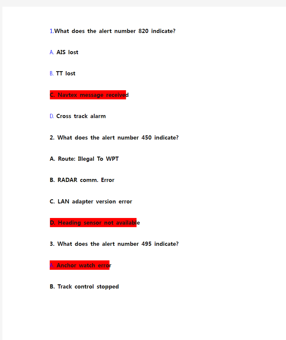
1.What does the alert number 820 indicate?
A. AIS lost
B. TT lost
C. Navtex message received
D. Cross track alarm
2. What does the alert number 450 indicate?
A. Route: Illegal To WPT
B. RADAR comm. Error
C. LAN adapter version error
D. Heading sensor not available
3. What does the alert number 495 indicate?
A. Anchor watch error
B. Track control stopped
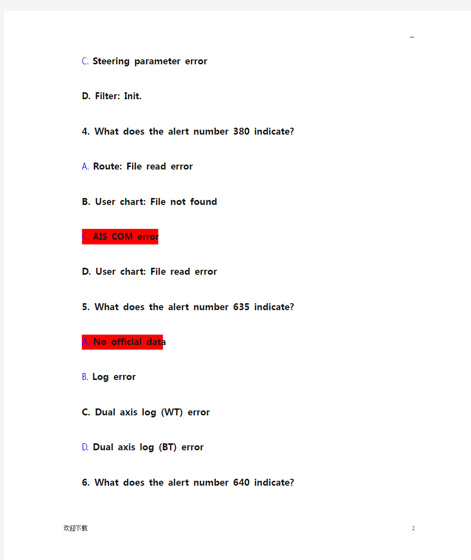
C. Steering parameter error
D. Filter: Init.
4. What does the alert number 380 indicate?
A. Route: File read error
B. User chart: File not found
C. AIS COM error
D. User chart: File read error
5. What does the alert number 635 indicate?
A. No official data
B. Log error
C. Dual axis log (WT) error
D. Dual axis log (BT) error
6. What does the alert number 640 indicate?
A. Datum mismatch
B. Chart align: Over 30 min.
C. RADAR antenna ID error
D. Gyro error (Trackpilot)
7. What does the alert number 031 indicate?
A. Sensor adapter 1 COM timeout
B. Sensor adapter 2 COM timeout
C. Sensor adapter 3 COM timeout
D. Sensor adapter 4 COM timeout
8. What does the alert number 257 indicate?
A. Heading sensor not available
B. Prg track: Need higher speed
C. Prg track: Use radius Ctrl
D. Gyro 3 COM error
9. What does the alert number 470 indicate?
A. WGS 84 not used
B. Different geodetic datum
C. Sentence syntax error
—
D. Datum change
10. Where do you control the settings and visibility of the chart layers?
A. In Chart Legend
B. In Symbol Display
C. In Chart Display
D. In Basic Setting
11. Where do you set the Safety Depth?
A. In Chart Legend
B. In Symbol Display
C. In Chart Alert
D. In Chart Display
12. Where do you set the Shallow Contour?
A. In Chart Legend
B. In Symbol Display
C. In Chart Alert
D. In Chart Display
13.Where do you set the Deep Contour?
A. In Chart Legend
B. In Symbol Display
C. In Chart Alert
D. In Chart Display
14.Where do you set the Safety Contour?
A. In Chart Legend
B. In Symbol Display
C. In Chart Alert
D. In Chart Display
15. Where do you set the Shallow Pattern?
A. In Chart Display
B. In Symbol Display
C. In Basic Setting
D. In Chart Catalogue
16. Where do you control the AIO?
A. In Chart Legend
B. In Symbol Display
C. In Chart Display
D. In Chart Catalogue
17.Where do you select the color Palette used to display the charts?
A. In Chart Legend
B. In Chart Display
C. In Quick Access Bar
D. In Chart Catalogue
18.Where do you switch between Multicolor and Two Color settings for the charts?
A. In Chart Legend
B. In Symbol Display
—
C. In Basic Setting
D. In Chart Display
19. When an ENC is outlined in Green in the Chart Catalogue - it means?
A. License is valid - chart is up-to-date.
B. License is valid - chart is NOT up-to-date.
C. License is available - chart not installed.
D. License is not available or has expired.
20. When an ENC is outlined in Orange in the Chart Catalogue - it means?
A. License is valid - chart is up-to-date.
B. License is valid - chart is NOT up-to-date.
C. License is available - chart not installed.
D. Cancelled chart.
21. When an ENC is outlined in Magenta in the Chart Catalogue - it means?
A. License is valid - chart is up-to-date.
B. License is valid - chart is NOT up-to-date
C. License is available - chart not installed
D. License is valid - up-to-date status doubtful.
22. When an ENC is outlined in Yellow in the Chart Catalogue - it means?
A. License is valid - chart is NOT up-to-date.
B. License is available - chart not installed.
C. License is valid - up-to-date status doubtful.
D. License is not available or has expired.
23. When an ENC is outlined in Red in the Chart Catalogue - it means?
A. License is valid - chart is NOT up-to-date.
B. License is available - chart not installed.
C. License is valid - up-to-date status doubtful.
D. License is not available or has expired
24. When an ENC is outlined in Blue in the Chart Catalogue - it means?
A. License is valid - chart is up-to-date.
B. License is valid - chart is NOT up-to-date.
C. License is available - chart not installed.
D. Cancelled chart.
25. Where can you find information concerning the charts stored on the HDD?
A. On the Internet.
B. The Chief Officer will know.
C. In the chart catalogue.
D. In the Chart Display menu.
26. How can you tell if your FURUNO ECDIS is displaying an ENC?
A. There is an "ENC Data available" indication in the Own Ship Functions Box.
B. There is an "RNC data" indication in the Own Ship Functions Box.
C. The FURUNO ECDIS will give an audible alarm if I am not viewing an ENC.
D. There is no special indication in the Own Ship Functions Box.
27. Where do you find information on Magnetic Variation in the ENCs on the FURUNO ECDIS?
A. In Chart Display
—
B In Chart Catalogue
C In Chart Alert
D In Chart Legend
28. Which information can you find in the Vector Chart Legend?
A Magnetic Variation
B Base CD number
C Permit expiration date
D Safety Contour setting
29. Which information can you find in the Vector Chart Legend?
A T&&P Notices
B Name
C Warnings
D Safety Contour setting
30. Which information can you find in the Vector Chart Legend?
A Notices To Mariners
B Presentation Library edition number
C Chart edition && Update date
D Safety Contour setting
31. Which information can you find in the Raster Chart Legend?
A Magnetic Variation
B Safety Contour setting
C Quality of data
D T&&P Notice
32.Which information can you find in the Raster Chart Legend?
A Horizontal datum
B Safety Depth
C User Permit number
D License number
33.Which information can you find in the Raster Chart Legend?
A Shallow Contour
B Chart Name
C Chart Viewing date
D Deep Contour
34. Which information can you find in the Raster Chart Legend?
A Edition number
B Last displayed update
C Edition date
D Update issue date
35. How do you switch from Vector chart to Raster chart on the FURUNO ECDIS?
A I select Raster chart in the Main menu.
B I select RN
C in the Chart Legend.
C I select Raster chart from the drop down list in the Status Bar.
D I select RNC in the Chart Catalogue.
36. How do you switch from Raster chart to Vector chart on the FURUNO ECDIS?
—
A I select ENC in the Main menu.
B I select Vector chart in the Chart Legend.
C I select Vector chart from the drop down list in the Status Bar.
D I select Vector chart in the Chart Catalogue.
37.How do you get information on an ENC object (Buoy - Beacon - Berth etc.) on the FURUNO ECDIS?
A I right click on the User Chart function in the route planning tool.
B I click on the Chart Info in the Instant Access Bar.
C I center click on the object.
D I right click on the object.
38 How do you record Own Ship's position on the ECDIS charts when you have a Range/Bearing observation from your RADAR?
A I cannot record own ship's position manually on the FURUNO ECDIS.
B I record LOP in the Record function of the Event Log.
C I press the [CTRL] && [ACQ/ACT] button on the Control Unit.
D I select [Record][Event Log] and [User Event] from the Instant Access bar and insert
the observation in the Record User Event window.
39 Which operation can you perform on the FURUNO ECDIS?
A I can record target ship's positions in the Voyage log automatically.
B I can record a position fix manually by using just one distance and one bearing.
C I can playback my past voyage track on the charts.
D I can send my Route Plan and User Chart and Notes to a FURUNO GPS for display on
the GPS.
40 Which operation can you perform on the FURUNO ECDIS?
A I can record my position manually on the ENCs.
B I can set the ECDIS to automatically choosing a Safety Contour based on my setting
of Ship's maximum draft.
C I can set Ship's maximum height to enable chart alerts from areas in the charts
where there is not sufficient air draft.
D I can send a copy of my Route Plan to an AIS target as a Safety Message.
41Which operation can you perform on the FURUNO ECDIS?
A I can play back my ship's past track on the ECDIS.
B I can record my position manually on the RNCs.
C I can create Notes from my Voyage Log to document a voyage on the charts.
D I can set the ECDIS to include engine log information into the Voyage log
automatically.
42How do you document your previous voyage on the FURUNO ECDIS?
A I use my paper Logbook as documentation.
B I use my paper Logbook and my VDR or SVDR as documentation.
C I use the tracking function in the symbol display.
D I show a playback of my past voyage track on the charts.
—
43 Which operation can you perform during a voyage?
A I can use the Event function to record special events in the Event Log.
B I can create a User Chart from the Alert Log and save it to a USB memory device.
C I can create a User Chart from the Chart Usage Log and save it to a USB memory
device.
D I can create a User Chart from the Voyage Log and save it to a USB memory device.
44Which operation can you perform during a voyage or after completion of a voyage?
A I can use the Event function to record special events in the Details Log.
B I can view and print a copy of the Voyage Log.
C I can create a backup copy of Own Ship's past track (120 minutes max.) on a USB
memory device and keep the copy in a safe location for future reference.
D I can reset the Chart Usage Log after creating a backup copy.
45Which operation can you perform during a voyage or after completion of a voyage?
A I can use the Record function to record special events in the Voyage Log.
B I can create and save a screen shot for future reference.
C I can view and print a copy of the Details Log.
D I can connect the ECDIS to the Internet and upload all documentation to an external
storage.
46Which operation can you perform after completion of a voyage?
A I can add additional records of manual positions to the Voyage Log adding further
detail to the past Voyage.
B I can create a User Chart from the monitored Route Plan and save it to a USB memory
device.
C I can create a backup copy of the Voyage log on a USB memory device.
D I can view and print a copy of the Chart Usage Log.
47Which recording function is available in the FURUNO ECDIS?
A Danger Targets Log
B Engine Log
C Speed Log
D GPS Log
48 Which recording function is available in the FURUNO ECDIS?
A AIS Log
B Engine Log
C Voyage Log
D RADAR Log
49Which recording function is available in the FURUNO ECDIS?
A Gyro Log
B Engine Log
C Ship's Log
D Details Log
50How do you manually record Own Ship's current position in the Logs?
A By opening the Voyage Log and entering the current position.
B By right clicking on own ship icon on the user interface.
C By pressing the Record button on the Control Unit.
—
D By using the record position event function of the Event Log.
51What is a Manual Update?
A A Manual update is an update applied using the Manual function in Load && Update
Charts.
B A Manual update is an update to the charts created by the operator from information
received from the Pilot - a Navtex message - a VHF broadcast etc.
C A Manual update is an update applied to the charts by an official representative
of the chart producer.
D A Manual update is a chart created using the digitizer function of the FURUNO ECDIS.
52How do you delete a specific object added using the Manual Update function?
A I select Clear in the Manual Update window.
B I use the Delete function in the File Export tool.
C I right click on the object and use the Manual Update window to delete it.
D I set the View Until date for the Manual Update two months back in time.
53How do you modify an existing Manual Update object?
A I use the ENC tab of the Chart Maintenance function.
B I use the Mariner tab of the Symbol Display function.
C I cannot modify a Manual Update - only delete it.
D I use the List tab of Manual Update tool function.
54How can you see if a chart object is created using Manual Updates?
A The Manual Update will be larger than any other chart objects.
B It is always shown in red.
C It will have a special orange marker.
D There is no way I can see if a chart object is created using Manual Updates.
55Which color scheme is used for a Manual update on the Furuno ECDIS?
A Blue ENC symbols
B Standard EN
C symbols
C Orange ENC symbols
D Red ENC symbols
56 Where can Manual Updates be displayed?
A Only on ENCs
B Only on RNCs
C Only on Vector charts
D On all types of charts in the ECDIS
57 Where can you find a list of the Manual Updates that have been applied to the Furuno ECDIS?
A In the Chart Legend
B In the Manual Update Window
C In the Chart Catalogue
D In the Chart Display menu
58How do you hide (not delete) a Manual Update object?
A I select Clear from the Manual Updates menu.
B I select Undo Last from the Manual Updates menu.
C I deselect that general type of chart object in the Chart Display dialogue.
—
D I deselect the option from the Symbol Display dialogue.
59Which Manual Update objects can be hidden from view by operator selection?
A Only the Manual Updates Special Areas (from the Chart Display dialogue)
B All manual Updates objects(from the Chart Display dialogue)
C Only the Manual Updates Buoys (from the Chart Display dialogue)
D Only the Manual Updates Soundings (from the Chart Display dialogue)
60 Can you create a Manual Update from an AIS Safety Message shown on the ECDIS?
A Yes - by manually creating the object.
B Yes - by letting the ECDIS create the object automatically.
C Yes - either by creating it manually or letting the ECDIS create it automatically.
D No
61Can you create a Manual Update from a Navtex Message shown on the ECDIS?
A Yes - by manually creating the object.
B Yes - by letting the ECDIS create the object automatically.
C Yes - either by creating it manually or letting the ECDIS create it automatically.
D No
62Where do you change the visibility of your Monitored route?
A In Chart Legend
B In Symbol Display
C In Chart Display
D In Chart Catalogue
63Where can you update the ENCs?
A In the Chart Manager (Individual Update)
B In the Update function of the Chart Display
C In the Update function of the System Settings
D In the Update function of the Chart Legend
64Where can you update the RNCs on the Furuno ECDIS?
A In the Update function of the Menu
B In the Chart Manager (Individual Update)
C In the Update function of the Chart Catalogue
D In the Update function of the Chart Legend
65How do you update your vector charts on the Furuno ECDIS using the ENC Update CD?
A I use the AutoLoad function.
B I create a Manual Update from the information on the CD.
C I create a User Chart.
D I import the information using the Chart Details function in the Chart Catalogue.
66How are regular T&Ps updated on the ECDIS?
A T&&Ps must always be created as Manual Updates.
B I create a Manual Update containing the T&&Ps using the Manual function in the
Load && Update function of the Chart Menu.
C Most T&&Ps are included in the weekly update C
D and these are updated automatically
together with the other updates on the CD.
D I cannot update T&&Ps on the FURUNO ECDIS.
67How do you update your raster charts on the Furuno ECDIS using the RNC Update CD?
—
A I use the AutoLoad function.
B I create a Manual Update from the information on the CD.
C I cannot update the raster charts using an RNC update CD.
D I import the information using the Chart Details function in the Chart Catalogue.
68How are loaded ENCs converted into SENCs when updating?
A The FURUNO ECDIS will normally convert the ENCs to SENCs automatically.
B I must use the conversion tool from the Menu.
C I cannot convert ENCs into SENCs.
D I load the new Permit file using the file named ENC.PMT and then I use the S52
Presentation Library from the System menu in the Chart Menu to convert the ENCs
into SENCs.
69What is the recommended loading sequence when you receive new charts - updates and permits?
A There is no recommended sequence.
B #1:Base CDs #2:Update CD #3:Permit
C #1:Permit #2:Update C
D #3:Base CDs
D #1:Permit #2:Base CDs #3:Update CD
70How do you select which User Chart to monitor?
A By linking it to the monitored Route Plan in the route planning tool.
B By clicking Display - User Chart in the Quick Access Bar.
D By left clicking on the chart area.
71Where can you enter informative notes on Pilot data (VHF channels etc.) to be used during monitoring in the FURUNO ECDIS?
A In the Voyage Log
B In the Pilot Data
C In the User Event function
D In the User Chart
72How do you enter informative notes in the User Chart?
A I select Note as an option for the Area Line or Circle where the information should
be displayed.
B I select Note as an option for the Tidal Label or Clearing Line where the information
should be displayed.
C I select User Chart from the Main menu and then I select Plan and enter the note
to be displayed.
D I left click on Route in the Quick Access Bar and then I select Monitor.
73How do you change the User Chart being used for monitoring?
A I move the monitored route plan to planning mode and edit the Linked User Chart
setting.
B I select a different user chart from the Menu to monitor.
C I select User Chart from the Planning sidebar and then I select Monitor for the
desired user chart.
D I left click on User Chart in the Status Bar and then I select Plan.
74Can you move your User Chart from one FURUNO ECDIS to another?
A No
—
B Yes but only by using the harmonization process.
C Yes by using the Export/Import tool in the Settings function of the Status Bar.
D Yes but only to an ECDIS with the exact same software version number.
75Which printing option is available for the User Chart?
A Tidal Report
B Full report
C System report
D Detailed report
76Which printing option is available for the User Chart?
A Full report
B Line Report
C System report
D Detailed report
77Which printing option is available for the User Chart?
A Full report
B System report
C Clearing Line Report
D Detailed report
78Which printing option is available for the User Chart?
A Full report
B System report
C Detailed report
D Area Report
79 Which printing option is available for the User Chart?
A Circle Report
B Full report
C System report
D Detailed report
80Which printing option is available for the User Chart?
A Label Report
B Full report
C System report
D Detailed report
81Where can you display your planned or monitored User Chart on the FURUNO ECDIS?
A Only on official charts
B On all charts
C Only on vector charts
D Only on raster charts
82How can you verify which User Chart is being monitored?
A The name of the User Chart will be displayed in the top right corner of the ECDIS
screen.
B The name of the User Chart will be displayed in the Information Sidebar.
C By clicking on "Route" and then on "Route Info" in the Quick Access Bar when in
Plan mode.
—
D By clicking on "Route" and then on "Route Info" in the Quick Access Bar when in
Navi mode.
83What is the name of category of charts generated by the user to draw up contingency
areas - No Go areas - clearing lines etc.?
A Private Chart
B Pilot Data
C User Chart
D Non HO Chart
84How do you open the User Chart planning tool?
A I select "Planning" and then "User Chart" in the Quick Access bar when in Plan
mode.
B I select "Planning" and then "User Chart" in the Quick Access bar when in Navi
mode.
C I Select Manual Update from the Menu in Charts mode.
D I left click on User Chart in the Information sidebar - then I select Plan.
85Can you edit the User Chart when the ECDIS is in Navi mode?
A Yes
B Only if the User Chart is not linked to a route plan.
C Yes if the User Chart contains no Tidal information.
D No
86What is a Point in the User Chart?
A A point is used to create a Manual Update from a chart object.
B A point is used to denote/highlight the position of a chart object with the User
Chart.
C A point is the end of a User Chart.
D A point is used to connect the User Chart with a route plan.
87 Can you copy your Manual Updates from one FURUNO ECDIS to another?
A No
B >Yes - by using the Backup and Restore dialogue to transfer the Manual Updates
to a USB.
C Yes - by sending the Manual updates via an email.
D No - but I can transfer them to another manufacturer's type of ECDIS.
88 When do you use a Manual Update?
A Always when I have to update my charts.
B When I receive information which must be displayed on my ECDIS and this is not
yet included in the official weekly updates.
C I should never use Manual Updates.
D >When I have to update the software of the ECDIS.
89 How do you add navigational chart objects to the FURUNO ECDIS when you are required
to do so by Notices To Mariners?
A I cannot add any chart objects to the ECDIS unless they are included in the weekly
update CDs.
B I use the Manual Updates function.
C I use the User Chart function.
—
D I use the Chart Edit function.
90 How do you add navigational chart objects to the FURUNO ECDIS when you are required
to do so by a Navtex message?
A I cannot add any chart objects to the ECDIS unless they are included in the weekly
update CDs.
B I use the Manual Updates function.
C I use the User Chart function.
D I use the Chart Edit function.
91 How do you add navigational chart objects to the FURUNO ECDIS when you are required
to do so by information received via VHF broadcast?
A I cannot add any chart objects to the ECDIS unless they are included in the weekly
update CDs.
B I use the Manual Updates function.
C I use the User Chart function.
D I use the Chart Edit function.
92 How can you verify which route is being monitored?
A The name of the route will be displayed on my own ship vector.
B The name of the route will be displayed in the Route Information box.
C By right clicking on own ship icon.
D I cannot get information on the route which is being monitored.
93 How can you verify which route is being monitored?
A By clicking on "Route" and then on "Route Info" in the Quick Access Sidebar in
Plan mode.
B The name of the route will be displayed in the Status Bar.
C By clicking on "Route" and then on "Route Info" in the Quick Access Sidebar in
Navi mode.
D I cannot get information on the route which is being monitored.
94 Can you monitor a route even though it indicates an active Alert when you have completed
the Route Plan Check?
A Yes - the only thing preventing me from monitoring would be an Impossible Turn
message in the WPT tab.
B Yes - if I enter the Service Safety Password.
C No
D It depends on the type of Alert generated (Safety Contour - Restricted Area - Caution
Area etc.).
95 What should you remember to set up before planning a route?
A The settings for the Voyage Log
B The Alarm Level in the Operation submenu.
C The Conning Display in Installation Parameters.
D The Chart Viewing Dates
96 What should you remember to set up first when planning a route?
A The settings for the Voyage Log
B The Alarm Level in the Operation submenu
C The Safety Contour in the route planning tool
—
D The Radar overlay
97 How do you save your route to the Hard Disc Drive when it has been edited?
A I don't. The route is automatically saved to the hard disc drive whenever changes
are applied.
B I click on Save or Save As in the Route Planning tool.
C I select Save in the Backup and Restore dialogue.
D I click New in the Route Planning tool.
98 How do you start the route planning tool?
A I press Plan on the Control Unit.
B I click on the Route icon in the Status bar.
C I select Route Plan from the Menu dialogue.
D I click on Route in the Quick Access bar.
99 Can you open the route planning tool when the ECDIS is in Chart mode?
A Yes if I open the Menu dialogue first.
B Yes if I right click on the chart and select Event.
C Yes if I select Plan in the Chart Catalogue.
D No
100 Where do you set up the Safety Contour used for planning your route?
A On the Parameters tab of the Route Planning tool.
B In Chart Display
C In Chart Alert settings
D In Own Ship settings
101 Can you set the overall maximum speed for a route plan?
A Yes in the Ship and Route parameters of the Menu.
B Yes in Chart Display.
C Yes in Optimization parameters.
D Yes in the route planning tool.
102 Can you plan a route while you monitor another route?
A No
B Yes but only if I have two ECDIS.
C Yes the route planning function is independent from the route monitoring function.
D Yes but I must select the same Safety Contour for both route plans.
103 Can you edit a route without removing it from the route monitoring function?
A No
B Yes but I must copy it to another ECDIS where it can be edited without interfering
with the monitoring function of the FURUNO ECDIS.
C Yes if I create a copy of the route plan in ANTS format on a USB and edit the file
on a normal office PC.
D Yes if I select Copy from monitor in the Route plan menu and edit the copy. When
copying is completed I select-Exchange with monitor in the Route Plan menu.
104 Which operation can you perform with the FURUNO ECDIS?
A I can send my Route Plan and User Chart to any RADAR for display on the RADAR.
B I can send my Route Plan and User Chart to any AIS for display on the AIS.
C I can send my Route Plan and User Chart to any GPS for display on the GPS.
—
D I can send my Route Plan and User Chart to a FURUNO RADAR for display on the RADAR.
105 Where can you change the setting of the Safety Contour which is used during planning
of a route?
A Nowhere - because I must never change the setting for the Safety Contour.
B In the Settings menu and I can only change the setting if I have the service password.
C In Chart Alert
D In the route planning tool.
106 Where can you change the settings for the Safety Contour used for monitoring?
A Nowhere - because I must never change the setting for the Safety Contour.
B In the Settings menu and I can only change the setting if I have the service password.
C In Chart Alert.
D In the route planning tool.
107 Where do you control the Safety Contour displayed on the Charts on the FURUNO ECDIS?
A In Chart Alert
B In the route planning tool - on the Alerts tab
C In Chart Display
D No where - it is set up automatically
108 What is Kalman filter in the FURUNO ECDIS?
A The Kalman Filter is a noise filter which improves the precision of the charts.
B The Kalman filter is a filter which reduces the time it takes for the ECDIS to
start up.
C The Kalman Filter is a filter which continuously monitors the status and validity
of the navigation sensor inputs.
D The Kalman Filter is a filter which continuously monitors the connection to the
RADAR GPS and AIS.
109 Which of these settings generate an alarm from the Chart Alert setting?
A Shallow Contour
B Safety Depth
C Safety Contour
D Deep Contour
110 Which ECDIS setting is activated in Ship and Route Parameters?
A Gyro Error
B Safety Contour
C Notes alarm times
D Ship's minimum speed
111 Which ECDIS setting is adjusted in Ship and Route Parameters?
A Chart alignment
B Safety Contour
C Maximum rate of turn
D Safety depth
112 Which ECDIS setting is adjusted in Ship and Route Parameters?
A Position offset
B Safety Contour
C Alarm volume
—
D Ship's maximum speed
113 Where do you set up the chart watch sector to scan the ENCs for problems along own
ship's heading line?
A In Chart Display settings
B In Chart Alert settings
C In Basic settings
D In Check Area settings
114 What is the maximum limit of the Check Area?
A No limit
B 240min. + 20NM + 5km + 999m
C 120min. + 10NM + 3km + 500m
D
115 What should you do if you have to leave your planned route during a voyage?
A Switch off the FURUNO ECDIS and concentrate on the RADAR.
B Disable the route monitoring on the FURUNO ECDIS.
C Change the display of the FURUNO ECDIS to IMO All Other.
D Configure and enable the Check Area function to assist me in scanning the ENCs
for danger to navigation and hazardous objects.
116 How do you switch the Kalman filter on or off?
A The Kalman filter is always switched on when a route is put into monitor mode and
switched off when there is no route being monitored
B The Kalman filter is always on so I never have to switch it on or off.
C The Kalman filter is switched on or off in the Sensor menu on the Position tab.
D The Kalman filter is switched on when steering is switched to Autopilot.
117 If your primary GPS fails - how do you switch to another position sensor in the FURUNO ECDIS?
A I cannot switch to another position sensor - a service technician is required to
make the switch.
B The ECDIS will normally switch to the secondary position sensor automatically if
such is connected to the ECDIS.
C I change the position sensor in the Initial Settings submenu.
D I change the position sensor in the Conning Display.
118 If your primary GPS fails - how do you switch to another position sensor in the FURUNO ECDIS?
A I cannot switch to another position sensor - a service technician is required to
make the switch.
B I change the position sensor in the Chart Display dialogue.
C I change the position sensor in the Sensor dialogue of the Menu.
D I change the position sensor in the Conning Display dialogue.
119 What is the purpose of Kalman Filter?
A The Kalman Filter is the Antivirus software running on the FURUNO ECDIS.
B The filter is used to calculate an astronomical position from several astronomical
observations entered by the operator.
—
C The filter continuously monitors the position given by each individual position
sensor to determine if the sensor is reliable or not.
D The filter is used to verify the quality of data on the Base and Update CDs.
120 How can you reset the trip counter?
A I can reset the Trip Counter by resetting the Voyage Log in the Reset submenu of
the Record menu.
B I can reset the Trip Counter by resetting it in the Voyage tab of the Menu.
C I cannot reset the Trip Counter.
D The Trip Counter can be reset by deleting it using the Backup and Restore dialogue.
121 How can you reset the odometer?
A I can reset the odometer from the Voyage tab of the Menu.
B I can reset the odometer from the Sensor Setting dialogue.
C I can reset the odometer from the Symbol Display dialogue.
D I can reset the odometer from the Quick Access sidebar.
122 Where do you offset own ship chart position on the FURUNO ECDIS?
A In Symbol Display
B In Chart Display
C In Chart Menu
D In own ship functions box
123 Where do you set system priority of multiple GPS connected to the FURUNO ECDIS?
A In the Sensor dialogue
B In Basic Setting
C In Ship and Route Parameters
D In Nav Tools
124 Which setting can be changed in Sensors?
A Log stabilization mode
B Safety Contour setting
C Safety Depth setting
D Kalman Filter setting
125 Which setting can be changed in Sensors?
A Monitored sensors
B System or Local selection
C Symbol Display setting
D Conning Display setting
126 When the software of the FURUNO ECDIS is being updated - it is important that?
A The multiple GPS connected to the ECDIS are updated with the new software version.
B That it is done when the ECDIS is not being used for navigation (in port etc.).
C The HUBs connected to the ECDIS are updated with the new software version.
D The RADAR connected to the ECDIS is not being used (in port etc.).
127 When the software of the FURUNO ECDIS is being updated - it is important that?
A The software is updated by a FURUNO Service Engineer.
B The software is updated by the Captain.
C The software is updated by the Ship's Electrical Engineer.
D The software is updated by an IMO representative.
—
128 When the software of the FURUNO ECDIS is being updated - it is important that?
A The software should be loaded from a US
B memory device.
B The FURUNO ECDIS is put in Standby mode before updating.
C You create backup copies of all critical info in the ECDIS before updating.
D The ECDIS is disconnected from the RADAR.
129 Where do you find information on the presentation library used in the FURUNO ECDIS?
A In the Basic Setting of the Menu
B In the Record function of the Quick Access bar
C In the System Dialogue of the Menu
D In the About dialogue
130 Where do you find information on the software version of the FURUNO ECDIS?
A In the Voyage Log
B In the System dialogue of the Menu
C In the About dialogue
D In the S52 Presentation library
131 Which Operating System is used on the FURUNO ECDIS?
A Linux
B DOS
C Windows XP
D Windows 8
132 Where do you find information on the Conning software version of the FURUNO ECDIS?
A In the Voyage Log
B In the System dialogue of the Menu
C In the About dialogue
D In the S52 Presentation library
133 Where do you find information on the C-Map SDK (Software Developers Kit) software version of the FURUNO ECDIS?
A In the Voyage Log
B In the System dialogue of the Menu
C In the About dialogue
D In the S52 Presentation library
134 Where do you control the visibility of the user overlays (User Chart - Route - etc.)?
A In Chart Legend
B In Symbol Display
C In Chart Display
D In Chart Catalogue
135 Where do you change the display of Own Ship Past Track and other user overlays?
A In the Information Sidebar
B In Chart Display
C In Symbol Display
D In the Status Bar
136 Where do you change the Velocity Vectors style?
A In the Quick Access bar
B In Chart Display
—
C In Symbol Display
D In the Status Bar
137 Where do you change the Ship Outlines?
A In the Quick Access bar
B In Chart Display
C In Symbol Display
D In the Status Bar
138 Where do you change the Target past position density?
A In the Quick Access bar
B In Chart Display
C In Symbol Display
D In the Status Bar
139 Where do you change the Targets color?
A In the Quick Access bar
B In Chart Display
C In Symbol Display
D In the Status Bar
140 Where do you change the Tracked Target size?
A In the Quick Access bar
B In Chart Display
C In Symbol Display
D In the Status Bar
141 Where do you change the visibility of your Circles?
A In Chart Legend
B In Symbol Display
C In Chart Display
D In Chart Catalogue
142 Where do you change the visibility of your User Chart?
A In Chart Legend
B In Symbol Display
C In Chart Display
D In Chart Catalogue
143 Where do you change the visibility of your Planned route?
A In Chart Legend
B In Symbol Display
C In Chart Display
D In Chart Catalogue
AWENA-1型船载电子海图系统(ECS) AWENA-1船载型电子海图系统(ECS)(前生AWENA-1船舶智能导航仪)是电子航行参考图显示系统(IHO S-57)和船舶智能避碰系统综合应用开发具有完全知识产权的新型船舶助导航产品,符合中国海事局《国内航行船舶船载电子海图系统(ECS)功能、性能和测试要求(暂行)》中的A级设备要求。能有效改善船舶航行的安全性,自动判别周围船舶的多种航行信息,结合电子航行参考图显示系统,实现了航行信息综合显示和智能辅助导航。 ?产品特点: 1. 本机采用模块化设计,以电子海图系统(ECS)为基本显示平台,与各导航传感器的合适组合构成了一套完整的,精确的,综合定位系统,并提供先进的,便捷的最佳化定位功能,有利于安全航行,触摸式的系统操作,更人性化。 2. 具有完全的自主知识产权全中文电子航行参考图显示平台,以S-52标准进行显示国际标准(IHO S-57)的电子海图,具有航线设计功能,并可在图上设置本船安全等深浅和安全水深,并突出显示。 3. 系统可接收处理AIS、GPS、罗经、测深仪、计程仪等设备的输入信息,给出与本船航行有关的周围动态交通状况显示,在航路监视同时,综合分析发生各类碰撞、搁浅、误入禁止区等危险的可能,提前警告,并试验解决途径,提供驾驶员安全规避的操作方案。 4.报警功能:监视各种航行危险并智能计算周围船舶的航行信息,为
船舶提示最危险的航行船舶:到达(接近)转向点指标,超出航迹偏移极限,越过安全等深浅,搁浅危险,接近孤立危险物,接近禁止区域,定位传感器故障等,都会报警。CPA/TCPA计算及报警(声光报警)。 5. 航迹记录:系统记录最近本船12小时内每分钟的实际航迹,可保 存最近3个月的本船实际航迹的独立航行记录。 6、提供国家海事局官方出版的电子海图预安装服务,同时也提供国 家海事局官方提供的电子海图升级安装服务(服务收费)。国家海事局官方出版的电子海图包含国内沿海和长江电子海图数据.海图信息包含的海图版本号,生产日期和套数号码,每套海图数据只能安装该条船只,船检也将对应船只进行相关信息的检查。 7提供用户、上海海事局航海图书印制中心和上海埃威航空电子有限公司三方共同签订提供电子海图数据的相关协议.上海埃威航空电子有限公司将签订的相关信息提供给国家海事局海图出版中心备案。 8. 在签订电子海图预安装服务(服务费1000元)和三方协议后,海 埃威航空电子有限公司将预先安装国家海事局官方出版的电子海图包含国内沿海和长江电子海图数据.用户可以在中国海事电子海图发行网站注册登记网址为(.10/chart),并可获得用户名\密码,免费下载相关的海图更新数据.同时也可以选择由上海埃威航空电子有限公司提供的一季度一次的海图数据升级光盘服务(有偿),保证相关海图数据产品源于官方正规渠道。
单选题(目前72个,未完待续) 1.how do you get information on an ENC object(buoy-beacon-berth etc)on the FURUNO ECDIS? A.I right click on the use chart function in the route planning tool. B.I click on the chart info in the instant access bat C.I enter click on the object. D.I right click on the object 估计答案:D 正确答案: 2.where can you find a list of the manual updates that have been applied to the FURUNO ECDIS? A.in the chart legend
B.In the manual update window C.In the chart catalogue D.In the chart display menu 估计答案:B 正确答案: 3.how can you see if a chart object i cteated using manual updates? A.the manual update will be larger than any other chart objects B.It is always shown in red C.It will have a special orange marker D.There is no way i can see if a chart object is created using manual updates 估计答案:C 正确答案: 4.How do you add navigation chart objects to the FURUNO ECDIS when you are require to do so by notices to mariners? A.i can not add any chart objects to the ECDIS unless they are included in the weekly update B.I use the manual update function C.I use the user chart function
1. Which operation can you perform on the FURUNO ECDIS? ( B ) a. I can play back my ship’s past track on the ECDIS b. I can record my position manually on the RNCs. c. I can create Notes from my Voyage Log to document a voyage on the charts. d. I can set the ECDIS to include engine log information into the Voyage Log automatically. 2. Which operation can you perform on the FURUNO ECDIS? ( A ) a. I can record my position manually on the ENCs. b. I can set the ECDIS to automatically choosing a Safety contour based on my setting of ship’s maximum draft. c. I can set Ship’s maximum height to enable chart alerts from areas in the charts where there is not sufficient air draft. d. I can send a copy of my Route Plan to an AIS target as a Safety Messag e. 3. Which operation can you perform on the FURUNO ECDIS? ( C ) a. I can record target ship’s position in the Voyage log automatically. b. I can record a position fix manually by using just one distance and one bearing. c. I can playback my past voyage track on the charts. d. I can send my Route Plan and User Chart to a FURUNO GPS for display on the GPS. 4. Which operation can you perform with the FURUNO ECDIS? ( D ) a. I can send my Route Plan and User Chart to any RADAR for display on the RADAR. b. I can send my Route Plan and User Chart to any AIS for display on the AIS. c. I can send my Route Plan and User Chart to any GPS for display on the GPS. d. I can send my Route Plan and User Chart to a FURUNO RADAR for display on the RADAR. 5. Which operation can you perform during a voyage? ( A ) a. I can use the Event function to record special events in the Event Log. b. I can create a User Chart from the Alert Log and save it to a USB memory device. c. I can create a User Chart from the Chart Usage Log and save it to a USB memory device. d. I can create a User Chart from the Voyage Log and save it to a USB memory devic e. 6. Which operation can you perform after completion of a voyage? ( D ) a. I can add additional records of manual positions to the Voyage Log adding further details to the past voyage. b. I can create a User Chart from the monitored Route Plan and save it to a USB memory device. c. I can create a backup copy of the Voyage log on a USB memory device. d. I can view and print a copy of the Chart Usage Log. 7. Which operation can you perform during a voyage or after completion of a voyage? ( B ) a. I can use the Event function to record special events in the Details Log. b. I can view and print a copy of the Voyage Log. (或更换为Details Log) c. I can create a backup copy of Own Ship’s past track (120 minutes max.) on a USB memory device and keep the copy in a safe location for future reference. d. I can reset the Chart Usage Log after creating a backup copy. 8. What is a Manual Update? ( B ) a. A Manual Update is an update applied using the Manual function in Load & Update Charts. b. A Manual Update is an update to the charts created by the operator from information received from the Pilot – a Navtex message – a VHF broadcast et c. c. A Manual Update is an update applied to the charts by an official representative of the chart
第一章电子海图与电子海图系统 第一节电子海图与标准电子海图 随着计算机技术与航海技术的不断发展,产生了以数字形式表示的海图以及各种电子海图应运系统。它们的出现是水道测量领域的一场新技术革命,使海图研究,生产以及使用跨入了一个新的纪元,也促使航海自动化迈上新的台阶。 所谓的电子海图(Electronic chart, EC)是在显示器上显示出海图信息和其他航海信息,所以也称“屏幕海图”。电子海图及其应用环境组成电子海图系统。 一、电子海图 电子海图是描述海域地理信息和航海信息的数字化产品,主要涉及海洋及其毗邻的陆地。详细的描述了岸形、岛屿、礁石、浅滩、沉船、水深、地质、助航标志、潮流、海流等航海所需的资料。 电子海图按照制作方法可分为矢量电子海图和光栅电子海图两大类。 (一)矢量电子海图(Vector Charts) 以矢量形式表示的数字海图。海图中的每个要素是以点、线、面等几何图形的形式存储在电子海图数据文件中、具有存储小、显示速度快、精度高、支持智能化航海等优点。用户查询电子海图中任意图标的细节(如灯标、颜色、周期)可根据需要有选择的显示不同的层次信息(如只显示小于10M的水深点)。矢量电子海图与其他的船舶系统相结合,能提供警戒区、危险区等自动报警功能。矢量电子海图被称为“智能电子海图”。 (二)光栅电子海图(Raster Charts) 以光栅形式表示的数字海图,通过对纸质的海图的一次性扫描,形成单一的数字信息文件;以像素的排列反映海图中的要素,依靠眼睛识别航海要素。因此,光栅电子海图被认为是纸质海图的复制品,它包含的信息(如岸线、水
深等)如纸质海图一一对应。光栅电子海图也可与定位传感器(如GPS)连接,但由于光栅电子海图制作原理上的局限性,光栅电子海图不能够提供选择性的查询和显示功能(如查询某一海图要素特征,或隐去某类海图要素特征等)。光栅电子海图被称为“非智能电子海图”。 目前,电子海图以矢量电子海图为主,光栅电子海图是在没有矢量电子海图的海域作为补充使用。 二、标准的电子海图 随着电子海图的发展,相关国际组织通过制定标准规范和统一的电子海图的数据格式,随之产生了标准的光栅电子海图和矢量电子海图,即光栅扫描航海图和电子航海图。 (一)光栅扫描航海图(Raster Navigational Chart, RNC) 符合国际水道测量组织(IHO)《光栅海图产品规范》S-61的光栅电子海图,是通过国家水道部或国家水道部授权出版的海图数字扫描而成,并与显示系统结合提供连续的自动定位功能的电子海图。 RNC具有以下属性: (1)由官方纸质海图复制而成; (2)根据国家标准制作; (3)内容的保证由发行数据的水道测量局负责; (4)根据数字化分发的官方改正数据进行定期改正。 RNC通常用于单一的海图或海图集的一些标准中。目前世界上主要的光栅扫描航海图产品有英国水道测量局(UKHO)生产的ARCS和美国国家海洋和大气管理局(NOAA)生产的RNC等。
故障代码类: 1. 031:sensor adapter 2 COM timeout 2. 257:Gyro 3 com error 3. 380:AIS COM ERROR 4. 450:heading sensor not available 5. 470:datum change 6. 495:anchor watch error 7. 635:no official data 8. 640:chartalign:over 30 min 9.820:navtex message received 考点(题中穿插): 1.DISP SETTING(chart watch sector) 2.Basic setting:shallow pattern Chart disp:AIO Symbol disp:magnetic variation Chart alert:shallow contour,safety depth,safety contour, deep contour 3.GREEN:license ok,chart is up-to-date ORANGE:license is valid,but not up-to-date
Magenta:license is valid,but not loaded to the ECDIS YELLOW:license ok,up-to-date status doubtful RED:not available or expired BLUE:canceled chart 单选题(目前72个,未完待续) 1.how do you get information on an ENC object(buoy-beacon-berth etc)on the FURUNO ECDIS? A.I right click on the use chart function in the route planning tool. B.I click on the chart info in the instant access bat C.I enter click on the object. D.I right click on the object 估计答案:D 正确答案: 2.where can you find a list of the manual updates that have been applied to the FURUNO ECDIS? A.in the chart legend B.In the manual update window C.In the chart catalogue D.In the chart display menu
电子海图详细手册 HEN system office room 【HEN16H-HENS2AHENS8Q8-HENH1688】
英国船商有限公司 电子海图显示与信息系统 (Navi-Sailor 2400 ECS/ECDIS) 操作手册 二OOO年七月 S E T S T H E S T A N D A R D 1.1介绍及注意事项 1.1.1版权 TRANSAS MARINE 是英国船商有限公司的注册商标。 NAVI-SAILOR是船商公司电子海图产品的注册商标。 软件版权在公司产品许可证中有规定,本手册属于船商公司产品,没有船商公司书面许可,不得复制及转载。 1.1.2 电子海图使用注意事项 Navi-Sailor 2400 ECDIS(以下简称NS)应当与国家航道测量局公布的S57格式的海图配合使用,并且根据航道测量局的要求及时更新。 如果NS使用其它格式的海图,则应注意以下几点: 船商生产的格式海图不是为了替代官方的海图。船商海图无需包括最新的更新,只有与官方纸海图配合才能使用。 屏幕上显示的船位只是坐标的图形指示,实际船位要依靠与定位传感器如GPS连接。 在使用NS进行航线设计前,首先应使用适当比例尺的纸海图,并依据最新航海通告进行更新。 在将纸海图的其它数据转换到NS时,应首先注意纸海图数据和船商海图使用的WGS-84数据的可能差别。 1.2如何使用用户手册 1.2.1用户手册简介及目的 本手册的编排能使用户方便地找到所需信息,包含以下几部分: 1.简介 2.NaviSailor系列软件的基本功能及使用界面介绍 3.NaviSailor各功能详细介绍 4.附录 5.NaviSailor软件"技术参考"手册简要介绍了NS系统的各个功能,并提供了 各菜单功能的索引 1.2.2本手册对操作描述方式的解释
1.What does the alert number 820 indicate? A. AIS lost B. TT lost C. Navtex message received D. Cross track alarm 2. What does the alert number 450 indicate? A. Route: Illegal To WPT B. RADAR comm. Error C. LAN adapter version error D. Heading sensor not available 3. What does the alert number 495 indicate? A. Anchor watch error B. Track control stopped C. Steering parameter error D. Filter: Init. 4. What does the alert number 380 indicate? A. Route: File read error B. User chart: File not found C. AIS COM error D. User chart: File read error 5. What does the alert number 635 indicate? A. No official data B. Log error C. Dual axis log (WT) error D. Dual axis log (BT) error 6. What does the alert number 640 indicate? A. Datum mismatch B. Chart align: Over 30 min. C. RADAR antenna ID error D. Gyro error (Trackpilot) 7. What does the alert number 031 indicate? A. Sensor adapter 1 COM timeout B. Sensor adapter 2 COM timeout C. Sensor adapter 3 COM timeout D. Sensor adapter 4 COM timeout 8. What does the alert number 257 indicate? A. Heading sensor not available B. Prg track: Need higher speed C. Prg track: Use radius Ctrl D. Gyro 3 COM error 9. What does the alert number 470 indicate? A. WGS 84 not used B. Different geodetic datum C. Sentence syntax error
NS3000电子海图简明使用手册 字体: 小中大| 打印发表于: 2010-12-14 12:51 作者: landho 来源: 海员联盟 1.通用操作说明 Navi Sailor 3000电子海图系统运行在Windows NT下,符合Windows应用软件的标准,很多操作风格都和其他windows应用软件相似,现加以说明: 1.1 右下角的主菜单的各菜单项,,除”Ahead”,”Review”,”ERBL”,”Zoom”,”Event”,”Info”即前两排菜单外,均为按钮选择型。当点击该菜单项时,海图区的下部则会出现该菜单项的详细窗口,用户可在其中选择具体的操作,这时该菜单项呈白色,表示该按钮已按下。如果要关闭该菜单,可再点击一下即可关闭。若要选择其他菜单项,可直接点击该菜单项,若该菜单为白色,表示您在之前已对该菜单作过操作,并保存着当时的状态。您只需点击屏幕左下角标记该菜单名称的一项,即可切换到该菜单项的具体操作。这样您可同时打开多个菜单,并可在菜单之间切换,方便了用户的操作。 1.2 系统屏幕中快捷按钮: 在海图的右边有一竖排快捷按钮,用户可以在操作电子海图的任何时刻点击快捷按钮进行相应的操作,当把光标移动到按钮上时会有该按钮的操作功能说明。 1.3 UTC和Local Time之间的切换,点击右上角当前时间左边时钟形状的按钮,即可在UTC和Local Time之前切换,并会有相应的提示。UTC和Local Time及时区的设置,是在Config->Time Zone中进行设置。 2.本手册缩略语 NS - NaviSailor 船商NaviSailor系列电子海图系统 App. - Appendix 附录
故障代码类: 1.031:sensor adapter2COM timeout 2.257:Gyro3com error 3.380:AIS COM ERROR 4.450:heading sensor not available 5.470:datum change 6.495:anchor watch error 7.635:no official data 8.640:chartalign:over30min 9.820:navtex message received 考点(题中穿插): 1.DISP SETTING(chart watch sector) 2.Basic setting:shallow pattern Chart disp:AIO Symbol disp:magnetic variation Chart alert:shallow contour,safety depth,safety contour, deep contour 3.GREEN:license ok,chart is up-to-date ORANGE:license is valid,but not up-to-date Magenta:license is valid,but not loaded to the ECDIS YELLOW:license ok,up-to-date status doubtful RED:not available or expired
BLUE:canceled chart 单选题(目前72个,未完待续) 1.how do you get information on an ENC object(buoy-beacon-berth etc)on the FURUNO ECDIS? A.I right click on the use chart function in the route planning tool. B.I click on the chart info in the instant access bat C.I enter click on the object. D.I right click on the object 估计答案:D 正确答案: 2.where can you find a list of the manual updates that have been applied to the FURUNO ECDIS? A.in the chart legend B.In the manual update window C.In the chart catalogue D.In the chart display menu 估计答案:B 正确答案: 3.how can you see if a chart object i cteated using manual updates? A.the manual update will be larger than any other chart objects B.It is always shown in red C.It will have a special orange marker
AWENA-1船载型电子海图系统(ECS) AWENA-1船载型电子海图系统(ECS)(前生AWENA-1船舶智能导航仪)是电子航行参考图显示系统(IHO S-57)和船舶智能避碰系统综合应用开发具有完全知识产权的新型船舶助导航产品,符合中国海事局《国内航行船舶船载电子海图系统(ECS)功能、性能和测试要求(暂行)》中的A级设备要求。能有效改善船舶航行的安全性,自动判别周围船舶的多种航行信息,结合电子航行参考图显示系统,实现了航行信息综合显示和智能辅助导航。 产品特点: 1. 本机采用模块化设计,以电子海图系统(ECS)为基本显示平台,与各导航传感器的合适组合构成了一套完整的,精确的,综合定位系统,并提供先进的,便捷的最佳化定位功能,有利于安全航行,触摸式的系统操作,更人性化。 2. 具有完全的自主知识产权全中文电子航行参考图显示平台,以S-52标准进行显示国际标准(IHO S-57)的电子海图,具有航线设计功能,并可在图上设置本船安全等深浅和安全水深,并突出显示。 3. 系统可接收处理AIS、GPS、罗经、测深仪、计程仪等设备的输入信息,给出与本船航行有关的周围动态交通状况显示,在航路监视同时,综合分析发生各类碰撞、搁浅、误入禁止区等危险的可能,
提前警告,并试验解决途径,提供驾驶员安全规避的操作方案。 4.报警功能:监视各种航行危险并智能计算周围船舶的航行信息,为船舶提示最危险的航行船舶:到达(接近)转向点指标,超出航迹偏移极限,越过安全等深浅,搁浅危险,接近孤立危险物,接近禁止区域,定位传感器故障等,都会报警。CPA/TCPA计算及报警(声光报警)。 5. 航迹记录:系统记录最近本船12小时内每分钟的实际航迹,可保 存最近3个月的本船实际航迹的独立航行记录。 6、提供国家海事局官方出版的电子海图预安装服务,同时也提供国 家海事局官方提供的电子海图升级安装服务(服务收费)。国家海事局官方出版的电子海图包含国内沿海和长江电子海图数据.海图信息包含的海图版本号,生产日期和套数号码,每套海图数据只能安装该条船只,船检也将对应船只进行相关信息的检查. 7提供用户、上海海事局航海图书印制中心和上海埃威航空电子有限公司三方共同签订提供电子海图数据的相关协议.上海埃威航空电子有限公司将签订的相关信息提供给国家海事局海图出版中心备案. 8. 在签订电子海图预安装服务(服务费1000元)和三方协议后,海 埃威航空电子有限公司将预先安装国家海事局官方出版的电子海图包含国内沿海和长江电子海图数据.用户可以在中国海事电子海图发行网站注册登记网址为(http://218.1.122.10/chart),并可获得用户名\密码,免费下载相关的海图更新数据.同时也可以选
1. What does the alert number 820 indicate? A. AIS lost B. TT lost C. Navtex message received D. Cross track alarm 2. What does the alert number 450 indicate? A. Route: Illegal To WPT B. RADAR comm. Error C. LAN adapter version error D. Heading ensor not available 3. What does the alert number 495 indicate? '? Anchor watch error B. Track control stopped C. Steering parameter error D. Filter: I nit. 4. What does the alert number 380 indicate? A. Route: File read error B. User chart: File not found l AIS COM error D. User chart: File read error 5. What does the alert number 635 indicate? A No official data B. Log error C. Dual axis log (WT) error D. Dual axis log (BT) error 6. What does the alert number 640 indicate? A. Datum mismatch Chart align: Over 30 mtrt C. RADAR antenna ID error D. Gyro error (Trackpilot) 7. What does the alert number 031 indicate? A. Sensor adapter 1 COM timeout Sensor adapter 2 COt.1 timeoirt C. Sensor adapter 3 COM timeout D. Sensor adapter 4 COM timeout 8. What does the alert number 257 indicate? A. Heading sensor not available B. Prg track: Need higher speed C. Prg track: Use radius Ctrl Gyro 3 COM error 9. What does the alert number 470 indicate?
1.MGIS系统及其应用 围绕海洋测绘新技术,结合电子海图和GIS技术研制开发的海事地理信息系统(MGIS)是上海海事局在信息化技术的科研成果之一。MGIS系统的主要核心部分海事地理信息系统综合基础平台具有完全自主知识产权,在显示效果、运行速度、数据安全、GIS功能等方面达到同类产品先进水平。平台采用多层架构的方式,综合运用Web Service技术、XML技术、中间件技术和插件技术,具有较强的灵活性和可扩展性,对海事业务应用软件的二次开发作了较好支持,并充分考虑了与已有海事业务应用软件的兼容。同时,该平台支持符合IHO S-57 格式标准的电子海图数据,兼顾了电子海图数据的标准化和安全性。对 IHO S-52 显示标准支持最完整,也是唯一能够同时支持《中国海图图式》标准的电子海图显示软件。支持任意分幅的电子海图图幅和多比例尺共存的电子海图的叠加显示,能够按照最优化压盖顺序和显示比例尺控制,并支持多比例尺自动调图。该平台提供了完善的电子海图显示的交互功能,提供开放、标准的二次开发数据接口,有助于今后系统的应用扩展,为海事业务应用软件提供了统一的技术平台。 利用MGIS基础平台开发的航标等分要素数据库,在电子海图和纸海图制作工作中,简化操作过程,提高工作效率,发挥着重要的作用。 船舶导航引航系统是MGIS台开发的另一个应用系统,该系统集成了AIS技术,并结合最新的电子海图,实现了船舶的自动导航和引
航功能,已广泛应用在各类船舶上,并得到了广泛的推广和应用。 船舶导航引航系统 海事地理信息系统显示平台 2.航海图书资料销售系统和电子海图发布系统
上海海事局航海图书资料销售系统和电子海图发布系统将日常的电子海图发布、纸海图的印刷、各种海图的销售和纸海图的库存管理工作系统化、流程化,进行有效的管理和控制,能够很大程度的简化流程,同时为客户订购、更新海图提供了极大地便利,更好的体现便民服务的理念。 该系统前台无缝整合电子海图和纸海图资料。客户可以在同一操作界面同时管理电子海图和纸海图的订单。统一海图制作中心的对外服务窗口,提高海图制作中心服务水平。简化客户的操作方式,提高办事效率。海图图形浏览功能,结合最新GIS技术,直观的通过图形化方式实现显示海图覆盖区域、下订单和查看定制的海图。极大提高用户使用体验,降低用户的学习成本。在同类网站中处于先进水平。 同时,系统支持多种加密方式和支持电子海图的更新方式,同时也简化了客户使用电子海图的方式。可以满足不同的客户需要,拓宽了海图服务中心的服务对象。为海图制作中心拓展业务提供了坚实的基础。为进一步提高海图产品的管理效率,该系统还提供多种报表和优化的操作方式。各种业务数据可以系统中直接提取,极大提高海图制作中心的管理效率。为管理的量化提供基础,进一步指导业务部门提高服务水平。 该系统自2008年9月上线并对外提供海图服务以来,累计注册用户182户,用户涉及海事系统内部、航运、测绘等行业。截至2009年8月,累计为用户发图29400余幅。 目前该系统二期开发已经完成,优化了系统一期的服务流程,完
电子海图题库第三次修 订版 集团文件版本号:(M928-T898-M248-WU2669-I2896-DQ586-M1988)
单选题(目前72个,未完待续) 1.how do you get information on an ENC object(buoy-beacon- berth etc)on the FURUNO ECDIS? A.I right click on the use chart function in the route planning tool. B.I click on the chart info in the instant access bat C.I enter click on the object. D.I right click on the object 估计答案:D 正确答案: 2.where can you find a list of the manual updates that have been applied to the FURUNO ECDIS? A.in the chart legend B.In the manual update window C.In the chart catalogue D.In the chart display menu 估计答案:B 正确答案: 3.how can you see if a chart object i cteated using manual updates? A.the manual update will be larger than any other chart objects
23’’ 高分辨率多彩液晶显示屏航海雷达 (ARPA和AIS功能于一体) 型号FAR-2817/2827/2837S 产品说明书 1、先进的信号处理,改进了在恶劣海况下探测的精度 2、液晶显示屏提供更清晰的雷达图像 3、设计符合SOLAS公约对所有运输船舶的要求 4、高达4台以上的雷达可以通过网络交换数据信息 5、自动绘制/跟踪100个自动或手动捕捉的物标 6、通过可定制的简易操作功能键,轨迹球/轮掌模块和旋转控制 7、低于磁控管会议ITU-R制定的多余排放标准 8、可以显示1000个配备AIS的船舶目标 FURUNO的用户良好的操作概念和领先的前沿技术相结合, 性能可靠,安装方便 控制面板由逻辑性控制组合按键和轨迹球相结合,并组织良好的菜单,确保所有操作可以通过轨迹球。 代替全键盘控制单元,实现远程操控
革命性的far-28x7系列X和S波段雷达是FURUNO?50年的海洋电子经验和先进的计算机技术的结果。本系列是满足国际海事组织的 ● IEC 60936-1 shipborne radar ● IEC 60936-2 HSC radar ● IEC 60872-1 ARPA ● IEC 60872-2 ATA ● IEC 601993-2 AIS ● IEC 60945 General requirements
● IEC 61162-1 ed 2 ● ●● 雷达可以连接到以太网网络,满足用户的各种要求。SOLAS公约第五章修改规定了3000总吨及以上的船舶配备的X和S波段雷达可以互换开关。高达四台以上雷达可通过网络交换信息。此外,必要的导航信息包括电子海图,L / L,COG,SOG,STW等可以通过网络共 静态数据 船舶移动识别码IMO编码呼号和船名
船载电子海图系统(E C S)概述 “船载电子海图系统”是一套船用综合导航系统,集成了电子海图、GPS、AIS(Auto Identification System)、雷达/ARPA、电罗经、计程仪、自动舵、CDMA/GSM/GPRS等多种导航通讯设备,能够综合处理海上地理信息、本船航行状态信息、多种目标船动态信息、雷达图像信息、航行环境信息,具有完善的船舶导航、进出港引航、避碰辅助和航行管理功能。有助于保障船舶航行安全和提高营运效率。 一、电子海图的发展史 国际上电子海图研究始于70年代初,1993年国际海事组织(IMO)正式颁布了电子海图技术标准,使得电子海图可与使用了几百年并被国际法规认可的纸质海图等效,成为海事基础性资料。 电子海图的发展大致经历了三个阶段:(1)纸质海图等同物阶段。1970年末到1984年,人们主要是想减轻海图作业的劳动强度,因此,仅仅是把纸质海图经数字化处理后存入计算机中。(2)功能开拓阶段。到1986年,人们开始挖掘电子海图的各种潜能,如在电子海图上显示船位、航线设计,显示船速、航向等船舶参数,报警等等。(3)航行信息系统阶段,将电子海图作为航行信息核心,包括电子海图数据库的完善及与雷达、定位仪、计程仪、测深仪等各种设备和系统的接口和组合等等。 国际海事组织(IMO)和国际海道测量组织(IHO)于1986年成立了由多国专家组成的电子海图委员会,着手电子海图世界标准的研究。1995年,IMO第十九届大会正式采纳了电子海图执行标准,从此电子海图的IMO性能标准被确定。而IHO 先后于1987年和1992发布了专用出版物《ECDIS海图内容和显示规范》(即S-52篇)和《IHO数字海道测量数据传输标准》(即S-57篇),并进行了多次修改,到1997年9月正式发行了S-57 V3.10格式,使它成为各国相关部门广泛采用的国际民用数字海图数据传输标准。国际电工技术委员会(IEC)应IMO的要求也于1996年公布了IEC的电子海图性能标准,对于按照IMO和IHO的电子海图技术规范和标准研制的有关设备进行必要的性能测试和评定,IEC的这个标准已成为电子海图形式认可技术规范的开发基础。 二、电子海图的规范与标准 与电子海图密切相关的三个国际组织是国际海事组织(IMO)、国际海道测量组织(IHO)和国际电工委员会(IEC)。1986年,IMO和IHO同意成立一个由各