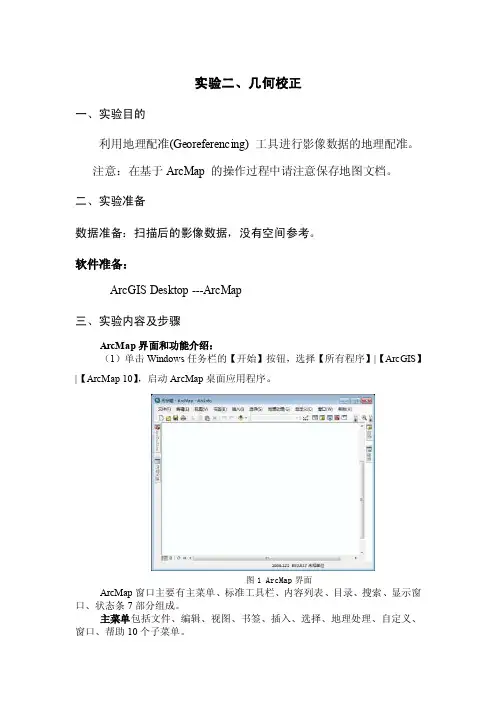
introduce to GIS3_Georeferencing_I[1]
- 格式:pdf
- 大小:2.11 MB
- 文档页数:26
Geography / Planning 281
Introduction to GIS - 9
Topographic Maps (cont.)
•
Example: Topographic map representing relief with contour lines Characterised by largescale detail Traditional discipline of topography takes into account all natural and man-made features of terrain
•
Used for phenomena which vary smoothly across the map, such as temperature, air pressure rainfall pressure, rainfall, elevation elevation, or population density
Geography / Planning 281
Types of Maps
•
T Two broad b d classes l of f maps:
•
Topographic map – a reference map tool, which shows many natural and cultural geographic features (i.e. forests, roads, political boundaries)
•
A representation, normally to scale and on a flat medium, of a selection of material or abstract features on, or in relation to, the surface of the earth M Maps show h more th than the th earth’s th’ surface f
•
•
Expressed as:
Verbal statement Describes in words e.g. 1 cm equals 1 km Proportion between map distance and d ground d di distance t e.g. 1:100,000 Line or bar represents some set distance 0 5 10 km e.g.
Geography / Planning 281
Introduction to GIS - 13
3. Georeferencing I
»
What is a map? Types of maps Map scale Mapping the Earth Map datums Map projections GIS compared to maps
– – – – – Cultural Features: Roads, buildings, boundaries, railways, power lines Water: Lakes, rivers, streams, swamps, rapids Elevation: Contour lines indicate mountains, valleys, slopes, depressions Vegetation: Wooded and cleared areas, vineyards and orchards T Toponymy: Pl Place names, water t feature f t names, highway hi h names
Geography / Planning 281
Introduction to GIS - 3
Cartographic Abstraction
•
Process of map making
•
5 stages:
• • • • •
Selection of the few features in the real world to include Simplification involving elimination elimination, aggregation aggregation, smoothing (i (i.e. e of jagged lines like coastlines) Exaggeration and displacement of features to be included that are too small to show at the scale of the map (i.e. highways) Classification or other attribute data manipulation (to reduce complexity and organize mapped information for communication) Symbolization to represent the different classes of features chosen
•
•
Geography / Planning 281
Introduction to GIS - 11
Thematic Maps (cont.)
(ii)
•
Area class map
Shows zones of constant attributes, such as vegetation, soil type, or forest species The boundaries are different for each map as they are determined by the variation of the attribute being mapped
• The term “map” is used loosely to refer to any visual display of information,
•
particularly if it is abstract, generalized or schematic
Geography / Planning 281
•
•
e.g. breaks of soil type may occur independently of breaks of vegetation
•
Natural boundaries
Geography / Planning 281
Introduction to GIS - 12
Geog/Plan 281 (Fall 2010) Lecture 3 Dr. Su-Yin Tan
•
•
Geography / Planning 281
Geog/Plan 281 (Fall 2010) Lecture 3 Dr. Su-Yin Tan
5
(b) Thematic Maps
(i)
•
Choropleth map
Uses reporting p g zones such as counties or census tracts to show data such as average household income, education level, or crime rates Zone boundaries are established independently of the data, and may be used to report many different sets of data Human-imposed boundaries
Geography / Planning 281
Geog/Plan 281 (Fall 2010) Lecture 3 Dr. Su-Yin Tan
7
Map Scale
•
Definition
The ratio between distances on the map and corresponding distances in the real world (i.e. ground distance) • What is large scale and small scale?
6
Thematic Maps (cont.)
(iii)
•
Isoline map
Shows an imaginary g y surface by y means of lines joining points of equal value
•
e.g. contours on a topographic map
• Maps are the main source of data for GIS • A map is an analogue database • GIS has roots in the analysis of information on maps • GIS overcomes many of the
Geography / Planning 281
Introduction to GIS - 8
Geog/Plan 281 (Fall 2010) Lecture 3 Dr. Su-Yin Tan
4
(a) Topographic Maps
•
Topographic map of the Kitchener Area
The map p communication p process:
Geography / Planning 281
Introduction to GIS - 4
Geog/Plan 281 (Fall 2010) Lecture 3 Dr. Su-Yin Tan