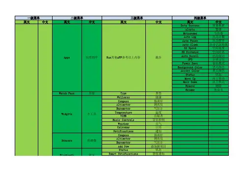
佳明飞耐时3(fenix3)手表菜单中英文对照
- 格式:xls
- 大小:41.50 KB
- 文档页数:7
mass stor. 存储器 garmin 佳明
page1 page2 page3可分别设置在记录航迹时
、导航时和室内模式时行程信息页面的数量以
及每个页面想要显示的行程信息内容
on demand 实时数据 always on累积数据
display 显示
letters/deg.字母角度 Letters/mils字母密位 degrees角度数 mils 军用幅角单位
north ref.北向选择
ture真北 magnetic地磁北极 grid网格北极 user自行修订磁偏角
mode模式-使用时机
auto移动时自动整合GPS/on用罗盘指示方向/off用GPS指示方向
calibrate校准
auto cal.GPS自动计算
at start启动GPS时校准 continuous实时校准 off关闭GPS辅助校 准使用气压计测量高度
altimeter高度计
ANT sensors ANT设 备
bluetooth 蓝牙 tones蜂鸣
heart rate心率设备 bike spd/cad 自行车速度/踏频设备/功 率计/骑行台 tempe外置温度传感器 foot pad计步器 connection连接 notifications提醒 pair new配对
hddd'mm'ss.s' WGS84 WGS84
birth year 出生年份weight 体重height 身高 gender 性别lifetime athlete 运动员生涯
on/off on/off
go To line导航线是否随位置改变
tracks航迹
map colors地图颜色 method记录模式
interval记录间隔 auto start自动启动
track动保存 auto pause自动暂停 output航迹格式 time page时钟页面
baro. Plot气压计模式
fixed 高度固定观看天气变化amb.press当前气压变化 variable运 动中高度变化
elev. Plot更改绘图类型
elev/dist单位距离海拔落差 elev/time单位时间海拔落差
3D data 3D数据
3D speed 3D速度
3D distance 3D距离
add alarm增加闹钟
timer倒数计时器
stopwatch秒表,可停
止或计圈
alt. zone多时区设置
proximity警示点 distance距离 time时间
间隔设置、终点距离和偏离航线三种警 示 间隔设置、离日落和终到时刻三种警示
elevation海拔高度
最大、最小、总爬升高度和总下降距离 四种警示
auto自动 5米8米 show hide bearing目标方位随之改变/course航线方向不 随位置改变 normal 正常 marine 航海 auto自动记录 distence按距离间隔 time按时间 间隔 normal正常less often频率少 least often频率最
GPX、GPX/FIT、FIT time layout 4种时钟布局 sec. style 秒针模式 addl. data 附加显示(如电池) ind. incons 是否显示指示图标,如卫星 12-hour 12小时模式 24-hour 24小时模式 military 军用模式
format时间格式
clock时间功能 alerts警示功能
units单位
pos. format坐标格式 profiles功能模式 fitness健身
time zone时区 dist./speed 距离/速度 elevation 海拔 depth 深度 temp 温度 pressure 压力 vert speed 垂直速度 format坐标格式 datum坐标系统 spheroid椭球模型设置 sailing航海Running 跑步Hiking徒步 Aviation飞行cycling骑行fishing钓鱼 geocaching寻宝Mountaineering 登山 auto lap自动计圈
一级菜单
二级菜单
start GPS启动GPS
setup设置
system系统
三级菜单 gps mode GPS模式
waas广域差分定位,增强GPS精度, 中国无
hot keys热键
data pages行程信息 sensors传感器
language语言 usb mode usb模式 tracking记录航迹 navigating导航 indoor室内 mode模式 compass指南针
calibrate校准
on off newsearch新搜索
on off newsearch新搜索
on off newsearch新搜索 on off newsearch新搜索
tone蜂鸣/vibration震动/tone&vib蜂鸣+震动 /none无 on/off
north up上为北方 track up上为航线
nav. Arrival抵达
抵达航点、航迹和航线终点警示
speed速度
pace踏频
heart rate心率
cadence心率区间改 超出预设心率区间时警示
battery电量
电量低于百分比时警示
waypoints航点 tracks航迹
routes航线 GPS tools GPS工 具
profiles功能模式 share data无线数 据分享
找到航点后有导航、 浏览地图、信息、编 辑、删除、位置平均 (累积平均提供精准 度)、投影航点(输 入目标点的方位与距 离)和移到当前位置 当前航迹
浏览航迹
tracback航迹返航,返回到航迹的起点 save保存当前位置 save part分段保存 details信息 view map浏览地图 clear删除当前航迹 go导航 view map浏览地图 details信息 display显示 rename重命名 reverse创建反向数据 delete删除
四级菜单/选项
normal正常每秒钟更新 ultratrac省电模式每分
钟更新 indoor室内关闭 demo mode模拟GPS
开启
on off
off start/stop开始结束记录航迹 lap计圈 mob紧
急地点 flashlight手电筒 timer时间页面
setnogpliwshatc英h语
message信息
display显示 reset重置
map地图
keys按键 backlight 背光 contract 对比度 trip data行程数据重置 clear plots传感器资料重置 waypoints删除全部航点 track删除当前航迹 all settings还原出厂设置 orientation地图朝向 auto zoom自动缩放 points航点显示比例尺 track log航迹显示
satellite卫星 sight ‘N go目测导航
project wat. coordinates输入坐标 定位 POIs预测到达时间 geocaches寻宝游戏 sun & moon日出日落 月升月落时间 hunt & fish 钓鱼狩猎 建议时间 area calc.面积测量
wpt. Avg. mob紧急地点 active route激活路线 jsuamilipngm航a海steRru跳n伞nin专g家 HAHO HALO STATIC 跑步Hiking徒步 Aviation飞行cycling骑 行fishing钓鱼 geocaching寻宝 Mountaineering 登山 sbkais-sencoawmbpo软ard件滑共板享滑 unit To unit设备互传
user用户数据
HR zones心率值
fit activity运动类型
foot pod speed计步器速度
bike speed骑行速度
virtual partner虚拟伙伴
geocaches寻宝游戏
menu菜单
设置菜单各个选项的顺序
about关于
关于 软件版本、电子序列号、GPS软 件版本。
alarm clock闹钟