美国领土扩张----Territorial-Expansion-of-America
- 格式:ppt
- 大小:478.00 KB
- 文档页数:14
美国的领土扩张去纽约,游览位于纽约湾的利勃坦岛(即自由岛)上的自由女神像是必不可少的,因为她太有名了,她是美国人民争取自由的象征。
去自由岛需乘渡轮,而渡轮回程经过艾利斯岛移民博物馆,我们算是意外地顺道浏览了一下这个博物馆。
在博物馆里,我照下了一幅专门记载美国领土扩张的地图,回来后查了查资料,现简介于此,与大家分享。
随着地理大发现(新航路的开辟),加勒比海地区和美洲相继被发现。
欧洲殖民者开始大量进入美洲地区,十七世纪初,英国开始向北美移民。
最初的北美移民主要是一些失去土地的农民,生活艰苦的工人以及受宗教迫害的清教徒。
1620年,英国人在北美建立了第一个殖民地弗吉尼亚,经过不断拓殖,到18世纪30年代,英国人已在北美大西洋沿岸建立了13个殖民地。
此外荷兰人、西班牙人、葡萄牙人、法国人也先后来到这里,各自圈地建立自己的殖民地。
1775年在波斯顿爆发了史称的《美国独立战争》,1776年7月4日,北美13个殖民地宣布脱离英国独立。
此时,美国领土只有大西洋沿岸13个州的面积,约80万平方公里。
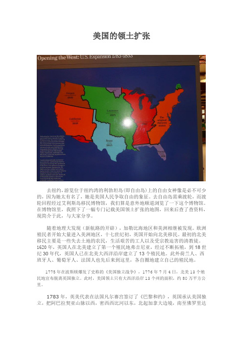
1783年,英美代表在法国凡尔赛宫签订了《巴黎和约》,英国承认美国独立,把阿巴拉契亚山脉以西,密西西比河以东,北起加拿大边境,南至佛罗里达边界的全部土地划归美国,并入13个州,面积共达230万平方公里,占现在美国本土面积的约30%。
1803年,美国利用拿破仑在英法战争中遇到的困难处境,以联英抗法相要挟,仅用1500万美元便从法国手中“购得”路易斯安那这片从密西西比河直达落基山的广大平原,面积约215万平方公里,相当于当时美国全部版图的一倍,从而使美国领土猛翻一番,而这片买来的土地,每英亩只花了约三美分!1818年,美国取得了英属殖民地俄勒冈。
1819年,美西签订条约,美国仅花了500万美元就从西班牙手中获得15万多平方公里的佛罗里达。
1842年8月9日,美国和英国签订了韦伯斯特-阿什伯顿条约(Webster-Ashburton Treaty),解决双方争议的明尼苏达、缅因北部边界,使其东北的边界上移。


英文概括美国领土扩张历史附中文How did the USA expand its territory in its formation?In July 4, 1776, 13 colonies in North America declared their independence from Britain. In 1783, through Treaty of Paris (1783), Britain recognized the sovereignty of the United States,and offered to cede all the land between the east of the Mississippi River and the Atlantic coast. In 1803, the Louisiana Purchase almost doubled the nation’s area. In 1819 because of internal and external troubles, Spain entered into Adams–Onís Treaty of 1819 with the United States, which led Spain cede Florida and other Gulf Coast territory. Then, the United States successively obtained the Texas and Oregon areas from Mexico and Britain by means of countermeasures and threats. In 1848, the victory of America in the Mexican-American War resulted in the Mexican Cession of California through the 1848 Treaty of Guadalupe Hidalgo. Then in 1853, James Gadsden, U.S. ambassador to Mexico at that time, bought nearly 100 thousand square kilometers of land along the US-Mexico border for $10 million. In 1867, the United States purchased Alaska from the Russian Empire for 7.2 million dollars, which covers an area of 1.5 million square kilometers. In the late nineteenth Century, the United States also acquired some islands in the Pacific through war, such as Hawaii. Although this is twenty-first Century, the ambitions of American expansion never cease.1776年7月4日,北美洲的13个殖民地宣布脱离英国独立。

美国领土扩张史路易斯安那82.8万平方英里的土地。
由此,美国奠定了其作为大国的基础。
对此,拿破仑如此说法:“进入这片领土可使美国的地位永远屹立不摇,而我则为英国创造了一个迟早会挫其锋芒的海上对手”。
四、借势推进借此,美国还将版图扩展到佛罗里达和德克萨斯。
实际上,早在1795年,美国就同西班牙签订了《平克尼条约》,即《对洛伦佐条约》,获得在下密西西比河上的自由航行权和在新奥尔良3年“存栈权”,为美国侵占美洲西班牙领地创造了条件。
《转让路易斯安那条约》签订后,美国利用条约未明确规定路易斯安娜的边界线,于1804年2月24日通过“摩尔比法案”,在密西西比河流域建立一个行政区,称“密西西比地区单独关税区”,将佛罗里达纳入行政范围。
美国并以此为据,向西班牙提出对西佛罗里达的领土要求。
美国这一要求为西班牙所拒绝。
但是,1810年,美国乘西班牙美洲殖民地发生革命之际,在东西佛罗里达策划美国农场主进行一系列叛乱活动,1811年初,美国派军队占领西佛罗里达。
1812年至1814年爆发美英战争。
战争期间,美国战胜西班牙,侵占亚拉巴马2/3的土地、东西佛罗里达及其毗邻地区,并将西佛罗里达并入美国密西西比地区。
此外,美国还摧毁印第安人的部落联盟,逐渐霸占印第安人在密执安湖一带的土地。
至1819年,美国利用西班牙美洲殖民地起义风起云涌的形势,通过向西班牙支付500万美元,实现了对东、西佛罗里达10多万平方公里土地的占领和兼并合法化,使领土面积达到460多万平方公里,相当于现领土面积一半以上。
五、向北向西扩展 1818年,美英举行西北边界谈判,就位于落基山脉与太平洋之间的俄勒冈,即北纬42度至54度40分之间(包括现今美国华盛顿州、俄勒冈州、爱达荷州、蒙大拿州和怀俄明州的一部分以及加拿大不列颠哥伦比亚一半)的争议地区归属问题,达成一项折衷协议:从伍兹湖到落基山顶端,以北纬49度线为界,位于落基山脉以西的俄勒冈在10年内由英美共管,对两国公民与臣民自由开放。


American Territorial Expansion and its DevelopmentAfter its independence, America began its territorial expansion in large scale. The territorial expansion and development not only made America become a large country in geography, but also had a great influence on American development which made America a great nation in the world.During "The Era of Good Feeling", America's economy prospered, the nation expanded westward. In 1818, a treaty with Britain gave America the Red River Basin, north of the Louisiana Territory and Spain ceded Florida to the United States in 1819. As we all know, the westward expansion is the most famous event in America history. Many historians divide the westward expansion of the United States into three great frontiers and is based on manifest destiny. The first frontier was the eastern seaboard, from the Atlantic Ocean to the Appalachian Mountains, where the European colonists established the thirteen American States. The westward Movement is a term usually used to describe the second and third frontiers. The second frontier was the west of the early United State, the region between the Appalachian Mountains and the Mississippi River. After the Louisiana Purchase (1803) and the war of 1812 and the subsequent removal of the Indians, large scale western expansion into this region occurred. Furthermore, from the late 1830's the federal government forcibly removed Eastern Indian tribes to the Great Plains area west of the Mississippi River. This policy allowed settlers to move into Indian lands without fear of reprisals. The third frontier was the Great West, stretching from the Mississippi River to the Pacific Ocean and can be subdivided into two sections: the territory between the Mississippi River and the Rocky Mountains and the region between the Rocky Mountains and the Pacific coast. Large numbers of people moved into the region after the government built large dams, which provided water for larger populations. When congress annexed Texas in 1854, Mexico severed diplomatic relations with the United States. In 1864, President James Polk sent General Zachary Taylor to occupy land near the Rio Grande River, Claimed by both America and Mexico. Fighting broke out between the two sides, and on May 13, 1846 Congress declared war on Mexico. After the United States defeated the Mexican army, the treaty of Guadalupe Hidalgo gave the United States a vast stretch of land from Texas west to the Pacific and north to Oregon. In return, the US paid the Mexican government $15000000. Then was the Oregon territory, Alaska, and Hawaii. Since America and Britain were unable to agree on a line of division, they agreed in 1818 to leave Oregon "free and open" to the citizens of both countries, Britain gave up its claim to land south of 49 degrees latitude establishing the western boundary between Canada and the United States. In 1853 America bought 777000 square kilometers of border lands from Mexico, paying $10000000. In 1867, Alaska was purchased from Russia for $7200000 which increased the land area of the US by 20%. Alaska became a state in 1959. Hawaii, an independent kingdom since 1810, was annexed by the United States as a territory in 1898 at the request of the Hawaiian legislature. In 1960 Hawaii was admitted as the 50th state - the only state that lies outside North America.The territorial expansion and its development have given great benefits to the America.The rapid development of America and its great status around the worldwide has fully proved it. Though America has a very short history, as an independent and well-developed nation, undoubtedly, it can be immortal in our human beings’ history.。
【美国历史系列】美国领土变迁和历史沿革美国疆域变迁图美国行政区划图1783年9月30日,《巴黎条约》签订,美国独立获得承认以来,美国领土向西扩张,前后扩张了7次,州数也由13州增加到50州。
【英属十三殖民地】1783年9月3日18世纪60年代至70年代,经过一系列抗争,殖民地联合武装反对英国和英王乔治三世的统治,最终于1775年爆发美国独立战争。
1776年7月19日,《独立宣言》的正式标题被定为《北美十三国联合一致的共同宣言》,英属十三个殖民地宣布独立。
1789年3月4日,美国宪法开始生效。
各州批准宪法的日期不同。
通常将英属北美十三个殖民地按地理位置从北至南排列。
新英格兰殖民地:1、新罕布什尔省(英王直辖殖民地)——新罕布什尔州,2、马萨诸塞湾省(英王直辖殖民地)——马萨诸塞州和缅因州,3、罗德岛及普罗维登斯种植地(自治殖民地)——罗德岛州,4、康涅狄格殖民地(自治殖民地)——康涅狄格州,中部殖民地:5、纽约省(英王直辖殖民地)——纽约州和佛蒙特州,6、新泽西省(英王直辖殖民地)——新泽西州,7、宾夕法尼亚省(私有殖民地proprietary colony)——宾夕法尼亚州,8、特拉华殖民地(私有殖民地proprietary colony)——特拉华州,南部殖民地:9、马里兰省(私有殖民地proprietary colony)——马里兰州,10、弗吉尼亚殖民地及自治领(英王直辖殖民地)——弗吉尼亚州、肯塔基州和西弗吉尼亚州(弗吉尼亚和马里兰合称切萨皮克殖民地),11、北卡罗来纳省(英王直辖殖民地)——北卡罗来纳州和田纳西州,12、南卡罗来纳省(英王直辖殖民地)——南卡罗来纳州,13、佐治亚省(英王直辖殖民地)——佐治亚州和亚拉巴马及密西西比两州的北部地区。
【西北领地】1789年8月7日西北领地(Northwest Territory),亦称为俄亥俄之西北的领地(Territory North West of the Ohio),是美国建国初期的一块联邦政府领地。