一些麦田圈在google earth的坐标
- 格式:doc
- 大小:25.00 KB
- 文档页数:2
Google谷歌地图上没有显示某个地址的经纬度,实际上,通过浏览器可以找到在谷歌地图上任意地点的经度和纬度。
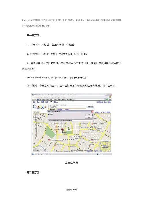
第一种方法:
1、打开Google地图,在上面寻找一个地址。
2、移动地图,让这个地址正好处于地图的正中心位置。
3、当您想寻找坐标位置已经处于地图的中心位置的时候,复制以下代码到你的电脑浏览器地址栏:
javascript:void(prompt('',gApplication.getMap().getCenter()));
你将得到一个弹出式的坐标,这个坐标就是你需要找的经度和纬度,如下图所示。
查看经纬度
第二种方法:
鼠标点击Google地图界面上右键“这儿是什么?”,就可以直接在地址栏看到当前位置的经纬度了。
(此文档部分内容来源于网络,如有侵权请告知删除,文档可自行编辑修改内容,
供参考,感谢您的配合和支持)。
世界著名地标的GoogleEarth地理坐标巴黎圣母院:48°51'11.39"N,2°20'56.95"Es:48°51'39.74"N,2°20'9.26"E巴黎埃菲尔铁塔:48°51'29.54"N,2°17'40.19"E自由女神像:40°41'21.48"N,74° 2'40.38"W胡夫金字塔:29°58'33.22"N, 31°7'49.29"E古罗马大竞技场:41°53'24.32"N,12°29'31.16"E英国的巨石阵:51°10'44.32"N,1°49'43.38"W印加遗迹:马丘比丘:13° 09'48.07"S,72°32'44.69"W纽约世贸大楼40°42'41.63"N 74°00'43.92"W●“约克镇”号坐标:32°47'25.40"N,79°54'30.11"W●“星座”号坐标:47°33'11.30"N,122°39'17.24"W●“独立”号坐标:47°33'7.53"N,122°39'30.13"W●“游骑兵”号坐标:47°33'10.63"N,122°39'9.53"W●“佛瑞斯特”号和“萨拉托加”号坐标:41°31'39.59"N,71°18'58.70"W●“美利坚”号坐标:39°53'6.36"N,75°10'45.55"W●“黄蜂”号坐标:37°46'21.80"N,122°18'10.80"W●“无畏”号 CV-11 坐标:40°45'53.88"N,74° 0'4.22"W上海东方明珠电视塔 31 14'29.59''N,121 29'41.97''E西昌卫星发射中心 28 12 29.02N, 101 56 46.74E 到 28 11 17.43N,102 07 27.81E欢度春节(成都) 30 39'39.89''N,104 03'48.20''E三峡30°50'45"N 111°01'27"E三门峡34°50'N 111°21'21"E造船厂38 56'29.92"N 121 38'37.72"E机场41°42'15.70" N, 86°08'23.20" E北塔山边防站 45.367370,90.573400巴黎罗浮宫: 48°51'39.61"N 2°20'10.82"E埃及狮身人面像29°58'31.82"N 31° 8'15.48"E埃及狮身人面像29°58'30.93"N 31° 8'15.65"E平壤柳京大厦39° 2'10.87"N125°43'48.50"E海参崴 42.8689845164N, 132.517761198E飞机坟场32°09'19.17N 110°49'46.69W平壤柳京大厦39° 2'10.87"N125°43'48.50"E波多黎各阿雷西博太空射电望远镜18°27'20.05"N 66°44'53.19"W 怀特曼空军基地38°43'40.89"N 93°33'21.58"W自由女神像40°41'21"N 74°02'40"W德国科隆大教堂50°56'29.57"N 6°57'30.58"E俄国的核潜艇 42.8689845164N, 132.517761198E八达岭长城 40 22`00.32"n,115 59`02.16"e八达岭 40 21`16.05"n,116 00`23.44"eHollywood 34 8'2.39"N, 118 19'17.91"W战斗机38° 54' 11.02" N 125° 14' 04.28" E旧金山总部37°25'19.23"N 122°05'03.20"W莫斯科红场55°45'12.93"N 37°37'13.94"E法国巴黎埃菲尔铁塔48°51'31.54"N 2°17'36.36"E意大利罗马圣彼德大教堂41°54'08.98"N 12°27'20.15"E英国伦敦纳尔逊广场51°30'30.35"N 0°07'40.22"E北京故宫39°55'00.86"N 116°23'26.93"E澳大利亚悉尼歌剧院33°51'26.07"S 151°12'56.24"E美国纽约世贸遗址40°42'40.32"N 74°00'46.12"W美国圣海伦火山46°11'13.07"N 122°11'04.48"W非洲南部好望角34°21'16.92"S 18°29'26.77"E巴拿马运河9°00'23.86"N 79°35'57.42"W戴维斯空军基地 32.165978,-110.854884印度被曝光的Sukhoi 30 MKI战斗机 18.5784602315, 73.9199699249 凯旋门48°52'26.79"N,2°17'42.66"ENOKIA Theatre 32.76685200,96.98219800秘鲁神秘巨型地表图案14°41'11.61"S,75°10'23.26"W撞机事件51°52'17.78"N,0°34'0.13"W大三角图案37°39'56.22"N116° 1'30.90"W核设施37°50'38.81"N116°43'53.01"W北韩核反应堆 40.09505600,128.34080800比尔盖茨豪宅 47.62778500,-122.24189100里约热内卢-耶稣山22°57'5.72"S,43°12'36.65"W雅典-卫城37°58'18.87"N,23°43'32.81"E宛如龟甲-小田原城35°15'7.56"N,139° 9'12.81"E丰臣秀吉-大阪城34°41'16.16"N,135°31'29.36"E赤道雪-乞力马扎罗3° 3'53.24"S,37°20'56.85"E黑鸟战机+航母+潜艇+战舰40°45'52.01"N 74° 0'1.23"W断桥25°55'46.42"N 80° 7'49.58"W古罗马大竞技场:41°53'24.32"N,12°29'31.16"E标凯旋门: 48°52'26.79"N,2°17'42.66"E凡尔赛宫: 48°48'17.76"N,2° 7'18.24"E巴黎圣母院: 48°51'11.39"N,2°20'56.95"E卢浮宫: 48°51'39.74"N,2°20'9.26"E埃菲尔铁塔: 48°51'29.54"N,2°17'40.19"E自由女神像: 40°41'21.48"N,74° 2'40.38"W胡夫金字塔: 29°58'43.41"N,31° 8'5.06"E狮身人面像: 29°58'31.81"N,31° 8'15.10"EMiyake-jima(日本的一个火山岛,还在冒烟)34.0833816528, 139.52865600627.9782502279, 86.9221941736 珠穆朗玛峰(Mount Everest)珠穆朗玛峰(Jo-mo glang-ma,在尼泊尔被称为),简称珠峰,又意译作圣母峰,位于中国和尼泊尔交界的喜马拉雅山脉之上,终年积雪。
Google earth 趣图地面上有很多图案在空中看非常有趣,下面就是总结了一些有意思的图案和相应的经纬度坐标,仅供大家欣赏。
1、橡树林中的“心”形经纬度坐标:51°36'26.20"N 2°23'11.90"WGoogle earth 截图:图案缘由:英国一名农夫花费17年时间,种下6000棵摆成“心形”的橡树纪念逝去的妻子。
报道称,现年70岁的农场主温斯顿•霍维斯家住英国南部格洛斯特郡。
17年前,她的爱妻因为心力衰竭撒手人寰。
悲痛之余,霍维斯突然想到可以在田地里用树木“造一颗心”纪念亡妻。
他先用小橡树在田地上“画”出一个心形。
接下来十多年,他又将心形以外的土地种满。
2、毛主席万岁经纬度坐标:42 39'18.85" N 94 10'00.80" EGoogle earth 截图:图案缘由:卫星图上出现的“毛主席万万岁”等5条标语信息,为原第八航校官兵在戈壁滩上创造的奇迹,这些环绕机场的“语录”地标,可以帮助飞行员保持空域位置,引导教、学员准确进出空域,地标所在区域的中心点,便是柳树泉机场。
其中一角还有一条废弃跑道。
因为柳树泉机场地处戈壁,附近没有明显的地物特征!飞机都是设备简单的初教机,导航设备简陋,所以就弄了语录地标。
3、为人民服务经纬度坐标:42 32'33.95" N 94 19'36.80" EGoogle earth 截图:4、只争朝夕经纬度坐标:42 39'33.30" N 94 16'00.59" E Google earth 截图:图案缘由:同25、向斗争中学习经纬度坐标:42 27'40.95" N 94 14'36.80" E Google earth 截图:6、排除万难去争取胜利经纬度坐标:42 27'12.08" N 94 08'49.36" E Google earth 截图:图案缘由:同27、祖国在我心中经纬度坐标:39 41'43.47" N 73 55'37.17" E Google earth 截图:图案缘由:同28、大三角图案经纬度坐标:37°39'56.22"N116° 1'30.90"WGoogle earth 截图:图案缘由:不详9、三峡大坝经纬度坐标:30°49'20.34"N 111°0'14.58"E Google earth 截图:图案缘由:中国长江上的水电站三峡大坝10、美国飞机坟场经纬度坐标:32°09'19.17N 110°49'46.69W Google earth 截图:图案缘由:美国亚利桑那州图森市戴维斯·蒙山空军基地。

Google Earth 名胜、要址经纬坐标清华东门39°59'42.59"N, 116°19'36.71"E5号楼40°00'18.41"N, 116°19'22.81"E为人民服务94.32319167E,42.54462222N向斗争中学习94.243125E,42.46101389N排除万难去争取胜利94.14704444E,42.45335556N只争朝夕94.26648611E,42.65985833N毛主席万岁94.17217222E,42.655625N香格里拉-松赞林寺(经文) 99.69783333E,27.86808444N咸阳塬上的汉朝的陵冢:34 21`39.25"n,108 38`22.04e非常偏远的边境,卫国戍边39 41'43.47"n,73 55'37.17"e金字塔:29 58'29.93"n,31 07'47.05"e上海东方明珠电视塔31 14'29.59''N,121 29'41.97''E纳斯卡地画蜻蜓:14°42'24.43"S, 75°9'11.27"W高清拉斯维加斯:36°10'30.00N,115°08'11.01W超清:12°20'40.48"S 40°35'11.82"E(附近有三个彩蛋)15°17'54.36N 19°25'47.21E看到人脸(非洲):13°35'42.03N 20°00'23.40E牛马:15°17'54.36N 19°25'47.21E八达岭长城:40 22`00.32"n,115 59`02.16"e好莱坞:34 8'2.39"N, 118 19'17.91"W珠峰27°58'49N 86°55'14E三峡30°50'45"N 111°01'27"E三门峡34°50'N 111°21'21"E造船厂38 56'29.92"N 121 38'37.72"E机场41°42'15.70" N, 86°08'23.20" E北塔山边防站45.367370,90.573400巴黎罗浮宫: 48°51'39.61"N 2°20'10.82"E埃及狮身人面像: 29°58'31.82"N 31°8'15.48"E 埃及狮身人面像;29°58'30.93"N 31°8'15.65"E平壤柳京大厦: 39°2'10.87"N125°43'48.50"E 海参崴42.8689845164N, 132.517761198E飞机坟场32°09'19.17N 110°49'46.69W平壤柳京大厦: 39°2'10.87"N125°43'48.50"E 波多黎各阿雷西博太空射电望远镜: 18°27'20.05"N 66°44'53.19"W怀特曼空军基地;38°43'40.89"N 93°33'21.58"W自由女神像:40。

谷歌地球---一些比较有名的地方经纬度坐标!29 58'29.93"n,31 07'47.05"e 金字他34 21'39.52"n,108 38'22.04"e 金字他中国27 54'22.85"n,87 04'03.42"e山峰31 14'29.59''N,121 29'41.97''E 上海东方明珠电视塔详细经纬度28 12 29.02N, 101 56 46.74E 到28 11 17.43N,102 07 27.81E---西昌卫星发射中心30 39'39.89''N,104 03'48.20''E 欢度春节珠峰27°58'49N 86°55'14E三峡30°50'45"N 111°01'27"E三门峡34°50'N 111°21'21"E造船厂38 56'29.92"N 121 38'37.72"E机场41°42'15.70" N, 86°08'23.20" E北塔山边防站45.367370,90.573400巴黎罗浮宫: 48°51'39.61"N 2°20'10.82"E埃及狮身人面像: 29°58'31.82"N 31° 8'15.48"E埃及狮身人面像;29°58'30.93"N 31° 8'15.65"E平壤柳京大厦: 39° 2'10.87"N125°43'48.50"E海参崴42.8689845164N, 132.517761198E飞机坟场32°09'19.17N 110°49'46.69W平壤柳京大厦: 39° 2'10.87"N125°43'48.50"E波多黎各阿雷西博太空射电望远镜: 18°27'20.05"N 66°44'53.19"W怀特曼空军基地;38°43'40.89"N 93°33'21.58"W自由女神像:40°41'21"N 74°02'40"W德国科隆大教堂: 50°56'29.57"N 6°57'30.58"E慕尼黑安联体育场(开幕式)48.219147789,11.6263784774柏林奥林匹克体育场(决赛)52.5133561136,13.2398110056汉诺威AWD竞技场52.3599290703,9.73288538378汉堡世界杯体育场53.5869222364,9.9012440719多特蒙德维斯特法伦体育场51.4927357971,7.45381528043盖尔森基奥夫沙尔克竞技场51.5537521117,7.06907863308凯泽斯劳滕沃尔特体育场49.4337693907,7.77715096552纽伦堡法兰克人体育场49.4259497861,11.1241851189斯图加特戈特利布戴姆勒体育场48.7931489667,9.23328332718莱比锡中央体育场(改建前)51.3464198348,12.3509946539法兰克福森林体育场(改建前)50.0696330234,8.64661484093俄国的核潜艇42.8689845164N, 132.517761198E八达岭长城:40 22`00.32"n,115 59`02.16"e40 21`16.05"n,116 00`23.44"e这里才是八达岭Hollywood 34 8'2.39"N, 118 19'17.91"W 38° 54' 11.02" N 125° 14' 04.28" E战斗机旧金山总部地理坐标:37°25'19.23"N 122°05'03.20"W 莫斯科红场地理坐标:55°45'12.93"N 37°37'13.94"E法国巴黎埃菲尔铁塔地理坐标:48°51'31.54"N 2°17'36.36"E意大利罗马圣彼德大教堂地理坐标:41°54'08.98"N 12°27'20.15"E英国伦敦纳尔逊广场地理坐标:51°30'30.35"N 0°07'40.22"E北京故宫地理坐标:39°55'00.86"N 116°23'26.93"E澳大利亚悉尼歌剧院地理坐标:33°51'26.07"S 151°12'56.24"E美国纽约世贸遗址地理坐标:40°42'40.32"N 74°00'46.12"W美国圣海伦火山地理坐标:46°11'13.07"N 122°11'04.48"W非洲南部好望角地理坐标:34°21'16.92"S 18°29'26.77"E巴拿马运河地理坐标9°00'23.86"N 79°35'57.42"W埃及金字塔地理坐标29°58'31.58"N 31°07'56.32"E35°44'00"N 139°21'00"E 小日本的飞机场37°46'18.88"N 122°18'11.42"W36°57'29.02"N 76°19'43.30"W50°48'07.14"N 1°06'43.73"W50°48'31.05"N 1°05'49.17"W43°06'36.79"N 5°53'54.18"E30°23'45.04"N 81°24'28.31"W32°42'38"N 117°11'23"W50.9334895375,6.87657386777戴维斯空军基地Davis Monthan AFB32.165978,-110.854884印度被曝光的Sukhoi 30 MKI战斗机18.5784602315, 73.9199699249凯旋门: 48°52\'26.79\"N,2°17\'42.66\"E凡尔赛宫: 48°48\'17.76\"N,2° 7\'18.24\"E巴黎圣母院: 48°51\'11.39\"N,2°20\'56.95\"E卢浮宫: 48°51\'39.74\"N,2°20\'9.26\"E埃菲尔铁塔: 48°51\'29.54\"N,2°17\'40.19\"E古罗马大竞技场: 41°53\'24.32\"N,12°29\'31.16\"E自由女神像: 40°41\'21.48\"N,74° 2\'40.38\"W胡夫金字塔: 29°58\'43.41\"N,31° 8\'5.06\"E狮身人面像: 29°58\'31.81\"N,31° 8\'15.10\"EMiyake-jima(日本的一个火山岛,还在冒烟)34.0833816528,139.52865600627.9782502279, 86.9221941736 珠穆朗玛峰(Mount Everest)珠穆朗玛峰(Jo-mo glang-ma,在尼泊尔被称为????? ??),简称珠峰,又意译作圣母峰,位于中国和尼泊尔交界的喜马拉雅山脉之上,终年积雪。

苦练精兵:43°43'48.00"N 87°40'6.00"E秘鲁纳斯卡平原巨画:14°41'45.39"S,75°10'35.48"W一只草组成的象:48°51'28.33N 10°12'18.66E泰山:36°14'23.89"N,117° 6'29.89"E手掌岛·迪拜·阿联酋:25° 6'36.49"N 55° 8'45.60"E (美国·科罗拉多州·谷物迷宫;40°17'52.88"N 104°45'37.05"W美国.犹他州.曲颈状国家公园: 37° 8'49.74"N 109°54'46.88"W 51°21'23.17"N 0°11'54.13"E38°24'5.51"N 90°37'12.63"W52°33'35.88"N 0°23'9.79"W44°40'51.62"N 10°19'2.16"E53°41'40.64"N 1°33'32.44"W53°32'28.25"N 1°32'7.94"W53°31'55.52"N 1°21'25.43"W53°32'14.78"N 1°30'19.99"W51°56'46.13"N 0°23'28.61"W39°14'49.05"N 85°54'35.37"W51° 0'37.09"N 0° 1'9.07"E51°28'49.86"N 0°53'57.45"W51°37'15.10"N 4°30'30.75"E52°14'44.34"N 0°39'32.80"W51°45'55.68"N 1° 9'44.49"W山峰:27 54'22.85"n,87 04'03.42"e西昌卫星发射中心; 28°14'47.81"N 102° 1'32.04"E巴黎罗浮宫:48°51'39.61"N 2°20'10.82"E埃及狮身人面像:29°58'31.82"N 31° 8'15.48"E平壤柳京大厦39° 2'10.87"N125°43'48.50"E波多黎各阿雷西博太空射电望远镜18°27'20.05"N 66°44'53.19"W 怀特曼空军基地38°43'40.89"N 93°33'21.58"W俄国的核潜艇42°52′8″,132°31′4″Hollywood :34 8'2.39"N,118 19'17.91"W战斗机38° 54' 11.02" N 125° 14' 04.28" E旧金山总部37°25'19.23"N 122°05'03.20"W莫斯科红场55°45'12.93"N 37°37'13.94"E法国巴黎埃菲尔铁塔48°51'31.54"N 2°17'36.36"E意大利罗马圣彼德大教堂41°54'08.98"N 12°27'20.15"E英国伦敦纳尔逊广场51°30'30.35"N 0°07'40.22"E北京故宫39° 54' 58.69",+116° 23' 48.94"美国纽约世贸遗址40°42'40.32"N 74°00'46.12"W美国圣海伦火山46°11'13.07"N 122°11'04.48"W非洲南部好望角34°21'16.92"S 18°29'26.77"E巴拿马运河9°00'23.86"N 79°35'57.42"W戴维斯空军基地32.165978,-110.854884印度被曝光的Sukhoi 30 MKI战斗机18°34′42″ 73°55′12″五角大楼:38°52'15.63"N,77°3'21.52"W秘鲁纳斯卡平原巨画附近的飞机14°42'12.53"S,75°8'5.27"W世界上最富丽堂皇的豪华酒店25°8′34″,55°11′14″ (位于阿拉伯联合酋长国的迪拜)中央电视台以及央视台标:39°54′24″,116°18′49″拉萨布达拉宫:29.657917,91.11716751号地区飞碟发源地;37°14′11″,-115°49′0″ (在美国西南部内华达州赌城拉斯维加斯(Las Vegas)的北部(并非正北,北偏西约30度)约130公里处,Groom Lake的南缘。
谷歌地图十大恐怖坐标第一部分、谷歌地图十大恐怖坐标分别为:中东地区公牛的眼睛,南太平洋的幻影岛,金字塔的重现,哈萨克斯坦的大五角星,澳大利亚的UFO,苏丹巨大的嘴唇,新墨西哥州沙漠上的钻石,伊拉克地区的血湖,中东地区的车轮,巨大的商标,这十大恐怖坐标之后有着十分神奇的秘密。
一、中东地区的公牛眼睛从谷歌地图上看,中东地区有一个圆形小区域,如同一只公牛的眼睛,因此这个点的坐标十分奇异。
二、南太平洋的幻影岛在南太平洋上有一个狭长的小岛,从谷歌地图上看,这个狭长的小岛轮廓上有一圈幻影,也引来了观测者的好奇。
三、金字塔的重现从谷歌地图上看,在埃及地区有一个非常偏僻的地方,似乎拥有一个新的金字塔,但是仔细一看,这个地方只是和金字塔十分相似而已。
四、哈萨克斯坦的大五角星在谷歌地图上可以非常清晰地看出,在哈萨克斯坦地区有一个巨大的圆形五角星,这个圆形五角星经过测量,直径达到了370米。
五、澳大利亚的UFO从谷歌地球上观看澳大利亚地区,似乎澳大利亚地区中部有一个大型的UFO停靠站,很多人怀疑这是澳大利亚和外星人联系的地区。
六、苏丹巨大的嘴唇苏丹地区大部分以山地和丘陵为主,但是在山地和丘陵之间,突然出现了一个红色的嘴唇,也引来了人们的好奇心。
七、新墨西哥州沙漠上的钻石在新墨西哥洲地区有一巨大沙漠上,仿佛放置了巨大的钻石,钻石在沙漠地区显得十分的显眼,也有人怀疑这是外星人所建造的。
八、伊拉克地区血湖地球上所有的核的颜色应该都是蓝色,但是从谷歌地图上来看,伊拉克地区有一个湖的颜色为血红色,这确实十分恐怖。
九、中东地区的车轮中东地区有着十分广袤的沙漠,但是沙漠上却出现了许许多多车轮的形状,这些出门的形状有大有小,十分奇异。
十、巨大的商标谷歌地图在美国拍摄了一个最大的商标广告,就是可口可乐公司的广告,可口可乐公司在地上用五颜六色的瓶子摆出了一个肯德基的模样。
第二部分.谷歌地图十大神秘之地,谷歌地图的出现,为大家的生活带来极大方便,同时也引起具有好奇心和探险精神的「好事之徒」,在谷四处搜寻,找到了不少鲜为人知的神秘地带。

google earth 坐标大全(谷歌地球坐标大全)41 degrees 13'07.74, "N 112 degrees 01'37.90", W, a painting on a farm13 degrees 35'42.03N, 20 degrees 00'23.40E, a baffling place, surrounded by fuzzy, here is super clear53 degrees 31'55.63 "N 1 degrees 21'25.19" W crop circles48 degrees 51'28N, 10 degrees 12'18E, a very large insect entity,I do not know how it happened29 degrees 58'33N, 31 degrees 07'50E, Pyramid41 degree 53'24N 12 degrees 29'31E Rome round duel field27 58'41.20N, 86 55'18.31E Mount Qomolangma29 degrees 58'33.82, "N 31 degrees 8'13.62", E Sphinx, and Khufu, Pyramid37 "14'18.05" N115 "48'52.17" W 5137 degrees 38'44.05 "N115 degrees 48'6.40" W painted place36 degrees 57'13.54, "N, 76 degrees 19'37.38" W, Norfolk Naval base, a lot of aircraft carriers ah ~!25 degrees 6'45.80, "N, 55 degrees 7'55.42" E, UAE - Dubai artificial The Palm Islands25 degrees 0'23.07, "N, 54 degrees 59'12.19" E, UAE - Dubai artificial The Palm IslandsKhufu, Pyramid: 29.9758941775,31.1303588639Badaling (Yanqing County, Badaling town) 40 degrees 21'15.41, 116 degrees 00'24.21"Davies Air Force Base 32.165978, -110.85488440.09505600/128.34080800 North Korea nuclear reactor47.62778500/-122.24189100 Bill Gates MansionIndia was exposed to the Sukhoi 30 MKI fighter 18.5784602315, 73.9199699249Triumphal Arch: 48 degrees 52'26.79, N, 2 degrees 17'42.66, EPalace of Versailles: 48 degrees 48'17.76, N, 2 degrees 7'18.24, ENotre Dame de Paris: 48 degrees 51'11.39, N, 2 degrees 20'56.95, ELe Louvre Museum: 48 degrees 51'39.74, N, 2 degrees 20'9.26, EEiffel Tower: 48 degrees 51'29.54, N, 2 degrees 17'40.19, EAncient Rome Coliseum: 41 degrees 53'24.32, N, 12 degrees29'31.16, EStatue of Liberty: 40 degrees 41'21.48, N, 74 degrees 2'40.38, WKhufu Pyramid: 29 degrees 58'43.41, N, 31 degrees 8'5.06, E Miyake-jima (a volcanic island in Japan, still smoking), 34.0833816528, 139.528656006, 27.9782502279, 86.9221941736 Mount Qomolangma (Mount Everest)Mount Qomolangma (Jo-mo glang-ma, in Nepal) is referred to as Mount Everest, and is also translated as Mount Everest. It is located on the Himalaya mountains at the border of China and Nepal, and is covered with snow all year round. It is the highest peak in the worldCrop circle 53 31'54.33N, 1 21'22.63WNazca lines Peru mysterious huge surface patterns 14 degrees 41'11.61, S, 75 degrees 10'23.26, WCollision event 51 degrees 52'17.78, N, 0 degrees 34'0.13, W37 degrees 39'56.22, "N116 degrees 1'30.90", W large triangle pattern, 37 degrees 50'38.81, N116 degrees 43'53.01, W nuclear facilities40.09505600/128.34080800 North Korea nuclear reactor47.62778500/-122.24189100 Bill Gates luxury house search windAthens - Acropolis 37 degrees 58'18.87, N, 23 degrees 43'32.81, ELike the tortoise - Tian Yuan city 35 "15'7.56" N, 139 "9'12.81" EToyotomi Hideyoshi - Osaka City 34 degrees 41'16.16 "N",135 degrees 31'29.36 "E"The snow of Kilimanjaro - 3 "3'53.24" S, 37 "20'56.85" E of the Stonehenge in the United Kingdom 51 "10'44.32" N, 1 "49'43.38" WInca ruins: Machu Picchu 13 "09'48.07" S, 72 "32'44.69" W34 degrees 08'02.97, N, 118 degrees 19'17.94, W, Hollywood, Hills25 degrees 55'46.42 "N 80 degrees 7'49.58" W broken bridge45 degrees 30'26.40, "N 73 degrees 32'52.94", W CircusGreat Barrier Reef Great, Barrier, Reef, 18 degrees 21'04.58, S, 146 degrees 47'58.81, E 34.932808, -117.876949 found42 27'12.08 "n 94 08'49.36" E and surmount every difficulty to win42 39'33.30 "n 94 16'00.56" e seize the day42 27'40.95, "n, 94 14'36.80" e learn from the struggle42 32'33.95, "n, 94 19'36.80" e serve the people42 39'18.85 "n, 94 10'00.80" E, long live Chairman Mao!99.69783333E 27.86808444N, Shangri-La - Songzanlinsi39 41'43.75,73 55'37.39, the motherland is in my heart43 45'16.93 "N 87 40'03.75" E battle how to play, how do soldiers practice?43 48'09.37 "N 87 40'17.65" E focus on actual temper troops27 51'29.88, N, 99 43'13.73, E, Shangri-LaEdwards Air Force Base34.664955, Vandenberg Air Force Base in California -120.578728 Gary5.187950 Kuru -52.712746, French Guiana spaceport is the world's major space launch base in one of the world's best space launch site launch site: Kuru41.528320, the two aircraft carriers at -71.316000 port in Boston, 33.362882,40.596521, an airport in western Iraq, are no longer available. A number of sandbags were piled up at a distance from the runway.34.950321,69.266160, a Military airports in eastern Afghanistan, is very secluded. 28.230400102.032089 Xichang satellite launch site, 65 km northwest of Xichang. Xichang satellite launch center is located in Xichang.41.035309100.368347 Jiuquan Satellite Launch Center (local) 45.997009,63.286743 Baikonur spaceport is located in the southern Kazakhstan southwest of the city of Baikonur 280 kilometers, 75 kilometers wide north-south, east-west width of 90 kilometers, the area is large, the Google maps may be only partial. 38 "56'31.81" N 121 38'41.10 "E the ship docked in Dalian aircraft carrier, the Varyag is the legendary. Comrades also said that when in Dalian, who can see the high-rise buildings in Dalian Port can see, it is not a secret, buy scrap ironBadaling: 40 degrees 21'15.41, N, 116 degrees 00'24.21, ETriumphal Arch: 48 degrees 52'26.79, N, 2 degrees 17'42.66, EPalace of Versailles: 48 degrees 48'17.76, N, 2 degrees 7'18.24, ENotre Dame de Paris: 48 degrees 51'11.39, N, 2 degrees 20'56.95, ELe Louvre Museum: 48 degrees 51'39.74, N, 2 degrees 20'9.26, EParis Eiffel Tower: 48 degrees 51'29.54, N, 2 degrees 17'40.19, EStatue of Liberty: 40 degrees 41'21.48, N, 74 degrees 2'40.38, WThe World Trade Center twin tower site: 40 degrees 42'42.19 "N 74" 00'44.45 "WThe Empire State Building: 40 degrees 44'54.74, "N 73 degrees 59'10.88", WRed Square and the Kremlin: 55 degrees 45'08.86, "N 37 degrees 37'23.05" EThree Gorges 30 degrees 50'45 "N 111 degrees 01'27" ELuding bridge 29 "54'52.39" N 102 "13'48.61" EBill Gates's Mansion: 47 degrees 37'37.71, N, 122 degrees 14'33.26, WBig slogan "how to fight, how to practice soldiers?"!" : 43 degrees 45'19.10, N, 87 degrees 40'4.90, EForeigners also make big slogans "Go Wings!":42 degrees10'29.19, N, 83 degrees 11'41.36, WBroken bridge: 25 degrees 55'46.42, N, 80 degrees 7'49.58, WCircus: 45 degrees 30'26.40, "N 73 degrees 32'52.94" WGreat Barrier Reef: Great, Barrier, Reef, 18 degrees 21'04.58,S, 146 degrees 47'58.81, ECollision event: 51 degrees 52'17.78, N, 0 degrees 34'0.13, WChad's ultra high resolution oasis: 15 17'54.35, n 19,25'46.38''e50 meter long scary monster: 48 51'28.33N, 10 degrees 12'18.66EA herd of hippos: 28 degrees 19'18.43, s 32, 24'30.16EBig triangle: 37 degrees 39'56.22, N116 degrees 1'30.90, WShenzhen Minsk aircraft carrier (China Shenzhen) 22 degrees 33'14.51, N, 114 degrees 14'12.74, EDalian Varyag (China Dalian) 38 "56'27.91" N, 121 "38'36.75" ERussian Kurtz tesuo USS wal 69 "2'25.07" N, 33 "4'12.13" EIndia aircraft carrier, 18 degrees 55'27.30, N, 72 degrees 50'37.40, EIndia aircraft carrier two, 18 degrees 55'52.83, N, 72 degrees 50'34.26, EBrazil two aircraft carriers (front and rear arrangement) 22 degrees 53'38.43, S, 43 degrees 10'13.20, WBritish aircraft carrier 50 degrees 48'32.21, N, 1 degrees5'47.82, WFrench carrier 43 degrees 6'40.67, N, 5 degrees 53'46.18, ESpain aircraft carrier 36 degrees 37'12.62, N, 6 degrees19'52.20, WThe Kitty Hawk (Yokosuka base Japan) 35 "17'30.53" N, 139 "39'47.73" EAmerican aircraft carrier 39 degrees 53'7.68, N, 75 degrees 10'47.66, WUnited States George Washington aircraft carrier 36 degrees 57'33.63, N, 76 degrees 19'47.06, WUSS Lincoln, 47 degrees 58'54.38, N, 122 degrees 13'41.98, WUnited States near San Francisco aircraft carrier 37 degrees 46'22.67, N, 122 degrees 18'9.75, WRhodes Island, the United States 2 aircraft carrier, 41 degrees 31'43.32, N, 71 degrees 18'56.27, WUnited States Truman aircraft carrier 36 degrees 48'54.45, N, 76 degrees 17'47.32, WUSS W, 32 degrees 42'48.80, N, 117 degrees 11'21.02USS Lexington (Museum) 27 "48'54.13" N, 97 "23'19.65" WUSS Intrepid (retired after Vietnam) 40 degrees 45'55.79, N, 74 degrees 0'3.64, WAmerican town of York aircraft carrier 32 degrees 47'24.70, N, 79 degrees 54'26.75, WU.S. enterprise aircraft carrier 36 degrees 57'27.89, N, 76 degrees 19'46.98, WUSS Washington, USS Constellation 47, 33'11.30 N,122 degrees 39'17.24 "W"USS Washington state independence base aircraft carrier 47 degrees 33'7.53, N, 122 degrees 39'30.13, WU. S. state naval base Ranger horse carrier 47 degrees 33'10.63, N, 122 degrees 39'9.53, WUnited States John Kennedy aircraft carrier 30 degrees 23'49.85, N, 81 degrees 24'27.62, WThe United States aircraft carrier Midway Islands 37 "47'40.07" N, 122 "16'59.52" WHsinchu AB (Hsinchu air base), second (499th) tactical fighter wing, 24 degrees 49'05, N 120, 56' 21, EHualien AB (Hualian air base), fifth (401st) tactical fighter wing, 24 degrees 01'23, N 121, 37' 04, EKangshan AB (Okayama air base) Air Force Academy, 22 degrees 46'54, N 120, 15' 43, EKaohsiung Hsiao-kang Intl (Kaohsiung International Airport) civilian 22 degrees 34'31, "N 120 degrees 21' 02" ELan Yu / Orchid Island (Orchid Island) Airport, 22 degrees 01'59, N 121, 32' 60, ELungtang (dragon pond) small civil airport, 24 degrees 51'18, N 121, 14' 15, EMakung Airport (Magong Airport) military / civilian 23 degrees 34'03, "N 119 degrees 37' 44" EMatsu Peigan Airport (Matsu North Pole Airport) Airport 26 degrees 13'31, N 120 degrees 00' 00, EMatsu South (Nangan Airport) Airport 26 degrees 09'02, "N 119 degrees 57' 13" EPa Kuei / Bakuai (eight immortals) is unknown, 24 degrees 55'59, "N 121, 17' 60", EPenghu / Chimei (Penghu / seven Lantau) small civil airport, 23 degrees 31'05, N 119, 35' 04, EPingtung North (screen Northeast Air Base) 439th air force wing, 22 degrees 41'43, N 120, 28' 40, EPingtung South (screen southeast air base), 439th air force,22 degrees 40'20, N 120, 27' 42, EPratas Island (Tungsha) 20 "42'15" N 116 "43' 14" ESingapore Changi International Airport:1.36604863171104.003205457Seoul Incheon International Airport:37.4458383413126.453957247Heathrow Airport: 51.4654952963, -0.45468726657Haneda International Airport, Tokyo:35.5518209734139.78996876Tokyo Narita International Airport:35.7768962952140.394931041Kansai International Airport: 34.4381461683135.240790576New York John Fitzgerald Kennedy International Airport: 40.16896207603, -73.7878607292La Guardia Airport, New York: 40.7709196329, -73.8725781735 Frankfort International Airport: 50.0541882898,8.56882921999 Paris Charles de Gaulle Airport: 48.9986924434,2.57061168343Taipei Taoyuan CKS International Airport:25.0792104197121.239554291Hong Kong International Airport: 22.308558075113.932217673Chicago O'Hare International Airport: 41.9819547845,-87.8999733783Baltimore Washington International Airport: 39.1792298757, -76.6744909797Newark International Airport: 40.69291688399, -74.1845529215San Francisco International Airport: 37.6141019893,-122.395812287Las Vegas McCarran International Airport: 36.0882981415,-115.141345243Los Angeles International Airport: 33.9388100309,-118.402768344Hess ground International Airport, Atlanta: 33.6277350167, -84.4261286659Amsterdam Airport Schiphol: 52.290576817,4.76246825749Mount Qomolangma (Mount Everest):27.9782502279, 86.9221941736 note: Mount Qomolangma (Jo-mo glang-ma), referred to as Mount Everest, and free translation as Everest, located at the junction of Himalaya and Nepal China mountain, snow. It is the highest peak in the world.World War II bombers over the UK: 5220, 10.87N, 011, 43.34W note: it is said that the Flight of Britain Memorial (Battle) in the battle of Britain happened to have been photographed by a satellite bomber.The world's largest uncompleted residential flats: 39 degrees 02'11.11, "N, 125 degrees 43'48.39", E note: Pyongyang, "Liu Jing Hotel", cold war products. Founded in 1982, the initial budget cost $750 million, which is 2% of the total GDP of North korea. "Liu Jing Hotel" building for the triangular pyramid building, slope angle of 75 degrees, 330 meters high, covers an area of 360000 square meters, plans to have 3000 rooms, 7 rotating restaurants. If completed, it will be the world's tallest Hotel, the high building, or the world outside of New York and Chicago is higher than that of the first 100 storey building. After 5 years of construction, the electricity and capital shortages were halted.The United States and Utah, the neck shaped National Park: 37 "8'49.74" N 109 54'46.88 "W note: This is a retort shaped National Park of the original features, the park of the 1000 foot deep rift is accumulated in San JuanUnited States Colorado grain maze: 40 degrees 17'52.88, N 104 degrees 45'37.05, WPeru mysterious huge surface patterns: 14 degrees 41'11.61, S, 75 degrees 10'23.26, WCrop circles: 53 31'54.33N, 1 21'22.63WNOKIA Theatre:32.76685200/96.98219800Stonehenge in Britain: 51 degrees 10'44.32, N, 1 degrees49'43.38, WPeru Nazca giant painting 14 "41'45.39" S, 75 "10'35.48" WThe guy on the beach was photographed: 12 degrees 9'2.68, S, 40 degrees 33'23.24, EMiyake-jima (a volcanic island in Japan is still smoking),:34.0833816528, 139.528656006Shang Yi / Kinmen (righteousness / Kinmen) military / civilian 24 degrees 25'40, N 118 degrees 21' 31, ESungshan Taipei (Taipei Songshan Airport) military / civilian 25 degrees 04'10, "N 121 degrees 33' 09" ETa Shan Ting (Dashan Pavilion) Airport, 24 25'04, N 118, 14' 27, ETaichung (Taichung Air Force Base) military 24 degrees 11'04, N 120 degrees 39' 14, ETainan (Tainan air base), first (443rd) tactical fighter wing, 22 degrees 57'01, N 120, 12' 20, ETaitung (Taitung air base) seventh (737th) tactical combat 24 degrees 11'04, N 120, 39' 14, ETaoyuan (Taoyuan Air Force Base) Taoyuan command, 25 degrees 03'20, N 121, 14' 33, ETsoying (left) protection 22 "42'16" N 120 "16' 48" EWang An (hope) small civil airport, 23 degrees 22'04, "N 119 degrees 30' 07" EChang Hua (Changhua) is unknown 24 degrees 04'59''N, 120 degrees 31'59''EChia Tung (Jia Tong) is unknown, 22 degrees 25'00''N, 120 degrees 32'60''EDonggung (Donggang) is unknown, 22 degrees 28'00''N, 120 degrees 25'59''EDongshi (Dong Shi) is unknown, 23 degrees 16'00''N, 119 degrees 40'00''EHuwei (Taipei) is 23 degrees 42'37''N and 120 degrees 25'41''EIlan (Yilan) is unknown, 24 degrees 45'00''N, 121 degrees 46'00''ETaiwan military coordinateHsinchu AB (Hsinchu air base), second (499th) tactical fighter wing, 1200024 degrees 49'05, N 120, 56' 21, EHualien AB (Hualian air base), fifth (401st) tactical fighterwing, 909824 degrees 01'23, N 121, 37' 04, EKangshan AB (Okayama air base) Air Force Academy, 750022 degrees 46'54, N 120, 15' 43, EKaohsiung Hsiao-kang Intl (Kaohsiung International Airport) civilian 1033522 degrees 34'31, "N 120 degrees 21' 02" ELan Yu / Orchid Island (Orchid Island) Airport, 402622 degrees 01'59, N 121, 32' 60, ELungtang (dragon pond) small civil airport, 325224 degrees 51'18, N 121, 14' 15, EMakung Airport (Magong Airport) military / civilian 984023 degrees 34'03, "N 119 degrees 37' 44" EMatsu Peigan Airport (Matsu North Pole Airport) Airport 26 degrees 13'31, N 120 degrees 00' 00, EMatsu South (Nangan Airport) Airport 26 degrees 09'02, "N 119 degrees 57' 13" EPa Kuei / Bakuai (eight immortals) is unknown, 24 degrees 55'59, "N 121, 17' 60", EPenghu / Chimei (Penghu / seven Lantau) small civil airport, 672623 degrees 31'05, N 119, 35' 04, EPingtung North (screen Northeast Air Base) 439th air force wing, 800022 degrees 41'43, N 120, 28' 40, EPingtung South (screen southeast air base), 439th air force, 781722 degrees 40'20, N 120, 27' 42, EPratas Island (Tungsha) 492120 "42'15" N 116 "43' 14" EShang Yi / Kinmen (righteousness / Kinmen) military / civilian 984524 degrees 25'40, N 118 degrees 21' 31, ESungshan Taipei (Taipei Songshan Airport) military / civilian 8,546 25 04 10°“N 121°33’09”E塔珊婷(大山亭)机场24°25 ' 04“N 118°14’27”E台中(台中空军基地)军用5315 24°11 ' 04“N 120°39’14”E台南(台南空军基地)第1(第443)10007 22 57 01战术战斗机联队°“N 120°12’20”E台东(台东空军基地)第7(第737)5315 24 11 04战术战斗°“N 120°39’14”E桃源(桃园空军基地)桃园司令部10044 25°03 ' 20“N121°14’33”E左营(左营)军用3500 22°42 ' 16“N 120°16’48”EWang An(望安)小型民用机场3076 23°22 ' 04“N 119°30’07”E可能用于基地导航的设施(无跑道)常华(彰化)不详24°最大可计04分59秒与120°最大可计31分59秒''eChia Tung(佳桐)不详22°25分与120°32 ''e 60Donggung(东港)不详22°28分与120°最大可计25分59秒''e董氏(东石)不详23°16分与40分119°''eHuwei(虎尾)不详23°42 '37与120°103'41 ''e 25Ilan(宜兰)不详24°45分与46分121°''e名胜古迹之类胡夫金字塔:29°58 '33.22“N,31°7 '49.29 E古罗马大竞技场:41°53 '24.32“N,12°29 '31.16 E英国的巨石阵:51°10 '44.32“N,1°49 '43.38“W印加遗迹:马丘比丘:13°09 '48.07”,72°32 '44.69“W香格里拉-松赞林寺(经文):27°52 '5.10“N,99°41 '52.20 E德国科隆大教堂:50°56 '29.57“N 6°57 '30.58 E雅典-卫城:37°58 '18.87“N,23°43 '32.81 E宛如龟甲-小田原城:35°15 '7.56“N,139°9 '12.81 E丰臣秀吉-大阪城:34°41 '16.16“N,135°31 '29.36 E赤道雪-乞力马扎罗:3°3 '53.24”,37°20 '56.85 E八达岭:40°21 '15.41“N,116°00 '24.21 E凯旋门:48°52 '26.79“N,2°17 '42.66 E凡尔赛宫:48°48 '17.76“N,2°7 '18.24 E巴黎圣母院:48°51 '11.39“N,2°20 '56.95 E卢浮宫:48°51 '39.74“N,2°20 '9.26 E巴黎埃菲尔铁塔:48°51 '29.54“N,2°17 '40.19 E自由女神像:40°41 '21.48“N,74°2 '40.38“W世贸中心双子星大厦遗址:40°42 '42.19“N 74°00 '44.45“W 帝国大厦:40°44 '54.74“N 73°59 '10.88“W红场和克里姆林:55°45 '08.86“N 37°37 '23.05 E30°45三峡50“N 111°01他“E泸定铁索桥29°54 '52.39“N 102°13 '48.61 E比尔盖茨的豪宅:47°37 '37.71“N,122°14 '33.26“W大标语”仗怎么打,兵怎么练!": 43 degrees 45'19.10," N, 87 degrees 40'4.90 ", EForeigners also make big slogans "Go Wings!":42 degrees10'29.19, N, 83 degrees 11'41.36, WBroken bridge: 25 degrees 55'46.42, N, 80 degrees 7'49.58, W Circus: 45 degrees 30'26.40, "N 73 degrees 32'52.94" WGreat Barrier Reef: Great, Barrier, Reef, 18 degrees 21'04.58, S, 146 degrees 47'58.81, ECollision event: 51 degrees 52'17.78, N, 0 degrees 34'0.13, WChad's ultra high resolution oasis: 15 17'54.35, n 19,25'46.38''e50 meters long KB Monster: 48 degrees 51'28.33N, 10 degrees 12'18.66EA herd of hippos: 28 degrees 19'18.43, s 32, 24'30.16EBig triangle: 37 degrees 39'56.22, N116 degrees 1'30.90, W White House: 38 degrees 53'23.90, "N 77 degrees 00'32.60" W The Pentagon: 38 degrees 52'15.39, "N 77 degrees 03'22.02" WU. S. nuclear facilities: 37 degrees 50'38.81, "N116 degrees 43'53.01" WDavies Air Force Base: 32 degrees 9'57.52, N, 110 degrees 51'17.58, WNorth Korea nuclear reactor: 40 degrees 5'42.20, N, 128 degrees 20'26.91, EWhitman Air Force Base: 38 degrees 43'40.89, "N 93 degrees 33'21.58" WRussian nuclear submarine: 42.8689845164N, 132.517761198ERussian SU-27 base: 50 degrees 36'8.91, N 137 degrees 4'47.63, EBEITASHAN border station: 45 "22'2.53" N, 90 "34'24.24" EChengdu Airplane Company new enemy: 30 degrees 42'17.16, N 103 degrees 57'21.71, EXichang satellite launch base: 28 degrees 14'22.38, "N 102 degrees 01'28.95" E1:1 model of Air Force Base: 40 degrees 23'04.16, "N 99 degrees 53'50.63", EEmpty three divisions, 27:31 degrees 23'37.25, N, 118 24'58.22, ETiger head Bay, Sanya: 18 10'41.10, n 109 34'51.81, e36 Air Division: 34 large "n 109 07'10" e 22'19Lantau Peak land and air base and army light weapons shooting range: 30 degrees 43'50.99, N 104 degrees 05'26.16EWorld Cup pitch coordinatesAllianz stadium, Munich (opening ceremony)48.219147789,11.6263784774Berlin Olympic Stadium (final) 52.5133561136,13.2398110056Hannover AWD arena 52.3599290703,9.73288538378Hamburg World Cup Stadium 53.5869222364,9.9012440719Dortmund West Fallon stadium 51.4927357971,7.45381528043Garson Keogh J Schalk arena 51.5537521117,7.06907863308Kaiser Slaoui ten Walter stadium, 49.4337693907,7.7771509655249.4259497861,11.1241851189, Frank stadium, NurembergGottlieb Daimler stadium, Stuttgart,48.7931489667,9.23328332718Leipzig Central Stadium (before reconstruction)51.3464198348,12.3509946539Frankfurt forest Stadium (before reconstruction)50.0696330234,8.64661484093Speacial~~~Our campus 39 degrees 05'32.73n, 117 degrees 08'00.75e。
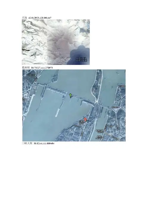
天池42.012953,128.061447葛洲坝30.73527,111.278973三峡大坝30.8214,111.009464三门峡大坝34.828107,111.352057小浪底水库、大坝34.922367,112.370444因加水电站位于刚果民主共和国境内刚果(Congo)河的下游,在金沙萨西南约250km的因加地区内。
工程目的是发电,拟分阶段进行开发。
混凝土支墩坝,最大坝高52.5m。
已建成的2座水电站-因加1号和因加2号水电站,是第一阶段的工程。
因加1号水电站于1968 年5月开工,于1972年建成并投入运行,装机35万kW;因加2号水电站于1973年初动工,于1979〜1981年建成并投入运行,装机140万kW。
因加1号和因加2号水电站(Inga I & II Hydropowe rStation )是世界上最大的水电站大因加水电站(Grand Inga Hydropowe rStation)工程的一部分,Grand Inga总装机容量高达3900万KW,发电量是目前世界第一的三峡水电站的两倍。
因加水电站(图中显示为因加1号和因加2号水电站)复活节岛-27.115046,-109.39501指出的位置就是石像,下面是地面照相所拍到的上图位置处的石像尼亚加拉瀑布-17.923439,25.851865维多利亚瀑布 Victoria Falls伊瓜苏瀑布-25.689414,-54.440732安赫尔瀑布Angel Falls 5.969083,-62.536411 位于委内瑞拉,是世界落差第一大的瀑布(979米)图盖拉瀑布Tugela Falls, Gaints Castle Game Reserve, KwaZulu-Natal, South Africa-28.752159,28.894279非洲落差最大的瀑布,气势磅礴,宏伟壮观。
位于非洲南部,南非纳塔尔省,图盖拉河上。
◆毛主席万万岁:42 39 18.85 n,94 10 00.80 e◆香格里拉:27 51 29.88 N,99 43 13.73 E◆严格要求严格训练:45°6 56.73 N, 82°31 32.44 E◆苦练精兵:43°43 45.72 N, 87°40 12.59 E◆卫国戌边以卡为家:45°22 3.47 N, 90°34 23.67 E◆白宫:38°53 23.90 N 77°00 32.60 W◆五角大楼:38°52 15.39 N 77°03 22.02 W◆看见一群河马:28°19 18.43 s 32°24 30.16 E◆爬山:34°54 35.02 N 111°46 21.58 W◆天然人头像:50.010083,-110.113006◆仙人:47.110579,9.227568◆麦田怪圈:37.401437,-116.86773◆象群:10.903497,19.93229◆福特车标:42.302284,-83.231215◆翻船事故:30.541634,47.825445◆停车场里的战斗机:48.825183,2.1985795◆排除万难去争取胜利:42 27'12.08"n,94 08'49.36"e◆只争朝夕:42 39'33.30"n,94 16'00.56"e◆向斗争中学习:42 27'40.95"n,94 14'36.80"e◆为人民服务:42 32'33.95"n,94 19'36.80"e◆香格里拉-松赞林寺:99.69783333E,27.86808444N◆一个莫名其妙的地方,周围都模模糊糊,就这里超级清楚:13°35'42.03N 20°00'23.40E◆47.62778500/-122.24189100比尔盖茨豪宅◆印度被曝光的Sukhoi 30 MKI战斗机18.5784602315,73.9199699249◆诡异符号19 12'13.45"S 70 0'30.41"W◆鱼31 59'20.53"S 152 34'18.47"E◆人猫19 56'56.76"S 69 38'2.07"W◆骑马的人50 39'26.33"N 2 24'14.92"W◆马54 13'29.68"N 1 12'44.46"W◆兔子44 14'39.77"N 7°46'10.71"E◆几何图形37 37'38.69"N 116 50'48.38"W◆11.97"N 21 18'7.81"E◆15 17'54.35"n 19 25'46.38''e◆宝马公司的总部大楼48°10 36.38 N 11°33 34.73 E◆99"N117°9'27.87"W◆37°04'54.37"N 76°21'06.92"W◆32°09'19.17N 110°49'46.69W12°34 10.43 S 32° 7 38.41 E13°42 7.16 S 31° 8 29.39 E15°17 40.26 N,20°28 48.17 E14°33 12.72 N 20°49 28.40 E18°43 40.63 S 35°55 56.92 E18°43 6.82 S 35°58 41.70 E21°50 36.11 S 35°27 0.47 E29°46 15.63 S 21° 0 31.07 E15°29 41.22 S 27°26 36.90 E世界最大的马桶28.4351513618,-81.4730418508一架奇怪的飞机-23.199765668,-45.8917173913巨大的龙字39.7519023523,98.2137761268S型建筑24°38 47.35 N 46°42 3.86 E沙漠中的轮船46.7692125119,61.6610114938飞机形状的游泳池39.9344318294,-74.8085926713路边的乌龟33.4306853111,-111.979150747奇怪的圈圈群7°56 17.96 S 14°22 31.29 W可口可乐广告18°31 44.16 S 70°15 0.10 W一张笑脸51°53 14.57 N 176°38 15.67 W太极八卦图38°57 4.53 N 121°33 47.90 E51°30 7.84 N 0° 5 29.02 E脚印:31°12 12.88 N 7°56 3.41 E嘴唇12°22 22.63 N 23°19 18.60 E国际象棋棋盘52° 4 25.13 N 4°17 32.62 E 40°43 12.80 N 74°0 48.66 W 北京某公园内的彩色中国地图39°39 46.06 N 116° 3 51.29 E棕榈25° 6 58.27 N 55° 8 3.48 E巫婆9°27 9.31 N 118°36 55.60 E狐狸45°7 25.63 N 123°6 50.27 W符号39°45 56.44 N 86°28 24.57 W38°24'5.51"N 90°37'12.63"W52°33'35.88"N 0°23'9.79"W53°32'28.25"N 1°32'7.94"W53°31'55.52"N 1°21'25.43"W51°45'55.68"N 1° 9'44.49"W南极UFO62°1'20.69N 42°41'51.29W废弃机场33.362882,40.596521Miyake-jima(日本的一个火山岛,还在冒烟)34.0833816528,◆香格里拉-松赞林寺(经文):27°52'5.10"N, 99°41'52.20"E◆世贸中心双子星大厦遗址:40°42'42.19"N 74°00'44.45"W ◆红场和克里姆林:55°45'08.86"N 37°37'23.05"E。
从谷歌地球看美国01-美国圆形农场
从谷歌地球看美国01-美国圆形农场
在GOOGLE EARTH (谷歌地球)的卫星图上,在美国的堪萨斯州、德克萨斯州等,可以看到许多地方有圆形的图案,如下图:
这些神秘的图案是什么?继续放大:
这其实就是美国的农场,一个圆形图案就是一块农田。
国内恐怕没有这种布局的农田,大多是长方形或长形状的。
这些圆形农田大大小小有很多规格的,比如上图中4个大的中间就有一个小的。
那这些图案有多大呢?用软件带的标尺量了一下,上图中最大的那个直径为1600米!面积就有:
S=3.14*800*800=200万平方米=3017亩
把农田做成圆形,实在浪费!浪费的面积应该是圆的外接四边形的面积减去圆形的面积:
S四-S圆=1600*1600-2000000=56万平方米=840亩
看来得提高一点利用率,于是美国人在这4个圆形农田的中间再开辟出一个小的圆形农田,该小圆面积是多大呢,计算稍复杂些,为了说明,弄了一个示意图:
可见小圆的半径为大圆直径的0.207倍,对于上述4个3000亩大农田中间的小农田,其面积为:
S小=3.14*(1600*0.207)^2=344437平方米=517亩
圆形农田相比方形农田,约有21%的地是浪费的。
那么美国人把农田做成圆形的目的是什么呢?
请看下面的图:
主要是为了灌溉!美国农田采用机械化施工,灌溉用的是大型旋转喷灌系统,如上图,这种方式有效率高、控制准确、水资源利用率高等优点。
除了灌溉系统,美国还大量使用农业机械。
以下是农庄里的飞机场和飞机。
美国耕地多,技术先进,生产效率高,难怪成为“世界粮仓”,小麦等农产品大量出口。
美国德克萨斯州农田里的圆圈(图片来源:googleearth)地球上的怪圈之谜文/马志飞说起麦田怪圈,大家应该都很熟悉。
自从20世纪70年代,人们开始注意到英国威尔士郡的麦田怪圈以来,世界各地已经出现了数千个大小及造型各异,图案复杂多样的麦田怪圈。
虽然很多学者试图从土壤、天气、水分、生物等多个角度进行解释,甚至还有人认为这是外星人的杰作或者是人类自己制造的恶作剧,但谜底迄今仍未完全解开。
除了麦田怪圈之外,地球上还存在很多有趣的怪圈,虽然它们看似不同寻常,成因也不尽相同,但都是大自然的杰作,在它们的背后都隐藏着一定的科学规律。
接下来就让我们一起揭开它们的秘密吧。
油菜田怪圈虽然麦田怪圈层出不穷,但在我国却极少发现,不过也曾有类似的怪圈出现在油菜田里。
2007年7月,新疆伊犁哈萨克自治州的昭苏县正在举办油菜花节,当摄影师乘坐热气球进行航拍时,意外地在油菜田里发现了一排直径约17米、间距约2~3米的大圆圈。
与国外的麦田怪圈不同的是,油菜田怪圈表现为圈内的油菜长得要比圈外的高出一大截。
事情传开之后,引发了人们的种种猜测:有人认为是农民施肥造成的,有人认为油菜田怪圈的土壤下方可能存在着古代遗址或者墓葬,还有人认为这纯粹就是故意闹着玩的。
后经研究发现,这都源于当地喷灌设施:由于喷灌水龙头间距安排过大,导致那些能被灌溉到的油菜生长旺盛,于是就形成了所谓的“油菜田怪圈”。
如果你观察卫星地图,就会注意到很多沙漠地区都存在这样的大圆圈。
比如,美国德克萨斯州和堪萨斯州就有许多因农作物自动灌溉而造成的大圆圈,成片分布,鳞次栉比,置身其中不觉得有任何异样,只有从高空俯瞰时,才会发现这些奇特的图案。
海底怪圈2012年的一天,日本有位摄影师在奄美大岛附近海域潜水,当他到达大约24米深的海底时,惊讶地发现一个奇怪的圆圈。
虽然它的直径只有1.8米左右,但形状十分独特,从圆心向外延伸出多条凹槽,呈间隔均匀的辐射状,看起来像齿轮的样子,更像是神秘的“麦田怪圈”。