层序地层学标准化
- 格式:ppt
- 大小:25.07 MB
- 文档页数:27


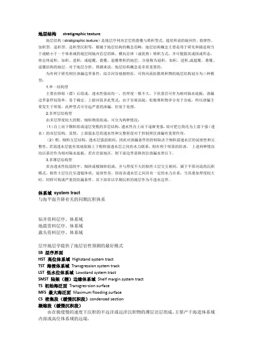
地层结构stratigraphic texture地层结构(stratigraphic texture)是地层序列内岩层的叠覆与堆积型式。
通常所说的旋回性、韵律性、加积型、退积型、进积型沉积等,都属于地层结构的概念范畴。
地层结构概念主要是用于研究和描述相当于或略小于一个体系域的地层间隔内岩层的纵、横向总体(或优势)堆积方式,并可根据其成因或形态,将总体退积、加积、进积,或超覆、叠覆、退覆堆积的地层,分别称为退积、加积、进积,或超覆、叠覆、退覆结构的地层。
对于地层分析、预测来说,地层结构概念是非常重要的。
为有利于研究坝区渗漏边界条件,结合河谷地貌特征,可将河流松散堆积物的地层结构划分为三种模型:1.单一结构型主要由卵砾(漂)石组成,透水性强而均一,但厚度一般不大。
下伏基岩可作为相对隔水底板,渗漏边界条件较简单,易于确定。
上游河段多此型式,由于谷坡高陡,松散堆积物多分布于谷底,所以渗漏主要发生于坝基。
此种型式可引起严重的渗漏,但易于处理。
2.多厚层结构型由多层厚度较大的粗、细粒物质组成,可分为两种情况:(1)自上而下颗粒组成逐层变粗的多层结构。
透水性自上而下逐渐变强,故可把它简化为上弱下强(透水)的双层结构。
显然,上部弱水层的透水性和完整程度对于控制坝区渗漏有重要作用。
(2)粗、细粒互层结构。
透水层强弱相间,因此对渗漏条件的控制取决于细粒弱透水层的延续性和完整性。
若弱透水层能有效地阻隔上下粗粒强透水层之间的水力联系,则有利于坝基的防渗。
上述两种情况均以基岩作为相对隔水底板。
若在岩溶地区,则下部边界需移到岩溶漏水带以下。
3.多薄层结构型常由透水性较弱的中、细砂或极细砂组成,并与厚度不大的粘性土层交互相间,属于平原河流的沉积模式。
粘性土层往往呈透镜体状,延续性差,因而各透水层之间具有一定的水力在系,当其叠加厚度较大时,同样可构成严重的防漏条件。
其下部常以早期沉积的地层作为不透水边界。
体系域system tract与海平面升降有关的同期沉积体系钻井资料层序、体系域地震资料层序、体系域露头资料层序、体系域层序地层学提供了地层岩性预测的最好模式SB 层序界面HST 高位体系域Highstand system tractTST 海侵体系域Transgression system trackLST 低水位体系域Lowstand system tractSMST 陆架(棚)边缘体系域Shelf margin system tractTS 初始海泛面Transgres-sion surfaceMFS 最大海泛面Maximum flooding surfaceCS 密集段(缓慢沉积段)condensed section凝缩段(缓慢沉积段)由在极缓慢的速度下沉积的半远洋或远洋沉积物的薄层岩层组成,主要产于海进体系域内部或高位体系域的远端。

层序地层学层序地层学是一门关于地球历史和地质结构的学科,也被称为地层学。
它研究地球表面各个层次的形成、演变、叠置、形态、性质性质和含矿条件等问题。
层序地层学是地质学中的一支重要学科,通过对地质历史进行层序分析,揭示出地球历史的演化过程和构造变化规律,对于理解地球演化史、指导矿产资源勘探开发、支持地质工程和环境保护等具有重要的意义。
下面是层序地层学的详细介绍。
一、层序地层学的概述层序地层学的研究对象是地球表层及其下部岩石的垂直柱状截面(地层柱)、水平展布面(地层露头)、空间分布(地层相)和时空演化过程。
它研究的目的是根据岩性、结构、古生物化石、古地理和特征地质事件等方面的特征,建立地层序列和地层层位,随着研究范围的不同,可以分为区域层序分析、盆地地层学、海相地层学、非海相地层学、构造地层学等。
层序地层学的研究方法主要包括岩石与古生物学、构造地层学、地震地层学、地球化学等方面的技术手段,通过对各种地质现象进行分析和比较,以正确的地图解读和理解,建立真实的地质模型。
二、层序地层学的研究目的和意义1. 研究地球历史和地质构造演化层序地层学的一个主要目的是了解地球历史和地质构造演化。
地球历史是地层学的主要内容之一,通过层次系统对地球历史进行分段和分类,对过去地球环境的演化和特征进行研究,可以推断出古环境、古地理、古气候和地球演化史的重要信息。
2. 指导矿产资源的勘探和开发层序地层学还可以指导矿产资源的勘探和开发。
通过对地层中各种矿产赋存环境、古地理环境和矿床类型的研究,可以确定矿床的分布规律和含矿性质的特征,从而提高矿床的勘探效果和开采利用效率。
3. 支持地质工程和环境保护层序地层学还可以支持地质工程和环境保护。
地层信息可以为工程地质勘察、工程建设和水文地质调查等提供有力的支持,帮助工程师设计科学合理的工程方案,为环境保护、资源可持续性利用和人类生存提供保障。
三、层序地层学的基本概念1. 地层地层是以一定标志为界限所划分出来的,具有一定厚度和广泛垂直分布的自然地质单元。

第9卷第2期黑龙江科学V〇l. 9 2018 年 1月HEILONGJIANGSCIENCE January 2018层序地层学简析万建华(黑龙江省煤田地质物测队,哈尔滨150036)摘要:层序地层学是我国众多科学家探寻的一门科学,其多样化的层序模式表明了科学家的劳动成果,复杂的底层记录暗示着其响应机制研究的不断深入。
在寻求强针对性层序底层模式的时代,其研究也影响了相关概念体系的一致和协调发展,因而寻求相关概念体系一致的层序地层学标准化成为重要课题,也是层序地层学研究的重要命题。
在层序地层学研究过程中,对海退的两种类型的区分和识别成为其发展的重要基础,这个过程与层序地层模式不同,因而成为其走向标准化的关键一步。
对层序地层学基本概念及发展历程进行介绍,阐述了层序地层学的标准化发展和相关应用。
关键词!层序地层学;简析;发展历程;应用中图分类号:P539.2 文献标志码:A文章编号:1674 -8646(2018)02 -0160 -02Analysis of sequence stratij»raphyW A N Jian-hua(Heilongjiang Coalfield Geological Survey T e a m,Harbin 150036, China)Abstract;Sequence stratigraphy i s a science that many scient ists in China explored.I t s diverse sequence patterns indicate the f r u i t s of scientistsr labor.The complicated underlying records imply i t s deepening research on response mechanism.In t he era of seeking the bottom-level model of strong-targeted sequence,the research also affected the unanimity and coordinated development of t l i e related conceptual systems.Therefore,i t i s an important topic t o seek t o standardize the sequence-leased sequence w i t l i the same conceptual system,which i s also an stratigraphy.In t he study of sequence stratigraphy,the two types of discrimination and identification of returnees become the important basis for their development.This process i s different from the sequence stratigraphic model and thus becomes a crucial step towards standardization.The basic concepts and development of sequence stratigraphy are introduced,and the standardization of sequence stratigraphy and i t s related applications are ex K e y w o r d s;Sequence stratigraphy;Analysis;Development hi st〇r;Application自20世纪70年代,相关地层学专著的发表标志 着层序地层学概念的提出,随着时代的不断发展,该学 科也逐步完善,走向系统化发展。
科学管理2016年第12期层序地层学标准化研究现状徐慧子西安石油大学地球科学与工程学院陕西西安710065摘要:经过几十年的探索,基本可以认为在被提出的条件下层序地层学中的每种方法均具有其合理性,而且是该环境下的最优方法,因而我们认为层序地层学将来的重点研究方向即为层序地层学标准化。
关键词:层序地层学标准化层序地层格架由于层序地层学能综合许多地层学及非地层学科的认识,故可称之为是一种应用于综合分析地层的有效方法。
1层序地层学的发展通常认为层序地层学是基于20世纪70年代的地震地层学而出现的。
但事实上,地震地层学是晚于大多数与层序地层学有关联的研究的。
早在18世纪,H u tto n就认识到侵蚀作用、沉积搬运和沉积作用随时间的周期性重复,并且创建了现在被称为“地质旋回”的基础。
Sloss等(1949)提出“层序”的意思是指界线为地表之上不整合的地层单元。
地层学中“层序”概念发展的同时,在随后的二十年间其他沉积学家们也再次提出“层序”是一种能够被人们预测并且拥有某种内在关联的垂向的沉积序列(P e ttijo h n,1975 ),同时它也能够指出沉积相的天然变迁。
现代层序的优势在于其层序界面具有一致性,全盆地范围分布,因此盆地边缘的层序数量等于盆地中心发现的层序数量。
由于相对应的整合面与基准面变化的参考曲线不一致,这种由不整合或其相对应的整合面为边界的新层序保留使用,但被认为不规范。
2层序地层学二十一■世纪初,O.Catuneanu等一■些国外知名的学者相继刊发了几篇关于层序地层学的发展及其标准化研究的必要性的论文,在文章中,几位学者及专家指出层序地层学的标准化将会作为重点内容在层序地层学将来几十年的发展中占据重要地位(朱如凯,2011)。
在这之后,我国的一些专家与学者由是也纷纷对层序地层学的标准化研究展开了探索与学习。
在这以前的层序地层学的研究中,能够被较为准确的区别其地层层序的通常都是野外踏勘取得的露头的资料或者一些单井的钻井资料;而如果要求的是对整个盆地研究其层序地层格架,那么对于地震剖面的质量以及地震测量相关人员的工作水平和职业素质就有着较髙的要求,也会直接影响层序划分的最终成果。
地层学——层序地层概念简介译者:王立群层序地层学是试尝关联相对海平面转变到沉积层的一门地质学方面的相对较新的分支。
该方式的基础是依照等时界面的识别进行地层作图(例如:地下不整合面、最大洪泛面),因此其大体点是放在年代地层框架上。
层序地层学是校正只强调岩性特点相似性而没有时刻意义的岩性地层学方式的最好选择。
名称中的“层序”涉及旋回沉积,而术语中的“地层学”涉及如下地质进程:一、沉积物形成的地质进程。
二、透过地球表面的时空,这些沉积物如何转变的进程。
目录:1、重要的界面1—1、层序界面1—2、准层序界面2、准层序和准层序组的类型3、地质时期的海平面4、经济意义5、参考文献1、重要的界面1—1、层序界面层序边界被以为是最重要的界面。
层序边界被概念为不整合面或与其相关的整合面。
多期河流砂岩体常常充填与层序边界相关联的海平面下降形成的深切河谷。
层序边界上的深切河谷在侧向上可与河间地域,形成于深切河谷边缘的古土壤相对照。
河谷充填在成因上与先期形成的下覆沉积系统无关。
依照多期砂岩沉积的其它类型有四种区别深切河谷充填的标准:一、比河谷内单河道侵蚀面散布更普遍的高侵面,在区域上可普遍对照。
二、在与下覆地层单元相对照时,相组合反映出盆地在岩相上向前移动。
3、河谷侵蚀面侵蚀掉前期形成的体系域而且在海岸产生时刻距离。
4、增加的河道充填和向上变细的剖面或反映增加可容空间的河流系统特点的转变。
和深切河谷相关的砂岩体是良好的储集层。
目前在这些岩体的对照和散布研究上还存在问题。
层序地层学原理和重要界面的识别有助于解决这些问题。
1—2、准层序界面次要的界面是准层序界面,只是也有人建议描述准层序边界的洪泛面与层序边界相较在侧向上散布更为普遍。
这是因为海岸平原与内陆架相较其倾斜度低的缘故。
准层序边界能够用界面上的物理和化学属性的不同相区别,它们是:地层水的含盐度、碳氢化合物的性质、孔隙度、紧缩速度和矿物学特点。
准层序边界不阻止油气的聚集,可是它能够抑制储层垂向上的联系。
鄂尔多斯盆地奥陶系马家沟组标准化层序地层学研究杨伟利;王起琮;刘佳玮;石堃;魏巍【摘要】应用标准化层序地层理论开展鄂尔多斯盆地奥陶系马家沟组层序地层研究.主要采用了露头观察和岩心描述、岩石薄片鉴定、地球化学分析及测井岩性解释方法,确定地层岩石类型、岩相组合特征、层序地层界面特征及其位置,结合绝对地质年龄及天文周期时限作为层序划分主要依据.文中将马家沟组划分为平均时限为3.65 Ma的3个海平面变化层序,根据岩相组合及地层界面将各层序划分为低位、海侵、高位及强制海退体系域,层序界面位于强制海退体系域顶界,形成于最低海平面开始上升时期,以石盐岩到硬石膏岩或硬石膏岩到准同生泥晶白云岩的岩性转换面为特征.研究结果表明,随着海平面升降运动,碳酸盐岩台地上的岩性组合及变化具有明显的规律性,突显了应用标准化层序地层理论建立的层序划分方案的合理性和实用性.%The standardized sequence stratigraphy theory is applied to investigate Ordovician Majiagou formation.According to kinds of data,such as outcrop,core and logs,the lithologic characteristics and litho facies assemblage characteristics combine with absolute geological ages and astronomical period,rejiggering the division plan about standardization of sequence stratigraphy in Ordovician Majiagou formation.The Majiagou formation can be divided into three sea-level change sequence,and according to the method of system tract four-division,the inside of each sequence is classified as Lowstand System Tract (LST),Transgressive System Tract (TST),Highstand System Tract (HST) and Regressive System Tract (RST).The sequence boundary is located on the top boundary of RST,and formed when sea-level rise from the lowest level.The lithology conversionsurface is from halilith to anhydrite,or from anhydrite to penecon temporaneous micritic dolomitein.Research results show that with sea level rise and drop,the rock compositions on the carbonate rock tableland and their change are of regularity.The Standardized Sequence Stratigraphy Theory provides these kinds of formations with the most reasonable and suitable division method,and it also has practical value.【期刊名称】《西安科技大学学报》【年(卷),期】2017(037)002【总页数】8页(P234-241)【关键词】层序地层标准化;强制海退体系域;奥陶系马家沟组;鄂尔多斯盆地【作者】杨伟利;王起琮;刘佳玮;石堃;魏巍【作者单位】中国石化石油勘探开发研究院,北京100083;西安石油大学地球科学与工程学院,陕西西安710065;西安石油大学地球科学与工程学院,陕西西安710065;西安石油大学地球科学与工程学院,陕西西安710065;西安石油大学地球科学与工程学院,陕西西安710065【正文语种】中文【中图分类】P618.13有关鄂尔多斯盆地奥陶系马家沟组层序地层问题,前人开展过大量研究,提出了多套层序地层划分方案(表1)。
Towards the standardization of sequence stratigraphyO.Catuneanu a ,⁎,V.Abreu b ,J.P.Bhattacharya c ,M.D.Blum d ,R.W.Dalrymple e ,P.G.Eriksson f ,C.R.Fielding g ,W.L.Fisher h ,W.E.Galloway i ,M.R.Gibling j ,K.A.Giles k ,J.M.Holbrook l ,R.Jordan m ,C.G.St.C.Kendall n ,B.Macurda o ,O.J.Martinsen p ,A.D.Miall q ,J.E.Neal b ,D.Nummedal r ,L.Pomar s ,H.W.Posamentier t ,B.R.Pratt u ,J.F.Sarg v ,K.W.Shanley w ,R.J.Steel h ,A.Strasser x ,M.E.Tucker y ,C.Winker zaDepartment of Earth and Atmospheric Sciences,University of Alberta,1-26Earth Sciences Building,Edmonton,Alberta,T6G 2E3,Canada bExxonMobil Exploration Company,Houston,Texas 77060,USA cGeosciences Department,University of Houston,Houston,Texas 77204-5007,USA dDepartment of Geology and Geophysics,Louisiana State University,Baton Rouge,Louisiana 70803,USA eDepartment of Geological Sciences and Geological Engineering,Queen's University,Kingston,Ontario K7L 3N6,Canada fDepartment of Geology,University of Pretoria,0002Pretoria,South Africa gDepartment of Geosciences,University of Nebraska-Lincoln,Nebraska 68588-0340,USA hDepartment of Geological Sciences,The University of Texas at Austin,Austin,Texas 78712,USA iInstitute for Geophysics,The University of Texas at Austin,Austin,Texas 78758-4445,USA jDepartment of Earth Sciences,Dalhousie University,Halifax,Nova Scotia,B3H 4J1,Canada kInstitute of Tectonic Studies,New Mexico State University,P.O.Box 30001,Las Cruces,New Mexico 88003,USA lDepartment of Geology,The University of Texas at Arlington,Texas 76019-0049,USA mJordan Geology,Centreville,Delaware,USA nDepartment of Geological Sciences,University of South Carolina,Columbia,South Carolina 29208,USA oThe Energists,10260Westheimer,Suite 300,Houston,Texas 77042,USA pStatoilHydro Technology and New Energy,PO Box 7200,5020Bergen,Norway qDepartment of Geology,University of Toronto,Toronto,Ontario,M5S 3B1,Canada rColorado Energy Research Institute,Colorado School of Mines,Golden,Colorado 80401,USA sDepartment of Earth Sciences,Universitat de les Illes Balears,E-07071Palma de Mallorca,Spain tChevron Energy Technology Company,Houston,Texas,USA uDepartment of Geological Sciences,University of Saskatchewan,Saskatoon,Saskatchewan S7N 5E2,Canada vColorado Energy Research Institute,Colorado School of Mines,Golden,Colorado 80401,USA wStone Energy LLC,1801Broadway,Denver,Colorado 80202,USA xDepartment of Geosciences,University of Fribourg,CH-1700Fribourg,Switzerland yDepartment of Earth Sciences,Durham University,Durham DH13LE,UK zShell International E&P Inc,3737Bellaire Blvd,P.O.Box 481,Houston,Texas 77001-0481,USAa b s t r a c ta r t i c l e i n f o Article history:Received 13April 2008Accepted 13October 2008Available online 21October 2008Keywords:sequence stratigraphy stratal stacking patterns accommodation sediment supply shoreline trajectory methodology nomenclatureSequence stratigraphy emphasizes facies relationships and stratal architecture within a chronological framework.Despite its wide use,sequence stratigraphy has yet to be included in any stratigraphic code or guide.This lack of standardization re flects the existence of competing approaches (or models)and confusing or even con flicting terminology.Standardization of sequence stratigraphy requires the de finition of the fundamental model-independent concepts,units,bounding surfaces and work flow that outline the foundation of the method.A standardized scheme needs to be suf ficiently broad to encompass all possible choices of approach,rather than being limited to a single approach or model.A sequence stratigraphic framework includes genetic units that result from the interplay of accommodation and sedimentation (i.e.,forced regressive,lowstand and highstand normal regressive,and transgressive),which are bounded by ‘sequence stratigraphic ’surfaces.Each genetic unit is de fined by speci fic stratal stacking patterns and bounding surfaces,and consists of a tract of correlatable depositional systems (i.e.,a ‘systems tract ’).The mappability of systems tracts and sequence stratigraphic surfaces depends on depositional setting and the types of data available for analysis.It is this high degree of variability in the precise expression of sequence stratigraphic units and bounding surfaces that requires the adoption of a methodology that is suf ficiently flexible that it can accommodate the range of likely expressions.TheEarth-Science Reviews 92(2009)1–33⁎Corresponding author.E-mail address:octavian@ualberta.ca (O.Catuneanu).0012-8252/$–see front matter ©2009Elsevier B.V.All rights reserved.doi:10.1016/j.earscirev.2008.10.003Contents lists available at ScienceDirectEarth-Science Reviewsj ou r n a l h o m e pa g e :ww w.e l s e v i e r.c o m/l o c a t e /e a r s c i r e vintegration of outcrop,core,well-log and seismic data affords the optimal approach to the application ofsequence stratigraphy.Missing insights from one set of data or another may limit the‘resolution’of thesequence stratigraphic interpretation.A standardized workflow of sequence stratigraphic analysis requires the identification of all genetic units andbounding surfaces that can be delineated objectively,at the selected scale of observation,within astratigraphic section.Construction of this model-independent framework of genetic units and boundingsurfaces ensures the success of the sequence stratigraphic method.Beyond this,the interpreter may makemodel-dependent choices with respect to which set of sequence stratigraphic surfaces should be elevated inimportance and be selected as sequence boundaries.In practice,the succession often dictates which set ofsurfaces are best expressed and hold the greatest utility at defining sequence boundaries and quasi-chronostratigraphic units.The nomenclature of systems tracts and sequence stratigraphic surfaces is alsomodel-dependent to some extent,but a standard set of terms is recommended to facilitate communicationbetween all practitioners.©2009Elsevier B.V.All rights reserved.Contents1.Introduction:background and rationale (2)2.Data sets and objectivity of data (5)2.1.Data integration (5)2.2.Limitations of seismic data (6)2.3.Limitations of outcrop,core,and well-log data (7)2.4.Objectivity of data and inherent interpretations (8)3.Model-independent platform of sequence stratigraphy (9)3.1.Methodology (9)3.2.Base level and accommodation (10)3.3.Reference curve of base-level changes (11)3.4.Events of the base-level cycle (12)3.5.Genetic types of deposit:normal regressive,forced regressive,transgressive (14)4.Model-dependent aspects of sequence stratigraphy (15)4.1.Depositional sequences (17)4.2.Genetic stratigraphic sequences (17)4.3.Transgressive–regressive sequences (18)5.Recommendations (18)5.1.Standard workflow (18)5.2.Definition of sequence stratigraphy (19)5.3.Definition of a‘sequence’ (19)5.4.Parasequences (19)5.5.Genetic types of deposit:systems tracts (19)5.6.Sequence stratigraphic surfaces (20)5.7.Concept of hierarchy (21)6.Discussion:variability of the sequence stratigraphic model (22)6.1.Nonmarine settings (22)6.2.Coastal to shallow-water siliciclastic settings (24)6.3.Deep-water settings (26)6.4.Carbonate settings (26)7.Conclusions (29)Acknowledgements (29)References (29)1.Introduction:background and rationaleSequence stratigraphy is considered by many as one of the latest conceptual revolutions in the broadfield of sedimentary geology (Miall,1995),revamping the methodology of stratigraphic analysis. Applications of sequence stratigraphy cover a tremendous range,from deciphering the Earth's geological record of local to global changes in paleogeography and the controls governing sedimentary processes, to improving the success of petroleum exploration and production. Multiple data sets are integrated for this purpose,and insights from several disciplines are required(Fig.1).Sequence stratigraphy is uniquely focused on analyzing changes in facies and geometric character of strata and identification of key surfaces to determine the chronological order of basinfilling and erosional events.Stratal stacking patterns respond to the interplay of changes in rates of sedimentation and base level,and reflect combinations of depositional trends that include progradation,retrogradation,aggrada-tion and downcutting.Each stratal stacking pattern defines a particu-lar genetic type of deposit(i.e.,‘transgressive’,‘normal regressive’and ‘forced regressive’;Hunt and Tucker,1992;Posamentier and Morris, 2000;Fig.2),with a distinct geometry and facies preservation style. These deposits are generic from an environmental perspective(i.e., they can be identified in different depositional settings),and may in-clude tracts of several age-equivalent depositional systems(i.e.,systems tracts).Sequence stratigraphy can be an effective tool for correlation on both local and regional scales.The method is now commonly utilized as the modern approach to integrated stratigraphic analysis,com-bining insights from all other types of stratigraphic as well as several non-stratigraphic disciplines(Fig.1).However,it remains the only2O.Catuneanu et al./Earth-Science Reviews92(2009)1–33stratigraphic method that has no standardized stratigraphic code.Efforts have been made by both the North American Commission on Stratigraphic Nomenclature (NACSN)and the International Subcom-mission on Stratigraphic Classi fication (ISSC)with respect to standar-dizing the method of sequence stratigraphy in the North American Stratigraphic Code (herein referred to as the Code)and the International Stratigraphic Guide (herein referred to as the Guide)respectively.The ISSC Working Group on Sequence Stratigraphy submitted its final report in 1999,without reaching a consensus regarding sequence stratigraphic nomenclature and methodology.At the same time,the long-standing NACSN committee on allostratigraphy and sequence stratigraphy tabled its efforts in 2002,concluding that it was premature to recognize formal sequence stratigraphic units in the Code.The process of standardization is hampered mainly because consensus needs to be reached between ‘schools ’that promote rather different approaches (or models)with respect to how the sequence stratigraphic method should be applied to the rock record (Figs.3and 4).The need for standardization,however,is evident from the present state of procedural and nomenclatural confusion within sequence stratigraphy (Figs.3and 4).Despite numerous debates that have promoted one model overothers,Fig.1.Sequence stratigraphy in the context of interdisciplinaryresearch.Fig.2.Genetic types of deposits:normal regressive,forced regressive,transgressive.Zigzag lines indicate lateral changes of facies within the same sedimentary bodies (e.g.,individual prograding lobes).The diagram shows the possible types of shoreline trajectory during changes (rise or fall)in base level.During a stillstand of base level (not shown),the shoreline may undergo sediment-driven progradation (normal regression,where the topset is replaced by toplap),erosional transgression,or no movement at all.However,due to the complexity of independent variables that interplay to control base-level changes,it is unlikely to maintain stillstand conditions for any extended period of time.3O.Catuneanu et al./Earth-Science Reviews 92(2009)1–33there has been no general acceptance of any single approach to sequence stratigraphic analysis.Here,we do not intend to reopen the debate about the relative merits of different approaches.Instead,we examine the points of agreement and difference between existing models,evaluate the reasons for this diversity of opinion,and conclude by identifying common ground.We then use this common ground as the basis for the de finition of a process-based work flow that transcends the boundaries between individual models.After over 30years of sequence stratigraphic research and de-velopments,it is fair to conclude that each model is justi fiableinFig.4.Nomenclature of systems tracts and timing of sequence boundaries for the existing sequence stratigraphic models (from Catuneanu,2006).Abbreviations:LST —lowstand systems tract;TST —transgressive systems tract;HST —highstand systems tract;FSST —falling-stage systems tract;RST —regressive systems tract;T –R —transgressive –regressive;CC ⁎—correlative conformity sensu Posamentier and Allen (1999);CC ⁎⁎—correlative conformity sensu Hunt and Tucker (1992);MFS —maximum flooding surface;MRS —maximum regressive surface.References for the proponents of the various sequence models are provided in Fig.3.Fig.3.Sequence stratigraphic models (from Catuneanu,2006;modi fied after Donovan,2001).4O.Catuneanu et al./Earth-Science Reviews 92(2009)1–33the context in which it was proposed and may provide the optimum approach under the right circumstances.One reason for the co-existence of contrasting approaches is that each sequence strati-graphic ‘school ’is validated by the working experience of its pro-ponents on the basis of different case studies or data sets that support their methodology.Consequently,the best approach to undertaking a sequence-stratigraphic analysis of a succession (i.e.,which model is ‘best ’)may vary with the tectonic setting,depositional setting,se-diment types (siliciclastics,carbonates,evaporites),the data set available for analysis (e.g.,seismic data versus well logs or outcrop observations),and even the scale of observation.This paper aims to provide guidelines for a standard work flow of sequence stratigraphic analysis.For this purpose,it is necessary to de fine and separate the model-independent from the model-depen-dent aspects of sequence stratigraphy.The approach proposed herein recognizes that,beyond a standard work flow,flexibility needs to be retained for applying sequence stratigraphy on a case-by-case basis.For example,depending on the depositional system and the types of data available,each model-dependent set of sequence-bounding surfaces may be present or absent,mappable or cryptic,thus forcing the selection of an optimum model for the final conceptual packaging of the strata under study into sequences.Finding the right balancebetween a model-independent work flow,which can be standardized,and flexibility is at the forefront of what a revised Code or Guide needs to provide to the geological community.2.Data sets and objectivity of data 2.1.Data integrationThe sequence stratigraphic method yields optimum results when information derived from multiple data sets,including seismic,outcrop,core,well log,biostratigraphic and geochemical,are integrated (Fig.1).Not all these types of data may be available in every case study,a factor which may limit the ‘resolution ’of the sequence stratigraphic model.For example,onshore ‘mature ’petroleum basins may offer the entire range of data sets,whereas offshore ‘frontier ’basins may initially be in-terpreted in stratigraphic terms only through the analysis of seismic data.Working models are re fined as more data become available,as,for example,when well logs and cores are added to the subsurface seismic data base following the initial seismic stratigraphic survey.Integration of data is important because each data set contributes different insights regarding the recognition of depositional trends and stratal stacking patterns (Figs.5and 6).Notably,seismic dataprovideFig.6.Contributions of different data sets to the sequence stratigraphic interpretation (from Catuneanu,2006).Integration of insights afforded by various data sets is the key to a reliable and complete sequence stratigraphicmodel.Fig.5.Utility of different data sets for building a sequence stratigraphic framework (from Catuneanu,2006).The seismic and large-scale outcrop data provide continuous subsurface and surface information respectively.In contrast,small-scale outcrops,core,and well logs provide sparse data collected from discrete locations within the basin.5O.Catuneanu et al./Earth-Science Reviews 92(2009)1–33continuous coverage of relatively large areas at the expense of ver-tical resolution,whereas outcrops,core and well logs may provide the opportunity for more detailed studies in particular locations but within the context of a sparse and discontinuous data base.Therefore,the types of data presented in Figs.5and 6complement each other and may be calibrated against each other.Mutual calibration is im-portant because the interpretation of any type of data may involve some subjectivity.The limitations involved in interpreting any types of data need to be understood and acknowledged.2.2.Limitations of seismic dataA number of fundamental applications of sequence stratigraphy are subject to uncertainty if seismic data are not used,since lapout relationships,best observed on seismic pro files,are a key to the physical recognition of sequence stratigraphic surfaces.Systems tracts were first de fined on the basis of stratal stacking patterns interpreted from the architecture and lapout terminations of seismic re flections (Vail et al.,1977;Brown and Fisher,1977).Traditionally,seismic data have not been used to de fine stratigraphic units in codes or guides because the establishment of earlier formal guiding documents pre-ceded the availability of such data.Stratigraphic codes and guides need to adapt to the now widespread application of seismic stra-tigraphy and to recognize the importance of seismic data in sequence stratigraphic analyses.Seismic data afford the observation of stratal terminations (lap-outs),stratal stacking patterns on 2D pro files,and 3D visualization of stratigraphic surfaces and depositional elements in the subsurface (Posamentier,2000).However,the information provided by con-ventional exploration data (i.e.,20–40Hz)is limited by the vertical seismic resolution,which filters out the ‘details ’(i.e.,the higher fre-quency cycles)that may be present in the subsurface.The ability to resolve cycles that may be amalgamated within one single re flection is improving continuously as techniques of seismic data acquisition and processing progress.The fact that seismic re flection architec-ture increases in complexity as resolution improves has always been recognized (Cartwright et al.,1993).In the early days of seismic stratigraphy,the vertical seismic resolution was 20–30m or more,whereas more recent multichannel seismic data have 5m of vertical resolution or less,depending on the depth of investigation.Features such as lateral-accretion surfaces within fluvial point bars,scroll bars,or tidal channels can now be seen on 2D lines,horizon slices or 3D visualization maps.The latest 3D visualization techniques allow us totake virtual tours through seismic volumes,to ‘walk ’along interpreted unconformities.Conventional seismic stratigraphy has given way to the more sedimentological insights of seismic geomorphology,which allows examination of channels or other depositional or erosional elements,or analysis of the type of sediment gravity-flow deposits that fill submarine canyons and other deep-water channelized or lobate systems.Despite this innovation in technology and science of stratigraphic imaging,seismic stratigraphic concepts have yet to be incorporated into stratigraphic codes or guides.Vertical seismic resolution limits the scale of observation and may constrain what can be deduced from any particular case study.In regional petroleum exploration,where the focus is on mappinghigherFig.7.Seismic line in the Gulf of Mexico showing different genetic types of deposits (forced regressive,normal regressive,transgressive)and stratigraphic surfaces that may serve as sequence boundaries according to different sequence stratigraphic models (modi fied from Posamentier and Kolla,2003).Abbreviations:FR —forced regressive;LNR —lowstand normal regressive;T —transgressive;SU —subaerial unconformity;CC ⁎—correlative conformity sensu Posamentier and Allen,1999(=basal surface of forced regression);CC ⁎⁎—correlative conformity sensu Hunt and Tucker,1992;MRS —maximum regressive surface;MFS —maximum flooding surface.The line displays the typical stacking patterns and stratal terminations associated with forced regression (of flap,downlap,toplap,truncation),normal regression (downlap,topset),and transgression(onlap).Fig.8.Spontaneous potential (SP)log from a dominantly shallow-water succession in the Gulf of Mexico.The log illustrates the uncertainty that can affect the placement of the maximum regressive and maximum flooding surfaces in the case of monotonous lithological successions that lack obvious grading trends.The same problem affects the interpretation of outcrops which expose ‘massive ’beds (no grading).In this example,the uncertainty is in the range of tens of meters.Abbreviations:FS —flooding surface;MRS —maximum regressive surface;MFS —maximum flooding surface.6O.Catuneanu et al./Earth-Science Reviews 92(2009)1–33rank(i.e.,larger scale)sequences and systems tracts,vertical seismic resolution is no longer an important limitation.Correlative confor-mities(Fig.4)can be mapped on the basis of observable changes in stratal stacking patterns,within the few-meter interval that corre-sponds to an individual seismic reflection(Fig.7).Although higher frequency units may be missed because they are amalgamated within a single reflection,sequence stratigraphic surfaces of higher rank can be mapped and used to construct a sequence stratigraphic framework at that particular hierarchical level.The amalgamation of high-frequency cycles within single reflections,as the wavelength of the cycles approaches the resolution limit of the data,is a contributing factor to the dominance of the‘third-order’frameworks in many seismic stratigraphic interpretations(Nummedal,2004).In local reservoir studies where interpretation is commonly required below the vertical seismic resolution,the higher frequency sequence stratigraphic framework may be resolved by using core and/or well logs.Such an increase in stratigraphic resolution is the norm where the focus changes from exploration to production and more data become available as a result of drilling activity.2.3.Limitations of outcrop,core,and well-log dataThe interpretation of outcrops,cores and well logs in terms of the position of various sequence stratigraphic surfaces may be affected by uncertainties that rival the vertical resolution of seismic data.For example,pinpointing the surface that is interpreted to mark the time of maximum shoreline transgression along a depositional-dip transect (i.e.,a‘maximumflooding surface’)within a condensed section of meters or tens of meters of shale may involve a margin of error equivalent to the thickness of the condensed section.Similarly, pinpointing the surface that is interpreted to mark the time of maxi-mum shoreline regression along a depositional-dip transect(i.e.,a ‘maximum regressive surface’)within thick and massive(‘blocky’on well logs)shallow-water sandstones is equally challenging and po-tentially subject to significant uncertainty(Fig.8).With the exception of monotonous lithological successions that show minimal changes in grain size,outcrops,cores and well logs present the opportunity to observe vertical textural(grading)trends. Such trends can then be used to interpret the position of sequence stratigraphic surfaces whose timing depends on sediment supply. Examples include maximumflooding and maximum regressive surfaces in siliciclastic shallow-water settings,interpreted at the top offining-upward and coarsening-upward trends respectively.Similar textural trends may be observed on carbonate platforms,where transgressions and regressions modify the shale-to-carbonate ratio, resulting in the accumulation of‘dirtier’or‘cleaner’limestones respectively.However,this ratio may also be affected by the relative ‘health’of the carbonate factory(i.e.,the production rate of carbonate sediment),which may depend on factors other than terrigenous sediment supply.The exclusive usage of grain size for the identifica-tion of maximumflooding and maximum regressive surfaces is, therefore,simplistic,and may involve a significant uncertainty.In a deltaic setting,for example,autocyclic shifting of prograding lobes may cause the top-of-coarsening-upward surface(interpreted as the ‘maximum regressive surface’)to be a diachronous facies contact,with components that are much older than the end of regression.In this case,the‘maximum regressive surface’is a composite surface,which consists of multiple individual segments of different ages.Notwithstanding the potential for error in the interpretation of shallow-water successions,textural trends offining-or coarsening-upward,in this particular depositional setting,can be used to map those surfaces the timing of which depends on sediment supply.As sediment supply may vary significantly along a coastline,such surfaces,which correspond to the end-of-regression and end-of-transgression‘events’,may be highly diachronous along strike,even within the limits of biostratigraphic resolution(Gill and Cobban,1973;Martinsen and Helland-Hansen,1995;Catuneanu et al.,1998; Posamentier and Allen,1999;Catuneanu,2006).In contrast,sequence stratigraphic surfaces that form in relation to changes in the direction of base-level shift at the coastline,and so in essence independently of sediment supply(e.g.,‘correlative conformities’in Fig.4),are more suitable for building a chronostratigraphic framework.Thesesurfaces Fig.9.Workflow in the correlation of well logs in a transitional marine to nonmarine setting(Upper Cretaceous,central Alberta).A.Well-log cross-section:arrows indicate coarsening-upward trends,interpreted as prograding lobes(or‘parasequences’),on the gamma-ray(GR)logs.The solid line of correlation is a transgressive wave-ravinement surface(base of transgressive marine deposits).The dotted correlation line is a facies contact at the top of delta front facies.B.Options for the correlation of the prograding lobes.The selection of the option that makes most geological sense is based on a facies model of deltaic progradation which indicates that clinoforms downlap the maximum flooding surface in a basinward(i.e.,easterly)direction(C).The maximumflooding surface(MFS)is interpreted at the top of thefining-upward trends that overlie the transgressive wave-ravinement surface.C.Interpreted cross-section:the steps involved in the interpretation include(1)the identification of prograding lobes on individual well logs(A),and(2)the correlation of these lobes between isolated data control points(well logs in this case)based on the predictions of a facies model of deltaic progradation(C).7O.Catuneanu et al./Earth-Science Reviews92(2009)1–33are potentially synchronous over larger areas than the sediment-supply-controlled surfaces,although neither of them are truly chronostratigraphic (see Catuneanu,2006,for a comprehensive discussion of the time attributes of stratigraphic surfaces).Because their timing is independent of sediment supply,the criteria employed for mapping ‘correlative conformities ’are not based on changes from coarsening-to fining-upward or vice versa but rather on changes in stratal stacking patterns that are best observed on seismic lines.It is also important to note that the two ‘correlative conformities ’in Figure 4mark the start and end of forced regression (Fig.2),and therefore they bracket the period of time when there is minimal or no fluvial accommodation.This means that the sediment delivered to the shoreline is coarser during forced regression than it is during normal regression (Posamentier and Morris,2000;Catuneanu,2006).Thus,the correlative conformity at the base of forced regressive deposits may be marked by an increase in average grain size,whereas the correlative conformity at the top of forced regressive deposits may correspond to a decrease in average grain size during continuedprogradation (Morris et al.,1995;Posamentier et al.,1995;Posamen-tier and Morris,2000;Catuneanu,2006).Such textural changes may provide criteria to infer the position of the two types of correlative conformities in outcrop and core studies.Additional field criteria for the distinction between ‘normal ’and ‘forced ’regressive deposits,and implicitly for the identi fication of the ‘correlative conformities ’that separate them,have been provided by Eberli et al.,(1994),Spence and Tucker (1997),Posamentier and Morris (2000),Playton and Kerans (2002),MacNeil and Jones (2006),Bover-Arnal et al.(2008),for both carbonate and siliciclastic systems.The distinction between ‘normal ’and ‘forced ’regression is important because they are fundamentally different in terms of processes active at the time of sedimentation,as well as in terms of associated petroleum plays (e.g.,Posamentier and Morris,2000;Catuneanu,2006).2.4.Objectivity of data and inherent interpretationsAll sequence stratigraphic methodologies in Figs.3and 4are based on the study of data,whether seismic,outcrop,core,well-log or any combination thereof.At the same time,interpretations are inherent in the observation and processing of any type of data.In fact,there is an intimate relationship between observations afforded by data and interpretations.A case can be made that there is no such thing as pure ‘observation ’in geology (Rudwick,1996;Miall and Miall,2001).Practically all observations carry with them some form of interpretation,otherwise they lack context and become essentially meaningless.This is true for the observations of any kind of data,from outcrop to seismic.In the case of a sparse and discontinuous data base,such as one built by isolated outcrops,core or well logs,detailed correlationbetweenFig.10.Model-independent versus model-dependent aspects of sequence stratigraphy.The model-independent aspects form the core platform of the method that is validated by all ‘schools ’.The model-dependent aspects can be left to the discretion of the practitioner;such flexibility allows one to adapt more easily to the particularities of each case study.Depending on situation,any one of the models may provide the optimum approach to the sequence stratigraphic analysis.For example,the selection of sequence boundaries may depend on depositional setting or the type of data available foranalysis.Fig.11.Basic observations and interpretations involved in the sequence stratigraphic methodology.8O.Catuneanu et al./Earth-Science Reviews 92(2009)1–33。
提以下几点意见:(特别是供楼上参考)1层序的概念:层序是一套相对整一的、成因上存在联系的、顶底以不整合面或与之相对应的整合面为界的底层单元,一个沉积层序可以包含若干个不同类型的沉积体系域以及准层序组和准层序。
2层序的分级:在大多数的情况下,一个沉积层序是在一个海平面变化周期内形成的,不同级别的海平面相对变化周期相对应于相应级别的沉积层序。
(一般分为5个级别):一级层序的体系域是由一个或多个二级周期所形成的二级层序所组成;二级层序的体系域是由一个或多个三级周期所形成的三级层序所组成;三级层序是由一系列准层序组组成的体系域所组成;一个四级层序往往是由一个或几个准层序所组成(可包含完整或不完整的体系域);五级层序往往仅包含一个或几个准层序(往往仅出现某个体系域的局部)。
3每个层序中的某个体系域可以包含一个或几个准层序组,一个准层序组包括一个或几个准层序。
4、不同级别的海平面相对变化周期中所包含的初始海泛面、最大海泛面等也是有级次的。
因此综合上述几个基本概念得出:任何一个级别的层序在理论上都进行体系域划分,只不过不同级别的层序其中所包含的体系域的完整性有所不同,体系域的时间跨度不一样,并且与层序发育的具体地质条件有很大关系。
呵呵:)批评指正任何一级层序都可以划分体系域,通常情况下在三级层序下面划分,对于陆相湖盆来说一般划分为低位体系域,湖进(侵)体系域,高位体系域!与海相盆地相对应的是初次湖泛面和最大湖泛面仔细看定义。
层序和体系域其实是同一套地层不同的划分方式而已,简单地说,就是一个矩阵的不同表达方式(行和列)的区别。
这样一想,就应该清楚,不同层序级别都可划分体系域。
根据威尔逊旋回,任何一级的层序都会出现水进水退的过程,也就是说都应该有低位\水进\高位体系域(或只发育其中的一个\两个).但是体系域的概念的提出最初又是在三级层序中出现的.也就是说习惯上,只有在三级层序,才使用体系域.体系域:由小层序和组成层序的次级单元的一个或多个小层序组形成的同期沉积体系的联合体称为沉积体系域。
朝向层序地层学标准化:层序地层学研究的一个重要科学命题吴和源【期刊名称】《沉积学报》【年(卷),期】2017(035)003【摘要】层序地层学后Exxon时代,层序模式的多样化代表了科学家们对复杂地层记录及其响应机制的深入认识,在赋予各种层序地层模式较强针对性的同时,也引起了许多概念体系的不协调.因此,以寻求概念术语一致性为目的的层序地层学标准化,就成为当今层序地层学所面临的一个重要科学命题.层序地层学的发展历程中,正常海退与强迫型海退的识别与区分为层序形成过程的系统描述奠定了重要基础,由于这些过程可以独立于层序地层模式,所以成为迈向标准化成功的第一步;河流相层序模式中非常规体系域概念的引入,即低和高可容纳空间体系域,同样因其独立于层序模式存在的特性,代表了层序地层学标准化又一次成功的尝试.鉴于地层堆积作用过程的旋回性和复杂性,以及地层记录的非渐变性和不完整性,追逐层序地层模式多样性所表征的变化性,以及蕴含着变化性的标准化本质,将为层序地层学的进一步发展提供更多的思考线索和途径.%In the Post-Exxon times of sequence stratigraphy, scientists came up with various sequence models of the complex stratigraphic records as well as its response mechanism, and endowed all models with strong pertinence, which aroused inconsistencies in conceptual system.Therefore, the standardization of sequence stratigraphy aiming at seeking the consistency of terminology has become an important scientific proposition of today's sequence stratigraphy.During the development process of sequence stratigraphy, the identification anddistinguishing between normal regression and forced regression has laid an important groundwork for the system description of the sequence development, and has become the first step towards the standardization as these processes are model-independent.The introduction of unconventional system tracts in fluvial sequence models, namely, low and high-accommodation system tract, turned to be another successful attempt of the standardization of sequence stratigraphy because of its model-independent feature.Considering the four particularities of the stratigraphic records-the complexity and the cyclicity in the stratigraphic accumulating process, the non-gradual change and the non-integrity of the stratigraphic records, chasing the variability represented by the diversity of sequence models and the nature of standardization containing variability will provide more clues and approaches for further development of sequence stratigraphy.【总页数】11页(P425-435)【作者】吴和源【作者单位】中国石油新疆油田公司博士后工作站,新疆克拉玛依 834000;中国石油勘探开发科学研究院博士后流动站,北京 100083【正文语种】中文【中图分类】P539.2【相关文献】1.对国外层序地层学研究进展的几点思考及L-H-T层序地层学 [J], 李绍虎2.层序地层学研究进展:国际层序地层学研讨会综述 [J], 姜在兴3.陆相层序的"非常规"体系域构成:层序地层学的一个重要进展 [J], 姚尧;梅朝佳4.层序地层学基础(3):露头层序地层学研究 [J], 李文汉5.古老地层学研究的新领域层序地层学的发展与展望——访层序地层学研究专家朱筱敏教授 [J], 王大锐因版权原因,仅展示原文概要,查看原文内容请购买。