SWAT模型建模中可能遇到的问题和解答
- 格式:pdf
- 大小:37.06 KB
- 文档页数:3
计算机组成原理复杂模型机设计实验遇到的问题及解决方法在计算机组成原理复杂模型机设计实验中,可能会遇到以下问题及对应的解决方法:问题1:设计中的模型出现逻辑错误或功能缺陷。
解决方法:检查设计模型的逻辑,确保各个部分的连接、信号传递等没有错误。
借助模拟器或仿真软件进行功能测试和调试,找出错误并进行修复。
可以参考相关教材、资料或请教老师和同学。
问题2:设计模型的性能不达标或满足不了要求。
解决方法:评估性能不足的原因,可能是模型中的某些组件或算法存在瓶颈。
可以尝试优化设计,如采用更高效的算法、增加硬件资源或调整设计参数。
借助性能分析工具进行性能测量和分析,找到瓶颈所在并进行改进。
问题3:操作系统和硬件之间的兼容性问题。
解决方法:在设计过程中要考虑操作系统和硬件的兼容性,选择合适的硬件平台和操作系统版本。
可以参考相关文档和标准,确保操作系统和硬件之间的接口兼容性。
如果出现兼容性问题,可能需要调整硬件设计或修改操作系统驱动程序。
问题4:实验环境搭建和调试困难。
解决方法:在实验环境搭建前,要详细了解实验需求和条件,准备必要的软硬件设备。
在实验过程中,遇到问题要耐心调试,可以借助调试工具和仪器进行故障排查。
同时,及时记录实验过程和结果,便于问题分析和解决。
问题5:设计模型的测试和验证难度大。
解决方法:为了保证设计模型的正确性和稳定性,需要进行全面的测试和验证。
可以设计并执行针对不同功能模块和整体系统的测试用例,包括功能测试、性能测试、稳定性测试等。
同时,可以采用仿真和验证工具,如模型检查、形式化验证等方法进行模型的验证。
以上只是一些可能遇到的问题和解决方法,根据具体情况可能还会面临其他问题。
在实验过程中要注重细致的工作,与同学和老师多沟通交流,积极寻求帮助和建议,以便顺利解决问题。
ArcSWAT建模与SWAT-CUP率定、验证中遇到的问题与解决方案将ArcSWAT建模与SWAT-CUP率定、验证过程中的一些问题和自己最终的解决方案梳理如下,以期对新手有所指导。
1、DEM、土地利用类型、土壤数据必须投影相通,且为面积投影。
土壤数据可以用HWSD1.2,气象数据可以用CMADS1.1。
可以预先将cfsr_world 数据库导入数据库文件,模拟站点就选cfsr_world。
可以整体使用CMADS,导入气象数据时,将CMADS1.1的站点文件直接导入(气象站点和全部气象数据文件放入同一个文件夹中),模型会自动筛选所需气象站点。
2、在输入气候数据时显示日期语法错误可能是电脑日期格式问题,更改电脑时间设置格式为yyyy/m/d即可。
3、ArcGIS10.2和ArcGIS10.4破解相对比较完全,推荐使用这两个版本建模(最好是ArcGIS10.2版),其他版本可能会增加出错概率。
4、运行模型时,关闭杀毒软件和安全卫士。
5、ArcSWAT和SWAT-CUP运行时,涉及到读写权限,建议运行软件时,使用管理员权限,所在文件夹要获得完全权限。
6、导出swat模拟结果至mdb数据库时,如果没有涉及到水库模拟的话,不要选择rsv文件,会报错。
7、ArcSWAT和SWAT-CUP运行时,涉及到读写权限,建议运行软件时,使用管理员权限,所在文件夹要获得完全权限。
8、SWAT-CUP安装结束后,将ArcSWAT安装文件中的swat20**拷贝进SWAT-CUP安装文件夹中对应的文件夹中(\SWAT-CUP\ExternalData\SourceData\SWAT20**)。
9、新建的SUFI2文件建议放在D盘根目录下。
10、SWAT-CUP中NS为负值,可能是模拟结果与实测数据相差太大所致。
11、SWAT-CUP运行时,部分模拟出错可能与部分参数给定范围过大、导致越界有关,缩小参数范围即可以解决。
12、参数敏感性分析时,参数改变方式可以参考相关文献,ArcSWAT中的手动率定助手中,参数都有缺省改变方式,可以参考设置。

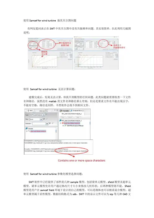
使用Samcef for wind turbine 做坎贝尔图问题
有网友提问表示在SWT中坎贝尔图中没有共振频率问题,其实很简单,在此利用几幅图说明:
使用Samcef for wind turbine 无法计算问题:
建模完成后,发现无法计算,却找不到模型的任何问题。
此类问题就需要检查一下文件名和路径,虽然没有matlab的文件名和路径那么苛刻,但还是要求文件名不能出现汉字,不能有空格,路径也同样,不然软件会找不到相应文件。
使用Samcef for wind turbine参数化模型选择问题:
SWT软件中已经提供了部件的几种sample模型,包括梁单元模型、sfield模型及超单元模型。
梁单元模型允许用户通过修改尺寸大小来修改几何形状;后两种模型则不能。
Sfield 模型是用户在samcef field环境下设计的自己的模型,可以是刚体也可以刚柔混合模型;超单元模型属于柔性模型,数据结构格式为sdb,SWT中的显示文件可以为stp等几种CAD文
件格式。
不能盲目选取samcef提供的不能修改的示例模型,不然容易引起传动链部件见的不匹配,最容易出现的是所选取的齿轮箱和底座在电机处的轴线不重合。
这样的模型是不能计算的,因为在比改变齿轮箱内部参数的情况下,无论怎么调整,仍然会出现较大误差。

SWAT模型SWAT模型是一种常用的水文模型,广泛应用于流域水文模拟和水资源管理等领域。
SWAT模型的全称是Soil and Water Assessment Tool,该模型结合了土壤、水文和气象等多方面因素,能够对流域内水文循环过程进行较为精确的模拟和预测。
在这篇文章中,我们将探讨SWAT模型的基本原理、应用范围以及未来发展方向。
SWAT模型的基本原理SWAT模型是一种基于过程的模型,其基本原理是通过对流域内水文循环过程的各种因素进行细致的建模和模拟,从而实现对流域水文过程的定量分析和预测。
SWAT模型主要考虑的因素包括降水、蒸发蒸腾、径流、土壤蓄水、植被覆盖等,模型通过对这些因素之间的相互作用进行建模,可以对流域内的水文过程进行较为准确的描述。
SWAT模型采用分布式建模方法,将流域划分为多个子集水区,然后对每个子集水区内的水文过程进行独立的模拟,最后通过整合各个子集水区的模拟结果得到对整个流域的水文过程的模拟结果。
这种分布式建模方法能够更好地考虑流域内地形、土壤和植被等空间异质性因素对水文过程的影响,提高模拟结果的准确性。
SWAT模型的应用范围SWAT模型主要应用于流域水文过程的模拟和预测,在水资源管理、土地利用规划、洪水风险评估等方面发挥着重要作用。
具体来说,SWAT模型可以用于以下几个方面:1.水资源管理:SWAT模型能够对流域内降水、径流等水文过程进行模拟,帮助决策者了解流域内水资源的分布和利用情况,指导水资源管理的决策。
2.土地利用规划:SWAT模型可以模拟不同土地利用类型对水文过程的影响,帮助规划者制定合理的土地利用规划,保护流域水资源。
3.洪水风险评估:通过模拟洪水过程,SWAT模型可以评估流域内不同地区的洪水风险,为防洪减灾提供科学依据。
4.水质预测:SWAT模型还可以模拟流域内污染物的输运过程,帮助监测人员预测流域内水质状况,保护水质。
SWAT模型的未来发展方向随着科学技术的不断发展和水资源管理需求的提高,SWAT模型也在不断完善和发展。

SWAT模型国内外研究应用现状SWAT(Soil and Water Assessment Tool)模型是一种广泛应用于水资源管理和土地利用评估的水文模型。
它是以流域为单位,模拟水文过程和土壤侵蚀等因素对水质和水量的影响。
本文将对SWAT模型在国内外的研究应用现状进行详细探讨。
首先,SWAT模型在国外的应用非常广泛。
在美国和欧洲国家,SWAT 模型已经被广泛应用于流域管理、水资源评估和农业管理等领域。
例如,在美国,SWAT模型被用于预测水资源供需、评估土地利用变化对水质的影响等。
在欧洲国家,SWAT模型也被用于评估气候变化对水文过程的影响、开展流域管理规划等。
在国内,SWAT模型的研究应用也逐渐增多。
国内研究人员主要应用SWAT模型对流域水文过程进行模拟和评估。
例如,对于黄河流域,研究人员使用SWAT模型来模拟流域水量变化、水质变化以及土壤侵蚀等影响因素,为河流水资源管理和土地利用规划提供科学依据。
此外,SWAT模型还被用于太湖流域、长江流域等地区的水资源评估和水环境监测。
此外,SWAT模型还在其他领域得到应用。
在农业管理中,SWAT模型被用于评估农田管理措施对水资源的影响。
例如,研究人员使用SWAT模型来研究不同农田管理措施对养分流失和土壤侵蚀的影响,为农田管理制定合理的措施提供参考。
在水库和河流管理中,SWAT模型也被用于评估水库运行规则对流域水量和水质的影响,为水库管理和调度提供支持。
然而,SWAT模型在研究应用过程中还存在一些问题和挑战。
首先,SWAT模型的参数估计比较困难。
模型参数数量较多,需要准确的输入数据来进行参数估计,这对数据要求较高。
其次,SWAT模型对土地利用和管理措施的响应较敏感,对于土地利用变化和管理措施的影响需要更准确的输入数据和模型参数。
此外,由于SWAT模型是基于流域尺度的模型,对于小流域研究的应用还需要进一步改进和调整。
综上所述,SWAT模型在国内外的研究应用已经取得了一定的成果,对于流域管理、水资源评估和农业管理等领域提供了科学支持。
SWAT模型降水输入参数的改进研究SWAT模型是一种广泛应用于水文模拟和水资源管理中的有力工具。
其中,降水输入参数是该模型中非常重要的一部分,对于准确模拟流域内水文过程和水资源评估具有关键作用。
然而,由于多种因素的综合影响,SWAT模型的降水输入参数存在一定的不确定性和偏差,因此有必要对其进行改进研究。
降水是流域水文过程的重要驱动力,对其准确模拟对于水文预测、洪水分析、水资源管理等非常重要。
在SWAT模型中,降水输入参数通常以日降水量的形式给定。
然而,实际观测站点的分布不均匀,且观测记录有限,导致模型在不同时空尺度上的降水输入参数选择存在困难。
另外,极端天气事件的频率和强度的变化以及气候变暖等因素也导致降水输入参数的不确定性增加。
为了改进SWAT模型的降水输入参数,研究人员提出了一系列的方法和技术。
其中一个方法是基于气象雷达和卫星遥感数据获取更精细的降水空间分布。
通过将这些数据与观测站点的降水量进行插值和校正,可以得到更准确的流域降水输入参数。
另外,气象模型的输出数据也可以用于改进降水输入参数。
大气环流模式和天气预报模型可以提供未来降水的预估,将这些预估数据与观测数据结合,可以提高降水输入参数的准确性。
除了数据来源的改进,还可以通过模型参数的优化来改善SWAT模型的降水输入参数。
对于SWAT模型中的一些关键参数,如蒸散发、河川路面面积和植被系数等,其初始值通常是通过文献回归或经验估计得到的。
然而,这些初始值可能无法准确反映流域的实际情况,因此可以通过对这些参数进行灵敏度分析和优化,得到更准确的降水输入参数。
此外,不确定性分析也是改进SWAT模型降水输入参数的重要方法之一。
不确定性通常来自于数据不确定性、模型结构和参数不确定性等方面。
通过对这些不确定性进行全面分析,可以更好地了解降水输入参数带来的影响,并进一步提高模型的准确性。
综上所述,SWAT模型的降水输入参数是影响其模拟结果准确性的重要因素之一。
arcSwat2012使用经验及困惑一使用经验1最初接触arcswat主要是看官方的视频,官方的视频看完之后,基本已经会操作了。
2 对于蒸发方式默认的是pengman公式,河道汇流演算如果想改成马根琼斯,修改bsn里可以找到。
3阅读cup使用手册。
4 观测值要去除预热期,不要包含预热期,之前我包含了预热期,也是一直出错。
2 注意的问题,(1)投影一定要选对,要知道不同的投影对流域的面积产生很大的影响,我之前用wgs_web默卡托投影就比选择albers投影大了很多。
(2)对于土地利用数据,如果自己没有做实验得来的数据,就把自己的土地利用数据按照美国的标准重新分类。
(3)土壤数据可以利用FAO的,还可以利用中科院数据中心的,比例尺都是1:100万,使用中科院数据中心的数据存在一个问题,那就是他给的数据只是到亚类,而具体的涉及土壤组成的参数必须到土种,所以需要根据土种志去寻找需要的参数,但是可能会遇到根本找不到参数的情况。
FAO数据比较方便,土壤粒径不用转换,但是只有2层数据,而且该数据跟数据中心的数据还是有很多不同的地方,大家可以仔细比对。
(4)注意FAO里的土壤深度单位是cm,而swat用的是mm。
(5)降雨站点应该选择流域内的站点,降雨站分布情况对模拟的径流有很大的影响。
(6)天气发生器制作使用群共享里的天气发生器,里面需要注意数据的格式问题,这个工具没有写数据的要求和格式,比如是否考虑了气象站数据的缺测,微量等等特殊数据。
(7)气象站数据已经有了相对湿度,平均风速,气温数据,自己利用pengman公式计算出太阳辐射。
这样就不要天气发生器了。
(8)一定要注意气象站数据的单位跟swat里的单位要统一,仔细核对数据的单位,气象站的数据单位很多都是0.1,需要除以10。
对于其他的特殊标识,一定要仔细搞清楚代表的是什么。
如果有缺测数据必须换成-99,如果有缺测的数据,那么天气发生器就必须需要了。
(9)气象数据等一定要连续,中间不能断开,比如说缺了一个月的数据,这样就不对。
SWAT模型建模中可能遇到的问题和解答ArcSWAT Frequently Asked QuestionsInstallation:1.Problem: During installation an error message containing “ … unable to get installer types …”appears, preventing successful installation.Solution: Make that the following is loaded on your system:a.) .Net Framework 2.0b.) ArcGIS DotNet Support (C:\Program Files\ArcGIS\DotNet). In order for ArcGIS DOTNetsupport to be installed, the .Net Framework 2.0 must be present on the target computer prior foinstalling ArcGIS.Solutions to Interface Problems and How-To:1.Problem: Error during Landuse/Soils/Slope overlay of “Item not found in this collection”.Cause: The SWAT2005.mdb crop or urban tables do not have a properly formatted OBJECTIDfield.Solution: Create a cop table with a sequential OBJECTID field by exporting the crop table back into the SWAT2005 database using ArcCatalog. Delete the old table and rename the new one to “crop”or “urban”2.Problem: Error at beginning of Landuse/Soils/Slope overlay operation.Possible Cause: Land use lookup codes begin with a number and not a letter. All land use lookupcodes in a user-defined landuse lookup table and also found in the crop and urban tables MUSTbegin with a letter.3. Problem: Error during watershed delineation of, “You attempted to open a database already opened…”.Cause: There is a renegade lock on a table or feature class in your SWAT project database.Solution: Close the SWAT ArcMap project. Reopen the SWAT project a try the operation again. It is a goods idea to save your SWAT project during the watershed delineation task after each step iscompleted.4.Problem: Error during the writing of SWAT input files, such as “Missing CN2 for hydrologic group…” .Cause: Soil lookup table of database usersoil table has problems.Solution: Soil names in the soil lookup and usersoil table CANNOT have “_” characters. Thesecharacters must be replaced by something else, such as “-“ or “#”.5.Problem: Errors while reading in observed weather filesCause: Make that there are no extra empty rows at the end of the tables. Also, check observed datafiles to make sure that there are no dates that are skipped in the middle of the file.6.Question: Observed weather data was loaded. However, during model setup, I can only select a simulation period that falls within the dates of my observed data. How setup a model “warm-up”period using simulated weather?Answer: You must add missing data values to the beginning of at least 1 of your observed weatherfiles. This will allow the model setup dates to span a wider range, allowing several years of “warm-up” prior to the observed data.7.Question: How to copy a SWAT project manually:1.) Copy the entire project folder to a new location.2.) Open up the SWAT project .mdb database (in new folder) using MS Access.3.) Open "MasterProgress" table. Update the "WorkDir" field to reflect the new project folder path.4.) Open the SWAT .mxd document in new project folder. It should be all set, and point to newfolder8.Problem: Some interface forms crash when exiting OR the help system does not work.Cause: Adobe Acrobat Reader version 8.0 or higher must be installed.9.Problem: I get an error loading my weather station dBase files.Cause: On some operating systems, the length of the dBase file name must be 8 characters or less(plus the extension). By making your station list table and the individual station table files withnames of less than 8 characters, this error should be resolved.10.Problem: When using user-defined watersheds option, ArcSWAT fails when writing the MGT filesusing the Heat Units calculator option.Cause: A likely cause is that the user watershed and/or stream dataset did not their projection defined.This will cause the heat unit calculator program to crash. Define the projection for the userwatersheds/streams datasets, then re-import through the watershed delineation interface. ArcSWAT Databases: 1.Question: The ArcSWAT project databases contain an “ArcHydro” feature dataset where the final watershed delineation datasets are stored. This structure does not match the standard ArcHydro geodatabase model. Why not?Answer: The ArcSWAT “ArcHydro” feature dataset contains feature classes that follow closely thestandard ArcHydro model, but not completely. These feature classes can be readily imported into astandard ArcHydro geodatabase.2.Question: In my SWAT project database, there are more records in the “hru” table than are found inthe spatial HRU layer, “Full_hru”. Why is this?Answer: In there are split HRUs into sub-hrus, then there will always be more records in the “hru”table than in the spatial layer. This is because we have made multiple tabular hrus out of a singlespatial hru.3.Question: In my SWAT project database, there are fewer records in the “hru” table than are found inthe spatial HRU layer, “Full_hru”. Why is this?Answer: In some cases, a land use or soils lookup table may have more than 1 value representing the same land use or soils class. In these cases, the spatial hru layer generated will have a single polygon for each unique combination of the raw dataset values, not the lookup values. However, in the hrutable, unique combinations that have the same lookup values will be combined into a single hru. Good Practices to Prevent Crashes:1.Unexplained crashing: Periodically, use the “Compact Database” function in ArcCatalog to compactthe SWAT Project geodatabase. This database can approach the 2 GB limit when working with very large datasets. Unexplainable crashes will occur when using the interface is this 2 GB limit isreached.2.Crashing during LU/Soils definition: Some ArcInfo coverage format soils or land use datasets mayresult in errors in the HRU analysis functions. It is best to use shapefile or ESRI grid formatdatasets.3.Crashing when using user-defined watersheds/streams: When using user-defined watersheds andstreams, the input watersheds and streams datasets must have exactly the same fields as defined inthe user documentation (Section 3 page 14). Otherwise, errors may result.Land Use/Soil/Slope Overlay Problems:1.If you manually re-assign a land use in the “SWAT Land Use Classification Table”, and you choosea land use class that is already assigned in the table, then you will experience a crash during theoverlay operation. The land use classes listed in the “SWAT Land Use Classification Table” must be unique prior to performing the overlay. The solution to this issue is to modify your land use lookup table so that multiple grid codes get assigned to the same SWAT land use class. In this case, theinterface will automatically reclassify the land use dataset based on the lookup table, resulting inunique lands use values in the “SWAT Land Use Classification Table”. NOTE: This same concept applied to the soils data as well.。
使用SWAT模型时的一些常见小问题汇总
使用SWAT模型时的一些常见小问题汇总
使用SWAT模型过程发现了很多小问题,自己摸索时也浪费了不少时间,现总结下,希望对后学者有点帮助。
1. 要将区域语言改为英语,不要用中文,否则无法启动。
2. 最好关掉卡巴,否则可能导致无法加载。
3. 加载扩展模块时,不要点“设置为默认”,否则会出错。
4. 加载DEM时,要定义投影,最好点修改确认是否已经定义投影。
5. 完成流域提取后,会自动生成很多结点,包括河道汇合点等等,如果结点太密集,最好手动删除一些,否则可能导致在加载土地利用和覆被时出现error。
6. 如果run的过程中出现error,打开一个arrange.log文件(自己在文件夹中找),看看是不是有些参数范围设置有问题。
7. 还有可能是txtin文件有错误(错误的话里面会有无法识别的*号),打开自己修正。
8. 仔细看输入文件说明,保证所有数据文件齐全并且格式正确。
还有其它一些问题暂时没有想起来,等遇到的时候再来补充。
如果大家有问题并且已经找到了解决办法,可以一起交流,共同学习。
ArcSWAT Frequently Asked QuestionsInstallation:1.Problem: During installation an error message containing “ … unable to get installer types …”appears, preventing successful installation.Solution: Make that the following is loaded on your system:a.) .Net Framework 2.0b.) ArcGIS DotNet Support (C:\Program Files\ArcGIS\DotNet). In order for ArcGIS DOTNetsupport to be installed, the .Net Framework 2.0 must be present on the target computer prior foinstalling ArcGIS.Solutions to Interface Problems and How-To:1.Problem: Error during Landuse/Soils/Slope overlay of “Item not found in this collection”.Cause: The SWAT2005.mdb crop or urban tables do not have a properly formatted OBJECTIDfield.Solution: Create a cop table with a sequential OBJECTID field by exporting the crop table back into the SWAT2005 database using ArcCatalog. Delete the old table and rename the new one to “crop”or “urban”2.Problem: Error at beginning of Landuse/Soils/Slope overlay operation.Possible Cause: Land use lookup codes begin with a number and not a letter. All land use lookupcodes in a user-defined landuse lookup table and also found in the crop and urban tables MUSTbegin with a letter.3. Problem: Error during watershed delineation of, “You attempted to open a database already opened…”.Cause: There is a renegade lock on a table or feature class in your SWAT project database.Solution: Close the SWAT ArcMap project. Reopen the SWAT project a try the operation again. It is a goods idea to save your SWAT project during the watershed delineation task after each step iscompleted.4.Problem: Error during the writing of SWAT input files, such as “Missing CN2 for hydrologic group…” .Cause: Soil lookup table of database usersoil table has problems.Solution: Soil names in the soil lookup and usersoil table CANNOT have “_” characters. Thesecharacters must be replaced by something else, such as “-“ or “#”.5.Problem: Errors while reading in observed weather filesCause: Make that there are no extra empty rows at the end of the tables. Also, check observed datafiles to make sure that there are no dates that are skipped in the middle of the file.6.Question: Observed weather data was loaded. However, during model setup, I can only select asimulation period that falls within the dates of my observed data. How setup a model “warm-up”period using simulated weather?Answer: You must add missing data values to the beginning of at least 1 of your observed weatherfiles. This will allow the model setup dates to span a wider range, allowing several years of “warm-up” prior to the observed data.7.Question: How to copy a SWAT project manually:1.) Copy the entire project folder to a new location.2.) Open up the SWAT project .mdb database (in new folder) using MS Access.3.) Open "MasterProgress" table. Update the "WorkDir" field to reflect the new project folder path.4.) Open the SWAT .mxd document in new project folder. It should be all set, and point to newfolder8.Problem: Some interface forms crash when exiting OR the help system does not work.Cause: Adobe Acrobat Reader version 8.0 or higher must be installed.9.Problem: I get an error loading my weather station dBase files.Cause: On some operating systems, the length of the dBase file name must be 8 characters or less(plus the extension). By making your station list table and the individual station table files withnames of less than 8 characters, this error should be resolved.10.Problem: When using user-defined watersheds option, ArcSWAT fails when writing the MGT filesusing the Heat Units calculator option.Cause: A likely cause is that the user watershed and/or stream dataset did not their projection defined.This will cause the heat unit calculator program to crash. Define the projection for the userwatersheds/streams datasets, then re-import through the watershed delineation interface. ArcSWAT Databases:1.Question: The ArcSWAT project databases contain an “ArcHydro” feature dataset where the finalwatershed delineation datasets are stored. This structure does not match the standard ArcHydrogeodatabase model. Why not?Answer: The ArcSWAT “ArcHydro” feature dataset contains feature classes that follow closely thestandard ArcHydro model, but not completely. These feature classes can be readily imported into astandard ArcHydro geodatabase.2.Question: In my SWAT project database, there are more records in the “hru” table than are found inthe spatial HRU layer, “Full_hru”. Why is this?Answer: In there are split HRUs into sub-hrus, then there will always be more records in the “hru”table than in the spatial layer. This is because we have made multiple tabular hrus out of a singlespatial hru.3.Question: In my SWAT project database, there are fewer records in the “hru” table than are found inthe spatial HRU layer, “Full_hru”. Why is this?Answer: In some cases, a land use or soils lookup table may have more than 1 value representing the same land use or soils class. In these cases, the spatial hru layer generated will have a single polygon for each unique combination of the raw dataset values, not the lookup values. However, in the hrutable, unique combinations that have the same lookup values will be combined into a single hru. Good Practices to Prevent Crashes:1.Unexplained crashing: Periodically, use the “Compact Database” function in ArcCatalog to compactthe SWAT Project geodatabase. This database can approach the 2 GB limit when working with very large datasets. Unexplainable crashes will occur when using the interface is this 2 GB limit isreached.2.Crashing during LU/Soils definition: Some ArcInfo coverage format soils or land use datasets mayresult in errors in the HRU analysis functions. It is best to use shapefile or ESRI grid formatdatasets.3.Crashing when using user-defined watersheds/streams: When using user-defined watersheds andstreams, the input watersheds and streams datasets must have exactly the same fields as defined inthe user documentation (Section 3 page 14). Otherwise, errors may result.Land Use/Soil/Slope Overlay Problems:1.If you manually re-assign a land use in the “SWAT Land Use Classification Table”, and you choosea land use class that is already assigned in the table, then you will experience a crash during theoverlay operation. The land use classes listed in the “SWAT Land Use Classification Table” must be unique prior to performing the overlay. The solution to this issue is to modify your land use lookup table so that multiple grid codes get assigned to the same SWAT land use class. In this case, theinterface will automatically reclassify the land use dataset based on the lookup table, resulting inunique lands use values in the “SWAT Land Use Classification Table”. NOTE: This same concept applied to the soils data as well.。