LandStar7软件使用说明书
- 格式:doc
- 大小:100.97 MB
- 文档页数:73

LandMark软件常规解释流程培训资料(内部使用)杜振京二00五年六月目录一、数据加载 (1)(一)启动LandMark (1)(二)建立投影系统 (1)(三)建立OpenWorks数据库 (1)(四)加载钻井数据 (1)二、制作合成地震记录 (5)(一)准备工作 (5)(二)启动SynTool制作合成地震记录 (5)(三)合成地震记录的存储 (7)(四)合成地震记录的输出 (7)三、三维地震资料解释 (8)(一)启动SeisWorks模块 (8)(二)三维地震工区中常见的文件类型 (8)(三)显示工区底图 (8)(四)显示地震剖面 (9)(五)解释层位和断层 (9)(六)制作等值线,生成绘图文件(*.cgm)并出图 (9)(七)层位管理 (10)四、时深转换 (12)(一)建立速度模型 (12)(二)时深(或深时)转换 (14)(三)速度模型的输出及其应用 (17)(四)基准面 (19)五、构造成图 (21)(一)作图前的准备工作 (21)(二)用ASCII数据绘制等值线平面图 (22)(三)用SeisWorks解释数据绘制等值线平面图 (23)(四)绘制地理底图 (24)(五)生成比例绘图文件(*.cgm)并出图 (27)六、UNIX常用命令介绍 (28)(一)目录管理命令 (28)(二)文件管理命令 (28)(三)打印命令 (30)(四)网络操作 (30)(五)其他常用命令 (30)(六)vi编辑命令 (31)应用LandMark软件进行常规地震资料解释OpenWorks是LandMark所有软件模块的一体化工作平台。
在此环境平台下,地球科学应用人员可以直接综合应用各种软件模块,解决各种地学问题。
在LandMark软件中进行地震资料解释的常规流程如下:●数据加载●制作合成地震记录●三维地震资料解释●时深转换●构造成图一、数据加载(一)启动LandMark进入LandMark用户后即刻出现OpenWorks工作平台, LandMark软件各种功能的模块(SynTool、SeisWorks、TDQ、ZmapPlus、PostStack/PAL。

1Enter RV information and access RV-specifi c tools.2Show location on the map and view navigation instructions.3Choose a destination.4 Select general, route, and map preferences.Note: Some icons may not be present, depending on specifi c hardware. Main Menu 12341. Tap RV T ools > RV Info or Warnings.2. Tap and to view options.3. Tap the option button to be changed.4. Enter new settings.5. Tap to save changes.1. Tap Preferences .2. Tap the General , Route or Map tab.3.Tapand to view options.4. Tap the option button to be changed.5.Enter new settings.6. Tap to save changes.Enter RV Information and Set Warnings Set Routing and Device Options Destination1Return to a new location.2Return to a previously entered address.3Access the Address Book.4Plan a multi-stop trip. 5 Route to a point of interest.6 Run an Internet search for local businesses.(Note: This feature requires a Wi-Fi connection.)7 View trip content from Rand McNally.Run a local search near:8 Your RV9 A particular city10 Your destination 11 Search for local restaurants.12Access recent searches. 123456*********Route to a Destination1. Tap Choose Destination > New Location .2. Tap Address .3. Enter the name of the city. (Note: As you type, the keyboard displaysonly the next possible letter.)4. Prompts appear in the top bar. Tap the city to select. Or, tap List toview cities beginning with the letter(s) you entered.5. Enter the street name. (Note: If the letters you need do not appear,tap Expand Search.)6. Enter the house number. (Note: To enter the house number before the street, tap the house number button in the previous step.)Confi rm Destination Window1Destination address.2Begin route to destination.3Compare a primary and alternate route and choose one.4Add the location as a via point on the way to a previously entered destination.*5Save the location to the Address Book.6Cross reference to printed Rand McNally Road Atlas.7View the map.8Change the starting location for a route to the location displayed here.9View the map.10 Return to previous window.*To manage via points, Tap Choose Destination > Multi-Stop T rips .You can add up to 50 destinations in a multi-stop trip, and optimize routing for trips of up to 10 stops.NOTE: This window may include additional buttons based on the type of destination selected.14679810325See Confi rm Destination Window.T ips• You can also route to a new location by City Center , Intersection ,or Latitude/Longitude , or choose Address > Zip Code Search .• View recent destinations by tapping Choose Destination > History .View recent cities by tapping Choose Destination > New Location >Address > History .• View saved locations by tapping Choose Destination > Address Book .Repeat spoken next-maneuver instructions.2 Name of street you will turn onto next.3 Show arrival time, remaining time, or other options. 4Slide out to show upcoming exit information.5 Directions list slideout. Tap Route Display Optionsto select turn-by-turn, highway, trip summary, or summary map view. 6Zoom in/zoom out.7 Access Wi-Fi connected services.8 Return to Main Menu.9 Select a map display option (Heading Up, North Up, or 3D View).Also displays Wi-Fi status.10 View current road name, upcoming cross road name, or city, county and state.11 View and save current location, detour or cancel a route, or skip to the next stop.12 Tap on the current speed to display the Virtual Dashboard.Note: Turns red for speed warnings; set in RV T ools > Warnings .)13Current speed limit. Tap to open a “Tell Rand” about speed limits.14 View the Traffi c Window (enabled with Traffi c Everywhere).15 Mute or unmute the speaker.Route Map Window R 1134568792101112151413When on a route, Junction View displays when you have an upcomingmaneuver. Once past the maneuver, Junction View closes and theprevious window displays.1Signs to follow for the next maneuver.2Number and direction of lanes for the next maneuver.3 Distance to the upcoming maneuver. Distance decreases as youapproach the ramp.4 Lane assist arrow.5 Mute the speaker.6 Return to previous window.Junction View123456Tap Choose Destination > Points of Interest .1Find popular RV-friendly POIs near your current location.Search for a POI:2Near your RV 3In a particular city 4Along your route 5Near your destination POI Categories:6Select a category.7Find restaurants, hotels, and other subcategories.8View custom POIs such as red light cameras or other locations that have beenuploaded through the Rand McNally Dock.9Tap location to select.10View and edit ratings and comments.11Tap to search by available services.12Apply or remove services fi lter for search results.76813452Find a Point of Interest (POI)91011121Sunrise and sunset times based on vehicle location(latitude/longitude) and day.2Current speed.3 Elevation at current location.4 Percentage of current trip completed, distance to next maneuver, and the number of miles and time spent on the trip to this point.5 Match with the vehicle’s odometer to automatically update newfuel logs. Tap the pencil to edit.6 Gather trip information for up to three trips. Includes odometer settings, hours, and speeds.7 Reset trip information for the selected trip (Tab 1, Tab 2 or Tab 3).8 Select to automatically reset the information in each tab after the vehicle has remained stationary for the specifi ed number of hours.9 View fuel logs and add fuel purchase information.10 Return to the Route Map Window .134568792Virtual Dashboard10Tap RV T ools > Checklists, Maintenance, Trails, Fuel . Then tap on each tab to view.1Use Checklists to create and complete task lists to prepare for a trip.2Add notes in the Maintenance tab to record dates of service for your RV .3 Use Trails to record a “bread-crumb” path of GPS coordinateswhere your RV has traveled. Tap any record to view the trail, edit the name, or set the color.4 Use the Fuel tab to view a list of fuel purchases. Tap Add Fuelto record the date, location and cost of fuel purchase. Tap Save .Tap any record to make changes. (Note: This can be exported to your PC or Mac via the Rand McNally Dock.)Checklists, Maintenance, Trails, and Fuel 1234For information on setting up a Wi-Fi hotspot through your cellular phoneor laptop computer, please visit /wifi help forbasic instructions or contact your wireless carrier.Note: Wi-Fi connectivity requires a supporting feature and data planfrom your wireless service provider.As the user, you are responsible for all data charges. Please contact your wireless service provider to make sure you do not exceed thelimits of your data plan.Once you have established a Wi-Fi hotspot:1. From the Main Menu, tap Preferences.2. Tap WiFi in the bottom right corner.3. Tap Enable WiFi to search for available hotspots.4. Tap the hotspot you want to connect to.5. Enter the network password.6. Tap Disable WiFi to turn Wi-Fi connectivity off.Wi-Fi ®Weather, Fuel Prices, and Traffi c EverywhereNote : This feature requires a Wi-Fi connection.Tap the Wi-Fi connected services icon( ) on the map screen. Tap each tab to view live information.Weather:1Tap to view details for current weather alerts.2View weather information at your destination.3 Display weather on the map as you drive.Fuel Prices:4Check to show fuel prices on the map screen.5Sort results by distance or price.6Set fi lters for type and brand of fuel.7 Choose to search near your vehicle or along your route.Traffi c Everywhere:Live traffi c information is available as a premium service on theRand McNally Dock.4513267The Rand McNally Dock enables you to receive software upgrades and access map updates, monthly construction updates, and additional features. Simply download the Dock software for your PC or Mac at /dock, remove the SD card from your device and insert it into your PC or Mac using SD card adapter. Then start the Rand McNally Dock software.With the Rand McNally Dock, you can also:•Access the TripMaker ® Trip Planner •Purchase Traffi c Everywhere •Upload custom POIs, such as red light cameras and railroad crossings, to your device •Download the User Manual •Access the Rand McNally support site and online store •Read product news and announcements • Send feedback and suggestions to Rand McNally through “Tell Rand”For a detailed description of the features of your device, please see the RVND TM 7730 User Manual. The User Manual can be downloaded from the Rand McNally Dock, and is also available at /support .More InformationRand McNally Dock ™Warnings, End-User License Agreement, and WarrantyPay attention to road conditions and street signs, and obey all traffic and safety laws. Traffic laws and current traffic conditions must always be observed and take precedence over the instructions issued by the Rand McNally navigation system. The User should be aware of situations where current traffic conditions and the instructions from the navigation system may be in conflict. Some states prohibit the use of windshield mounts and may otherwise restrict the usage of navigation and other electronic devices in the vehicle. It is the User’s responsibility to ensure compliance with all laws and regulations. The use of the navigation system does not relieve the User of his/her responsibilities. The User is ultimately responsible for the vehicle under his/her control and should be aware of the surroundings at all times.If after reading these statements the User decides not to accept these terms, the User should not use the navigation system.Rand McNally hereby grants you (“User”) a single-user non-exclusive, non-transferable license to use the Rand McNally navigation system (hereinafter referred to as the “Product” (including software and associated data)) for User’s own internal business or personal use and not for resale, sublicense or commercial use.This Product and the software incorporated in it and related documentation are furnished under license and may be used only in accordance with this license. Except as permitted by such license, the contents of this Product and software may not be disclosed to third parties, copied or duplicated in any form, in whole or in part, without the prior written permission of Rand McNally. This Product and software contain proprietary and confidential information of Rand McNally and its licensors. Rand McNally grants User a limited license for use of this Product and the software incorporated in the Product for its normal operation. By using the Product, User acknowledges that the content of this document and the Product are the property of Rand McNally and its licensors and are protected by U.S. copyright, trademark and patent laws and international treaties.THE USER MAY NOT:• Use the Product on a network or file server, time-sharing or to process data for other persons.• Use the Product to create any routing tables, files, databases or other compendiums.• Copy, loan or otherwise transfer or sublicense the Product, its software or content.• Modify, or adapt the Product in any way, or decompile, disassemble, reverse engineer or reduce to human readable form the Product and software incorporated therein.• Alter, remove or obscure any copyright notice, trademark notice, or proprietary legend from the Product, its software or content.This license will terminate automatically if User fails to comply with any of the terms of this license and User agrees to stop using the Product. Rand McNally may revise or update the Product and is not obligated to furnish any revisions or updates to User.Caution: Rand McNally makes no warranty as to the accuracy or completeness of the information in the Product and disclaims any and all express, implied or statutory warranties, including any implied warranty of merchantability or fitness for a particular purpose. It is the user’s responsibility to use this product prudently. This product is intended to be used only as a travel aid and must not be used for any purpose requiring precise measurement of direction, distance, location or topography.RAND MCNALLY AND ITS LICENSORS DO NOT MAKE ANY OTHER WARRANTY OR REPRESENTATION, EITHER EXPRESS OR IMPLIED, WITH RESPECT TO THE PRODUCT, INCLUDING ANY WARRANTY AS TO QUALITY, PERFORMANCE, TITLE OR NON-INFRINGEMENT. IN NO EVENT WILL RAND MCNALLY OR ITS LICENSORS BE LIABLE FOR ANY INDIRECT, SPECIAL, INCIDENTAL, OR CONSEQUENTIAL DAMAGES ARISING OUT OF THE USE OR INABILITY TO USE THE PRODUCT, EVEN IF ADVISED OF THE POSSIBILITY OF SUCH DAMAGES.Some states do not allow limitations on how long an implied warranty lasts and/or do not allow the exclusion or limitation of incidental or consequential damages, so the above limitations may not apply to some consumers.The User agrees to allow User-provided information to Rand McNally to be used for internal business evaluation purposes, including, but not limited to, evaluating the effectiveness of the services provided, methods to simplify or improve User experiences. Such information will not be used by third parties or in any way that discloses the identity of the User.Rand McNally may make use of third party software in the Product. Notwithstanding the terms and conditions of this license, use of some third party materials included in the Product may be subject to other terms and conditions. The official third party copyright notices are provided at the end of this License.The User agrees to indemnify, defend and hold Rand McNally and its licensors (including their respective licensors, suppliers, assignees, subsidiaries, affiliated companies, and the respective officers, directors, employees, shareholders, agents and representatives of each of them) free and harmless from and against any liability, loss, injury (including injuries resulting in death), demand, action, cost, expense or claim of any kind or character, including but not limited to attorney’s fees, arising out of or in connection with any use or possession by the User of this Product.These terms and conditions constitute the entire agreement between Rand McNally (and its licensors and suppliers) and the User pertaining to the subject matter hereof, and supersedes in their entirety any and all written or oral agreements previously existing between us with respect to such subject matter.The above terms and conditions shall be governed by the laws of the Illinois, without giving effect to (i) its conflict oflaws provisions, or (ii) the United Nations Convention for Contracts for the International Sale of Goods, which is explicitly excluded. The User agrees to submit to the jurisdiction of Illinois for any and all disputes, claims and actions arising from or in connection with the Data provided to the User hereunder.User shall not export the Product in violation of any U.S. or foreign laws. Rand McNally’s licensors shall be third party beneficiaries of Rand McNally’s rights under this license, but are not parties hereto and have no obligations hereunder.By using this product you agree to be bound both by the foregoing and to the terms of use found at www. /RVGPS.Actual toll costs may vary from estimates depending upon a number of factors including inaccurate or imprecise source data and upon variable toll costs which are dependent upon vehicle characteristics (class, axle number, weight, etc.) that vary across toll roads.Restricted Rights Legend. For governmental agencies: Use, reproduction or disclosure is subject to restrictions set forth in subparagraph (c) (1) (iii) of the Right in Technical Data and Computer Software clause at DFARS 52.227-7013, as amended.Rand McNally and the globe logo are registered trademarks and RVND is a trademark of RM Acquisistion, LLC. The Good Sam logo is a registered trademark of Good Sam Enterprises, LLC. The term Wi-Fi® is a registered trademark of the Wi-Fi Alliance®. CityGrid is a registered trademark of CityGrid Media.Copyright © 2014 Rand McNally. Portions © 2014 HERE. This data includes information taken with permission from Canadian authorities, including © Her Majesty the Queen in Right of Canada, © Queen’s Printer for Ontario. © 2014 Allstays, LLC. © 2014 . © 2014 Fishing Hot Spots, Inc. © 2014 InfoGation.© 2014 . © 2014 The RVer’s Friend. © 2014 Good Sam Enterprises, LLC. © 2014 CityGrid.© 2014 . Traffic information provided by INRIX. © 2014 INRIX, Inc. All rights reserved. U.S. Patent Nos. 7,580,791 and 8,214,141.Support/support 800-333-0136。
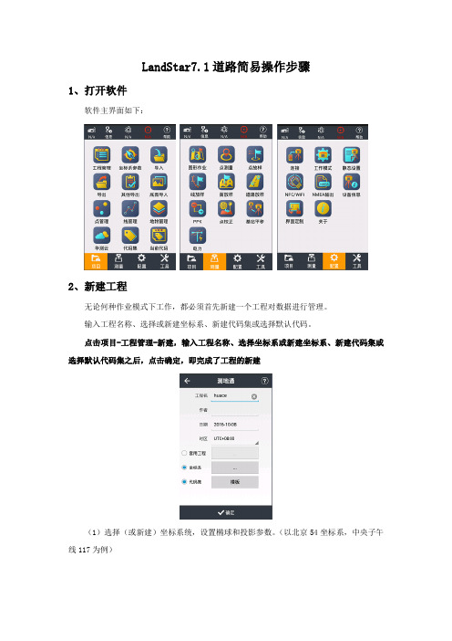
LandStar7.1道路简易操作步骤1、打开软件软件主界面如下:2、新建工程无论何种作业模式下工作,都必须首先新建一个工程对数据进行管理。
输入工程名称、选择或新建坐标系、新建代码集或选择默认代码。
点击项目-工程管理-新建,输入工程名称、选择坐标系或新建坐标系、新建代码集或选择默认代码集之后,点击确定,即完成了工程的新建(1)选择(或新建)坐标系统,设置椭球和投影参数。
(以北京54坐标系,中央子午线117为例)(2)选择(或新建)代码3、连接仪器点击配置-连接厂商(华测)、设备类型(i80\X10\T8\T7\M6等智能机选择“智能RTK”,其他机型选择“GNSS RTK”)连接方式:智能RTK可使用WiFi和蓝牙,GNSS RTK选择蓝牙连接热点或目标蓝牙:在系统配置好蓝牙(密码1234)或WiFi(默认密码12345678),设备名称为设备SN号(SN号在接收机底部标签上)天线类型:选择对应仪器型号完成后点击连接按钮4、设置基准站或移动站⑴内置电台1+N模式(作业距离短,一般小于3公里使用)连接基准站,进入“配置-工作模式”,选择“默认:自启动基准站-内置电台”点击“接受”;连接移动站,选择“默认:自启动移动站-华测电台”(此时基站移动站使用电台信道7,频率461.050MHz通讯)点击“接受”⑵外挂电台1+N模式连接基准站,进入“配置-工作模式”,选择“默认:自启动基准站-外挂电台”点击“接受”,设置外挂电台为信道7(频率461.050MHz);连接移动站,选择“默认:自启动移动站-华测电台”点击“接受”。
⑶网络1+N模式连接基准站,进入“配置-工作模式”,选择“默认:自启动基准站-内置网络+外挂电台”点击“接受”(没接外挂电台移动站仅网络可用,接了外挂电台并设置信道7,频率461.050MHz,移动站网络与电台都可用);连接移动站,选择“默认:自启动移动站-Apis 网络”点击“接受”,在弹出的输入基站SN号中输入基准站SN号(SN号在接收机底部标签上)。
Landsat-7产品介绍数据处理部林友明研究员美国的陆地卫星7(Landsat-7)于1999年4月15日发射升空后,由于其优越的数据质量,以及与以前的Landsat系列卫星保持了在数据上的延续性,现在已成为中国遥感卫星地面站的主要产品之一。
在数据产品方面,Landsat-7与Landsat-5的最主要差别有:增加了分辨率为15米的全色波段(PAN波段);波段6的数据分低增益和高增益数据,分辨率从120米提高到60米。
本文介绍了Landsat-7产品按产品处理级别和产品范围的分类、定标参数文件的更新。
最后,介绍确定的星历数据在Landsat-7数据预处理系统中的使用及其对产品质量的影响。
按产品处理级别分类1.原始数据产品(Level 0)原始数据产品是卫星下行数据经过格式化同步、按景分幅、格式重整等处理后得到的产品,产品格式为HDF格式,其中包含用于辐射校正和几何校正处理所需的所有参数文件。
原始数据产品可以在各个地面站之间进行交换并处理。
2.系统几何校正产品(Level 2)系统几何校正产品是指经过辐射校正和系统级几何校正处理的产品,其地理定位精度误差为250米,一般可以达到150米以内。
如果用确定的星历数据代替卫星下行数据中的星历数据来进行几何校正处理,其地理定位精度将大大提高。
几何校正产品的格式可以是FAST-L7A格式、HDF格式或GeoTIFF 格式。
3.几何精校正产品(Level 3)几何精校正产品是采用地面控制点对几何校正模型进行修正,从而大大提高产品的几何精度,其地理定位精度可达一个象元以内,即30米。
产品格式可以是FAST-L7A格式、HDF格式或GeoTIFF格式。
4.高程校正产品(Level 4)高程校正产品是采用地面控制点和数字高程模型对几何校正模型进行修正,进一步消除高程的影响。
产品格式可以是FAST-L7A格式、HDF格式或GeoTIFF格式。
要生成高程校正产品,要求用户提供数字高程模型数据。

在此版本中有什么新的?修订历史7.2.0------------ 增加支持麦克风校正曲线(仅在这个版本的幅度)- 新增功能的首选地块,允许多个相同类型的图表显示,在各种不同的数据痕迹。
- 新增显示/捕获所有类型的痕迹(频谱或转让fuction)没出现- 增加了数据交换的API V1.0- 增加了频谱和传递函数的痕迹峰值追踪- 增加了光标读数频率波长和注意ID- 增加了用户指定的发车间隔为RTA和传递函数(幅度和相位)图- 重新音频IO的对话框,以支持新的功能,并使其功能更清晰- 更名为音频IO的音频设备选项的对话框,希望缓解了一些混乱,有关它的功能- 更名为集团经理测量配置,以更好地反映其功能- 光标读数现在跟踪显示的幅度倒幅度的痕迹(而不是原来的uninverted值)- 增加了“常规”选项卡“选项”对话框- 移动迹线的厚度,在“选项”对话框“常规”选项卡- 移动速度的声音在“选项”对话框“常规”选项卡- 过载阈值改为3个或更多的连续> / = 99%满量程(100%)- 信号电平/声级计重置为0.0当设备改为无- 修正:实时频谱平均测量现在荣誉校准偏移,如果所有参与者进行校准- 修正:修正关闭,由一个错误在用户自定义色板存储- 错误修复:一个平均痕迹复制ASCII函数的问题已得到纠正- 错误修复:捕捉平均跟踪正常工作时选择包括标准和生活的平均传递函数的痕迹- 修正:修正错误就错误跟踪行动显示/隐藏的变化7.1.2------------ 固定的问题,关于在MacOS X 10.6的通用USB音频编解码器设备。
- 固定的参考跟踪,通过跟踪数据管理信息“对话框中保存的文件被删除,从数据管理器”面板中删除时,相应的静态跟踪对象的错误,造成。
- 增加了复位配置功能(通过“文件”菜单访问)。
- 固定与固定在硬件比48K其他任何在MacOS X 10.6.5或更高的采样率的设备的问题。
- Mac版本现在支持为Windows(如适用)相同的采样率。
LandStar7软件使用技术指导文件LandStar7概述本章节推荐●软件简介●软件桌面●软件安装软件简介软件桌面LandStar7软件主桌面分为4个页面:【项目】【测量】【配置】【工具】。
启动桌面:在某台安卓设备上,首次安装运行本软件,会直接进入主桌面。
依次滑动进入下一页。
状态栏:【】:接收机电池的电量。
【】:设备信息,点击可查看当前设备的详细信息。
【】:N/A,A表示接收卫星的总数;N表示有效解算的卫星数。
【】:单点状态,点击该标志可以查看DOP信息及位置信息。
【】:浮动状态,点击该标志可以查看DOP信息及位置信息。
【】:固定状态,点击该标志可以查看DOP信息及位置信息。
【精度】:H:平面精度。
V:高程精度。
RMS:相对中误差。
1、设备信息点击“状态栏”,可以查看当前设备的详细信息。
如下图所示:详细内容请参照章节2.52、星空图点击“状态栏”可以打开星空图显示桌面,点击星空图桌面“列表”可以查看当前卫星信息。
点击卫星信息列表桌面“星空图”可以返回星空图桌面。
星空图:显示当前星空图各卫星的参考位置信息。
不同颜色代表不同卫星系统,同时在星空图下方用双向柱状图显示L1、L2信噪比。
柱状图颜色代表不同信噪比范围: 信噪比≤20 显示绿色。
20<信噪比≤40 显示蓝色。
卫星信息列表:点击“列表”进入卫星信息列表,显示当前搜到的各卫星编号、卫星系统、L1\L2\L5信噪比、高度角、方位角、锁定情况等信息。
卫星号:星座 卫星号范围 GPS 1-32 SBAS 120-138 GLONASS 38-61 BDS161-1903、精度包括位置信息,精度和DOPs 值信息。
位置:解算状态(单点、浮动或固定)。
当前位置WGS84坐标。
GPS进度。
差分延迟。
精度:H,V,RMS。
DOPs:表示当前卫星搜索状态的空间精度因子,包含PDOP、HDOP、VDOP、TDOP和GDOP 五个值。
点击【】,当前WGS84坐标转换成WGSXYZ、本地BLH、本地XYZ,坐标值可相互转换。
LandStar7软件使用说明书LandStar7概述本章节介绍●软件简介●软件界面●软件安装软件简介软件界面LandStar7软件主界面分为4个页面:【项目】【测量】【配置】【工具】。
启动界面:在某台安卓设备上,首次安装运行本软件,会直接进入主界面。
依次滑动进入下一页。
➢状态栏:【】:接收机电池的电量。
【】:设备信息,点击可查看当前设备的详细信息。
【】:N/A,A表示接收卫星的总数;N表示有效解算的卫星数。
【】:单点状态,点击该标志可以查看DOP信息及位置信息。
【】:浮动状态,点击该标志可以查看DOP信息及位置信息。
【】:固定状态,点击该标志可以查看DOP信息及位置信息。
【精度】:H:平面精度;V:高程精度;RMS:相对中误差。
1、设备信息点击“状态栏”,可以查看当前设备的详细信息。
如下图所示:详细内容请参照章节2.52、星空图点击“状态栏”可以打开星空图显示界面,点击星空图界面“列表”可以查看当前卫星信息。
点击卫星信息列表界面“星空图”可以返回星空图界面。
星空图:显示当前星空图各卫星的参考位置信息。
不同颜色代表不同卫星系统,同时在星空图下方用双向柱状图显示L1、L2信噪比。
柱状图颜色代表不同信噪比范围:信噪比≤20 显示绿色;20<信噪比≤40 显示蓝色;卫星信息列表:点击“列表”进入卫星信息列表,显示当前搜到的各卫星编号、卫星系统、L1\L2\L5信噪比、高度角、方位角、锁定情况等信息。
卫星号:星座卫星号范围GPS 1-32SBAS 120-138GLONASS 38-61BDS 161-1903、精度包括位置信息,精度和DOPs值信息。
位置:解算状态(单点、浮动或固定);当前位置WGS84坐标;GPS时间;差分延迟;精度:H,V,RMS;DOPs:表示当前卫星搜索状态的空间精度因子,包含PDOP、HDOP、VDOP、TDOP和GDOP 五个值。
点击【】,当前WGS84坐标转换成WGSXYZ、本地BLH、本地XYZ,坐标值可相互转换。
➢标题栏可以显示当前打开项目的项目名称和打开程序所在的项目。
➢菜单栏显示项目包含的各个功能项目,如工程模块、测量模块、工具模块、配置模块等。
软件安装将软件LandStar7程序(*.apk)拷贝至安卓设备上,触屏点击程序开始安装,程序安装成功,在桌面上出现LandStar7程序图标。
一、项目本章节介绍:●工程管理●坐标系参数●导入●导出●其他导出●底图管理●点管理●线管理●地物管理●华测云●代码管理●工程代码1.1工程管理在主界面项目页点击【工程管理】进入工程管理界面,对工程进行管理,如图1-1所示。
图1-11.1.1新建无论何种作业模式下工作,都必须首先新建一个工程对数据进行管理。
点击【新建】,弹出新建工程对话框,如图1-2所示。
图1-2 图1-3在“工程名”中输入工程名称;“作者”中输入操作员的姓名;“日期”默认是当地时间;“时区”是指当地时间和GPS时间相差的时区,可以在下拉列表中选择-12时区到+14时区。
➢套用工程选中套用工程后,会弹出一个历史工程列表,如图1-3所示,可选中其中一个工程点击【确定】,即可完成套用工程,套用工程的目的是为了套用工程中的坐标系及转换参数,这样在多个工地来回作业时,参数选取变得更加简单直观。
操作如下:第一天有任务A,做过点校正,第二天新建任务时想继续使用这个校正参数,在工程管理输入新建工程名称,选中“套用工程”选择“A”即可完成新建任务并套用参数功能。
注:新建任务若不套用工程,默认无转换参数。
套用工程,只套用工程参数。
➢坐标系选中坐标系后,会弹出坐标系管理界面,如图1-4所示:点此按钮,会出面”如下①-④图所示①②③④可选择常用列表下的某一种椭球,也可以点击【添加】按钮自定义添加椭球图1-4【登录】:用户登录,点击输入用户名,密码,用户名为admin,初始密码为123456;登陆之后才可以查看基准转换或平面校正下的参数。
【另存为】:点击另存为之后,会提示此坐标系参数将保存的路径。
【接收】:点击接受按钮之后,将返回新建工程界面,此时说明坐标系已选好。
【添加】如果常用列表下没有可选的椭球,点此按钮进行添加。
【删除】点此按钮,可删除常用列表下的某一坐标系。
【接受】点击接受按钮之后,将返回坐标系管理界面,此时说明椭球已选好。
➢代码集选中代码集之后,会弹出代码集界面,如图1-5所示:常用代码,包含CASS代码。
如果选择CASS格式,在地图和点测量中,将会出现CASS中的地物图1-5【新建】如果常用列表下没有要选择的代码,可以选择新建代码。
【编辑】对当前新建的代码进行编辑。
【删除】删除当前代码【导入】此处可以通过导入的方式导入其他代码。
【接受】完成代码集的选择之后将返回上一界面,此时说明已完成代码集的选择和新建。
1.【新建】点击新建,会弹出创建代码集界面,如图1-6所示:图1-61)新建图层点击,进入新建图层界面。
点击新建,进行图层创建,输入图层名称,选择图层的颜色、透明度和样式,可以对图层进行描述。
点击确定,完成图层新建,如图1-7所示。
图1-62)新建代码点击,进入创建代码界面,输入代码名称,代码类型包括:点状地物、面状地物、线状地物,选择代码的颜色、样式,也可对代码进行描述,点击确定,即可完成代码的新建,如图1-7所示。
确定图1-7完成坐标系和代码集的选择或新建之后,点击确定,即完成了工程的新建。
1.1.2删除LandStar7中无法删除已打开的工程,对正在操作的工程文件有保护和删除提醒机制“无法删除当前打开的工程”。
删除未打开的工程文件,会弹出一个对话框“确定删除此工程?”,选择确认,删除该工程文件;选择取消,不删除该工程文件。
1.1.3打开若想继续某一项作业,则可以打开之前的工程,点击【确认】即可。
打开另一个工程时会提示“关闭当前工程并打开一个工程”? 选择确认,打开工程XXX,选择取消,不打开工程XXX。
1.1.4上传或下载点击【上传或下载+】,进入华测云服务,上传或下载工程文件,IP为服务器端的IP 地址,端口为服务端设置中采集端服务中设置的参数,输入用户名密码,点击登陆即可完成上传或下载。
1.2坐标系参数坐标系参数中包含:椭球、投影、基准转换、平面校正、高程拟合。
【椭球】包括椭球名称、半长轴、扁率倒数等。
半长轴和扁率倒数无需设置,为默认值即可。
坐标系名称是定义所需坐标系统名称,建议使用项目名作为坐标系统名。
【投影模型】内置了各国常用的投影方法,包括高斯投影、横轴墨卡托、UTM投影等。
并显示各投影模型的参数。
通常需要更改的只有中央子午线,它是指项目平面投影的中央子午线,若自定义坐标系,则输入该测区的平均经度,经度误差一般要求小于30分。
【基准转换】表示两个坐标系转换所采用的数学模型。
基准转换模型(包括无参数、三参数、7参数)。
用户如果有当地的七参数可直接输入则不需点校正。
七参数转换:至少需要三个已知点(已知点可以国家坐标系下的坐标,或者与WGS84坐标系之间存在较小旋转坐标系下的坐标,最好三个以上的已知点,可以检查已知点的正确性)。
此方法解算模型严谨,因此要求已知点的坐标精度高,一般在大范围作业时使用。
当已知点精度不高时,不推荐使用七参数三参数转换:至少一个已知点(已知点可以国家坐标系下的坐标,或者与WGS84坐标系之间存在较小旋转坐标系下的坐标,最好两个以上的已知点,可以检查已知点的正确性),小范围使用,精度由作业范围决定,且随作业距离增加而降低。
【加常数】为了转换过后的坐标保持为正数所加的常数,东加常数一般默认为500000米,可根据需要填写。
【投影面高】若在投影模型下拉框中选择自定义选项,则需在此顶一此项。
【平面校正】经过点校正并应用后,校正参数会在坐标系参数界面显示出来,用户登录成功后可查看。
平面校正目前支持TGO方法【高程拟合】高程拟合目前支持四种算法:固定差、平面拟合、曲面拟合和TGO方法,默认选择固定差。
●固定差:即平移,至少一个起算点;●平面拟合:指对应于多个水准点处的高程异常,生成一个最佳的拟合平面,当此平面平行于水平面时,平面拟合等同于固定差改正,该拟合方法至少要求三个起算点;●曲面拟合:指对应于多个水准点处的高程异常,生成一个最佳的拟合抛物面。
曲面拟合对起算书据的要求比较高,如果拟合程度太差,可能造成工作区域中的高程改正数发散。
该拟合至少要求五个起算点;●TGO方法:天宝TGO软件的高程转换模型,包括五个参数:北原点、东原点、北斜坡、东斜坡、高差常量。
【大地水准面模型】如勾选大地水准面模型,点击选择,选择大地水准面模型文件。
目前软件支持*.ggf格式的大地水准面模型文件。
1.3导入若输入大量已知点到手簿,浪费时间且易出错。
点击主界面【导入】可把已知数据根据导入要求编辑成指定格式,复制到手簿存储的某一路径或手簿存储卡里。
【坐标系统】可选择平面或经纬度。
【文件类型】txt,csv类型的文件格式,多种固定排列格式可选,能满足大部分客户需求,用户也可自定义文件格式。
【路径】选择到数据文件所存的路径选择导入的数据文件。
选择需要导入的文件后,点击导入。
选择路径1.4导出点击主界面【导出】,软件会把需要导出的点导出在手簿内存中的某一路径下,可通过同步软件将文件复制到电脑上。
【导出点类型】用户可选择导出点类型包括输入点,测量点,放样点,计算点四种。
【时间】可通过设定起始时间和截止时间选择要到导出的点。
【坐标系统】可选择平面或经纬度。
【文件类型】txt,csv类型的文件格式,多种固定排列格式可选,能满足大部分客户需求,用户也可自定义文件格式。
【路径】选择文件导出路径,点击导出。
选择路径1.5其他导出其他导出信息包括:KML导出,DXF导出,控制点测量报告导出,测量点详细成果导出。
点击导出,提示“导出成功”。
报告存放的路径在程序安装所在的目录下如:项目名/报告.htm文件,手簿和电脑连接后,将文件拷出到电脑,双击此文件可以查看该报告文件。
1.6底图管理底图管理主要是将需要的底图通过某一路径导入至软件中。
导入的图层将会出现在【测量】-【地图】-【设置】-【显示】下1.7点管理点管理中可查看输入点和测量点以及待放样点的坐标1.7.1添加点击【】来创建点。
创建点时包括如下属性:名称,代码,坐标系统(包括:本地NEH,本地BLH,本地XYZ,WGS BLH,WGS XYZ坐标),角色(包括:一般点,放样点,控制点),输入要创建的点坐标,其中代码项为非必填项。
设置好以上值,点击【】,一个点坐标即可建好。
1.7.2查询点击【】,点的条件可以通过名称,代码,解状态等字段进行时间等任意一个条件来查询。
➢名称:可以通过名称进行完全匹配筛选。
➢代码:可以通过代码准确筛选。
➢数据来源:通过数据来源进行精确查询,数据来源包括:测量,计算,输入、导入、图选。