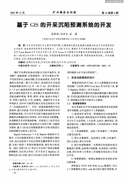
开采沉陷与GIS
- 格式:ppt
- 大小:3.49 MB
- 文档页数:57

基于ArcGIS的矿山开采沉陷区变形规律预计的探讨的开题报告一、研究背景及意义随着现代化的发展,矿山开采规模逐渐扩大,矿山开采对周边自然环境产生的影响也越来越严重。
其中之一便是矿山开采引起的地面沉降和地表位移。
沉降与位移会对周边地区的生态环境、生产生活及民生安全产生重大影响,因此,精确地测量矿山开采沉降区变形规律,预测其变形趋势,及时采取措施减轻沉降和地表位移发生的风险,已经成为工程领域不可回避的问题。
随着GIS技术的不断发展和全球定位系统和遥感技术的进步,矿山开采沉陷区变形规律预计的技术水平也不断提高,如何将这些技术应用于实际工程测量中,成为了当前亟待解决的问题。
因此,本文将从基于ArcGIS的矿山开采沉陷区变形规律预计方法探讨的角度出发,来提出切实可行的技术方案。
二、研究内容及方法1.基于ArcGIS的矿山开采沉陷区变形规律预计方法的研究。
该研究主要针对ArcGIS软件在矿山开采沉陷区变形规律预计方面的应用,结合遥感技术和全球定位系统,实现对矿山区域内的地面沉降和地表位移情况的三维测量和数据分析。
2.研究开采沉陷区的变形规律。
通过对矿山区域内的地面沉降和地表位移情况进行时空分析,基于GIS技术,结合统计方法和数据挖掘技术,分析矿山开采沉陷区变形规律,深入理解矿山开采对周边自然环境的影响。
3.研究矿山防护方法。
基于矿山开采沉陷区变形规律预计,探索出一些矿山防护方法,如在矿山开采前加强地面支撑、采用定向爆破技术、开展控制性采矿等,从而降低矿山开采对周边生态环境的影响,保护民生安全。
三、研究计划及预期结果研究期限:2018年7月1日至2019年6月30日。
1.前期调查研究(2018年7月1日-2018年9月30日)主要任务:收集与研究领域有关的文献、资料,研究国内外矿山开采沉陷区变形规律预计的相关技术,了解现状。
2.设计方案及实施(2018年10月1日-2019年2月28日)主要任务:根据前期调查的结果,设计本项目的研究方案和实施计划,采购实验所需设备器材,开展实验研究和数据处理工作。

基于GIS的开采沉陷预计与区域滑坡危险性预测的开题报告一、研究背景和意义随着经济的快速发展,资源开采等人类活动日益增多,其对环境的影响也越来越显著,其中地面沉降和滑坡等问题日益凸显。
近年来,我国地质灾害频繁发生,造成了人员伤亡和财产损失,给社会带来了沉重的负担。
因此,针对这些问题进行研究和预测具有重要意义。
地理信息系统(GIS)以其强大的数据处理和空间分析能力,成为地质灾害研究和预测的重要工具。
GIS在资源开采、城市规划、生态环境保护等领域中的应用日渐广泛。
利用GIS技术,可以对地质灾害的区域分布、空间特征、影响因素等进行综合分析,有助于提高预测准确性和预警灵敏度。
二、研究内容本研究主要针对开采沉陷和区域滑坡两个问题,在GIS平台下进行预测和分析。
具体研究内容如下:1. 开采沉陷预计开采沉陷是指在采矿、注水压裂等过程中,地下水、矿物层等的减压和移动导致地表的下沉和变形。
本研究将利用GIS平台,结合卫星遥感和地面监测数据,对开采沉陷的形成机理、影响因素以及预测方法进行研究。
通过GIS技术,构建开采沉陷的空间数据库,分析不同开采方式、地质条件、水文条件等对沉降的影响,并建立基于GIS的开采沉陷预测模型。
2. 区域滑坡危险性预测区域滑坡是指在自然因素或人类活动的影响下,山体或土坡等发生的大面积滑坡。
本研究将利用GIS平台,结合多源数据和地质灾害历史记录,对区域滑坡的分布、特征、危险性进行预测和分析。
通过空间插值、缓冲区分析等GIS技术手段,构建区域滑坡的空间数据库,分析地形、地质、水文等因素对滑坡的影响,并建立基于GIS的区域滑坡危险性预测模型。
三、研究方法本研究将利用GIS技术,以开采沉陷和区域滑坡为重点,进行以下研究方法的应用:1. 数据采集和处理利用卫星遥感、正射影像、地面监测等多源数据,建立开采沉陷和区域滑坡的数据库,对数据进行处理和分析。
2. 空间分析和模型建立通过GIS平台进行空间分析,包括缓冲区分析、空间插值、属性查询等,探究开采沉陷和区域滑坡的分布特征和影响因素,并建立基于GIS 的预测模型。

翻译部分英文原文Sensitivity analysis for the GIS-based mapping of the groundsubsidence hazard near abandoned underground coal mines Abstract Ground subsidence around abandoned under-ground coal mines can cause much loss of life and prop-erty. We analyze factors that can affect ground subsidence around abandoned mines in Jeongahm in Kangwon-do by sensitivity analysis in geographic information system (GIS).Spatial data for the subsidence area, topography and geology and various ground engineering data were col-lected and used to make a factor raster database for a ground subsidence hazard map. To determine the impor-tance of extracted subsidence-related factors, frequency ratio model and sensitivity analysis were employed. Sen-sitivity analysis is a method for comparing the combined effects of all factors except one. Sensitivity analysis and its verification showed that using all factors provided 91.61% accuracy. The best accuracy was achieved by not consid-ering the groundwater depth (92.77%) and the worst by not considering the lineament (85.42%). The results show that the distance from the lineament and the distance from the drift highly affected the occurrence of ground subsidence, and the groundwater depth, land use and rock mass rating had the least effects. Thus, we determined causes of ground subsidence in the study area and this information could help in the prediction of ground subsidence in other areas.Keywords GIS Abandoned underground coal mine Ground subsidence Frequency ratio Sensitivity analysis KoreaIntroductionCoal industry has played a major role in the development of the Korean economy since the 1960s. However, the coal industry began to decline from the end of the 1980s because the oil price fell globally. There were 173 coal mines in 1988 in Jeongseon, Kangwon-do, the largest coal mining region in Korea. However, valueless coal mines were abandoned after the implementation of coal industry rationalization action by Korean government. Today, no coal mines are in operation. In the abandoned coal mines in Jeongseon, environmental pollution, having never been considered a future problem at the time the mines ceased operating, is on the increase. Heavy metals in wastewater from coal mines and muck reaching rivers and soil is a serious problem. In particular, most abandoned coal mines are in mountain ranges and their damage to the environ-ment is not widely known. Ground subsidence due to anunderground coal mine is a hazard to human life as well as to property such as railways, roads, houses and buildings. In addition, it is difficult to completely recover an area of subsidence and rehabilitation is expensive. Moreover, most countermeasures for ground subsidence are simply rein-forcements after ground subsidence has already occurred. Therefore, it is necessary to have a systematic prediction and management plan for an area of ground subsidence.There have been many studies on the prediction of ground subsidence locations and how to decrease related damage.MethodologyIn general, to predict ground subsidence it is necessary to assume that subsidence occurrence is determined by sub-sidence-related factors, and that future subsidence will occur under conditions that are the same as those for past subsidence according to the relative frequency concept of probability theory. On this basis, the relationship between areas where subsidence has occurred and subsidence-rela-ted factors can be distinguished from the relationship between areas without past subsidence and subsidence-related factors. In this work, the spatial relationships between subsidence locations and each subsidence-related factor were analyzed using the frequency ratio which is one of the probability models. The frequency ratio is the ratio of the area where subsidence has occurred to the total study area, and is also the ratio of the probability of subsidence occurrence to no occurrence for a given attribute. In the case of subsidence occurrence, if the subsidence event is de notedB and a given factor’s attribute is denoted D, then the frequency ratio of D is the ratio of the conditional probabilities of B . Therefore, the greater this ratio, the stronger the relationship between subsidence occurrence and the given factor’s att ribute. The frequency ratio was calculated for each factor type or range that had been identified as significant with respect to causing ground subsidence. The ratios were used for calculating the ground subsidence hazard index (GSHI) and mapping. There have been a few studies carried out on ground subsidence hazard evaluations using the frequency ratio and a GIS; for example, Kim et al. ( 2006) introduced the analysis of ground subsidence hazard and summarized many ground subsidence hazard evolution studies.Diagrams presented in Fig.4 show the steps for calcu-lating the frequency ratio: (a) finding locations of groundsubsidence, (b) representing cells of class 1 for factor A and (c) describing the area of spatial overlap for areas of subsidence and areas of class 1 for factor A. In the presentexample in which the study area comprises 64 cells, there are 23 ground subsidence cells and 19 cells that are of class 1 for factor A. There are 12 cells of subsidence that are also cells of class 1 for factor A. The percentages for subsidence area with respect to class 1 for factor A and the entire domain are 52.17 and 29.69%,respectively. Therefore, the frequency ratio of class 1 for factor A is 52.17/29.69% = 1.76.Sensitivity analysisSensitivity analyses show how a solution changes when the input factors are changed. If the selection of a factor results in a relatively large change in the outcome, then the out-come is said to depend on that factor. Sensitivity analysis quantifies the uncertainty of each factor. The factors that have the greatest impact on the calculated subsidence hazard map can therefore be identified.Sensitivity analyses model behavior by determining the rate of change in the model output as parameters or input data are varied, thus giving an understanding of how changes in the inputs influence the output. Such analyses explain how inputs affect the output and quantify the strengths of the inputs from the variations in the output. Sensitivity analysis has been applied in a variety of studies. Arhonditsis and Brett (2005) introduced process formula-tions and sensitivity analysis for a complex eutrophication model of Lake Washington, USA. Joo et al. ( 1998) repre-sented the sensitivity of the leachate level to reduce the high leachate level in landfill. Sensitivity analysis has been applied to landslide susceptibility hazard mapping (Lee and Talib2005). In the present study, the sensitivity analyses were conducted to determine factors involved in ground subsidence. To extract subsidence-related factors, the fre-quency ratio model and sensitivity analysis were employed. The sensitivity analysis compared the effects of all factors except one.DataMany studies have identified important factors that con-tribute to ground subsidence around coal mines (e.g.Waltham 1989; Coal Industry Promotion Board 1997), including the depth and height of mine cavities, excavation method, degree of inclination of the excavation, scope of mining, structural geology, flow of groundwater and the mechanical characteristics represented by the rock mass rating (RMR).In this study, locations of ground subsidence and factors governing the occurrence of ground subsidence were col-lected in a vector-type spatial database and then repre-sented on a grid using the ArcGIS software package. The spatial database is shown in Table 1 . The database included a 1:5,000 ground subsidence map, 1:50,000 geological map, 1:5,000 topographic map, 1:5,000 land use map, 1:1,200 mine tunnel map, borehole data and satellite imagery with 1 m resolution. The site Jeongahm was chosen for investigation in this study. Reliable accuracy of the spatial database is indispensable in a GIS environment. For this reason, accurate maps authorized by national organizations such as the Coal Industry Promotion Board for ground subsidence, the National Geographic Informa-tion Institute for topography andland use, the Mine Rec-lamation Corp. for mine tunnels and boreholes and the Korea Institute of Geoscience and Mineral Resources for geology were assembled even though the scales of the maps differed.Eight variables as shown in Fig. 5 , extracted from the constructed spatial database, were considered as factors of ground subsidence when calculating the probability. Con-tours (5 m intervals) and survey base points of elevation were extracted from the topographic map, and triangu-lated irregular network was made using the elevations. The angle of slope was obtained from the digital elevation map. Areas of buildings, mountains, railways, fields, rivers, hybrids, roads and miscellaneous use were extracted from the land use map. Most literature states that the major factor in ground subsidence is the scope of mine cavities. Therefore, constructing a database for the depths and widths of mine cavities was important. To achieve this, (1) GPS measurements were used to determine the exact positions of mine heads, (2) these positions were used to vectorize a hard copy of the mine tunnel map and (3) the vectorized mine tunnel map was converted to an ASCII grid file and subtracted from the digital elevation map raster data. There were 13 boreholes at the study site, but four boreholes did not have RMR values and groundwater levels. An inverse-distance weighting interpolation was used to contour the RMR and groundwater level. Geolog-ical data were extracted from the 1:50,000 geological map.A lineament was detected from IKONOS imagery with 1-m resolution by a structural geologist. The distance from the lineament was calculated at 1-m intervals using the Euclidean distance method. The factors were then repre-sented by 2 m 9 2 m cells in 179 rows and 361 columns; the entire study area comprised 63,677 cells, and ground subsidence had occurred in 824 cells.All of scale factors except geology and land use were reclassified into ten classes based on equal area using ArcGIS 9.0 for the probability analysis of the area of existing ground subsidence. Each class has a similar number of cells in total area (Table 2 ). Thus, the range of each class is automatically determined based on equal area. Reclassification is a generalization technique used to re-assign values such as ratio from frequency ratio model, in an input theme to create a new input theme. Thus, this technique is commonly used to convert re-assign values into an ordinal ranking for subsidence hazard modeling using map algebra, help to be displayed in easy-to-under-stand hazard maps.ResultsCalculation of the frequency ratio and its interpretationUsing the frequency ratio model, the frequency ratio of each factor in each class range was calculated (Table 2 ). From the frequency ratio, the relationships between sub-sidence and the factors were as follows: The ratio for slopes of14.70–19.89was greater than 1, indicating a high probability, but that for slopes over 29 was less than 1.0, indicating a low probability. If ground subsidence occurred for steep slopes, it would not be noted owing to the difficulty in accessing such areas during fieldwork. In this case, land surface subsidence needs to be monitored by differential synthetic aperture radar interferometry. Drift at depths up to 69.35 m had ratios greater than 4.0, indicating a very high probability. Deeper mining tunnels had ratios less than 4.0. In the case of distance from the drift, the ratio was greater than 1 from 0 to 8.59 m but less than 1 over 8.59 m. Groundwater at depths from 11.38 to 13.21 had a ratio greater than 1, indicating a very high probability. The ratio for an RMR from 2.466 to 2.479 was greater than 2, indicating a very high probability. The subsidence proba-bility decreased with distance from the lineament, with the ratio being 3.92 at 0–4.29 m from the lineament. In the case of geology, Sadong group had a ratio of 1.64, indi-cating a high probability of subsidence. In the case of land use, areas of buildings and fields had ratios of 2.3 and 2.03, respectively, indicating a very high probabilityTable 1 Relationship between ground subsidence and related factor using中文译文以GIS为基础的煤矿开采沉陷危机分析摘要煤矿开采导致周围地面的沉陷会导致很多人的死亡以及各种不幸。

GIS结合MSPS在煤矿开采沉陷预计中的应用本文在煤矿开采沉陷预计工作中引入GIS技术以及MSPS技术,就其实施要点进行了分析与研究,希望能够引起各方关注与重视。
标签:GIS MSPS 煤矿开采沉陷预计某煤矿开采工作面以10煤层为主要开采对象,开采深度在465.0m左右。
1#工作面回采长度为650.0m,倾向宽度为180.0m,采厚为4.2m;2#工作面回采长度为710.0m,倾向宽度为180.0m,采厚为3.6m。
本开采区域内所对应的设计生产能力为60.0×10⁴t/a。
结合该实际案例,本文展开对煤矿开采沉陷预计相关问题的分析工作。
1 预计参数对于特定开采作业而言,预计参数为常数项,而对于不同开采作业而言,预计参数则表现为变量。
可作用于预测作业的方法众多,应当结合开采区域的特殊地质条件以及预计要求进行选择使用。
对于本文所研究的MSPS系统而言,预测方法为概率积分法。
本方法下,所涉及到的评估指标包括以下多个方面:一是下沉系数,二是水平移动系数,三是主要影响角正切系数,四是拐点偏距系数。
在本工程中,初次采动所对应的采动系数以及重复采动所对应的采动系数取值均等,参照现行标准中矿区地表形态变化实测参数,根据地表沉陷系数取值,设置为1:1,同时,对应的主要影响角正切系数取值为1.7,水平移动系数取值为0.3,拐点偏距参数取值为0。
2 开采沉陷预计分析在MSPS系统干预下,对于煤矿开采沉陷的预计可以根据矿区的回采阶段以及采区的不同加以灵活的设置。
结合本工程具体情况来看,所对应的工作面沉陷预计下沉等值线示意图如下图所示(见图1)。
结合图1来看,认为在采空区开采尺寸持续扩大并达到一定范围的情况下,开采作业的实施会对地表产生一定的影响,主要表现为变形或移动。
随着时间的推移,地表可能形成面积高于采空区的下沉盆地。
更加关键的一点在于:在地表下沉稳定的过程当中,采空区中央可检出最大下沉值。
同时,由于GIS空间模型具有良好的可视化、美观性、以及直观性优势,能够支持对包括采掘工程平面图、煤层底板等值线图、以及井上下行对照图等基础资料的收集整理,将在CAD软件环境下的图形转换为可供GIS所识别的环境图形。


大红山矿区开采沉陷预计的MapGIS方法刘德元;孙新华;何盛东;张卓然【期刊名称】《金属矿山》【年(卷),期】2016(000)009【摘要】为有效预计矿山开采过程中地表产生的沉陷变形,以大红山铁矿为例,在现场工程地质勘查和变形监测数据收集的基础上,首先根据矿区钻孔数据(钻孔深度、孔口高程、地下水位深度、地层岩性、地层结构及厚度以及地层时代)建立了基础地质数据库;其次分别对地形坡度、地质构造、岩性条件、植被覆盖率、降雨等级、开采面积及深度等开采沉陷影响因素进行了权重赋值;然后根据水平、垂直、曲率变形值,将该矿区地表建筑物受损等级划分为4级,并对各危险等级的处理方法进行了分析;最后基于矿区基础地质数据,采用MapGIS软件构建了矿区开采沉陷预计模型,并对矿区开采沉陷危险性区域进行了划分。
研究结果表明:①开采面积及深度的权重值为0.45,可见矿山开采沉陷受该因素的影响最大;②2#矿体地表最大沉降值为431.1 mm,最大水平移动值为125 mm,最大倾斜值为4.95 mm,预计结果与实测值基本吻合;③2#矿体对应的地表沉陷危险等级为Ⅳ级,区内建筑物可能发生结构损坏,需及时采取防范措施。
【总页数】4页(P157-160)【作者】刘德元;孙新华;何盛东;张卓然【作者单位】河南省煤田地质局资源环境调查中心,河南郑州450003;河南省煤田地质局资源环境调查中心,河南郑州450003;郑州航空航天工业管理学院土木建筑工程学院,河南郑州450046;河南省煤田地质局物探测量队,河南郑州540009【正文语种】中文【中图分类】TD325【相关文献】1.江西盘古山钨矿区开采沉陷预计的GA-SVA算法 [J], 陈慧;韩恒梅2.开采沉陷预计数据自动嵌入矿区DEM的方法研究 [J], 韩奎峰3.基于InSAR技术和GS-SVR算法的r矿区地表开采沉陷预计 [J], 马飞;隋立春;姚顽强;汤伏全4.矿区开采沉陷预计方法与治理对策研究 [J], 朱明非;陈小轶;秦礼明5.矿区开采沉陷预计方法与治理对策研究 [J], 朱明非;陈小轶;秦礼明;因版权原因,仅展示原文概要,查看原文内容请购买。


基于ArcGIS Engine的矿区开采沉陷预测系统开发摘要:本文主要讨论了矿区开采沉陷预测系统的预测模型、程序设计和实现方法,探讨了关于利用ArcGIS Engine技术在矿区开采沉陷预测方面的应用,及可视化表达的方法。
关键词ArcGIS Engine 开采沉陷概率积分法1 引言煤矿地表开采沉陷一直是危害矿区生产和居民生命财产安全的主要地质灾害之一,如何有效的预测和防治矿区开采沉陷灾害一直是矿区开采研究的主要内容。
开采沉陷是一个复杂的地质活动,地表沉陷情况受开采深度、采煤厚度、上覆岩层情况、煤层倾角、顶板管理方法等一系列因素的影响,预测模型涉及的参数较多,中间产生的图形图件也比较多,对空间数据的管理和可视化表达有较高的要求。
地理信息系统是20世纪60年代以来迅速发展起来的一门空间科学技术,具有良好的空间数据存储和表达能力。
将GIS技术有效的应用于矿区开采沉陷研究中,对矿区开采沉陷预测和表达能起到良好的效果。
其中,ArcGIS是GIS技术中比较优秀的软件之一,基于ArcGIS Engine平台的二次开发能够很好的满足矿区开采沉陷预测过程中所涉及的模型计算和空间表达等要求。
2 系统设计与实现系统采用Visual Stadio 2010作为开发平台,C#作为软件开发语言,使用ArcGIS Engine工具进行二次开发。
软件根据实际生产中对煤矿开采工作面地表开采沉陷情况的具体处理过程,进行程序设计和编写。
系统的主流程图如图2.1所示。
2.1 应用模型矿区地表开采沉降预测的方法有很多,目前常用的模型有概率积分法、负指数函数法、典型曲线法、积分网格法等。
其中,概率积分法使用最为广泛,同时方法简单易行,又是从实测资料进行总结,极为符合我国煤矿开采情况,在相似地质采矿条件下有着较好的预测精度,误差较小,所以系统采用概率积分法进行开采沉陷预测。
系统采用的是西安科技大学汤伏全教授的厚松散层覆盖矿区开采沉陷预测模型进行预测。


XX煤矿开采沉陷预测分析信息系统需求分析报告组员:李华勇(07093303)组员:刘天梁(07093305)班级:土地09-2班日期: 2011年10月10日目录1引言1.1编写目的 (3)1.2项目背景 (3)1.3定义 (3)1.4参考资料 (3)2任务概述2.1目标 (4)2.2运行环境 (4)2.2.1硬件环境 (4)2.2.2软件环境 (5)2.2.3网络环境 (6)2.2.4软件使用人员 (6)3数据需求3.1数据描述 (6)3.2数据库描述 (7)3.3数据采集 (7)4数据流程图5功能需求5.1功能需求概述 (14)5.2功能划分 (14)5.3具体功能需求 (17)6非功能性需求6.1性能需求 (18)6.2需求变化 (18)6.3安全性需求 (18)7用户界面8总结1引言1.1编写目的本文档将综合分析矿区开采引起的地表沉陷的各种条件和数据,同时分析XX矿山企业对该分析系统的需求情况。
总结出XX矿山企业煤矿开采沉陷预测分析系统需求分析报告,为系统建设提供理论依据。
本文档主要是开发人员进行系统设计开发的主要依据,是数据分析、设计和软件系统开发的主要依据之一。
1.2项目背景煤矿开采沉陷对矿区环境造成严重的损害,己成为为制约矿区可持续发展的主要问题之一。
随着计算机软硬件技术的发展,涌现出了许多预测煤矿开采沉陷方面的软件,减小或者完全避免了煤矿地下开采的有害影响;但现有开采沉陷预计模型的分析结果大多数以一维的剖面线、曲线图或等值线图的形式输出,这种表达不能直观全面反映开采沉陷影响的时间性、空间性及和周围环境的关联性;因此需要一套能科学预测煤矿开采沉陷范围,并目能够三维一体地显示出煤矿开采引起地表沉陷规律的软件系统,可以对煤矿开采沉陷对地表构筑物及土地的危害程度等做出准确的分析,这套软件系统针对这一需求,可以辅助矿区进行开采沉陷预测,以指导矿山企业的可持续发展。
1.3定义下面是在文档中的常用缩写语与术语的定义与解释。


Gis在矿区开采沉陷中的应用研究摘要:随着科学技术的不断发展,gis技术作为当代地球科学发展的新技术已经显示出了广阔的应用前景。
尤其是近些年来随着人们对gis技术认识的加深,发展矿区地理信息系统的技术路线已经深入人心。
矿区作为一个复杂的地理系统,由于其地貌、矿体、围岩、构造及地压等的变化加上矿山开采活动的影响,为了最大程度的减少开采造成的损失,对破坏影响进行预测、评估,本文将从一些技术方面阐述gis在开采沉陷中的应用。
关键词:gis 开采沉陷应用研究1. gis概述地理信息系统(gis)是20世纪60年代发展起来的一门集科学、信息学、地理学等多门学科为一体的新兴科学。
地理信息系统是以地理空间数据库为基础,在计算机软硬件的支持下,运用系统工程和信息科学的理论,科学的管理和综合分析具有空间内涵的地理数据,以提供管理、决策等所需信息的技术系统。
简单的说,GIS是综合处理和分析地理空间数据的一种技术系统,它是以测绘测量为基础,以数据库作为数据储存和使用的数据源,并以计算机编程为平台的全球空间分析即时技术。
地理信息系统主要由四部分构成,包括:硬件系统、软件系统、地理空间数据和系统开发。
自上世纪80年代末以来gis技术已经广泛应用于城市管理、交通管理、城市规划、抗震防灾、灾害损失监测等各个领域。
我国地理信息系统方面的工作自80年代开始也日渐成熟,逐渐走向产业化。
gis技术的优势:1. 所获得的数据通过gis的空间分析功能,能够及时发现环境的变化,分析矿区开采对其周边地区环境的影响程度和损坏程度。
2. 利用gis技术能够解决传统环境分析方法难以完成的空间模拟问题,例如开采沉陷规律及扩散、开采破坏分析等。
3. gis的数据库功能,能够建立和管理有关的环境数据库并有效地对评价地区的环境评价数据进行属性数据和空间数据的查询、更新和提取。
4. gis可以实现研究结果显示和输出的可视化、图形图像化、专题化和立体化。
例如在矿山地区地表沉陷监测方面的应用等。

基于GIS的矿山地面沉陷分析研究【摘要】:矿产资源的大规模开发和利用,极大地推动了人类经济和社会的发展,在矿山开采过程中,经常会出现地面沉陷的现象,给人们的生活和居住环境造成了很大的影响,为有效地控制和减轻沉陷程度,减少不必要的影响,减轻或避免环境灾害,有必要对矿山地面沉陷进行分析,对矿山开采引起的地面沉陷造成的损失进行预测评估,提出了具体可行的治理对策。
【关键词】:gis;矿山地面沉陷;分析研究中图分类号:td167文献标识码: a 文章编号:引言随着经济的快速发展,gis技术日益成熟,其应用范围越来越广泛,特别是在大地测量、工程测量、地壳形变测量等多个领域内,gis技术起着至关重要的作用。
近些年来,矿山在开采的过程中,其采空区沉陷现象较为普遍,影响矿山开采的正常进行,鉴于此状,各个企业开始着手于这一方便的研究,目前已经形成一定的检测方法。
一、我国开采现状地下矿产资源的开发开采在给我们带来巨大社会经济价值的同时,也对土地资源及建筑物、构筑物造成破坏,影响到整个环境系统,留下塌陷的采空区和荒芜的采矿场。
我国是产煤大国,每年因煤炭开采造成的塌陷土地有2.4万公顷,平均每采1万吨煤炭就有0.2km2土地坍塌,至1990年底,我国已有30万公顷土地因煤炭开采而坍塌,然而这个数据竟在近20年内被翻了一番。
土地沉陷不仅影响整个环境系统,也影响到人们正常的生产生活,还会对人类的生命安全造成一定的损害。
因此,必须采用新思路、新方法,提高地表沉降预测的准确性,控制地表沉陷引起的破坏,为社会的和谐发展提供技术支撑。
二、矿山开采沉陷带来的环境灾害问题1、矿山开采过程中出现沉陷的原因人为活动是导致在矿山开采出现沉陷的主要原因,特别是进行地下采掘活动时,矿山容易出现采空区,在开采过程中上方岩、土体也就没有良好的支撑,最终导致地面塌陷,甚至出现安全事故等严重后果。
我国许多的矿区都有矿山沉陷现象的发生,建筑物、交通设施、水利设施、道路、农田等在很大程度上受到了破坏,甚至引起山体滑坡和崩塌现象,导致安全事故的发生。


