地理信息科学专业英语书后句子
- 格式:doc
- 大小:45.00 KB
- 文档页数:18
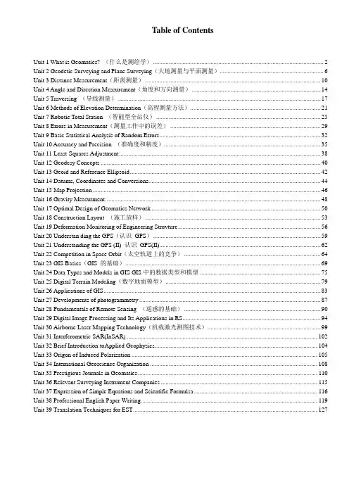
Table of ContentsUuit 1 What is Geomatics? (什么是测绘学) (2)Unit 2 Geodetic Surveying and Plane Surveying(大地测量与平面测量) (6)Unit 3 Distance Measurement(距离测量) (10)Unit 4 Angle and Direction Measurement(角度和方向测量) (14)Unit 5 Traversing (导线测量) (17)Unit 6 Methods of Elevation Determination(高程测量方法) (21)Unit 7 Robotic Total Station (智能型全站仪) (25)Unit 8 Errors in Measurement(测量工作中的误差) (29)Unit 9 Basic Statistical Analysis of Random Errors (32)Unit 10 Accuracy and Precision (准确度和精度) (35)Unit 11 Least-Squares Adjustment (38)Unit 12 Geodesy Concepts (40)Unit 13 Geoid and Reference Ellipsoid (42)Unit 14 Datums, Coordinates and Conversions (44)Unit 15 Map Projection (46)Unit 16 Gravity Measurment (48)Unit 17 Optimal Design of Geomatics Network (50)Unit 18 Construction Layout (施工放样) (53)Unit 19 Deformation Monitoring of Engineering Struvture (56)Unit 20 Understan ding the GPS(认识GPS) (59)Uuit 21 Understanding the GPS (II) 认识GPS(II) (62)Unit 22 Competition in Space Orbit(太空轨道上的竞争) (64)Unit 23 GIS Basics(GIS 的基础) (69)Unit 24 Data Types and Models in GIS GIS中的数据类型和模型 (75)Unit 25 Digital Terrain Modeling(数字地面模型) (79)Unit 26 Applications of GIS (83)Unit 27 Developments of photogrammetry (87)Unit 28 Fundamentals of Remote Sensing (遥感的基础) (90)Unit 29 Digital Image Processing and Its Applications in RS (94)Unit 30 Airborne Laser Mapping Technology(机载激光测图技术) (99)Unit 31 Interferometric SAR(InSAR) (102)Unit 32 Brief Introduction toApplied Geophysics (104)Unit 33 Origon of Induced Polarization (105)Unit 34 International Geoscience Organization (108)Unit 35 Prestigious Journals in Geomatics (110)Unit 36 Relevant Surveying Instrument Companies (115)Unit 37 Expression of Simple Equations and Scientific Formulsa (116)Unit 38 Professional English Paper Writing (119)Unit 39 Translation Techniques for EST (127)Uuit 1 What is Geomatics? (什么是测绘学)Geomatics Defined(测绘学定义)Where does the word Geomatics come from?(Geomatics-测绘或地球空间信息学,这个名词是怎么来的呢?)GEODESY+GEOINFORMATICS=GEOMA TICS or GEO- for earth and –MATICS for mathematical or GEO- for Geoscience and -MATICS for informatics. (大地测量学+地理信息学=GEOMATICS 测绘学或者geo 代表地球,matics 代表数学,或者geo 代表地球科学,matics 代表信息学)It has been said that geomatics is many things to many people.(据说测绘学这个词对不同的人有不同的理解)The term geomatics emerged first in Canada and as an academic discipline; it has been introduced worldwide in a number of institutes of higher education during the past few years, mostly by renaming what was previously called “geodesy” or “surveying”, and by adding a number of computer scienceand/or GIS-oriented courses.(这个术语【term 术语】作为一个学科【academic discipline 学科】第一次形成【emerge】于加拿大;在过去的几年里被全世界的许多高等教育研究机构所熟知,通常是以前的“大地测量学” 或“测量学”在引入了许多计算机科学和GIS 方向【或“基于GIS” 】的课程后重新命名的。
一,1 these “hauling ways” initially had a surface of stone slabs or timber baulks,shich soon proved unsatisfactory as the loads carried inevitably grew heavier.这种拖拉方式起初依靠石板或木梁的平面进行,但随着载重的不断增大,证明这种方式是不可行的。
2within that definition there is a host of variations in forms of propulsion,details of track structure,train make-up or “consist”,dominant class of traffic and so on which fall within the meaning of the term “railway”.在该定义下,有许多不同形式,如驱动方式、轨道结构、列车组成、交通管辖等都落在地铁这个术语的范畴内3the “trackbed” comprises the ballast and any subballast layers and is there to support the track,to drain water from the bottom of the sleepers and to distribute the imposed track load to such s degree that the subgrade can resist the imposed bearing pressure adequately.道床由道砟和所有底层道砟组成,从而支撑轨道,从轨枕底排水,并且分散施加在轨道上的载荷,以致路基足以承受的压力程度4 combining the vehicles into trains is important in increasing the capacity of a narrow transportation corridor, particularlary important in providing needed mobility without wasting vast areas of real estate.将车辆连接组成列车,对增大这种狭长通道交通方式的运用能力至关重要,特别是提供了必需的资产流动以避免造成大量不动资产的浪费。
《专业英语》课程教学大纲课程名称(中文/英文):专业英语/ Professional English 课程编码:12024019 课程类型:专业选修课 课程性质:专业课 适用范围:06地理信息系统学分数:2 先修课程:《大学英语》《地理信息系统》 学时数:36 其中:实验/实践学时:0 课外学时:0 考核方式:考查 制订日期:2006年制订单位:广州大学地理科学学院 审核者:夏丽华 执笔者:冯艳芬一、教学大纲说明(一)课程的地位、作用和任务(一)课程的地位、作用和任务该课程属于地理信息系统专业基础课之一,通过该课程的学习,学生基本能掌握常用的地理信息系统专业词汇,能查阅相关的外文资料,阅读简单的外文文献,阅读简单的外文文献,能进行简单的英文能进行简单的英文摘要撰写。
摘要撰写。
本课程的任务主要为:本课程的任务主要为:(1) 增加学生专业词汇量增加学生专业词汇量 (2) 介绍专业文献阅读的技巧介绍专业文献阅读的技巧 (3) 加强对英文长句翻译的训练加强对英文长句翻译的训练 (4) 介绍论文英文摘要的写法介绍论文英文摘要的写法(5) 介绍专业在国际上的发展趋势介绍专业在国际上的发展趋势 (二)课程教学的目的和要求(二)课程教学的目的和要求能让学生在学完二年能让学生在学完二年《大学英语》的基础上,《大学英语》的基础上,《大学英语》的基础上,增加专业方面的词汇,同时了解本专业在增加专业方面的词汇,同时了解本专业在英文上的表达方式,通过本课程的学习,通过本课程的学习,学生能掌握较多的专业词汇,学生能掌握较多的专业词汇,学生能掌握较多的专业词汇,能根据教学的要求查能根据教学的要求查阅简单的外文专业文献,基本能够读懂文献中的主要方法与主要内容,同时能为四年级论文的撰写打下基础,介绍论文英文摘要的写法。
的撰写打下基础,介绍论文英文摘要的写法。
要求:掌握要求:掌握500个专业词汇,个专业词汇,能基本完成对专能基本完成对专业长句中译英或英译中的翻译,基本能读懂专业文献。

Unit 1What Is Geomatics?Geomatics DefinedWhere does the word Geomatics come from? GEODESY + GEOINFORMATICS =GEOMATICS or GEO-for earth and -MATICS for mathematical or GEO-for Geoscience and -MATICS for informatics.It has been said that geomatics is many things to many people. The term geomatics emerged first in Canada and as an academic discipline; it has been introduced worldwide in a number of institutes of higher education during the past few years, mostly by renaming what was previously called " geodesy"or"surveying", and by adding a number of computer science--and/ or GIS-oriented courses. Now the term includes the traditional surveying definition along with surveying steadily increased importance with the development of new technologies and the growing demand for a variety of spatially related types of information, particularly in measuring and monitoring our environment. Increasingly critical are areas of expanding populations, appreciating land values, dwindling natural resources, and the continuing stressing of the quality of our land, water and air from human activities. As such, geomatics bridges wide arcs from the geosciences through various engineering sciences and computer sciences to spatial planning, land development and the environmental sciences. Now the word geomatics has been adopted by several international bodies including the International Standards Organization (ISO), so it is here to stay.The term "surveyor" is traditionally used to collectively describe those engaged in the above activities. More explicit job descriptions such as Land Surveyor, Engineering Surveyor or Hydrographic Surveyor for example, are commonly used by practitioners to more clearly describe and market their specialized expertise.The term geomatics is a recent creation to convey the true collective and scientific nature of these related activities and has the flexibility to allow for the incorporation of future technological developments in these fields. Adoption of the term also allows a coherent marketing of the profession to industry and schools on a worldwide basis."As a result,both course and award titles in the traditional Land Surveying sector at many of the world's leading universities are being changed to. "Degree in Geomatics". This does not suggest the demise of the term " surveyor" and graduates will still practice as land surveyors or photogrammetrists,etc. as appropriate to their specialization.In the last decade, there has been dramatic development and growth in the use of hardware and software solutions to both measure and process geo-spatial data. This has created and will continue to create new areas of application, with associated job opportunities for suitably qualified graduates. As a result, the role of the " surveyor" is expanding beyond traditional areas of practice, as described above, into new areas of opportunity. In addition, recent advances in the technology of data collection and processing have blurred the boundaries of practice and activity between what were previously regarded as related but separate areas. Such developments are forecast to continue and will create new career paths for graduates whose education and training is broadly based and of a high academic standard.To enable graduates to take full advantage of these developments, significant changes in education and training are required. Academic and professional oinstitutions are also responding, in part, by adopting the term geomatics both as a course and as an award title. A working definition of geomatics, which reflects current thinking and predicted change, is:The science and technology of acquiring, storing, processing, managing ,canalyzing and presenting geographically referenced information (geo-spatial data).This broad term applies both to science and technology, and integrates the following more specific disciplines and technologies including surveyingand oimapping, geodesy,m satellite o positioning,photogrammetry, remote sensing, geographic information systems (GIS) , land management, computer systems, environmental visualization and computer graphics.Several terms such as "geomatics,""geomatic engineering," and"geoinformatics" are now in common use pertaining to activities generally concerned with geographic information. These terms have been adopted primarily to represent the general approach that geographic information is collected, managed,and applied. Along with land surveying,photogammetry,remote sensing,and cartography,GIS is an important component of geomatics.Branches of GeomaticsData acquisition techniques include field surveying, global positioning system (GPS)satellite positioning, and remotely sensed imagery obtained through aerial photography and satellite imagery. It also includes the acquisition of database material scanned from older maps and plans and data collected by related agencies.Data management and process are handled through the use of computer programs for engineering design, digital photogrammetry,image analysis, relational data base management, and geographic information systems (GIS). Data plotting ( presentation)is handled through the use of mapping and other illustrative computer programs; the presentations are displayed on computer screens ( where interactive editing can occur) and are output on paper from digital plotting devices.Once the positions and attributes of geographic entities have been digitized and stored in computer memory,they are available for use by a wide variety of users. Through the use of modem information technology (IT), geomatics brings together professionals in the following disciplines: surveying, mapping, remote sensing, land registration, civil and marine engineering, forestry,agriculture, planning and development, geology,geographical sciences,infrastructure management, navigation, environmental and natural resources monitoring, and computer science.Other Definitions of GeomaticsAs defined by the Canadian Institute of Geomatics in their quarterly journal Geomatica:Geomatics is a field of activities which, using a systemic approach, integrates all the means used to acquire and manage spatial data required as part of scientific,administrative, legal and technical operations involved in the process of the production and management of spatial information.The definition of Geomatics is evolving. A working definition might be "the art, science and technologies related to the management of geographically-referenced information.Geomatics includes a wide range of activities, from the acquisition and analysis of site specific spatial data in engineering and development surveys to the application of GIS and remote sensing technologies in environmental management. It includes cadastral surveying, hydrographic surveying, and ocean mapping, and it plays an important role in land administration and land use management.Geomatics is the modern scientific term referring to the integrated approach of measurement, analysis, management, storage and display of the descriptions and location of Earth-based data, often termed spatial data. These data come from many sources, including earth orbiting satellites, air and sea-borne sensors and ground based instruments. It is processed and manipulated with state-of-the-art information technology using computer software and hardware. It has applications in all disciplines which depend on spatial data, including environmental studies,planning, engineering,navigation,geology (and geophysics, oceanography, land development and land ownership and tourism. It is thus fundamental to all the geoscience disciplines which use spatially related data.[ from the School of Geomatic Engineering, Univ. of New South Wales]Geomatics is concerned with the measurement, representation, analysis,management,retrieval and display of spatial data concerning both the Earths physical features and the built environment. The principal disciplines embraced by Geomatics include the mapping sciences, land management, geographic information systems,i1environmental visualisation, geodesy, photogrammetry, remote sensing and surveying.[ from the Dept. of Geomatics at Univ. of Melbourne]Geomatics comprises the science, engineering, and art involved in collecting andmanaging geographically-referenced information. Geographical information plays animportant role in activities such as environmental monitoring, management of land andmarine resources, and real estate transactions.[ from the Dept. of Geodesy and Geomatics Engineering at UNB]The science of Geomatics is concerned with the measurement, representation , analysis management, retrieval and display of spatial information describing both the Earth'g physical features and the built environment. Geomatics includes disciplines such as:Surveying, Geodesy,Remote Sensing & Photogrammetry, Cartography, Geographic Information Systems, Global Positioning Systems.[ from the Dept. of Surveying and Spatial Information Science at the Univ. of Tasmania]□ Notes:①测绘学(Geomatics)这个术语最初作为一门学科专业出现于加拿大,在过去几年里已被世界各地众多的高等教育机构所采纳,大多数是由以前的“大地测量学”或“测量学”并引入许多计算机科学和地理信息系统方向的课程后重新命名的。
(完整word)测绘专业英语单词Chapter 1Geomatics 测绘学Surveying 测量学Geodesy 测地学Geosciences 地球科学Surveying and mapping 测绘学Surveying and mapping engineering 测绘工程Geoinformatics 地理信息学Geodetic network 大地控制网Land Surveyor 土地测量员Photogrammetriest 摄影测量员Practitioner 从业者Topographic map 地形图Geographic information system 地理信息系统Aerial photogrammetry 航空摄影测量学Remote sensing 遥感Cartography 地图制图学Computer graphics 计算机图形学Global navigation satellite system GNSSGlobal position system GPS Environmental visualization 环境可视化Geographic information system GIS Geographic referenced information 地理参考信息Landforms 地形Underground geological structure 地下地质构造Hydrology 水文学Mineral resources 矿产资源Topographic maps 地形图Geodynamic phenomena 地球动力学现象Polar motion 极移Crustal motion 地壳运动Earth tides 地球潮汐Sphere 球(体)Spheroid 球体Ellipse 椭圆Ellipsoid 椭圆体,椭球Surveying station 测站Geodetic control points 大地控制点With permanent monuments 永久标志Curved surface 曲面Straight line 直线Plane 平面Precise instrument 精密仪器Reference coordinat e 参考坐标Contour maps 等值线图Three dimensional model 三维模型Analog or digital forms 模拟或数字形式Specialized illustration software 专业插图软件Data acquisition 数据获取Data representation 数据表达Manipulate 处理,操作Data storage 数据存储Data preprocessing 数据预处理Longitude latitude altitude 经度、纬度、高度Regional navigation system 地区导航系统Analog photogrammetry 模拟摄影测量Analytical photogrammetry 解析摄影测量Digital photogrammetry 数字摄影测量Plotter 绘图机Passive remote sensing/active remote sensingFilm photography 胶片Infrared sensors 红外感应Charge coupled devices 电荷耦合器件Radiometer 辐射计Backscattered 反向散射Passive/active sensor/reflector 被动/主动传感器/反射器Henan polytechnic university Geographic data 地理数据Reference spheroid 参考椭球体Curved surface 曲面Analogy form 模拟模式Radio signal 无线信号Laser 激光(完整word)测绘专业英语单词Chapter 2Analog forms 模拟形式Paper plan 平面图Report table 报告表Three dimensional mathematical model 三维数学模型Horizontal and vertical distances 水平距离和垂直距离Determining Elevations 确定高程Direction 方向Location 位置Volume 体积(量)Portray graphically生动描绘Profile/cross section 侧面/横断面Longitudinal section 纵剖面Diagram 图表/示意图Optical theodolite 光学经纬仪Digital level 数字水准仪Electronic Distance Measurement (EDM)Total station 全站仪Aerial photogrammetry 航空摄影Satellite observation 卫星观测Inertial surveying 惯性测量Laser ranging techniques 激光测距技术Large volume of data 大量数据Rigorous processing 严密加工工艺Field/office work 野外/室内工作Conventional construction engineering projects 传统建设工程项目Property surveying 权属调查Geology 地质学 geophysics地球物理biology生物 agriculture 农业forestry 林业 hydrology 水文oceanography 海洋学Geography地理学Distance measurement 距离测量Linear 线性物 non-Spherical earth 球面地Slant 倾斜Tape 卷尺Telescope view望远镜视场electro-optical distance measuring 光电测距Earth gravity field 地球重力场Plume lines 铅垂线plastic tapes 塑料尺Poly tapes 塑料尺Steel types 钢尺Marking pole 花杆marking pin 测杆spring balance 弹簧秤Collimation axis 视准轴plumb bob 铅锤Invar tapes 因瓦尺Coefficient 系数Metric units 米制单位Foot units 英制单位Metric 公制,米制Meter 米Decimeter 分米Centimeter 厘米Minimeter 毫米Kilometer 千米Tacheometry 视距测量Theodolite tacheometryoptical resolutionOrdinary taping 普通丈量Precise taping 精密丈量Thermal expansion 热膨胀fixed-angle intercept截取一个固定角stadia interval factorstadia system 视距系统level rod 水准尺Plane table 平板仪line of sight 视线horizontal stadia principle 水平视距原理stadia interval 视距间隔 factor 常数stadia hairs 视距丝Principle focus 主焦点detail surveys 碎步测量topographic surveys 地形测量Leveling 水准测量electronic distance measurement 电子测距仪Geodimeter Inc光电测距仪公司terrain conditions 地形条件(完整word)测绘专业英语单词Radio waves 无线电波Identical velocities 相同速度Light velocity 光速Vacuum 真空operational range 测距Microwave systems 微波系统Light wave systems 光波系统Infrared systems 红外系统Wavelength band 波段Transmitted signals 传播信号airborne particles 浮尘Traversing 导线测量Precise taping 精密丈量Curvature 曲率Mean sea level MSLPermanent points/benchmarks 基准参照Trigonometric or indirect leveling 三角高程测量direct or spirit leveling 水准测量stadia leveling 视距测量different leveling 差分水准Point in question 待求点self-reducing tacheometer 自降速测仪Barometric leveling 气压高程测量Gravimetric leveling 重力高程测量mutually perpendicular axes Standard deviations 标准差earth curvature and refraction Annexed leveling line 附和水准路线spur leveling line 支水准路线closed leveling line 闭合水准路线preclude 排除slope distance 斜距vertical angle 竖直角Zenith angle 天顶角National vertical datum 国家高程基准theodolite 经纬仪 transitangles of elevation 仰角 minus anglesangles of depression 俯角 down anglesreciprocal vertical angle observation 垂直角对测degree minute second 度分秒the sexagesimal system 六十进制系统radian 弧度topographic detail points 地形碎部点points to be set out 待放样点clinometer 测角仪/倾斜仪sextant 六分仪compass 罗盘true meridian direction 真子午线方向true north direction 正北方向meridian plane 子午面gyro theodolite 陀螺经纬仪magnetic meridian direction 磁北方向azimuths 方位角coordinate north direction 坐标北方向coordinate axies direction clockwise direction 顺时针方向counterclockwise direction 逆时针方向bearing/orientation 方位、方向quadrant 象限horizontal circle 水平度盘circular protractors 圆形量角器geometric conditions 几何条件astronomic 天文学的,极大的magnetic poles 磁极gauss coordinate system 高斯坐标系coordinate azimuth 坐标方位角meridian 子午圈/线azimuthal projection 方位角投影commencing on 开始face left 盘左bisected bisect 一分为二binary 二进制的horizontal scale 水平度盘比例尺upper plate clamp 上盘制动夹subtract 减法,扣除arbitrary points 任意点primary control 一级控制triangulation 三角法trilateration 三边法intersection 交会法resection 后方交会traversing 导线测量trigonometric proposition 三角定理law of sines 正弦定理(完整word)测绘专业英语单词law of cosines 余弦定理forward intersection 前方交会side intersection 侧方交会steel tapes 钢尺hydrographic surveyspur/stub traverse 支导线geometric closure 几何形状闭合connection/annexed traverse 附合导线Closed traverse 闭合导线Normal calculation 坐标正算inverse calculation 坐标反算Stadia hair 视距丝Cross hair 十字丝Pulse method 脉冲法Phase different method 相差法Modulated light beam 调制光束Dividing scale tape 刻线尺Reflect 反射disperse散射 radiate 辐射Refract折射 diffract 衍射 diffuse 漫射Compensator 补偿器Ralative precision 相对精度Absolute precision 绝对精度Horizontal distance 水平距离Benchmark 水准基准点Alidade 照准部Automatic level 自动安平水准仪Nominal factor 名义因子Construction maps 施工图Air density 空气密度Horizontal braking screw 水平制动螺旋Charpter 3plane trigonometry 平面三角orthogonal projection 正射投影reference ellipsoid 参考椭球面geoid 大地水准面landmass 陆地equipotential surface 等势面theoretical surface 理论面perpendicular 垂直gravity potential 重力势planimetric position 平面位置orthometric heights 正高Geodetic height 大地高semi-major axis 长半径minor axis 短轴plumb bob line 垂线spirit bubble 水准泡horizontalized 使整平flattening 扁率ellipsoidal/geodetic distance 大地距best fitting 最佳拟合global geocentric ellipsoid 全球地心参考系geodetic reference system 1980 大地测量参考系portrary 描绘conformality 正形性at expense of 以牺牲—为代价Arbitrary projection 任意投影Equidistant projection 等距投影Easel plane 承影面Cylindrical projection 圆柱投影Conic projection 圆锥投影Azimuthal/planar projection 方位投影Normal/regular axis tangent conic projection正轴切圆锥投影Normal/regular axis secant conic projection(完整word)测绘专业英语单词正轴割圆锥投影Tangent planar projectionNormal axis tangent planarprojection正轴切面投影Transverse axis tangent planarprojection横轴切面投影Oblique axis tangent planarprojection斜轴切面投影Graticule of normal conic projection 正轴圆锥投影格网Cylinder 圆柱体Gauss kruger projection=conformal(equal angle)transverse tangent elliptic cylindrical projectionUniversal transverse mercator UTM Rules of thumb 经验法则Geodetic datum 大地测量基准World geodetic system 84Standard parallels 标准纬线Meridian 子午线,子午圈,经线Mass anomaly质量异常Geodetic latitude 大地维度Geodetic longitude 大地经度Translation parameter 平移参数Rotation parameter 旋转参数Scale parameter 尺度参数Rotation axis 旋转轴Backsight 后视Leveling rod reading 水准尺读数Height difference 高差Notional leveling origin 国家水准原点Coordinate conversion 坐标转换Smooth surface 光滑表面Normal calculation 正算Normal line 法线Survey specification 测量规范Dimension of the ellipsoid 椭圆的尺寸Chapter 4Direct measurement 直接测量Geometric formulas 几何公式Three broad categories 三大范畴Blunders/mistakes=gross errors Systematic errors 系统误差Magnitude 量级Algebraic sign 代数符号Calibration 校准,标准化Random errors 随机误差Gaussian distribution 高斯分布Law of probability 概率Most probable value 最或然值Points of inflexion 拐点Square root 平方根Probability density function 概率密度函数Normal error distribution curve 正态分布曲线Normal random variable 正态随机变量Frequency histogram 频率直方图Standard deviation 标准差Arithmetic mean 算术平均值Error propagation 误差传播Partial derivative 偏导数Mean square error 中误差Least squares adjustment 最小二乘平差Superfluous measurement 多余测量Instrumental error 仪器误差Redundant measurement 冗余误差Optimal combination 最优组合Matrix/array 矩阵Functional model 函数模型Stochastic model 随机模型Statistical properties 统计特性(完整word)测绘专业英语单词Variance/covariance matrix 方差/协方差矩阵Weighting matrix 权阵Weihted adjustment 加权平差Conditional adjustment 条件平差Parametric adjustment 参数平差Algebraic sum 代数和Geometric check 几何检核Chapter 5Cartography 地图制图学Map compilation 地图编制Map decoration 地图整饰Contour map 等高/值线图Neat line 图表边线Coordinate gratitude/grid 坐标网格Inset 嵌图Bar scale 图解比例尺Thematic map 专题图Topographic map 地形图topological map 拓扑地图Electronic map 电子地图Analytic stereo plotter 解析立体绘图仪Data visualization 数据可视化Image processing 图像处理Spatial analysis 空间分析Specialized illustration software 专门插图软件Laser rangefinders 激光测距仪Computer aided design CAD 计算机辅助设计VectorRasterGeometrical principles 几何原理Geospatial information 地理空间信息Zoom in 放大 out 缩小Graphic scale bar 图解比例尺Map page space 图面空间C++ application programming interface API Chapter 6Global navigation satellite system GNSSGlobal position system GPSOrbital plane 轨道平面Orbital altitude 轨道高度Medium earth orbit /MEO 中地球轨道Carrier wave 载波Absolute positioning 绝对定位Relative positioning 相对定位Static positioning 静态定位Dynamic positioning 动态定位Base station 基站Real time kinematic RTK 实时动态定位Antenna 天线Post processing 后处理Ground based transmitter 地面发射机Geostationary orbit 对地静止轨道GPS receiver GPS接收机Monitor station 监控站Mobile /Roving station 流动站Differential GPS。
地理信息科学专业考研科目地理信息科学(Geographic Information Science,简称GIS)是一门集地理学、计算机科学、地图学、遥感技术等多学科于一体的交叉学科。
随着科技的不断发展,地理信息科学在国民经济建设、资源环境保护、城市规划管理等领域发挥着越来越重要的作用。
因此,越来越多的学子选择报考地理信息科学专业的研究生。
本文将为大家介绍地理信息科学专业考研的科目及其权重,并提供一些复习策略与建议。
一、地理信息科学专业概述地理信息科学专业旨在培养具备地理信息科学理论、技术与应用等方面的基本理论和实践能力的高素质人才。
毕业生将掌握地理信息系统、遥感技术、空间数据挖掘等基本原理和方法,具备地理信息资源开发、管理与应用的能力。
二、考研科目及权重地理信息科学专业的考研科目通常包括:政治、英语、数学(一、二、三)、地理信息系统原理、遥感原理、地图学、自然地理学、人文地理学等。
各科目的权重如下:1.政治:约10%2.英语:约10%3.数学:约20%4.地理信息系统原理:约25%5.遥感原理:约20%6.地图学:约10%7.自然地理学:约10%8.人文地理学:约5%三、复习策略与建议1.制定合理的学习计划:根据自己的实际情况,合理分配时间,确保各科目均衡复习。
2.抓住重点:针对各科目的权重,把握重点内容,着重复习。
3.深入理解概念:对于地理信息科学专业的理论课程,要深入理解概念,加强基础知识的掌握。
4.动手实践:参加实际项目或模拟实验,提高自己在实际工作中的操作能力。
5.关注行业动态:密切关注地理信息科学领域的最新技术和发展动态,提升自己的综合素质。
四、备考注意事项1.提前了解报考学校的具体要求,如招生计划、录取分数线等。
2.建立自己的学习资料库,包括教材、习题集、历年真题等。
3.保持良好的作息时间,加强锻炼,保持身心健康。
4.保持积极的心态,遇到困难要及时调整,保持信心。
总之,地理信息科学专业考研不仅需要扎实的专业基础,还要具备良好的综合素质。
许昌学院城市与环境学院教案课程名称:地理专业英语课程类型:□理论课■理论、实践课□实践课学时:32 学分: 2授课教师:李中轩授课班级:08级地理科学授课学期:2010 至2011 学年第2学期教材名称:地理专业英语参考资料:1.地质学基础2.自然地理学3.地理学专业英语2011年 2 月 20 日《地理专业英语》教材分析本课程以培养学生地理科学专业英语文献阅读和翻译能力为主要目的,以岩石圈、大气圈、水圈、生物圈、土壤圈、人类社会圈系统和地理信息系统理论为主要内容,分为三大部共16个单元,其中技术地理部分涉及较多的3S技术方面内容,因而将其作为自学内容。
第一部分为自然地理学的基本原理,第二部分为人文地理学的基本理论,第三部分为地理信息系统的基础知识和应用。
每单元分为四个部分内容:基础知识文献、专业单词表、课后习题和补充阅读材料。
基础知识文献部分属于必学内容,涉及的地理学知识大多已经在专业课中学过,对于大三同学而言并不陌生。
关键是文献中使用大量专业词汇,这对学生而言需要花费更多的力气去过单词关,对于一个将来需要进一步深造的本科生来说是必须的和必要的知识储备。
文献部分需要认真阅读,并能复述出文献的主要观点,同时在课堂讨论中有自己的认识和独到观点,并且能够进行口语表达。
课后作业内容可以提前在预习时完成,将疑难问题放到课堂上经过讨论后解决。
每个课时都安排约30分钟作为学生的讨论和回答问题时间,也可以按照单元进度开展对应的口语交流,以提高对专业英语文献的理解和应用技能。
《专业英语》是地理科学专业的一门必修课。
本课程的目的是使学生在进行了两年的公共英语学习后,在巩固已有知识的基础上,掌握科技英语的特点,具备教好的英语资料查阅及专业英语交流的能力。
也就是说,开设本课程,主要是让学生具备“以英语为工具通过阅读获取专业所需信息的能力”。
通过本课程的学习,学生应在科技词汇、专业英语文献阅读速度、准确理解和翻译专业文献、摘要写作上有较大的提高。
地质学专业英语课后题答案1、--Miss Li, could you please help me _______ math problem?--OK. Let me try. [单选题] *A. look upB. work out(正确答案)C. set upD. put up2、—______ do you pay for it? —Over the Internet. ()[单选题] *A. WhatB. How muchC. How(正确答案)D. When3、9.—Will there be more cars in the future?—________. [单选题] *A.See youB.Well, I'm not sure(正确答案)C.You're welcomeD.Thank you4、Chinese is one of ____ most widely used languages in ____ world. [单选题] *A. a, theB. /, theC. the, the(正确答案)D. a, /5、They took _____ measures to prevent poisonous gases from escaping. [单选题] *A.efficientB.beneficialC.validD.effective(正确答案)6、The travelers arrived _______ Xi’an _______ a rainy day. [单选题] *A. at; inB. at; onC. in; inD. in; on(正确答案)7、33.Will Mary's mother ______ this afternoon? [单选题] *A.goes to see a filmB.go to the filmC.see a film(正确答案)D.goes to the film8、Her ideas sound right, but _____ I'm not completely sure. [单选题] *A. somehow(正确答案)B. somewhatC. somewhereD. sometime9、69.Online shopping is easy, but ________ in the supermarket usually ________ a lot of time. [单选题] *A.shop; takesB.shopping; takeC.shop; takeD.shopping; takes(正确答案)10、You should _______ your card. [单选题] *A. drawB. depositC. investD. insert(正确答案)11、He has made a lot of films, but ____ good ones. [单选题] *A. anyB. someC. few(正确答案)D. many12、It’s raining outside. Take an _______ with you. [单选题] *A. cashB. life ringC. cameraD. umbrella(正确答案)13、40.—________ apples do we need to make fruit salad?—Let me think…We need three apples. [单选题] *A.How longB.How oftenC.How muchD.How many(正确答案)14、46.The pants look cool.You can ________. [单选题] *A.try it onB.try on itC.try them on(正确答案)D.try on them15、She often _______ at 21: [单选题] *A. go to bedB. gets upC. goes to bed(正确答案)D. gets to16、29.______ my free time, I like listening to music. [单选题] *A.AtB.OnC.In(正确答案)D.About17、My brother often does ______ homework first after school.()[单选题] *A. heB. his(正确答案)C. sheD. her18、I knocked on the door but _______ answered. [单选题] *A. somebodyB. anybodyC. nobody(正确答案)D. everybody19、We got up early this morning and took a long walk after breakfast. We walked _____ the business section of the city. [单选题] *A. amongB. betweenC. through(正确答案)D. upon20、_____you may do, you must do it well. [单选题] *A.WhichB.WheneverC.Whatever(正确答案)D.When21、Alice hopes to _______ more friends at her new school. [单选题] *A. visitB. make(正确答案)C. missD. take22、Ships can carry more goods than _____ means of transport. [单选题] *A. the otherB. anotherC. any other(正确答案)D. any23、Everyone here is _______ to me. [单选题] *A. happyB. wellC. kind(正确答案)D. glad24、I hadn't realized she was my former teacher _____ she spoke [单选题] *A. asB. sinceC. until(正确答案)D. while25、98.There is a post office ______ the fruit shop and the hospital. [单选题] * A.atB.withC.between(正确答案)D.among26、--What are you going to be in the future?--I want to be _______ actor. [单选题] *A. aB. an(正确答案)C. theD. /27、I paid twenty yuan _______ the book. [单选题] *A. offB. backC. for(正确答案)D. with28、Sometimes Americans are said to be _____. [单选题] *A superficially friendB superficial friendC. superficial friendlyD. superficially friendly(正确答案)29、His sister ______ the chess club.()[单选题] *A. want to joinB. want joiningC. wants to join(正确答案)D. wants joining30、There is _______ meat in the fridge.Lets go and buy some. [单选题] *A. little(正确答案)B. a littleC. fewD. a few。

1.Holistic Health is a total approach to life both in physical and spiritual terms.It dose not focus on the specific illness or parts of the body suffering from illness,but rather focuses on the whole person and takes in to account how he or she interacts with hes or her environment。
整体健康是指身体和精神都健康。
他强调的重点不是具体的病种或患病部位,而是作为整体的一个人与其所处环境的相互关系情况。
2.Available scientific evidence dose not support claims that holistic medicine ,when used without mainstream or conventional medicine is effective in treating cancer or any other disease。
已有的科学依据并不支持整体医学在不使用主流医学或常规医学时,能够有效治疗癌症或其他任何疾病的观点。
3.Holistic medicine can involve the use of conventional and alternative therapies but focuses mostly on lifestyle changes。
整体医学并不排斥常规和其他疗法,但它更注重于生活方式的改变4.Irrespective of their current status of health,any one can make marked improvement in the level of their well being by adopting the techniques of holistic health无论你目前健康状况如何,只要采用整体健康方法,任何人的健康状况都会有明显的提高5.Even though many times the terms holistic health and holistic medicine are used interchangeably,holistic health refers to creation of physical,mental,spiritual and emotional well being and the term holistic medicine refers to the treatment of diseases with holistic theories尽管很多情况下,整体健康和整体医学这两个术语互换,但整体健康指达到身体、心里、精神和情感的健康,而整体医学指籍整体健康理论治疗疾病6.In mainstream medicine,a holistic approach generally means a more inclusive approach to a person’s health ,one that includes the patient’s social and cultural situation as well as her or his illness在主流医学中,整体医疗一般指一种更为全面的治疗方法,它不仅治疗疾病,还要靠路与患者有关的社会和文化情况7.Holistic medicine focuses on education and responsibility for personal efforts to achieve balance and well being为了身心平衡与健康,整体医疗强调对自身努力的教育,也强调对自身负责。
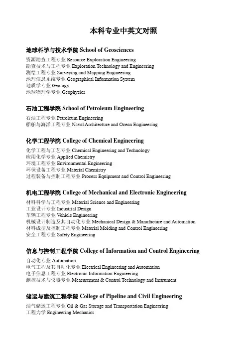
本科专业中英文对照地球科学与技术学院School of Geosciences资源勘查工程专业Resource Exploration Engineering勘查技术与工程专业Exploration Technology and Engineering测绘工程专业Surveying and Mapping Engineering地理信息系统专业Geographical Information System地质学专业Geology地球物理学专业Geophysics石油工程学院School of Petroleum Engineering石油工程专业Petroleum Engineering船舶与海洋工程专业Naval Architecture and Ocean Engineering化学工程学院College of Chemical Engineering化学工程与工艺专业Chemical Engineering and Technology应用化学专业Applied Chemistry环境工程专业Environmental Engineering环保设备工程专业Material Chemistry过程装备与控制工程专业Process Equipment and Control Engineering机电工程学院College of Mechanical and Electronic Engineering材料科学与工程专业Material Science and Engineering工业设计专业Industrial Design车辆工程专业Vehicle Engineering机械设计制造及其自动化专业Mechanical Design & Manufacture and Automation 材料成型及控制工程专业Material Molding and Control Engineering安全工程专业Safety Engineering信息与控制工程学院College of Information and Control Engineering自动化专业Automation电气工程及其自动化专业Electrical Engineering and Automation电子信息工程专业Electronic Information Engineering测控技术与仪器专业Measurement & Control Technology and Instrument储运与建筑工程学院College of Pipeline and Civil Engineering油气储运工程专业Oil & Gas Storage and Transportation Engineering工程力学Engineering Mechanics土木工程专业Civil Engineering热能与动力工程专业Thermal Power and Power Engineering建筑环境与设备工程专业Architectural Environment and Equipment Engineering建筑学专业Architecture计算机与通信工程学院College of Computer and Communication Engineering计算机科学与技术专业Computer Science and Technology软件工程专业Software Engineering通信工程专业Communication Engineering经济管理学院Schlool of Economics and Management工程管理专业Engineering Management信息管理与信息系统专业Information Management and Information System会计学专业Accounting财务管理专业Financial Management国际经济与贸易专业International Economy and Trade行政管理专业Administration Management经济学专业Economics市场营销专业Marketing and Sales公共事业管理专业Public Utility Management电子商务专业Electronic Commerce工商管理专业Business Administration理学院College of Science应用物理学专业Applied Physics材料物理专业Materials Physics材料化学专业Materials Chemistry信息与计算科学专业Information and Computing Science数学与应用数学专业Mathematics光信息科学与技术专业Optical Information Science and Technology文学院College of Arts英语专业English Language and Literature俄语专业Russian Language and Literature音乐学专业Musicology法学专业Science of Law艺术设计专业Art Design汉语言文学专业Chinese Language and Literature。
专业英语练习一Exercise One1.Explain the meaning of each of the following technical terms in English and write the corresponding technical term in Chinese.2.解释下列术语中的每一个技术术语的含义,并在中文书写相应的技术术语。
1) Geomatics 测绘学;2) geoinformatics地理信息技术;地理信息学2. Answer the following questions in English.用英语回答下面的问题。
1) What does the term Geomatics mean?2) What are the sources of spatial data comes from? 空间数据的来源是什么?3) What kind of disciplines can Geomatics find its application? 什么样的学科地理信息学能找到它的应用吗?3. Write the corresponding English terms of the Chinese terms写相应的英语术语的术语1) 测绘学2) 大地测量学3) 测绘4) 摄影测量学5) 遥感6) 全球定位系统7) 卫星定位8) 地理信息系统10) 土地管理11) 计算机图形学4. Translate the following sentences into Chinese. 把下列句子译成中文。
1) Geomatics is a field of activities which, using a systemic approach, integrates all the means used to acquire and manage spatial data required as part of scientific, administrative, legal and technical operations involved in the process of the production and management of spatial information.课本p7 Notes③2) The term geomatics emerged first in Canada and as an academic discipline; it has been introduced worldwide in a number of institutes of higher education during the past few years, mostly by renaming what was previously called “geodesy”or “surveying”, and by adding a number of computer science-and/or GIS-oriented courses. 课本p7 Notes①3) Geomatics is the modern scientific term referring to the integrated approach of measurement, analysis, management, storage and display of the descriptions and location of Earth based data, often termed spatial data. These data come from many sources, including earth orbiting satellites, air and sea-borne sensors and ground based instruments. It is processed and manipulated withstate-of-the-art information technology using computer software and hardware. It has applications in all disciplines which depend on spatial data, including environmental studies, planning, engineering, navigation, geology and geophysics, oceanography, land development and land ownership and tourism. It is thus fundamental to all the geoscience disciplines which use spatially related data. [from the School of Geomatic Engineering, Univ. of New South Wales] 测绘学是现代科学术语,指的是地球基础数据(通常被称为空间数据)的描述和位置的测量,分析,处理,存储和显示的综合办法。
地理信息科学专业考研科目【实用版】目录1.地理信息科学专业简介2.地理信息科学专业考研的重要性3.地理信息科学专业考研科目4.各科目备考策略与建议正文【地理信息科学专业简介】地理信息科学专业是一门综合性的学科,涉及地理学、测绘学、计算机科学等多个领域。
该专业旨在培养具备地理信息系统(GIS)理论、技术与应用能力的高级专门人才。
地理信息科学专业的毕业生将在城市规划、环境保护、资源管理等领域发挥重要作用。
【地理信息科学专业考研的重要性】随着我国经济的快速发展和信息化水平的不断提高,地理信息科学专业的社会需求逐年增加。
考研成为许多地理信息科学专业毕业生提升自身学术水平和就业竞争力的重要途径。
此外,通过考研,学生还可以深入学习地理信息科学的前沿理论和技术,为今后的职业生涯奠定坚实基础。
【地理信息科学专业考研科目】地理信息科学专业的考研科目主要包括以下几个方面:1.政治:主要包括马克思主义哲学、中国特色社会主义理论体系、科学社会主义和国际共产主义运动等。
2.英语:主要包括英语词汇、语法、阅读理解、写作和翻译等。
3.数学:主要包括高等数学、线性代数、概率论与数理统计等。
4.专业课:主要包括地理信息系统原理、地理信息科学理论与方法、遥感技术与应用、地理空间分析等。
【各科目备考策略与建议】1.政治:建议考生提前规划学习时间,掌握考试大纲要求的知识点,注重理论与实际相结合。
同时,要关注时事政治,密切关注党和国家的重大政策方针。
2.英语:建议考生提高词汇量,加强阅读理解能力,熟练掌握写作和翻译技巧。
此外,要注重听力和口语的训练,提高英语实际应用能力。
3.数学:建议考生从基础知识入手,逐步提高解题能力。
要注重题型和解题方法的总结与归纳,多做真题和模拟题,提高应试水平。
4.专业课:建议考生深入理解地理信息科学专业的基本理论和方法,掌握相关技术的应用。
要关注学术前沿,了解行业发展动态。
同时,要注重实际操作能力的培养,提高解决实际问题的能力。
地理英语知识点总结大全地理英语知识点总结主要包括地理学的基本概念和相关术语、地理环境、地球系统、自然灾害、地理信息系统等内容。
以下是地理英语知识点的详细总结:一、地理学基本概念和相关术语1. 地理学(Geography):研究地球上的自然和人文现象及其相互关系的学科。
2. 地球(Earth):位于太阳系中的第三颗行星,是目前已知的宇宙中唯一能够支持生命的行星。
3. 球面(Spherical):地球的形状是近似于一个球体,这种形状称为球面。
4. 经度(Longitude)和纬度(Latitude):经度是以格林威治天文台为标准,由东经0°至西经180°,由西经0°至东经180°;纬度是以赤道为基准,由北至南90°。
5. 地理坐标系(Geographic coordinate system):用经度和纬度来描述地球上的地理位置。
6. 自然环境(Natural environment):地球上的自然元素组合,包括气候、地貌、水文、生物等。
7. 人文环境(Human environment):人类活动对自然环境的影响,在地理学中具有重要意义。
8. 地形地貌(Topography):地球表面的地势和形态。
9. 气候(Climate):一定地区长期的天气状况的总和。
10. 生物圈(Biosphere):地球上所有生物的聚集体,包括陆地、海洋和海底等。
11. 地理信息(Geographic information):地球表面物体的位置和属性信息,包括地图、影像、遥感数据等。
12. 地理信息系统(Geographic Information System,GIS):用于收集、存储、处理、分析、显示和管理地理信息的系统。
13. 地理范围(Geographic extent):地理学中指地球上某一地域的区域范围。
14. 地理学家(Geographer):专门从事地理学研究和实践的学者和专业人士。
地理信息科学专业(专业代码:070504学制:四年学位:理学学士)一、培养目标本专业培养系统掌握地理信息科学的基本理论、基本方法和基本技能,具有较扎实的地理信息系统、遥感、卫星定位、地图学、地理学等领域的专门知识,具有较强计算机实践能力、创新意识和国际视野,能在地理信息学科、测绘学科以及石油、海洋、国土、规划、水利、环境、地勘、不动产、信息产业、交通等领域从事研究、教学、地理信息系统设计、开发以及管理工作的高级复合型人才。
通过5年左右实际工作的锻炼,期望毕业生成长为科研岗位、技术研发岗位和工程设计岗位的骨干,达到:1.具备合格的科研工作者、地理信息工程师和技术管理者的素质和能力;2.具有良好的文化修养与道德水准,有意愿并有能力服务社会;3.具有团队协作、创新和科学探索精神,具备良好的职业素养和终身学习的能力,能够紧跟地理信息科学相关领域新理论和新技术的发展;4.能在一个设计、研发或科研团队中担任重要角色,具有运用所学知识从事地理信息工程及技术创新的能力;5.能够独立从事地理空间信息的工程设计、应用研究和信息化技术管理工作。
二、毕业要求及实现矩阵本专业毕业生应获得以下几个方面的知识和能力:1. 具有人文素养、身心素质、职业素养、科学精神和社会责任感,了解相关法律、法规及政策,了解国情社情民情,践行社会主义核心价值观;2. 具有从事地理信息科学工作所需的数学、物理、计算机方面的基础知识,能够有效应用这些知识和工具解决本专业领域的描述、建模、分析决策等相关问题;3. 系统掌握地理信息科学、遥感、测绘的基础理论和实践技能,具有地理空间逻辑思维、数据采集、处理、遥感图像信息提取的能力,了解学科领域的发展前沿和趋势,能够发现、辨析、质疑、评价本专业领域的问题,并表达个人见解;4.掌握数字油田、数字海洋及空间信息集成技术的理论、方法和技能,能够对本专业领域复杂问题进行综合分析和研究,具有解决复杂问题的能力,并提出相应对策或解决方案;5.具有信息技术应用能力,能够恰当使用现代工具对地理信息科学领域信息资料进行收集、处理和分析,解决实际问题;6. 具有较强的英语运用能力,具有听、说、读、写、译的技能,能较顺利阅读本专业的外文文献;7. 具有一定的组织管理知识和能力,具有较强的团队意识和协作精神,能够在多学科背景下的团队中承担个体、团队成员以及负责人的角色;8. 具有国际视野和国际理解能力。
1、Geographical information systems 地理信息系统Geo-referenced data 地理参照数据 data capture 数据获取Data integration 数据集成projection and registration 投影与匹配Data structures 数据结构information retrieval 信息检索Topological modeling 拓扑建模network analysis网络分析Overlay 叠置 data output 数据输出2、discrete objects 离散对象raster data 格数据Vector data 矢量数据continuous fields 连续字段Spatial data model 空间数据模型digital terrain model(DTM)数字地面模型Digital elevation model(DEM)数字高程模型Exhaustive enumeration 穷举法run-length encoding 行程长度编码Hierarchical file 层次文件relational file 关系文件3、geo-referencing 空间参照geodesy 大地测量学Map projections 地图投影coordinate systems 坐标系统Datum 基准面ellipsoid 椭球体Geoid大地基准面gravity 万有引力Earth’ s spherical graticule 地球球面坐标网Cartesian coordinates 笛卡尔坐标Lambert azimuthal equal-area projection 朗伯等积方位投影Polar coordinate 极坐标gnomonic projection 心射切面投影Albers equal-area conic projection 阿尔伯斯等积圆锥投影Developable surface 投影面orthographic projection 正射投影4、location 定位attribute 属性Arcs(lines)弧线polygons(traversed areas)多边形Points(labeled nodes)点(标识节点) nodes (intersection points)节点(交汇点)Data collection 数据采集color aerial photograph 彩色航空照片Synthetic aperture radar 合成孔径雷达benchmark point 基准点Scanner 扫描仪on-screen / heads-up digitizing 幕数字化Uncertainty 不确定性error 误差Accuracy 准确性precision 精确性Topology creation 拓扑创建indexing 索引5、spatial analysis 空间分析database query 数据库查询Reclassification 重分类generalization 概括Ranking 分级geometry 几何学Overlay analysis 叠加分析connectivity analysis 连通性分析Spatial interpolation 空间插值standard query language(SQL)标准化查询语言Polygon 多边形proximity analysis 邻近域分析Network analysis 网络分析Geo-statistics 地统计学Inverse distance weighted interpolation(IDW)反距离加权内插法Geo-visualization 空间可视化6、environmental management and conservation 环境管理与保护Environmental planning 环境规划landscape 景观Environmental hazards and risks 环境灾害与监测Environmental assessment and monitoring 环境评价与监测Environmental model 环境模型air pollution & control 大气污染与控制Disaster management 灾害管理public health 公共卫生Site analysis 位置分析health insurance organization 健康保险组织Health care 卫生保健7、remote sensing 遥感sensor 传感器Electromagnetic radiation 电磁辐射radiometer 辐射计Electro-optical scanner 光学扫描仪radar system 雷达系统Platform 遥感平台electromagnetic spectrum 电磁波谱Electrical field 电场magnetic field 磁场Blackbody 黑体Planck radiation law 普朗克定律Stefan-Boltzmann’s law 波尔兹曼定律Wien’s displacement law 维恩位移定律Rayleigh scattering 瑞利散射Mie scattering 米氏散射Nonselective scattering 非选择性散射atmospheric windows 大气窗口specular reflector 镜面反射perfect diffuse reflector 漫反射(朗伯反射)irregular reflector 不规则反射spectral reflectance curve 反射波谱曲线8、platform 遥感平台meteorological satellite 气象卫星TIRO-1(Television and Infrared Observation Satellite-1)电视和红外辐射观测卫星-1Near-polar orbit 近极地轨道sun-synchronous 太阳同步轨道GOES(Geostationary Operational Environmental Satellite)静止同步环境应用卫星Advanced Very High Resolution Radiometers(AVHRR)甚高分辨率辐射计Return beam vidicon 反束光导摄像管multispectral Scanner(MSS)多光谱扫描仪Thematic Mapper 专题测图仪pushbroom 推扫式SPOT(Systeme Pour l’ Observation de la Terre)地球观察卫星系统CNES(Centre National d’ Etudes Spatiales国家空间研究中心)high resolution visible(HRV)sensors 高分辨可视成像传感器Charge-coupled devices (CCDs)电荷耦合器件panchromatic(PLA)全色multispectral(MLA)多波段WFI(Wide Field Imager)广角成像仪 earth observing system(EOS)地球观测系统CBERS(China-Brazil Erath Resources Satellite)中巴地球资源卫星IRMSS(Infrared Multispectral Scanner) 红外多光谱扫描仪MODIS(Moderate Resolution Imaging Spectro-radiometer)中分辨率成像光谱仪Coastal Zone Colour Scanner(CZCS)海按去彩色扫描器Marine Observation Satellite (MOS) 莫斯(海洋观测卫星)Multispectral Electronic Self-scanning Radiometer (MESSR) 多光谱电子自扫描仪辐射计Visible and Thermal Infrared Radiometer (VTIR) 可见光与热红外辐射计Microwave Scanning Radiometer (MSR) 微波扫描辐射计SeaWiFS(Sea-viewing Wide-Field-of View Sensor)海洋观测广角感测仪RADAR(radio detection and ranging)雷达(无线电测距与定位)All weather 全天候altimeter高度计Scatterometer 散射计pulse 脉冲Backscattered 后向散射polarization 极化Real aperture radar(RAR)真是孔径雷达 range or across-track resolution 距离分辨率Azimuth or along-track resolution 方位分辨率beamwidth 脉冲宽度Synthetic aperture radar(SAR) 合成孔径雷达Doppler effect 多普勒效应9、analog image 模拟图像digital image 数字图像Pixel 像素spectral resolution 光谱分辨率Radiometric resolution 辐射分辨率spatial resolution 空间分辨率Temporal resolution 时间分辨率instantaneous field of view(IFOV)瞬时视场角Channel / band波段radiometric correction 辐射校正Sensor correction 传感器校正atmosphere correction 大气校正Illumination and geometry correction 照明与地形校正Geometric correction 几何校正ground control point 地面控制点Nearest neighbor 最邻近法bilinear interpolation 双线性内插法Cubic convolution 三次卷积内插法resampling 重采样Contrast enhancement 对比增强image histogram 图像直方图Linear contrast stretch 线性拉伸法histogram-equalized stretch直方图均衡法Spatial filtering 空间域滤波convolution filter 卷积滤波Low-pass(smoothing)filter 低通(平滑)滤波image integration 数据融合High-pass(sharpening)filter 高通(锐化)滤波Laplacian filter 拉普拉斯算子滤波Directional,or edge detection filter 方向 / 边缘检测滤波Image arithmetic operations 图像运算addition of images 图像加和运算Multiplication of image图像乘积运算image division or spectral ratioing 图像比值运算Normalized difference vegetation index(NDVI)归一化植被指数Hue,saturation and intensity (HIS)transform HIS(色调,明度和饱和度)变换Hexcone model 六角锥体模型 image transformation 图像变换Image subtraction 图像差值运算principal components analysis 主成分分析Digital elevation or digital terrain models(DEMs / DTMs)数字高程 / 地形模型10、tone 色调shape 形状size 大小Site 位置pattern 图型texture 纹理Shadow 阴影 association 布局Spectral pattern recognition 光谱模式识别supervised classification 监督分类Unsupervised classification 非监督分类training area 训练区Minimum-distance classification 最小距离分类法Euclidian distance 欧氏距离Normalized Euclidian distance 标准欧氏距离mahalanobis distance 马氏距离Parallelpiped classfier 平心分类法clustering algorithms 聚类算法maximum likelihood classification(mlc)最大似然比分类法hierarchical clustering 分级集群法non- hierarchical clustering 非分级聚类法isodata method 迭代自组织数据分析技术accuracy assessment 精度评价field check 野外复核11、vegetation remote sensing 植被遥感biodiversity protection 生物多样性保护Plant pigmentation 植物色素internal leaf structures 叶子内部构造In vivo water content 有积水成分anthocyanin 花青素Deciduous and coniferous trees 落叶树与针叶树ratio vegetation index 比值植被指数Difference vegetation index 差值植被指数perpendicular vegetation index 正交植被指数Geological remote sensing 地质遥感sedimentary rock 沉积岩Magmatic rock 岩浆岩metamorphic rock 变质岩Fault 断层fold 褶皱Syncline 向斜anticline 背斜Lineament 线性构造water remote sensing 水体遥感Flood delineation & mapping 洪水范围与制图dust storm 沙尘暴land cover / use remote sensing 土地覆被 / 利用遥感clouds and snow remote sensing 云体与雪遥感MISR多角度成像光谱辐射计12、global positioning system(GIS)全球(卫星)定位系统 Doppler shift 多普勒频移Pseudo-random noise(PRN)伪随机噪声pseudo-ranges 伪距Code division multiple access(CDMA)码分多址连接方式 orbital planes 轨道平面GPS signal GPS信号navigation information 导航信息Receiving antenna 接收天线preamplifier 前置放大器Resection 后方交会13、topography 地形面reference ellipsoid 参考椭球面Geoid 大地水准面coordinate 坐标Coordinate system 坐标系统datum 基准Coordinate reference system 坐标参照系reference frame 参考框架Transformation 转换space-fixed reference system 空固参照系Earth-fixed reference system 地固参照系celestial reference frame (CRF)天球参考框架Terrestrial reference frame (TRF)地球参考框架International celestial reference frame(ICRF)国际天球参考框架International terrestrial reference frame(ITRF)国际地球参考框架Conventional terrestrial reference system (CTRS)协议地球参照系World geodetic system 1984(WGS-84) 1984世界大地系统Height / elevation 高程orthometric height 正高Normal height 正常高geodetic / ellipsoidal height 大地高Height anomaly 高程异常coordinated universal time(UTC)协调世界时International atomic time (TAI)国际原子时leap seconds 闰秒(或跳秒)14、carrier frequencies 载波频率modulate 调制PRN codes 伪随机噪声吗coarse acquisition(or C/A-code)粗/截获码(C/A码)Precision (or P-code)精码(P码) chipping rate 基码速率Biphase modulation 双向调制antispoofing(AS)反欺骗政策(AS)Clock correction 钟差改正satellite almanac 卫星历书Synchronization error 正弦波signal loss(or cycle slips)信号失锁(周跳)15、random errors 偶然误差biases (systematic errors)偏差(系统误差)Selective availability 选择可用性政策(AS)ephemeris error 星历误差Clock error 钟差multipath error 多路径误差Antenna-phase-center variation 天线相位中心位置偏差Receiver measurement noise 接收机测量噪声ionospheric delay 电离层延迟Tropospheric delay 对流层延迟Time DOP(TDOP)钟差精度因子Geometric locations of the GPS satellites 卫星的空间几何分布Dilution of precision (DOP)几何精度因子position DOP(PDOP)三维位置精度因子Vertical DOP(VDOP)垂直分量精度因子horizontal DOP(HDOP)水平分量精度因子Geometric DOP (GDOP)(PDOP与TDOP的)综合影响精度因子Covariance matrix 协方差矩阵user equivalent range error(UERE)用户等效距离误差16、point positioning 单点定位relative positioning 相对定位Least-squares estimation 最小二乘估计Kalman filtering 卡尔曼滤波Differential positioning 差分定位static GPS surveying 静态GPS测量Fast/rapid static surveying 快速静态测量fixed solution 固定解Float solution浮点解kinematic GPS surveying 动态GPS测量RTK surveying 实时动态测量baud rate 波特率Real-time difference GPS (DGPS)实时差分GPS Radio technical commission for maritime service(RTCM)海事服务无线电技术委员会Omnidirectional antenna 全方位天线position data link (PDL)定位数据链接Low/medium frequency(LF/MF)bands 低/中频波段Very high and ultrahigh frequency (VHF/UHF)bands 高/超高频波段17、location 定位 navigation 导航tracking 跟踪Mapping 制图timing 授时Military applications 军事应用civilian applications 民事应用18、integration 集成semantic information 语义信息Non-semantic information 非语义信息spatio-temporal data 时空数据Inertial navigation system(INS)惯性导航系统charge-coupled device(CCD)电耦合器件Exterior orientation elements 外方位元素expert system 专家系统Spatial visualization 空间可视化multi-system 多尺度Multi-date 多时相image fusion 图像融合Generalization 综合components approach 分量方法Digital line graphic 数字线画图vector data 矢量数据Pattern recognition 模式识别Database management system (DBMS)数据库管理系统Aerotriangulation without the ground control points 无地面控制的空中三角测量Geo-spatial information science (geo-matics)地球空间信息学Digital earth 数字地球。