Robust Node Localization for Wireless Sensor Networks ABSTRACT
- 格式:pdf
- 大小:130.72 KB
- 文档页数:5

“科技信息检索与论文写作课程”专业课题检索报告课题名称:无线传感器网络三维节点定位算法的研究姓名:于彦波学号: 1142201439 专业:电子与通信工程导师签字:完成时间: 2015 年01月01日检索报告要求一、本报告用计算机或钢笔认真如实完成。
二、本报告包括两个部分,第一部分包括课题名称、关键词、中英文检索式、检索结果(中英文文献不少于30篇,并按标准格式列出,涉及中英文数据库不少于8个);第二部分要求完成一份综述报告,包括本课题的国内外发展现状及趋势、主要的研究机构与专家等。
三、课题名称自选,范围是与所学专业相关的题目,由导师直接命题,于第一次课后至第二次课前选定。
从第二次开始,利用每个讲座安排的上机时间,结合自己的课题完成与本讲内容相应的中英文文献检索,包括相关的期刊、学位论文、专利、成果等文献的检索。
四、课余时间完成综述报告,并由导师签字后上交。
五、无论在教室还是在机房,请务必在最后一次课前完成并上交。
一、课题分析二、检索过程明细1. 检索策略中文检索式(如:主题=(关键词1)or(关键词2))英文检索式2. 检索结果列表(同一数据库使用多种检索式时,记录不同结果可拆分表格)三、综述报告(两个课题分别写)1.本课题主要研究内容本课题首先对无线传感器网络进行了阐述,并对其有关的概念进行了分析,然后对本课题重点即定位技术作了详细的分析,对已有的节点定位算法进行了详细的分析和研究,归纳和总结一些经典的定位算法,并在此基础上重点研究了测距质心定位算法,分析了该算法存在的不足之处和局限性,提出了不同的改进策略。
计划设计完成算法方案之后,利用仿真工具MATLAB对提出的改进和设计算法进行仿真、分析和对比。
实验仿真结果主要从锚节点密度和节点通信半径等几个方面进行比较。
比较观察到的结果表明,提出的新算法在定位精度和定位率上都有一定的程度上提高。
2.国内外研究现状无线传感器网络最初起源于美国的一个先进国防科研项目,但由于当时某些条件的限制,使得无线传感器网络的应用只能局限在军方领域,但近几年来,数字电子技术、无线通信和微电子技术等技术的进步,大力地推动了低功耗多功能无线传感器网络在各个领域的快速应用和发展。
基于RSS-IWLS的认知无线电系统主用户定位算法李洪兵;陈斌斌;廖玉祥;冯文江【摘要】In this paper, it proposes a novel primary user positioning algorithm RSS-IWLS-based to estimate the position and transmission power of the primary user at the same time in cognitive radio systems. The proposed algorithm considers the practical factors not only path loss but also shadowing effect and channel noise that affect the estimation accuracy. The simulation results show that the proposed algorithm is better than RSS-LS algorithm in estimation accuracy.%在认知无线电系统中,主用户定位是执行无线传输场景分析,进而共享主用户频谱资源,提供基于位置辅助业务的前提条件。
针对主用户发射信号功率未知情况,提出一种基于接收信号强度的改进加权最小二乘(RSS-IWLS)算法实现在对主用户定位的同时估计其发送功率。
该算法综合考虑路径损耗、阴影效应和信道噪声对定位精度的影响。
仿真结果表明,执行RSS-IWLS算法获得的主用户位置估计精度比基于接收信号强度的最小二乘算法更高。
【期刊名称】《计算机工程与应用》【年(卷),期】2016(000)002【总页数】5页(P146-150)【关键词】认知无线电系统;主用户定位;接收信号强度;加权最小二乘算法【作者】李洪兵;陈斌斌;廖玉祥;冯文江【作者单位】国网重庆市电力公司江北供电分公司,重庆 401120;重庆大学通信工程学院,重庆 400044;国网重庆市电力公司江北供电分公司,重庆 401120;重庆大学通信工程学院,重庆 400044【正文语种】中文【中图分类】TN92LI Hongbing,CHEN Binbin,LIAO Yuxiang,et al.Computer Engineering and Applications,2016,52(2):146-150.认知无线电[1]通过择机占用主用户空闲频谱,与主用户共享资源,能缓解频谱资源短缺与宽带业务需求之间的矛盾。
第36卷增刊(I)2006年7月 东南大学学报(自然科学版)JOURN AL OF SO UTHEAST UNI VERSITY (Natural S cience Edition ) Vol 136S up (I)July 2006 APIT 技术在目标定位中的应用王 磊1 王月清1 张 萍1 孙 涛1 田 斌1 柴远波2 段富强1(1海军工程大学电子工程学院,武汉430033)(2解放军信息工程学院信息技术研究所,郑州450002)摘要:提出了在无线传感器网络中目标定位与节点定位采用同一种技术———APIT 技术,即以三角形内的点近似定位算法来对未知节点和目标进行定位,这种算法仅需要少量通信和简单计算,同时还具有良好的扩展性,从而为进一步的研究提供了一个可行的思路.关键词:无线传感器网络;定位方法;位置估计中图分类号:T N915;TP301 文献标识码:A 文章编号:1001-0505(2006)增刊(I)20201203Application of a ppr oximate PIT technology in object positioningWang Lei 1 W ang Yueqing 1 Zhang Ping 1 S un T ao 1 Tian Bin 1 Chai Y uanb o 2 Duan Fuqiang1(1C ollege of Electroni c Engineering ,Naval Engi neering Univers i ty ,W uhan 430033,C hi na)(2Inform ati on T echnique G raduate School ,Uni vers ity of Inform ation and Engi neering of P LA ,Z hengzhou 450002,C hina )Abstract : An APIT technology —appr oximate localization algorithm —was adopted in the positioning of ob 2ject and node localization of wireless sensor netw orks.Fe w corresponding and sim ple c omputation are needed in this alg orithm.I t is extensible ,which can pr ovide a feasible mentality for the fur t her research.K ey w or ds : w ireless sens or netw orks ;positioni ng approaches;position estimation 收稿日期622 作者简介王磊(—),男,硕士生,@63;王月清(联系人),女,副教授,硕士生导师随着计算机技术和无线电通信技术的发展,普适计算(ubiquitous c omputing)将被应用在各种领域,融入到人们的日常生活中,提高人们的生活质量和水平.普适计算的一个前提条件是必须获取普适计算对象的位置信息[1],这个位置信息依据普适计算的不同具体应用,可以是基于区域范围的,也可以是基于精确坐标的.在无线传感器网络(W SN )中也同样面临着普适计算的需求.有很多定位技术都可以对物体进行定位,但适合普适计算要求的、对多个移动物体精确定位的、系统电子复杂性[2]低的技术却并不多.基于API T 定位技术是一种可行的、适合WS N 普适计算要求的定位技术.图1 目标定位区域示意图(○—节点;●—目标物体)1 APIT 算法分析无线传感器网络中存在两类定位技术,一是节点自定位技术,二是目标定位技术.APIT 作为在节点定位技术中应用比较成熟的技术,我们把它引入到目标定位技术中,这样在网络优化、减少系统电子复杂性、降低成本上将有很大的期望.在讨论这个问题之前,首先归纳出算法运行的环境.APIT 使用一个新的基于区域的方法来执行定位估测,这个方法将环境分离成anchor 节点间的三角形区域,用一个网格算法计算某个目标可能所在的最大区域.基本思想是,目标从所有听得见的anchors 中选择3个anchors ,然后连接这三个anchors ,构成一个三角形,判断目标是否:2000420.: .在三角形中.然后APIT 对不同的anchors 组合重复测试,直到测试完所有的组合或者得到要求的精确度为止.最后,计算所有包含目标的三角形的交集的质心,以此决定目标的大致位置.由于APIT 要求anchors 的密集度高,因此只适合anchors 节点密集的传感器网络.首先要考虑的是需要传感器网络是自组织的[3],假定节点都是已知的.为了简化和易于表示,限定在二维空间.假定所有的节点都位于区域内,如图1所示.在这种算法中如何确定目标物体在最近的3个节点所构成的三角形中.可以用到达时间及时间差测距法.到达时间(TO D )技术通过测量信号传播时间来测量距离.在TO A 方法中,若电波从节点到目标物体的传播时间为t ,电波传播速度为c ,则节点到目标物体的距离为t ×c .比较到各个节点的时间从而选出最短距离的节点构成三角形区域,如图2所示.图2 三角区域测试距离示意图(A:目标物体N :节点d :距离)在确定三角形区域后,测试目标物体在这三个节点所组成的三角形内部还是外部;然后再选择另外三个节点进行同样的测试,直到达到所需的精度.如果目标物体在三角形内部则这个三角形区域的质心作为估计位置[4].APIT 算法最关键的步骤是测试目标物体在三个节点所组成的三角形内部还是外部,这一测试的理论基础是三角形内的点(PI T )测试.PIT 测试用来测试目标物体是在三个节点所组成的三角形内部还是外部,其原理如图3所示.假如存在一个方向,沿着这个方向M 点会同时远离或者同时接近A 、B 、C 三个点,那么M 位于ΔA BC 外;否则M 位于ΔA BC 内.这就是PIT 测试的原理,其证明可以在文献[5]中找图3 PIT 测试示意图到.在静态目标物体,M 点固定,不能朝着不同的方向移动,此时无法执行PIT 测试,为此定义APIT 测试,如图4所示.假如目标物体M 的邻居节点中没有同时远离或同时靠近三个节点A ,B ,C 的节点,那么M 就在ΔA BC 之内;否则M 就在ΔA BC 之外.如图4中,目标物体M 通过与邻居节点1交换信息,得知自身运动至节点1,将远离节点B图4 APIT 示意图和C ,但会接近节点A ,与邻居节点2,3,4的判断过程类似,确定自身位于ΔA BC 内,而在图4的右图中,目标物体M 可知假定自身运动至邻居节点2处,将同时远离节点A ,B ,C ,故判断自身不在ΔABC 中.当目标物体M 比较靠近ΔA BC 的一条边,或者M周围的邻居节点分布不均匀时,APIT 的判断可能会发生错误,当节点密度越大,则APIT 判断发生错误的概率越小.2 结 语用APIT 技术对目标进行定位需要进一步解决的问题是:①降低距离相关的算法产生的距离误差.②距离无关的算法中有较稀疏节点时,目标可能不被多个已知节点包围下一步的工作是研究距离测量错误及稀疏对定位性能的影响,并针对现有定位算法的不足,提出三阶段的定位算法,包括距离测量、目标定位和迭代精确三个阶段202东南大学学报(自然科学版)第36卷anch ors .an ch or .参考文献(References)[1]付维权,孙志仁,曹奇英.普适计算中的定位感知系统[J ].单片机与嵌入式系统应用,2004(2):15218.Fu W eiquan ,Sun Z hiren ,Cao Qiying.Orientation apperceive sys tem in general suitab le account [J ].M icro controller &Embedd ed Sy stem ,2004(2):15218.(in Chinese )[2]雷鸣雳,周功道,冯祖仁.基于伪码相关技术的超生波2无线电定位系统[J ].微电子学与计算机,2004,24(3);1022106.Lei M ing li ,Z h ou G ongd ao ,Fen g Zuren.U ltras on ic 2radio wav e location s ystem based on pseud o 2rand om correlation techn ology[J ]Mi 2croelectronics &C omputer ,2004,24(3):102-106.(in Chinese )[3]周正.无线传感器网络节点自定位技术[J ].中兴通讯技术,2005,11(4):51256.Z h ou Zh eng.Self 2l ocalizati on techn olog ies for w ireless sens or n etw ork nodes[J ].Zh ongxing Teleco m T echnology ,2005,11(4);51-56.(in Ch inese)[4]李国华,刘宝铃,沈树群.基于超声波技术的3D 定位系统研制[J ].计算机测量与控制,2005,13(9):9262928.Li G u ohua ,Liu Baoling ,Shen Shuqun.Research and dev elopment o f 32D P ositioning s ystem based on the ultras ound techn olog y[J ].Compu ter Au to mated M easurement &Con tro l ,2005,13(9):926-928.(in Ch inese)[5]He T ian ,Huang Chengdu ,Blum B M ,et al.Range 2free l ocalizati on schemes in large scale sens or netw orks [C]//Proceeding s o f th e9th Annual International Con feren ce on Mo bile Co mputing and Network ing ,M OBIC OM ’2003.N ewY ork :A CM Press ,2003:81295.302增刊(I )王磊,等:APIT 技术在目标定位中的应用。
抵御虫洞攻击的无线传感器网安全定位算法陈立建;金洪波;毛科技;苗春雨;邬锦彬;陈庆章【摘要】Localization is a pivotal technology in wireless sensor networks and location information of sensor nodes is essential to location-based applications. Wireless sensor network is a dynamic network,which is re-localized for a time. However,attackers are invaded easily and influence the re-localization. In this paper,we analyze the influence of wormhole attack on DV-Hop firstly. Then,a Trust-Model-based DV-Hop localization against wormhole attack is proposed. The simulation results shows that the proposed TMDV-Hop can efficiently reduce the effects of the worm?hole attack on the DV-Hop re-localization without extra-hardware,which validates the effectiveness of the proposed algorithm.%节点定位技术是无线传感器网络的支撑技术之一,节点位置信息是很多基于无线传感器网络的应用的基础.无线传感器网络是一个动态的网络,每隔一段时间需要进行重新定位,并且在重定位过程中易受到攻击节点攻击.针对无线传感器网络中无需测距的定位技术,分析虫洞攻击对DV-Hop定位的影响,提出了一种基于信誉模型的抵御虫洞攻击的分布式轻量级DV-Hop安全定位算法TMDV-Hop(Trust-Model-based DV-Hop Localization Against Wormhole Attack).仿真表明,在无需额外硬件辅助下,TMDV-Hop算法能有效降低虫洞攻击对定位过程的影响,验证了该算法的有效性.【期刊名称】《传感技术学报》【年(卷),期】2016(029)012【总页数】6页(P1882-1887)【关键词】无线传感器网络;安全定位;DV-Hop;虫洞攻击;信誉模型【作者】陈立建;金洪波;毛科技;苗春雨;邬锦彬;陈庆章【作者单位】浙江广播电视大学萧山学院,杭州311201;浙江工业大学计算机科学与技术学院,杭州310023;浙江工业大学计算机科学与技术学院,杭州310023;浙江工业大学计算机科学与技术学院,杭州310023;浙江工业大学计算机科学与技术学院,杭州310023;浙江工业大学计算机科学与技术学院,杭州310023;浙江工业大学计算机科学与技术学院,杭州310023【正文语种】中文【中图分类】TP393无线传感器网络 WSNs(Wireless Sensor Networks)由大量传感器节点组成,已经广泛的应用在军事和生产生活中,例如战场监视、环境监测和卫生医疗方面[1]。
基于Schmidt正交单位化的稀疏化定位算法赵春晖;许云龙;黄辉;崔冰【摘要】To improve the localization accuracy of a node in the wireless sensor network with a mobile beacon node, a sparse localization algorithm using Schmidt orthonormalization ( SLSO) was proposed. With the SLSO, the node localization problem was converted to a reconstruction problemof the sparse signal by gridding the sensing area, and a new observation matrix which is able to effectively satisfy the restricted isometry property ( RIP ) was obtained by Schmidt orthonormalization. To solve the problem of the sparse signal being approximately sparse in the model, a centroid algorithm was adopted to improve the localization accuracy. The experiment results show that, compared with MAP algorithms, SLSO has better localization accuracy, and requires less broadcasting times.%为了提高在一个移动信标节点下的无线传感器网络节点定位的精度,提出了一种稀疏化的无线传感器网络节点定位算法。
一种基于迭代聚类的无线传感器网络定位算法(英文)罗海勇;李慧;赵方;彭金华【期刊名称】《中国通信:英文版》【年(卷),期】2011(8)1【摘要】In wireless sensor networks,node localization is a fundamental middleware service.In this paper,a robust and accurate localization algorithm is proposed,which uses a novel iterative clustering model to obtain the most representative intersection points between every two circles and use them to estimate the position of unknownnodes.Simulation results demonstrate that the proposed algorithm outperforms other localization schemes (such as Min-Max,etc.) in accuracy,scalability and gross error tolerance.【总页数】7页(P58-64)【关键词】无线传感器网络;定位算法;网络节点;聚类模型;迭代;中间件服务;仿真结果;极大极小【作者】罗海勇;李慧;赵方;彭金华【作者单位】Institute of Computing Technology,Chinese Academy of Sciences;Beijing University of Posts and Telecommunications【正文语种】中文【中图分类】TP212;P228【相关文献】1.一种基于模糊聚类的无线传感器网络定位算法 [J], 邱萌;乔秀全;徐惠民2.一种基于多维标度的分簇迭代无线传感器网络定位算法 [J], 林吉;李晖3.无线传感器网络中一种基于多维定标的迭代定位算法 [J], 陈万明;梅涛;孟庆虎;梁华为;刘玉枚4.一种基于迭代投票的无线传感器网络安全定位算法 [J], 张品;毛文敏;徐静5.一种基于多维标度的分簇迭代无线传感器网络定位算法 [J], 林吉;李晖因版权原因,仅展示原文概要,查看原文内容请购买。

Table of ContentsA Comparative Diagnosis Approach on Transformer’s Insulating OilMing-Jong Lin 1 Research and application based on MOOC courses certification platformBing Xu, Yizhi Zhang 6 The Research on Image Extraction and Segmentation Algorithm inLicense Plate RecognitionWeijian Fang, Xin Zhou 12 Analysis and Applications of Campus Network Flow ControlZhonghua Hu, Weijian Fang 17 A Survey of Computer Network Management TechnologyLi Tan 21 Application of the Cellular Automata Method to Simulation of MultiplePit Similar DefectsRusyn Bohdan, Tors`ka Roxana, Kosarevych Rostyslav 25 Integrated approach to the detection of distributed network attacksGulmira Shangytbayeva, Roza Beysembekova 29 The Study of Enterprise Technical Alliance Comprehensive Profit Allocation Based on Orthogonal ProjectionBo Wang 33 The Spatial Analysis of Monastery on the Qinghai-Tibet PlateauZhuoma CaiJi, Guo Luo, Dayuan Xue, Yuhuan Du 37 Comprehensive Brand Effect: A Data of Automobile BrandsYiweng Yang, Yan Xv, Jianbo Tu, Xuehong Ji 42 Application On the Accidental Vehicle Technology Expertise and Software DevelopmentHaihua Xu, Guangfu Li 49 Airworthiness Management and Engineering Curriculum and its ImplementationJianbo Hu 54 Using MFC and Managed C++ to Realize Configuration UtilityLaiping Wu, Tao Lin, Libin Chen 58 Research on the Relationship between User-to-User Interaction and UserCo-created ValueJianbo Tu, Yan Xu 63Design and implementation of timing tasks based on Avtivti5 Workflow TechnologyJieping Hu, Shulin Yang 68 The Measurement of Corporate Brand: Based on a Stakeholder PerspectiveYiweng Yang, Xinrui Zhang, Zelin Tong, Xuehong Ji 72 Seam the Real with the Virtual:a Review of Augmented RealityRui Zheng, Dan Zhang, Guosheng Yang 77 Reliability Optimization of Electrical Power Systems Subject to Severe Environmental LoadsChunyang Li, Shouhua Chen, Lingwei Li 81 Analysis of photovoltaic Cell Arrangement in the Independent solarPower generating System Installed above Farm LandGezhi Wu, Yu Zhou 87 Fuzzy PID Control System In Industrial EnvironmentHong He, Yu Li, Zhihong Zhang, Xiaojun Xu 91 Research on Data Transmission Method Based 4G in PlatformNingxia Yang, Yongfeng Chen, Min Qin 96 Sports 3D Simulation Technology and Its Application in Minority Sports PopularizationQi Huang, Xiaowei Zou, Haidong Yang 101 Design and Implementation of the Coastal Zone Ecological High Precision Monitoring and Assessment SystemWeiquan Wang, Xueping Zhang, Junkuo Cao 106 Analysis Of Inertial Stability Dynamical For Robot Based On LieAlgebraXinxing Lai, Jin Zhong 111 Design about Simple Tester of Low Capacitance Based on MAX038Liping Zheng 115 Development and Design of General Data Mining SystemBaowen Chen 120 Research on Intelligent Irrigation and Fertilization System In Greenhouse Based on Cloud ComputingLingyun Zhu 124 Analysis and Application of Data Mining Based on Clustering AlgorithmHonghui Lai, Xiaotao Lai 129 Research on Chinese segmentation algorithm based on Hadoop cloudplatformHong Chen 134 The research of land resources e-government system of Henan provincebased on GISXiaoxu Cheng 139 Node Localization Technology of Wireless Sensor Network (WSN) Basedon Harmony Search (HS) AlgorithmYiliang Guo, Bin Mu 145 Research on moving object tracking based on Markov modelCanrong Yao, Shaotao Liu 149 Research on the model design and simulation for training platform basedon network controlFanfan Wang, Lusi Liu, Xiaoli Wang 153 Research on image and video transmission mechanism of the Androidplatform based on 4GJuanjuan Liu, Zhengguang Liu, Zhigang Zhao 159 Research on the Control System of Greenhouse Based on Particle Swarmand Neural NetworkJun Wang, Haiye Yu 164 Efficiency Analysis Of Ground Source Heat Pump In Energy-SavingBuilding Based on Multi Target & Multi ConstraintBing Bai, Chongen Wang 169 Masonry Arch Technology Mortar Joint Control Method and StressAnalysisWeiya Yan 174 REIT Performance and Dynamic Portfolio ConsiderationsKeyu Feng, Yan Yan, Quanbao Li 178 Research on greenhouse intelligent remote control systemJun Wang, Hai Yu 183 24-hour greenhouse temperature prediction model based on the weatherforecastJun Wang, Hai Yu 188 Emergency evacuation simulation in public facilities based on CTMHecheng Zhou, XiaoFang Zhao 196 The Cusp Catastrophe Model of Major Accidents Based on Ideas ofBlack Swan and Its Application in Port Road ProjectsYanfeng Bai, Ling Zhang, Xuejun Wen 201 The Technique and Management of Investment Control in Metro EngineeringShunmao Mao, Tingting Zhu 207 Contrastive Analysis about the Case of Public Bicycle System AmongThree Cities in ShandongChuanzeng Song, Zheng Fa, Xinlei Li, Haiyang Song 212 Single Vehicle Traffic Accidents in Shanghai River-crossing TunnelsYingying Xing, Jian Lu, Chen Wang 219 Eco-Driving --- Current Strategies and issues, A Preliminary SurveyChunxiao Li, Aiping Ni, Jie Ding 226 The Application Research of Operating Vehicle GPS Big Data MiningYao Yu, Ding Chen 235 Research advance of the model of activated sludge process to wastewater treatmentJia Zhou, Limin Ma, Houran Song 240 Applications and platform of Technology-driven financial innovation and integration patterns for LED industrial chain of integrated businessGuoqing Qu, Feng Xiong, Junshi Li 245 Study on All-Phrase FFT Spectrum Analysis Technology in 25Hz SeriesTrack Circuit ReceiverTuo Shen, Lexiang Wei, Xiaoqing Zeng 251 Double T Filter Based New Cable Insulation Detection Approach AndDesign for the Subway TrainPeng Tian, Decun Dong, Hongliang Pan 256 The research on intelligent monitoring system of key tire parameters for automotive driving safety based on vehicular networking264 Huaguang Yang, Lin Xi, Qingquan He, Fengfeng Liu, Ming Yang, Hua Yan,Weimin YangReal time monitoring method for the longitudinal settlement of shieldtunnel using wireless inclinometerJianguo Yin, Hongwei Huang 274 A Potential Based Many-Particle Model for Pedestrian FlowXiaoyang Li, Peng Zhang, Dianliang Qiao, Wong S.C., Choi Keechoo 281 Research on Multidisciplinary Design Modeling of LED Lighting ProductsFeng Xiong, Renfei Ma, Jianjian Mei, Liu Lilan, Yu Tao 287。
2008年6月Journal on CommunicationsJune 2008第29卷第6期 通 信 学 报 V ol.29 No.6分布式无线传感器网络定位算法MDS-MAP(D)马震,刘云,沈波(北京交通大学 通信与信息系统北京市重点实验室,北京 100044)摘 要:针对无线传感器网络的定位问题,提出了一种分布式的算法MDS-MAP(D),明确给出了节点相对坐标计算和局部网络融合的过程,并对算法进行了计算复杂性分析和仿真。
MDS-MAP(D)以分布式节点分簇为基础,利用网络的连接关系,在不需要高精度测距技术支持的条件下对节点坐标进行估计,减小了节点定位的计算复杂度和能量消耗。
分析与仿真结果表明,算法的计算复杂度由3()O N 下降到2(),O Nm m N <,并且定位精度提高了1%~3%。
关键词:无线传感器网络;定位;多维标度;分布式中图分类号:TP393 文献标识码:A 文章编号:1000-436X(2008)06-0057-06Distributed locating algorithm for wireless sensornetworks- MDS-MAP(D)MA Zhen, LIU Yun, SHEN Bo(Key Laboratory of Communication & Information Systems, Beijing Jiaotong University,Beijing Municipal Commission of Education, Beijing 100044, China)Abstract: A new distributed locating algorithm MDS-MAP(D) was proposed, which attempted to improve the perform-ance of node localization in wireless sensor networks. The process of the computation about node relative coordinates and the aggregation from local network to global network are introduced explicitly. Further, the analyses to computational complexity and the simulations of the algorithm are also present. MDS-MAP(D), which is based on node clustering mechanism and uses connectivity of nodes to estimate the coordinates of nodes, reduces the complexity and energy con-sumption of node localization on the absence of distance measurement with high precision. The simulation and analysis results indicate that the complexity of node localization algorithm falls to 2(),O Nm m N < from 3()O N and the accu-racy is improved 1%~3%.Key words: wireless networks; location; multidimensional scaling; distribution1 引言无线传感器网络(WSN, wireless sensor network)技术在最近几年得到了迅速发展,正逐渐被广泛用于军事、交通、环境和工业生产等领域,完成对温度、湿度、压力和速度等许多物理量的测量[1]。
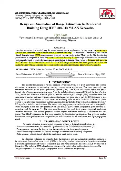
||Volume||2 ||Issue|| 7 ||Pages|| 30-34||2013||ISSN(e): 2319 – 1813ISSN(p):2319 – 1805Design and Simulation of Range Estimation In ResidentialBuilding Using IEEE 802.11b WLAN Networks.Vijay Rayar1,2,Department of Electronics and Communication Engineering, KLE Dr. M. S. Sheshgiri College OfEngineering & technology, Belgaum--------------------------------------------------------ABSTRACT------------------------------------------------------------Location estimation is a critical step for many location aware applications. In this paper we present cost effective and simplified location estimation in residential building. The technique is based only on Received Signal Strength Index (RSSI) measurements taken at receiver nodes using WLAN cards. The localization performance is computed in terms of Cramer-Rao Lower Bound (CRLB) of range estimate under residential environments which is relatively less complex computation technique. This system is designed and tested in MATLAB tool. Simulation results reveal that the CRLB range estimation has better performance than the multilateration with linearization for access point localization algorithm and Eglis propagation model. KEYWORDS : CRLB, Indoor localization, WLAN, MATLAB, RSSI.Date of Submission: 8 July 2013, Date of Publication:25 july,2013I.INTRODUCTIONThe need for localization of wireless nodes in a wireless network is of great importance. The location information is necessary in positioning, tracking, context aware applications. The most commonly used localization technique is the global positioning system (GPS). The indoor localization system has passed through a lot of improvements over the years. From the global positioning system (GPS) and the time of arrival (TOA), to the time difference of arrival (TDOA) and the received signal strength (RSS), researches have been on in areas of analysis and improvements. Among the techniques listed above, only the RSS technique is used mainly for indoor environment. A lot of researches are being under taken in the indoor localization system because of its interesting applications and the numerous factors that affect the propagation of radio frequency (RF) signals in an indoor environment. The indoor radio propagation channel is characterized as site-specific, severe multipath fading and low probability of line-of-sight (LOS) signal propagation path between the transmitter and the receiver [1]. The main contribution of this work is to present improved localization estimation technique. The method proposed exhibits higher localization accuracy, is calibration free and simple. The CRLB‘s presented in this paper quantify the localization performance. The proposed method demonstrates better performance as compared to the multilateration for AP localization and Eglis propagation model.II.CRAMER – RAO LOWER BOUNDParameter estimation in many signal processing systems is designed for applications in:∙Instrumentation —estimate the sinusoidal signal amplitude for DSP based instrumentation [2].∙Power systems —estimate the time varying frequency for single phase electric systems.∙Speech Processing —estimate the spectral envelope and fundamental frequency component.∙Radar systems- estimate target velocity for multi input-multi output radar.In estimation technique the estimator takes the measured data as an input and produces estimate of the parameters. Cramer-Rao lower bound (CRLB) is the widely used estimator and also the estimation method in evaluating performance of wireless localization [2]. The RSSI model and associated CRLB are assessed in this section. The real time RSSI value obtained by the mobile node is taken as Gaussian random variable. Using the log normal shadowing signal propagation model RSSI values are given by:(1) where α is the power measured at a reference distance do assumed to be of 1 m, d is the distance betweenmobile node and the access point (transmitter), n is the path loss exponent, X denotes a Gaussian randomvariable with zero mean caused by shadowing. The power measured at a reference distance, α depends onseveral factors: fast and slow fading, antenna gain, and transmitted power.In general, CRLB is defined as the theoretical lower bound for any unbiased estimator of an unknownparameter . CRLB is obtained for the range dependent model described in Eq. (1) as [2] [5],(2)where is the maximum likelihood estimator (MLE) of distance between the access point and the i th positionσi is the standard deviation of P Ri measurements at the i th location. Given the measurements P Ri at the i thlocation, the maximum likelihood distance from access point is given by,(3)The MLE offers a straightforward solution to convert RSSI values into range estimates. Error can beformulated as,Error = Actual distance – Estimated distance= d i–III.EXPERIMENTAL SETUPThe Performance of wireless node localization is carried out in residential building i.e., PrashanthNilay resides in Belgaum, where AP is located at fixed height and the mobile node can be placed anywhere inthe propagation environment or line of sight scenario (LOS). The realistic RSSI measurements are collected inLOS scenario as shown in fig. 1 below.Figure 1: Floor layout for localization performance evaluationFigure 2: Snapshot of Net StumblerThe figure 1 and 2 shows the floor plan of residential building which has area of 69.16m2 and RSSI measurements are collected using net stumbler [3] software. The Wireless router (NetGear) with a uniquemedium control address is used as an access point. The snap shot of the measurement of RSSI in residentialbuilding is as shown in fig. 3.The Standard Deviation of measured RSSI is 7.1899 dB.Figure 3: Prshanth Nilay Belgaum.IV.SIMULATION RESULTS4.1 Relation between RSSI and DistanceReceived signal strength (RSS) values were measured within 10 meters of the access point (AP) with a step size of 0.5 meter. These measurements were repeatedly taken at different times in the same scenario. A possible method of predicting the RSS within the test bed environment is by using of a mathematical model given as [4],P r= -10n log10d+ α (5) Where in above eqn (5),P r is RSS, n is the path loss exponent, d is the distance between access point and mobile node and α is the power level measured at 1 meter distance form access point. This relationship is obtained using curve fitting tool from collected RSSI in residential building and shown in fig. 4.and they are linearly related.Figure 4: Relation Between RSSI and DistanceThe Signal Propagation Model is given by,P r = -40 – 29 log10(d) (6)Comparing eqn (6) with eqn (5) the value of ‗n‘ and ‗α‘ can be estimated which can be used in CRLB computation. According to this,α =-40 dBmn = 2.94.2 Comparison Proposed method With Multilateration with RSS linearizationIn this section we make a comparison between the proposed model in both residential building with the other existing localization algorithms. Fig. 5 shows the comparison of range estimation in residential building respectively. It shows that CRLB range estimating technique is better than other two techniques, Multilateration with RSS Linearization and Eglis propagation model [6], which is having less error comparing to others.Table 1: Comparison of Mean Error in meters Of Three TechniquesTable 1 gives the comparison of mean distance error by using three different techniques in meter they are the proposed model with path loss exponent 2.9 from signal propagation model obtained by measured RSS, multilateration with RSS Linearization for AP localization and Eglis Propagation model.V.CONCLUSIONOur work focuses on localization performance improvement in LOS scenario by placing the access point at fixed height. The CRLB computations based on real time RSSI values are used to evaluate the localization performance. The presented approach is calibration free and less complex. The proposed method gives better localization accuracy as compared to multilateration with linearization algorithm for AP localization and Eglis propagation model..REFERENCES[1]J.Agajo, O. joseph, E.Ezewele and A. Theophilus, Spatial Analysis of Signal Strength in a Wireless Communication Medium for IndoorGeolocation System International Journal of Computer Theory and Engineering, vol 3, No 4, August 2011.[2]Udaykumar Naik, Vishram N. Bapat, Access Point Height Based Location Accuracy Characterization in LOS and OLOS Scenarios.Wireless Personal Communication Springer Science+ Business media New York 2012.[3]NetStumbler [4]Oguejiofor O.S, Okorogu V.N, Nwalozie G.C, Adewale Abe ―Indoor PropagationPrediction in Wireless local Area Network‖. IJEIT Volume 2, Issue 4, October 2012.[5]Santiago Mazuelas, Alfonso Bahillo, Ruben M. Lorenzo, Patricia Fernandez, Francisco A. Lago, Eduardo Garcia, Juan Blas, RobustIndoor Positioning Provided by Real-Time RSSI values in Unmodified WLAN networks, IEEE Journal 2009.[6]Land Mobile Radio Systems, Edward N. Singer, PTR Prentice Hall, 1994, p.196BIOGRAPHIES AND PHOTOGRAPHSVijay Rayar received B.E. degree in Electronics and Communication Engineering from KLE‘s College of Engineering and technology Belgaum and currently pursuing M.Tech in VLSI Design and Embedded Systems KLE Dr. M. S. Sheshgiri College of Engineering and technology, Belgaum. Research interests include wireless communication systems, wireless indoor propagation system design.。
I.J. Computer Network and Information Security, 2010, 1, 45-51Published Online November 2010 in MECS (/)Getting Obstacle Avoidance Trajectory of MobileBeacon for LocalizationHuan-Qing CUIShandong University of Science and Technology, Qingdao, ChinaEmail: cuihuanqing@Ying-Long WANGShandong Provincial Key Laboratory of Computer Networks, Shandong Computer Science Center, Jinan, ChinaEmail: wangyl@Qiang GUOShandong Economic University, Jinan, ChinaEmail: guoqiang_sd@Nuo WEIShandong Provincial Key Laboratory of Computer Networks, Shandong Computer Science Center, Jinan, ChinaEmail: wein@Abstract—Localization is one of the most important technologies in wireless sensor network, and mobile beacon assisted localization is a promising localization method. The mobile beacon trajectory planning is a basic and important problem in these methods. There are many obstacles in the real world, which obstruct the moving of mobile beacon. This paper focuses on the obstacle avoidance trajectory planning scheme. After partitioning the deployment area with fixed cell decomposition, the beacon trajectory are divided into global and local trajectory. The approximate shortest global trajectory is obtained by depth-first search, greedy strategy method and ant colony algorithm, while local trajectory is any existing trajectories. Simulation results show that this method can avoid obstacles in the network deployment area, and the smaller cell size leads to longer beacon trajectory and more localizable sensor nodes. Index Terms—wireless sensor network, mobile beacon, obstacle avoidance, fixed cell decomposition, localizationI.I NTRODUCTIONIn many application areas of wireless sensor networks, such as object tracking, environment monitoring, health perception and ship navigation, the location information is critically essential and indispensable for it provides meaningful sensor data. Moreover, location information supports many fundamental network services including routing, topology and coverage control and so on [1].The localization methods are classified into beacon-based or beacon-free. The beacon-based localization method needs some special sensor nodes (a.k.a. anchors or beacons or landmarks) know their global locations and the rest nodes (a.k.a. unknown nodes) determine locations by measuring the geographic information (e.g., distance or angle), which produces an absolute coordinate system. The beacon-free localization method is based on the network topology and produces a relative coordinate system. The former provides more precise position than the latter, but it is more expensive.To decrease cost and keep accuracy of beacon-based localization methods, mobile beacon assisted localization algorithms are introduced and become promising. This method utilizes a mobile beacon to traverse the network deployment area to generate virtual beacons, and the unknown nodes estimate their locations with received virtual beacon positions. It is a basic and interesting problem in this method to obtain the optimal mobile beacon trajectory. The existing trajectory planning methods often suppose the network deployment area is obstacle-free, but there are many obstacles in real world, such as trees, rocks, holes. Therefore, this paper focuses on the planning of obstacle avoidance trajectory for mobile beacon.The rest of the paper is organized as follows: Section II surveys various mobile beacon assisted localization and beacon trajectory-planning methods. Section III gives the obstacle-avoidance path planning method via fixed cell decomposition. Section IV describes the simulation and analyzes the results, and Section V concludes the paper.II.R ELATED W ORKSIn beacon-based localization methods, the beacons are more expensive than unknown nodes. To reduce the number of static beacons, a mobile beacon is used to replace static beacons.A. Mobile Beacon Assisted Localization MethodsThe mobile beacon assisted localization methods can be classified as range-based and range-free, deterministic and probabilistic etc.The range-based methods require the unknown nodes measure the distance to virtual beacons, and estimate their locations with trilateration or multilateration. Ref. [2] proposed a method using TDOA (Time Difference of46Getting Obstacle Avoidance Trajectory of Mobile Beacon for LocalizationArrival) of RF (Radio Frequency) and ultrasonic signal to range the distance and trilateration to estimate locations. MAL (Mobile Assisted Localization)[3] method employs a mobile user to assist in measuring distances between node pairs until these distance constraints form a “globally rigid” structure that guarantees a unique localization. The above are deterministic methods, and there are some probabilistic methods. Ref. [4] presented a method based on RSSI (Received Signal Strength Indicator) where the sensor nodes receiving beacon packets infer proximity constraints to the mobile beacon and use them to construct and maintain position estimates. The range-free method estimates the unknown nodes with area or borderline measurement technology. The area measurement determines the area where unknown nodes located, and uses the centroid or weighted centroid as the location estimation. ADO (Arrival and Departure Overlap) algorithm [5] determines the arrival and departure area using a mobile beacon and estimates unknown nodes’ locations with centroid. Ref. [6] proposed a method based on geometric constraints utilizing three reference points. ADAL (Azimuthally Defined Area Localization) algorithm [7] uses a mobile beacon node equipped with a rotary directional antenna to determine the area.The basic idea of borderline measurement is to determine two or more lines where an unknown node locates, and estimate its location as the cross point of these borderlines. Ref. [8] described a localization scheme using the conjecture of perpendicular bisector of a chord, which selects three virtual beacons to generate two perpendicular bisectors of chord and estimate locations. PI (Perpendicular Intersection) algorithm [9] is a similar method with different line-measurement method. The directional antenna and multi-power level mobile beacon can improve the localization accuracy [10, 11]. The probabilistic range-free schemes [12, 13] are based on SMC (Sequential Monte Carlo) method, which is composed of prediction and filter phases.B. Mobile Beacon Trajectory Planning MethodsThe traversal trajectory of the beacon in the deployment area is an interesting and basic problem to improve the localization performance. Ref. [4] presented some properties that the trajectory should have:(1) The trajectory of the beacon should pass closely to as many potential node positions as possible for a node is best localized if the beacon is close to it.(2) In two-dimension, the trajectory should ensure every node to be localized can receive at least three non-collinear beacon packets.Furthermore, the trajectory should be as short as possible to be economic [14].The trajectory planning schemes can be categorized into static and dynamic path planning method. The static method plans the mobile beacon trajectory before localization phase, and the beacon must follow the pre-defined trajectory during traversing the region. The RWP (Random Waypoint) model is usually used as the beacon trajectory [6, 12, 13]. In RWP model, the mobile beacon moves along a zigzag line from one waypoint to the next, and the waypoints are uniformly distributed over the given network deployment area. At the start of each leg, a random velocity is drawn from the velocity distribution (in the basic case the velocity is constant 1).The RWP model cannot cover the entire network deployment region, which leads to some unknown nodes cannot be localized. In order to overcome this drawback, some deterministic trajectories are proposed. Three trajectories named by S CAN, D OUBLE-S CAN and H ILBERT are studied in [15]. S CAN is a simple and easily implemented trajectory composing of straight lines along one dimension, D OUBLE-S CAN is to scan the network along both directions, and H ILBERT is Hilbert filling curve. The simulation results showed that any deterministic trajectory that covers the whole area offer significant benefits compared to a random movement of the beacon. The localization algorithm with H ILBERT as trajectory of beacon is investigated in [16], it defined the minimum Hilbert curve order that ensure the localization of all the unknown nodes, and claimed that the beacon must send its packets at every Hilbert key position.Since straight lines invariably introduce collinearity, Ref. [17] designed C IRCLES which consists of a sequence of concentric circles centered within the deployment area, and S-C URVES which is based on S CAN with ‘S’ curve instead of straight line.To reduce beacon density and trajectory length, Ref.[18] proposed K-coverage trajectory that is designed to focus on the virtual beacon deployment and the shortest touring path obtainment, and a virtual force trajectory that is designed according to virtual force on mobile beacon that is exerted by unknown nodes. For the same reason, Ref. [14] deduced the number of virtual beacons according to the acreage of ROI (region of interest), and presented a method based on wandering sales representative problem algorithm to get the optimal path. Regarding the wireless sensor network as a connected undirected graph, the path-planning problem is translated into having a spanning tree and traversing graph. Ref. [19] proposed breadth first and backtracking greedy algorithms for spanning tree to get the optimal trajectory. The dynamic path planning methods try to give a real-time direction and step length of mobile beacon when it moves in the region. Ref. [20] provided a novel heuristic dynamic path planning method based on received-beacon numbers of ordinary nodes and deployed nodes in different regions using the directional antenna technology. Besides the above trajectory planning method independent of localization algorithm, some localization schemes need special trajectory. For example, PI algorithm [9] requires the beacon to move in triangles.All these methods supposed the deployment area is obstacle-free, they do not consider obstacle avoidance function when they planed the trajectory. However, there are many kinds of obstacles that the ground mobile beacon should avoid, thus this paper focuses on the obstacle avoidance trajectory-planning problem. The obstacle-avoidance routing protocol in sensor networks has been studied [21], which aimed at giving a shortest-path geographic routing in static sensor network using visibility-graph-based routing protocol.III.O BSTACLE A VOIDANCE P ATH P LANNINGIn robotics, the obstacle avoidance coverage path planning has been well-studied [22], and visibility graph and cell decomposition are two main methods. The main goals of path planning in robotics are to provide a shortest path cover a predefined area and avoid any obstacle along the path. For the trajectory planning of mobile beacon in wireless sensor network, the beacon need not cover all point of the deployment region while only need provide enough virtual beacons for each unknown node to localize [15].A. Fixed Cell DecompositionCell decomposition is to partition a given region into disjoint sets, and let the robot travel the obstacle-free elements of the sets. Using the concepts in the field of robotics for reference, we introduce some terms and notions in first.The deployment area of sensor network is configuration space C, and the obstacle-free part of C is denoted as C free, the complement of C free is C obst. Each element of the disjoint sets after decomposition is called a cell, and a cell is called empty when it is in C free, and it is full when it is in C obst, and otherwise it is mixed. Cell decomposition method can be classified as exact and approximate. The idea of exact cell decomposition is to decompose C free into a collection of non-overlapping cells such that the union of all the empty cells exactly equals C free. On the contrary, approximate cell decomposition is to construct a collection of non-overlapping cells such that the union of all the empty cells approximately covers C free. If all cells have equal size, it is fixed cell decomposition; otherwise, it is adaptive cell decomposition. After decomposition, C free can be mapped into connectivity graph G that is an undirected graph whose vertices correspond to empty cells and vertices connected by edge if and only if corresponding cells are adjacent. Note that, for a cell, not only the cells sharing common edges with it are adjacent cells (Fig.1(a)), but the four diagonal cells are adjacent as Fig.1(b).This paper studies the obstacle avoidance trajectory planning with fixed cell decomposition, and the other methods will be discussed in future. For simplicity, we assume that:(1) The mobile beacon can be modeled as a point, thus the beacon can move freely in any size of empty cell. (2) All the full and mixed cells will not be contained in the trajectory.(3) C free is a continuous region, i.e., there is not any obstacle partitioning C into two disjoint parts. Consequently, the corresponding connected graph G is really connected (any pair of vertices of G have a path). This assumption implies that all the obstacles are solid. (4) The cell decomposition uses square as cell shape. The trajectory among empty cells is named by global trajectory, and that within each empty cell is local trajectory. The trajectory consists of global and local trajectory is called complete trajectory.B. Global Trajectory Planning with Depth First Search Since the deployment area is modeled by a connectivity graph G after cell decomposition, the global trajectory-planning problem is to present a shortest path traversing all vertices of G. We can use depth-first search to solve this problem. Suppose G=(V,E) where V={v i|i=1,2,…,n} and E={e j|j=1,2,…,m}, algorithm 1 describes this method.Algorithm 1:GLOBAL T RAJECTORY P LANNING WITHD EPTH F IRST S EARCHInput: connectivity graph G=(V,E)Output: global trajectory Pprocedure DFS(G)1:for i=1 to n2: visit(i)=false; parent(i)=0;3:end for4:curr=1; visit(1)=true; vn=1; P=Φ;5:while vn<n6:S={v(j) |(v(curr),v(j))∈E and visit(j)=false};7: if S≠Φ8:v(k)=any element of S;9:P=P∪{(v(curr),v(k)};10: parent(k)=curr;11: vn=vn+1;12: visit(k)=true;13: curr=k;14:else15:P=P∪{v(curr),v(parent(curr))};16: curr=parent(curr);17: end if18:end whileend procedureTaking the number of adjacent cells into account, we adopt greedy strategy method to find an approximate shortest path. The basic idea of the greedy method is to make the path containing as less backtrack as possible. After visiting a vertex, the next vertex to visit is the one with the most adjacent and non-visited vertices. Algorithm 2 describes this method.Figure 1. Adjacency definition. Algorithm 2:GLOBAL T RAJECTORY P LANNING WITHG REEDY S TRATEGYInput: connectivity graph G=(V,E)Output: global trajectory Pprocedure Greedy(G)1:for i=1 to n2: visit(i)=false;3: parent(i)=0;4: degree(i)=degree of v(i);5:end for6:degree(curr)=min{degree(i)|v(i)∈V};7:visit(curr)=true;8:vn=1; P=Φ;9:for i=1 to n10:if (v(i),v(curr))∈E11: degree(i)=degree(i)-1;12:end if13:end for14:while vn<n15:S={v(j)|(v(curr),v(j))∈E and visit(j)=false};16:if S≠Φ17: degree(k)=min{degree(i)|v(i)∈S};18:P=P∪{(v(curr),v(k)};19: parent(k)=curr;20: vn=vn+1;21: visit(k)=true;22: curr=k;23: for i=1 to n24:if (v(i),v(curr))∈E and visit(i)=false25: degree(i)=degree(i)-1;26:end if27:end for28:else29:P=P∪{v(curr),v(parent(curr))};30: curr=parent(curr);31:end if32:end whileend procedureThe vertex with minimal degree is the vertex to visit firstly (line 6,7), and the degree of vertices adjacent to current visiting vertex is decreased by 1(line 9-13, 23-27). If the current visiting vertex v(curr) has no non-visited neighbors, the algorithm backtracks to its parent vertex (line 29-30); otherwise, selects the non-visited neighbor with minimal degree to visit (line17-22).C. Global Trajectory Planning with AC AlgorithmThe goal of global trajectory is to give the shortest path traversing each vertex, so we can regard it as TSP (Traveling Salesman Problem), which is a NP-hard problem. Ant colony (AC) algorithm can solve TSP well [23], so we can use ant colony algorithm to plan the global trajectory. However, the connectivity graph G may not have Hamilton cycle, so the shortest global trajectory may contain backtracks. Algorithm 3 presents this method, which is an ant-cycle algorithm with m=n ants. Algorithm 3: G LOBAL T RAJECTORY P LANNING WITH A NTC OLONY A LGORITHMInput: connectivity graph G=(V,E), maximum number of iteration iter_max and parameters α, β, ρ, Q Output: global trajectory Pprocedure ACA(G,α,β,ρ,Q,iter_max,)1:for i=1 to n2:tabu(i,1)=i;3:for j=1 to n4:dis(i,j)=distance between v(i) and v(j); 5:η(i,j)=1/dis(i,j); τ(i,j)=1;6: visit(i,j)=false; Δτ(i,j)=1;7:end for8:visit(i,i)=true;9:end for10:while iter<=iter_max11: for i=2 to n//for the other n-1 vertices12: for j=1 to n// for all the ants13: r=i-1; u=tabu(j,r); tp=0;14:S={k|visit(j,k)=false and dis(u,k)<∞}; 15:while length(S)==016: r=r-1; u=tabu(j,r);17:S={k|visit(j,k)=false and dis(u,k)<∞}; 18:end while19:for k=1 to length(S)20: p(k)= η(u,S(k))βτ(u,S(k))α;21: tp=tp+p(k);22:end for23:for k=1 to length(S)24: p(k)=p(k)/tp;25:end for26: p(v)=max{p(k)|S(k)∈S};27: tabu(j,i)=S(v);28: end for29: end for30: for i=1 to n31:len(i)=0;32: for j=1 to n-133: if dis(tabu(i,j),tabu(i,j+1))<∞34:len(i)=len(i)+dis(tabu(i,j),tabu(i,j+1));35: else36: for k=j-1 to 1 step -137: if dis(tabu(i,k),tabu(i,j+1)) <∞38:len(i)=len(i)+dis(tabu(i,k),tabu(i,k+1)); 39: else40: break;41: end if42: end for43: end if44:len(i)=len(i)+dis(tabu(i,j),tabu(i,j+1));45: end for46: end for47:k=min{len(i)|i=1,2,…,n};48:for j=2 to n49:if dis(tabu(k,j),tabu(k,j-1))<∞50:P=P∪{tabu(k,j),tabu(k,j-1)};51:else52:for i=j-1 to 1 step -153:if dis(tabu(k,j),tabu(k,i))<∞54:break;55:else56:P=P∪{tabu(k,j),tabu(k,j-1)};57:end for58:P=P∪{tabu(k,j),tabu(k,i)};59:end if60:end for61:for i=1 to n62:for j=1 to n-163: u= tabu(i,j); v= tabu(i,j+1);64:Δτ(u,v)= Δτ(u,v)+Q/len(i);65:end for66:end for67:for i=1 to n68:for j=1 to n69:τ(i,j)=ρτ(i,j)+ Δτ(i,j);70: tabu(i,j)=0;71:end for72:end for73: iter=iter+1;74:end whileend procedureInitially, the ant k(k=1,2,…,n) is on the vertex v(k) (line 2). Then, ant k selects the next vertex to visit according to the pheromone amount on the corresponding edge and transition probability p of each vertex (line 13-27). After all ants visiting the entire graph (line 11-29), the length of each traversing path is computed (line 30-46). Then, the shortest path is chosen (line 47-60) to update the global pheromone amount (line 61-72). The approximate shortest path is obtained after iter_max iterations (line 10-74).D. Complete Trajectory PlanningThe local trajectory can utilize any existing path, such as S CAN, H ILBERT, etc. Combining the global and local trajectory, algorithm 4 presents the complete trajectory planning method. Because the global trajectory excludes mixed and full cells, the complete trajectory can avoid obstacles.Algorithm 4: C OMPLETE T RAJECTORY P LANNINGInput: configuration space COutput: obstacle avoidance trajectoryprocedure CTP(C)1:Decomposing C with fixed cell decomposition2:Mapping C free to G3:Obtaining global trajectory by algorithm 1/2/34:repeat5: Localizing the nodes in current empty cell6: Moving to next cell along the global trajectory7:while this empty cell is localized8: Moving to its parent cell on the global trajectory 9:end while10:until all the empty cells are localizedend procedureIV.P ERFORMANCE E VALUATIONA. Simulation SetupWe use Matlab 7.0 to simulate above algorithms. Since localization precision results from the localization method and local trajectory, we only focus on analyzing the trajectory length and number of localizable sensor nodes. For simplicity, we assume that:(1) The configuration space C is a square. If it is not a square, we can expand it by a circum-square to represent the area approximately. The cell shape can be square. (2) The obstacles are all solid polygons, then each obstacle can be denoted by a series of vertices (x i,y i), where x i, y i are the X- and Y-coordinate of i th vertex of aobstacle respectively.(3) All the unknown nodes can be localized located inany empty cell.The configuration space C as the experimental environment is Fig.2(a), which is a 500*500m2 spacewith 300 sensor nodes, and 33 nodes are in C obst(whitehollow dots) while others are in C free (black solid dots).The black polygons are obstacles. The cell size is50*50m2, 25*25m2, 20*20m2 respectively. The parameters of ant colony algorithm are α=0.5, β=1, ρ=0.9,Q=2, iter_max= 20.B. Simulation Results and AnalysisAs an example, Fig.2(b) illustrates the decompositionresult with cell 25*25m2, where the white cells are emptyand black cells are mixed or full. The connectivity graphG and corresponding global trajectories obtained byalgorithm 1-3 are Fig. 3-5 respectively. The ‘*’ denotesthe vertex to be visited first, and ‘∆’ denotes the vertex tobe visited at the end. The black dots are vertices. Thedouble lines of global trajectories are backtracks.(1) Localizable unknown nodes in one-hop range. Thenumber of localizable unknown nodes in one-hop rangereflects the coverage of the mobile beacon trajectory.Because the mobile beacon will not traverse the mixedand full cells, only the unknown nodes in empty cells canbe localized.The unknown nodes in C obst are useless nodes, for theycannot provide useful information; the others are usefulnodes. Table 1 gives the numerical results. With thedecrease of cell size, the number of empty cells andlocalizable unknown nodes increase rapidly.There are 33 useless nodes in our simulation. When thecell size is 50*50m2, the complete trajectory can localize74.5% useful nodes. If the cell is 20*20m2, some originalmixed cells become empty, and 91% useful nodes are localizable.(2) Trajectory length. The trajectory should be as shortas possible to save energy of mobile beacon. If the connectivity graph G has a Hamilton path, its length is:(1)()1optiLen n l=−where n is the number of empty cells, and l is the distancebetween a pair of adjacent empty cells which equals thecell size. Len opti is also the lower bound of the globaltrajectory length.If G has no a Hamilton path, the global trajectory mustcontain some backtracks. Therefore, its length is:()1globalLen n m l=−+ (2) where m is the number of backtracks.Suppose the local trajectory within an empty cell is S CAN whose resolution (the distance between two successive parallel segments of the trajectory) is r , the length of local trajectory is:2local lLen nl r ⎛=+⎜⎝⎠⎞⎟ (3) Therefore, the length of the complete trajectory is:31comp nl Len n m l r ⎛=+−+⎜⎝⎠⎞⎟ (4) And the lower bound of complete trajectory is: 31lower nl Len n l r ⎛=−+⎜⎝⎠⎞⎟ (5) Table 2 gives the length of complete trajectory (r =5m). If the cell is 50*50m 2, ant colony algorithm provides theshortest trajectory, but greedy strategy provides the shortest trajectory if the cell is 25*25m 2 and 20*20m 2.Moreover, the greedy strategy is faster than ant colonyalgorithm to obtain the global trajectory, so it is the bestmethod among these three methods. Meanwhile, the complete trajectory becomes longer if the cell is smaller,regardless whatever the global trajectory is.V. C ONCLUSIONS AND F UTURE W ORKSThe main contribution of this paper is to give a pathplanning method that can avoid obstacles. Using fixed cell decomposition, the sensor network deployment area are divided into many cells, and represented by a connectivity graph. Three algorithms including depth first search, greedy strategy method and ant colony algorithmare designed to compute the approximate optimal global path among empty cells. The simulation results indicate that smaller cell size leads to more localizable sensor nodes. Unfortunately, it also results in longer complete beacon trajectory. Therefore, how to make a balance between them is worthy of studying in the future works.(a) configuration space (b) cell decompositionFigure 2. Configuration space for simulation and results of celldecomposition(a) connectivity graph (b) depth first search(c) greedy search (d) ant colony algorithmFigure 4. Connectivity graph and global trajectory (25*25m 2)(a) connectivity graph (b) depth first search(c) greedy search (d) ant colony algorithm Figure 3. Connectivity graph and global trajectory (20*20m 2)(a) connectivity graph (b) depth first search(c) greedy search (d) ant colony algorithm Figure 5. Connectivity graph and global trajectory (50*50m 2)Table 1. Number of each kind of cells and localizable nodes Cell size(m)Empty cells Mixed cells Full cellsLocalizable nodes50 69 30 1 19925 314 69 17 232 20 500 92 33 243 Table 2. Length of complete trajectory (unit: m) Cell sizeDFSGreedyACALower bound50 46750 45700 45200 44800 25 63275 62775 63325 62775 20 74680 70480 70820 69980A CKNOWLEDGMENTThis work was supported in part by the National Natural Science Foundation of China under grants60773034 and 60802030; The Natural ScienceFoundation of Shandong Province under grants ZR2009GQ002, ZR2010FQ014; Primitive Research Fund for Excellent Young and Middle-aged Scientists of Shandong Province under grant BS2009DX011. R EFERENCES[1] Y. Liu, Z. Yang, X. Wang and L. Jian, "Location,localization, and localizability," Journal of Computer Science and Technology ,Vol.25,pp.274-297,2010.[2] B. Zhang and F. Yu,"An energy efficient localizationalgorithm for wireless sensor networks using a mobile anchor node,"in Proc. of IEEE Inter. Conf. on Information and Automation ,2008,pp. 215-219.[3] N. B. Priyantha, H. Balakrishnan, E. D. Demaine and S.Teller,"Mobile-assisted localization in wireless sensor networks,"in Proc. of IEEE INFOCOM ,2005,pp. 172-183. [4] M. L. Sichitiu and V. Ramadurai,"Localization of wirelesssensor networks with a mobile beacon,"in Proc. of IEEE Inter. Conf. on Mobile Ad-hoc and Sensor Systems , 2004, pp. 174-183.[5] B. Xiao, H. Chen and S. Zhou,"Distributed localizationusing a moving beacon in wireless sensor networks,"IEEE Transactions on Parallel and Distributed Systems , Vol.19, pp.587-600,2008.[6] S. Lee, E. Kim, C. Kim and K. Kim,"Localization with amobile beacon based on geometric constraints in wireless sensor networks,"IEEE Transactions on Wireless Communications, Vol.8,pp.5801-5905,2009.[7] E. Guerrero, H. G. Xiong, Q. Gao, R. Ricardo and J.Estévez,"ADAL: a distributed range-free localization algorithm based on a mobile beacon for wireless sensor netwoks,"in Proc. of Inter. Conf. on Ultra Modern Telecommunications , 2009,pp. 1-7.[8] K.-F. Ssu, C.-H. Ou and H. C. Jiau,"Localization withmobile anchor points in wireless sensor networks,"IEEE Transactions on Vehicular Technology ,Vol.54,pp.1187-1197,2005.[9] Z. Guo, Y. Guo, F. Hong, Z. Jin, Y. He, Y. Feng, etal.,"Perpendicular intersection: Locating wireless sensors with mobile beacon,"IEEE Transactions on Vehicular Technology ,Vol.59,pp.3501-3509,2010.[10] B. Zhang, F. Yu and Z. Zhang,"A high energy efficientlocalization algorithm for wireless sensor networks using directional antenna,"in Proc. of 11th IEEE Inter. Conf. on High Performance Computing and Communications, 2009,pp. 230-236.[11] Q. Shi and C. He,"Multi-power level mobile beaconassisted distributed node localization algorithm," Journal of Communications ,Vol.30,pp.8-13,2009.[12] G. Teng, K. Zheng and W. Dong,"Adapting mobilebeacon-assisted localization in wireless sensor networks,"Sensors ,Vol.2009,pp.2760-2779,2009.[13] G. Teng, K. Zheng and W. Dong,"An efficient and self-adapting localization in static wireless sensor networks,"Sensors ,Vol.2009,pp.6150-6170,2009.[14] D. Koutsonikolas, S. M. Das and Y. C. Hu,"Path planningof mobile landmarks for localization in wireless sensor networks,"Computer Communications ,Vol.30,pp.2577-2592,2007.[15] J. M. Bahi and A. Makhoul,"A mobile beacon basedapproach for sensor network localization,"in Proc. of 3rd IEEE Inter. Conf. on Wireless and Mobile Computing, Networking and Communications ,2007,pp. 44-48.[16] R. Huang and G. V. Zaruba,"Static path planning formobile beacons to localize sensor networks,"in Proc.of IEEE PerCom ,2007,pp. 323-330. [17] Q. Fu, W. Chen, K. Liu, W. Chen and X. Wang,"Study onmobile beacon trajectory for node localization in wirelesssensor networks,"in Proc. of the IEEE Inter.Conf.on Information and Automation ,2010,pp. 1577-1581. [18] S.-J. Li, C.-F. Xu, Y. Yang and Y.-H. Pan,"Getting mobilebeacon path for sensor localization,"Journal of Software ,Vol.19,pp.455-467,2008.[19]H. Li, Y. Bu, H. Xue, X. Li and H. Ma,"Path planning for mobile anchor node in localization for wireless sensor networks,"Journal of Computer Research and Development , Vol.46,pp.129-136,2009.[20]Y. Wei, R. Li, H. Chen and J. Luo,"Path planning of mobile beacon for localization in wireless sensor network,"Journal of System Simulation ,Vol.21,pp.7258-7261,2009.[21]G. Tan, M. Bertier and A.-M. Kermarrec,"Visibility-graph-based shortest-path geographic routing in sensor networks,"in Proceedings of IEEE INFOCOM ,2009,pp. 1719-1727.[22] F. Lingelbach,"Path planning using probabilistic cell decomposition,"in Proceedings of IEEE Inter.Conf. on Robotics and Automation ,2004,pp. 467-472.[23]M. Dorigo, V. Maniezzo and A. Colorni,"The ant system:Optimization by a colony of cooperating agents,"IEEE Transactions on Systems, Man, and Cybernetics-Part B ,Vol.26,pp.29-41,1996.Huan-qing CUI, born in 1979, received his master degree in computer software and theory from Shandong University of Science and Technology in 2001 and 2004 respectively. He is now a Ph.D candidate.He is a member of ACM and CCF. His research interests include wireless sensornetwork, high performance computation.Ying-long WANG , born in 1965, receivedhis master degree in industrial automation from Shandong University of Technology (Shandong University now) in 1995, and doctor degree in communication and information systems from Shandong University in 2005. He is a fellow in Shandong Academyof Sciences.His research interests include wireless network, information security, and cloud computing etc.Qiang GUO , born in 1975, received his doctor degree of Electronic Science and Technology in Shanghai Jiaotong University in 2006. His research field includes wireless sensor network and wireless communication. He is a member ofIEEE.Nuo WEI , born in 1982, received her master degree in Computer Application Technology from Ocean University of China in 2006.Her research interests include wireless sensornetwork, wireless communication.。
November 2011, published 28, doi: 10.1098/rsta.2011.0382370 2012 Phil. Trans. R. Soc. A Niki Trigoni and Bhaskar KrishnamachariSensor network algorithms and applications Referencesml#ref-list-1/content/370/1958/5.full.ht This article cites 10 articles, 9 of which can be accessed free Subject collections (68 articles)computer modelling and simulation collections Articles on similar topics can be found in the following Email alerting servicehere in the box at the top right-hand corner of the article or click Receive free email alerts when new articles cite this article - sign upPhil.Trans.R.Soc.A(2012)370,5–10doi:10.1098/rsta.2011.0382I N TRO D UCT I O NSensor network algorithms and applicationsB Y N IKI T RIGONI1AND B HASKAR K RISHNAMACHARI2,*1Department of Computer Science,University of Oxford,Wolfson Building,Parks Road,Oxford OX13QD,UK2Viterbi School of Engineering,University of Southern California,Los Angeles,CA90089,USAA sensor network is a collection of nodes with processing,communication and sensing capabilities deployed in an area of interest to perform a monitoring task.There has now been about a decade of very active research in the area of sensor networks,with significant accomplishments made in terms of both designing novel algorithms and building exciting new sensing applications.This Theme Issue provides a broad sampling of the central challenges and the contributions that have been made towards addressing these challenges in thefield,and illustrates the pervasive and central role of sensor networks in monitoring human activities and the environment.Keywords:networks;sensors;wireless;algorithms;protocols;applications1.IntroductionThe Issue is organized into three main themes:thefirst theme focuses on the problem of network configuration and software,and introduces algorithms for node scheduling,time synchronization and energy management,as well as operating systems and network protocols.The second theme covers a range of signal-processing techniques developed for sensor node localization,event detection and tracking,as well as in-network data compression.The third theme provides a taste of sensor network applications and covers a variety of set-ups,from monitoring controlled building environments to sensing challenging underwater environments,and from traditionalfixed sensor topologies to new domains of mobile participatory sensing.work configuration and softwareIn a typical sensor network,nodes can collect data from local sensors,perform local computations and communicate wirelessly with other nodes by radio.Given the limited radio communication range,each node can directly exchange messages *Author for correspondence(bkrishna@).One contribution of11to a Theme Issue‘Sensor network algorithms and applications’.6N.Trigoni and B.Krishnamachariwith a limited number of neighbouring nodes.Thus,a sensor network can be viewed as a distributed system,in which nodes must carefully coordinate their communication and computation tasks in order to efficiently achieve a monitoring goal.Lenzen&Wattenhofer[1]highlight the power of distributed algorithms in solving network coordination tasks,such as carefully scheduling radio transmissions to avoid interference and synchronizing the clocks of sensor nodes.They highlight important differences between a wireless sensor network and an idealized distributed system,and discuss how these differences affect the design of distributed algorithms and their complexity.They show that the underlying communication model,which governs how nodes communicate and interfere with each other,is key to designing distributed algorithms for sensor networks,and has sparked new interest in the area of distributed computing.The fact that sensor nodes are embedded within a physical space gives rise to interesting geometrical structures,and motivates the study of a special class of algorithms,referred to as geometric algorithms.Gao&Guibas[2]identify four distinct areas in which geometric structures can be exploited to configure sensor network operation.First,they can be used in network localization, i.e.to infer the locations of sensor nodes from local measurements,such as distance and angle estimations between neighbouring nodes.The authors give an overview of distributed and centralized localization algorithms,explain the challenge of localization ambiguity(multiple localization solutions that satisfy the distance/angle constraints)and summarize key theoretical results on graph rigidity and network localizability.Second,geometrical information can be used in routing.The authors discuss how physical and virtual coordinates of sensor nodes can be used to determine the path that a packet follows to a destination.They also overview routing techniques that aim to balance the network communication load,as well as landmark-based routing schemes in which a small subset of nodes is selected as the landmark and routing decisions take into account distances to landmarks.Third,geometrical information can be exploited to design information brokerage mechanisms,which enable information consumers and information sources to discover each other in a communication-efficient manner.Finally,the authors highlight the use of geometrical algorithms in discovering and representing non-trivial network topologies with‘hole’structures.A key aspect of designing network configuration algorithms is to conserve energy and prolong the lifetime of the network.Stankovic&He[3]survey the area, and present three distinct approaches to energy management.Thefirst approach focuses on the hardware side,and highlights ways of scavenging and storing energy at the sensor nodes.The authors also discuss differences in energy consumption in various types of sensor hardware,and controls over hardware components to allow trade-offs between energy and performance.The second approach,referred to as energy management in the small,concerns energy management solutions that are targeted at specific layers of sensor node functionality,for example medium access control,routing,localization and time synchronization.The third approach,referred to as energy management in the large,comprises efforts to build system components that are specifically dedicated to energy management. Such components typically orchestrate sensor activation patterns,taking into account the sensing range and density of sensor nodes,as well as the nature of the monitored events(e.g.their duration,shape,mobility,and so on).Introduction7 Network protocols define the overall communication process in a sensor network,and require an operating system at each node to provide a software abstraction to manage its resources.Dunkels&Dutta[4]provide an overview of developments in the design of operating systems and network protocols for sensor networks.Focusingfirst on operating systems,the authors identify challenges pertaining to resource constraints and the sheer diversity of both hardware and applications,and discuss how these challenges have been addressed in the literature.They highlight the design issues pertaining to concurrency and execution models,memory allocation,storage,energy and the communication architecture provided by sensor network operating systems.Then,they present network protocols for low-power medium access,routing and reliable transfer.As sensor networks mature and transition to industrial practice,there is an increased effort on the standardization of network protocols.The authors describe some of the ongoing efforts by the Internet Engineering Task Force to enable Internet protocol-based sensor networks.3.Signal processingOnce sensors self-configure into a network,they must set off to address the monitoring task at hand.This involves activating their sensors,and processing sensor signals to infer events of interest.These events are then stored locally or communicated wirelessly through the network.Signal processing has a number of interesting applications,from localizing sensor nodes to detecting and tracking events of interest and compressing data within the network prior to data propagation.Lédeczi&Maróti[5]provide an interesting overview of range-based localization methods for wireless sensor networks.They review various approaches to determining the distance between two nodes,by processing radio,acoustic or light signals.They discuss the advantages and disadvantages of ranging using time offlight versus signal strength and phase measurements.The authors then discuss how the collected ranging data and their error distributions can be fused to provide location estimates.They also show how localization techniques can exploit a priori information about the location of some nodes,the environment where the network is deployed and patterns of mobility(in scenarios of localizing mobile nodes).While global positioning system(GPS)technology has largely addressed the problem of node localization in outdoor environments,there is a large number of interesting research challenges that need to be tackled both indoor and in dense urban environments.The authors believe that some of these challenges may be overcome by multi-modal localization,that is,by fusing signals from multiple sensors that measure different physical phenomena(including GPS, cameras,inertial sensors,air pressure sensors,and so on).Localization is only one instance of a large class of inference problems in the context of sensor networks.Veeravalli&Varshney[6]summarize research developments in the area of distributed inference,with emphasis on dealing with resource constraints,such as limited power,communication range and bandwidth.They discuss three different types of inference problems:distributed detection of events of interest(e.g.the presence of a contaminant),parameter estimation(e.g.the location and intensity of a heat source),and tracking8N.Trigoni and B.Krishnamachari(e.g.work-in-process tracking in a manufacturing environment).The authors point out that,although significant contributions have already been made in addressing these problems,there remain a lot of open research issues.Fertile areas for future work include distributed inference with conditionally dependent observations,when the observation statistics are unknown or partially known or when observations are made by sensors of different modalities.Once sensor data are gathered and processed locally at sensor nodes,they typically need to be transmitted wirelessly through the network to special purpose nodes,called basestations or sinks,to be consumed by the application users. Compressing data as they are transmitted to the sink can significantly reduce the network communication load and increase the lifetime of the network.In their article,Duarte et al.[7]review a number of distributed compression techniques for wireless sensor networks.They pay particular attention to spatial compression techniques,which exploit correlations in data generated by neighbouring nodes. They make the key observation that such techniques require raw data to be transmitted from the source nodes to aggregating nodes,where spatial correlations are discovered and data are compressed.Existing algorithms vary in the degree of synergy between the coding and communication aspects:from treating routing and compression independently to prioritizing one over the other, or jointly optimizing the two aspects.The importance of distributed compression is likely to increase over the next years,as sensor networks become more ubiquitous,increase in size,density and sampling rates,and bandwidth becomes a scarce resource.4.Applications and new domainsIn the last decade,we have seen significant advances in hardware and algori-thm design for sensor networks.Together,they have enabled the adoption of this exciting new technology in a variety of interesting applications,from indoor to outdoor sensing,from monitoring human activities to sensing large-scale environmental processes.Owing to space reasons,it is infeasible to provide an exhaustive list of sensor network applications and their specific research challenges.To illustrate the breadth of existing applications,we include three examples with completely different application requirements and network set-ups.The article by Liu&Terzis[8]describes the unique challenges of using sensor networks to monitor data centres.Data centres can vary in size,from a few server cabinets to large dedicated buildings consuming hundreds of megawatts of electricity.Careful monitoring of large data centres can lead to significant energy savings,and lower maintenance costs.Different servers run different services, and the number of users that access these services may vary significantly over time.Therefore,the physical locations of servers,the kinds of services they run and the time-varying load incurred by each service have an impact on the stress put on the power and cooling systems.Fixed sensor nodes are an attractive method for increasing visibility into a data centre’s operating conditions.They can sample environmental attributes at high temporal and spatial resolutions, notify operators of unsafe operating conditions,trace the source of failures and help control the power and cooling systems.Introduction9 Data centres,and the large majority of sensor network applications,rely on radio communication to propagate data from sensor sources to data sinks. In contrast,Heidemann et al.[9]discuss the unique challenges of underwater environments,where communication systems mainly rely on acoustic technology. Underwater sensor networks are static,comprising nodes attached to docks or anchored to buoys or to the seafloor,or mobile,with sensors attached to autonomous underwater vehicles(AUVs),low-power gliders or unpowered drifters.Depending on the set-up,power for communications may be plentiful (e.g.for AUVs)or scarce(e.g.for drifters orfixed sensors).The authors explain how the characteristics of the acoustic channel(e.g.long delays,the long reach of acoustic signals,and so on)affect the design of the communication stack,from the physical and media access control(MAC)layers to the routing and transport layers.However,they point out that,so far,there are very few real applications of underwater sensor networks,and there is a need for more testbed deployments andfield experiments to test existing approaches and fuel future research.Data centres and underwater environments are typical examples of sensing applications,where dedicated sensor nodes are tasked to monitor their environment without much human intervention.The recent proliferation of hand-held devices(e.g.smart phones),in-vehicle sensors(e.g.GPS devices)and residential sensors(e.g.power meters)means that the average individual is now in possession of several sensors.At the same time,cell phone connectivity and social network sites provide ample opportunities for sharing sensor data produced by individuals.This has sparked interest in a novel class of applications,often referred to as participatory or human-centric sensing.Srivastava et al.[10]identify several sensing scenarios that require human participation,ranging from contexts where humans collect sensor data for personal use to wider forms of participation in collecting and sharing data within a community.They highlight important research challenges that arise in such applications,such as continuous sensing by hand-held devices with limited battery life,inference of complex human behaviour from raw sensor data and analysis of the behaviour of social sensing systems. They highlight existing approaches to addressing some of these challenges,and point out the need for new interdisciplinary research to develop and understand complex data-centric systems.5.ConclusionThis Theme Issue provides a sweeping view of the state of the art in wireless sensor networks.The articles show the tremendous diversity of interdisciplinary research that has been undertaken in this area over the past decade.Wefind that,while much work has been done,there are still many interesting open research problems and challenges to be overcome in every aspect from algorithm design to protocol implementation to the deployment of applications.Further developments in all these dimensions in the coming years will form the basis of the next generation Internet of Things.References1Lenzen,C.&Wattenhofer,R.2012Distributed algorithms for sensor networks.Phil.Trans.R.Soc.A370,11–26.(doi:10.1098/rsta.2011.0212)10N.Trigoni and B.Krishnamachari2Gao,J.&Guibas,L.2012Geometric algorithms for sensor networks.Phil.Trans.R.Soc.A 370,27–51.(doi:10.1098/rsta.2011.0215)3Stankovic,J.A.&He,T.2012Energy management in sensor networks.Phil.Trans.R.Soc.A370,52–67.(doi:10.1098/rsta.2011.0195)4Dutta,P.&Dunkels,A.2012Operating systems and network protocols for wireless sensor networks.Phil.Trans.R.Soc.A370,68–84.(doi:10.1098/rsta.2011.0330)5Lédeczi,Á.&Maróti,M.2012Wireless sensor node localization.Phil.Trans.R.Soc.A370, 85–99.(doi:10.1098/rsta.2011.0216)6Veeravalli,V.V.&Varshney,P.K.2012Distributed inference in wireless sensor networks.Phil.Trans.R.Soc.A370,100–117.(doi:10.1098/rsta.2011.0194)7Duarte,M.F.,Shen,G.,Ortega,A.&Baraniuk,R.G.2012Signal compression in wireless sensor networks.Phil.Trans.R.Soc.A370,118–135.(doi:10.1098/rsta.2011.0247)8Liu,J.&Terzis,A.2012Sensing data centres for energy efficiency.Phil.Trans.R.Soc.A370, 136–157.(doi:10.1098/rsta.2011.0245)9Heidemann,J.,Stojanovic,M.&Zorzi,M.2012Underwater sensor networks:applications, advances and challenges.Phil.Trans.R.Soc.A370,158–175.(doi:10.1098/rsta.2011.0214) 10Srivastava,M.,Abdelzaher,T.&Szymanski,B.2012Human-centric sensing.Phil.Trans.R.Soc.A370,176–197.(doi:10.1098/rsta.2011.0244)。
Robust location algorithm for NLOS environments Huang Jiyan;Wan Qun
【期刊名称】《系统工程与电子技术(英文版)》
【年(卷),期】2008(019)004
【摘要】非视距(NLOS)传播是无线通信系统中准确定位面临的主要问题之一。
传统定位算法基于经典技术,在最小化最小二乘目标函数的情况下,当NLOS误
差分布时会失去最优性提出了一种基于鲁棒目标函数的有效定位算法来减轻NLOS 误差,该方法不需要NLOS误差分布的先验知识,可以给出封闭形式的解决方案。
所提出的算法与另外两种算法(LS方法和Chan方法并经过NLOS校正)之间存
在不同的NLOS环境。
所提出的算法明显优于其他两种算法。
【总页数】7页(P812-818)
【关键词】无线位置;到达时间;非视线;稳健的目标函数
【作者】Huang Jiyan;Wan Qun
【作者单位】Dept.of Electronic Engineering,Univ.of Electronic Science and Technology of China,Chengdu 610054,P.R.China;Dept.of Electronic Engineering,Univ.of Electronic Science and Technology of China,Chengdu 610054,P.R.China
【正文语种】中文
【中图分类】TN1
因版权原因,仅展示原文概要,查看原文内容请购买。
基于改进粒子滤波算法的无线传感器网络节点定位王呈;吉训生;吴卫【摘要】An improved state detection particle filter algorithm is proposed to solve the problem of non-line-of-sight error in the node localization of wireless sensor networks(WSNs). Nodes’ motion state is predicted by a random walk mobility model of the nodes. The measurements between nodes in the non-line-of-sight/line-of-sight ( NLOS/LOS) mixed situation are identified by Markov process. The measurements including the NLOS error are selected according to the p-norm expression. An anchor box and a sampling box are built according to adjusted measurements between nodes and nodes’true mobile speeds. Simulation results indicate that,the proposed algorithm has high position accuracy when the NLOS/LOS hybrid model satisfies the uniform distribution,the Gaussian distribu-tion and the exponential distribution respectively.%针对无线传感器网络节点定位过程中的非视距传播误差问题,提出1种改进的状态检测粒子滤波算法.引入节点随机运动模型对节点运动状态进行预测.通过马尔科夫过程对在非视距( NLOS)/视距( LOS)混合环境下获得的测量值进行检测.利用p-范数对NLOS测量值进行筛选.结合校正后的节点间测量值和节点真实移动速度构建锚盒和采样盒.仿真结果表明,当NLOS/LOS混合模型分别满足均匀分布、高斯分布和指数分布时,该文算法均有较高的定位性能.【期刊名称】《南京理工大学学报(自然科学版)》【年(卷),期】2018(042)003【总页数】8页(P309-316)【关键词】移动定位;粒子滤波;无线传感器网络;非视距;马尔科夫过程;p-范数【作者】王呈;吉训生;吴卫【作者单位】江南大学物联网工程学院,江苏无锡214122;江南大学物联网工程学院,江苏无锡214122;江南大学物联网工程学院,江苏无锡214122【正文语种】中文【中图分类】TP393随着无线通信技术的飞速发展,无线传感器网络(Wireless sensor networks,WSNs)被广泛应用于医疗健康、跟踪、智能家居、环境监测以及军事等诸多领域,精确的节点位置信息是WSNs应用的前提和基础[1]。
无线传感器网络移动节点定位算法研究的开题报告一、研究背景无线传感器网络(Wireless Sensor Network,WSN)是指由大量小型无线传感装置组成,能够自组织、自组网、自适应、自修复的无线网络。
WSN 可以用于环境监测、军事装备、智能家居等众多领域。
然而,WSN 存在节点密度不均、网络覆盖不完全、部分节点能量过早耗尽等问题。
因此,对于无线传感器网络中的移动节点的定位问题的研究具有重要意义。
二、研究内容本文将研究无线传感器网络中移动节点的定位算法,具体包括以下内容:1. 综述无线传感器网络中移动节点定位的研究现状,总结目前主流的无线传感器网络移动节点定位算法,分析其优点和不足。
2. 设计一种基于协作观测的无线传感器网络移动节点定位算法。
该算法通过研究移动节点在不同时刻的位置信息,并结合其他节点的位置信息,实现对移动节点的精确定位。
3. 设计一种基于粒子滤波器的无线传感器网络移动节点定位算法。
该算法通过随机样本集合来评估每个样本集的权重,并更新样本集,然后得到系统的状态估计值。
4. 实现上述两种算法,并利用实验验证算法的有效性和可行性。
三、研究意义无线传感器网络中移动节点的定位问题在众多应用场景中至关重要。
例如,对于环境监测领域,能够精确定位移动节点的位置,可以提高数据采集的准确性,从而能够更好地评估环境质量。
而针对无线传感器网络中节点能量过早耗尽的问题,可以通过开发移动节点的传输路线,避免节点能量的浪费,从而延长节点寿命。
四、研究方法本研究将采用理论研究与实验研究相结合的方法。
通过调研现有文献,总结分析已有算法,并结合无线传感器网络的具体应用场景,设计新的移动节点定位算法。
通过实验验证算法的有效性和可行性。
五、预期结果1. 综述无线传感器网络中移动节点定位的研究现状,总结目前主流的无线传感器网络移动节点定位算法,分析其优点和不足。
2. 设计一种基于协作观测的无线传感器网络移动节点定位算法,实现对移动节点的精确定位。
矿产资源开发利用方案编写内容要求及审查大纲
矿产资源开发利用方案编写内容要求及《矿产资源开发利用方案》审查大纲一、概述
㈠矿区位置、隶属关系和企业性质。
如为改扩建矿山, 应说明矿山现状、
特点及存在的主要问题。
㈡编制依据
(1简述项目前期工作进展情况及与有关方面对项目的意向性协议情况。
(2 列出开发利用方案编制所依据的主要基础性资料的名称。
如经储量管理部门认定的矿区地质勘探报告、选矿试验报告、加工利用试验报告、工程地质初评资料、矿区水文资料和供水资料等。
对改、扩建矿山应有生产实际资料, 如矿山总平面现状图、矿床开拓系统图、采场现状图和主要采选设备清单等。
二、矿产品需求现状和预测
㈠该矿产在国内需求情况和市场供应情况
1、矿产品现状及加工利用趋向。
2、国内近、远期的需求量及主要销向预测。
㈡产品价格分析
1、国内矿产品价格现状。
2、矿产品价格稳定性及变化趋势。
三、矿产资源概况
㈠矿区总体概况
1、矿区总体规划情况。
2、矿区矿产资源概况。
3、该设计与矿区总体开发的关系。
㈡该设计项目的资源概况
1、矿床地质及构造特征。
2、矿床开采技术条件及水文地质条件。