7空间数据挖掘与可视化(完)
- 格式:pptx
- 大小:8.27 MB
- 文档页数:75
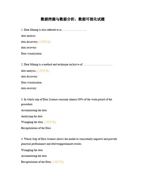
数据挖掘与数据分析,数据可视化试题1. Data Mining is also referred to as ……………………..data analysisdata discovery(正确答案)data recoveryData visualization2. Data Mining is a method and technique inclusive of …………………………. data analysis.(正确答案)data discoveryData visualizationdata recovery3. In which step of Data Science consume Almost 80% of the work period of the procedure.Accumulating the dataAnalyzing the dataWrangling the data(正确答案)Recapitulation of the Data4. Which Step of Data Science allows the model to consistently improve and provide punctual performance and deliverapproximate results.Wrangling the dataAccumulating the dataRecapitulation of the Data(正确答案)Analyzing the data5. Which tool of Data Science is robust machine learning library, which allows the implementation of deep learning ?algorithms. STableauD3.jsApache SparkTensorFlow(正确答案)6. What is the main aim of Data Mining ?to obtain data from a less number of sources and to transform it into a more useful version of itself.to obtain data from a less number of sources and to transform it into a less useful version of itself.to obtain data from a great number of sources and to transform it into a less useful version of itself.to obtain data from a great number of sources and to transform it into a more useful version of itself.(正确答案)7. In which step of data mining the irrelevant patterns are eliminated to avoid cluttering ? Cleaning the data(正确答案)Evaluating the dataConversion of the dataIntegration of data8. Data Science t is mainly used for ………………. purposes. Data mining is mainly used for ……………………. purposes.scientific,business(正确答案)business,scientificscientific,scientificNone9. Pandas ………………... is a one dimensional labeled array capable of holding data of any type (integer, string, float, python objects, etc.).Series(正确答案)FramePanelNone10. How many principal components Pandas DataFrame consists of ?4213(正确答案)11. Important data structure of pandas is/are ___________SeriesData FrameBoth(正确答案)None of the above12. Which of the following command is used to install pandas?pip install pandas(正确答案)install pandaspip pandasNone of the above13. Which of the following function/method help to create Series? series()Series()(正确答案)createSeries()None of the above14. NumPY stands for?Numbering PythonNumber In PythonNumerical Python(正确答案)None Of the above15. Which of the following is not correct sub-packages of SciPy? scipy.integratescipy.source(正确答案)scipy.interpolatescipy.signal16. How to import Constants Package in SciPy?import scipy.constantsfrom scipy.constants(正确答案)import scipy.constants.packagefrom scipy.constants.package17. ………………….. involveslooking at and describing the data set from different angles and then summarizing it ?Data FrameData VisualizationEDA(正确答案)All of the above18. what involves the preparation of data sets for analysis by removing irregularities in the data so that these irregularities do not affect further steps in the process of data analysis and machine learning model building ?Data AnalysisEDA(正确答案)Data FrameNone of the above19. What is not Utility of EDA ?Maximize the insight in the data setDetect outliers and anomaliesVisualization of dataTest underlying assumptions(正确答案)20. what can hamper the further steps in the machine learning model building process If not performed properly ?Recapitulation of the DataAccumulating the dataEDA(正确答案)None of the above21. Which plot for EDA to check the dependency between two variables ? HistogramsScatter plots(正确答案)MapsTime series plots22. What function will tell you the top records in the data set?shapehead(正确答案)showall of the aboce23. what type of data is useful for internal policymaking and business strategy building for an organization ?public dataprivate data(正确答案)bothNone of the above24. The ………… function can “fill in” NA valueswith non-null data ?headfillna(正确答案)shapeall of the above25. If you want to simply exclude the missing values, then what function along with the axis argument will be use?fillnareplacedropna(正确答案)isnull26. Which of the following attribute of DataFrame is used to display data type of each column in DataFrame?DtypesDTypesdtypes(正确答案)datatypes27. Which of the following function is used to load the data from the CSV file into a DataFrame?read.csv()readcsv()read_csv()(正确答案)Read_csv()28. how to Display first row of dataframe ‘DF’ ?print(DF.head(1))print(DF[0 : 1])print(DF.iloc[0 : 1])All of the above(正确答案)29. Spread function is known as ................ in spreadsheets ?pivotunpivot(正确答案)castorder30. ................. extract a subset of rows from a data fram based on logical conditions ? renamefilter(正确答案)setsubset31. We can shift the DataFrame’s index by a certain number of periods usingthe …………. Method ?melt()merge()tail()shift()(正确答案)32. We can join melted DataFrames into one Analytical Base Table using the ……….. function.join()append()merge()(正确答案)truncate()33. What methos is used to concatenate datasets along an axis ?concatenate()concat()(正确答案)add()merge()34. Rows can be …………….. if the number of missing values is insignificant, as thiswould not impact the overall analysis results.deleted(正确答案)updatedaddedall35. There is a specific reason behind the missing value.What stands for Missing not at randomMCARMARMNAR(正确答案)None of the above36. While plotting data, some values of one variable may not lie beyond the expectedrange, but when you plot the data with some other variable, these values may lie far from the expected value.Identify the type of outliers?Univariate outliersMultivariate outliers(正确答案)ManyVariate outlinersNone of the above37. if numeric values are stored as strings, then it would not be possible to calculatemetrics such as mean, median, etc.Then what type of data cleaning exercises you will perform ?Convert incorrect data types:(正确答案)Correct the values that lie beyond the rangeCorrect the values not belonging in the listFix incorrect structure:38. Rows that are not required in the analysis. E.g ifobservations before or after a particular date only are required for analysis.What steps we will do when perform data filering ?Deduplicate Data/Remove duplicateddataFilter rows tokeep only therelevant data.(正确答案)Filter columns Pick columnsrelevant toanalysisBring the datatogether, Groupby required keys,aggregate therest39. you need to…………... the data in order to get what you need for your analysis. searchlengthorderfilter(正确答案)40. Write the output of the following ?>>> import pandas as pd >>> series1 =pd.Series([10,20,30])>>> print(series1)0 101 202 30dtype: int64(正确答案)102030dtype: int640 1 2 dtype: int64None of the above41. What will be output for the following code?import numpy as np a = np.array([1, 2, 3], dtype = complex) print a[[ 1.+0.j, 2.+0.j, 3.+0.j]][ 1.+0.j]Error[ 1.+0.j, 2.+0.j, 3.+0.j](正确答案)42. What will be output for the following code?import numpy as np a =np.array([1,2,3]) print a[[1, 2, 3]][1][1, 2, 3](正确答案)Error43. What will be output for the following code?import numpy as np dt = dt =np.dtype('i4') print dtint32(正确答案)int64int128int1644. What will be output for the following code?import numpy as np dt =np.dtype([('age',np.int8)]) a = np.array([(10,),(20,),(30,)], dtype = dt)print a['age'][[10 20 30]][10 20 30](正确答案)[10]Error45. We can add a new row to a DataFrame using the _____________ methodrloc[ ]iloc[ ]loc[ ](正确答案)None of the above46. Function _____ can be used to drop missing values.fillna()isnull()dropna()(正确答案)delna()47. The function to perform pivoting with dataframes having duplicate values is _____ ? pivot(unique = True)pivot()pivot_table(unique = True)pivot_table()(正确答案)48. A technique, which when performed on a dataframe, rearranges the data from rows and columns in a report form, is called _____ ?summarisingreportinggroupingpivoting(正确答案)49. Normal Distribution is symmetric is about ___________ ?VarianceMean(正确答案)Standard deviationCovariance50. Write a statement to display “Amount” as x-axis label. (consider plt as an alias name of matplotlib.pyplot)bel(“Amount”)plt.xlabel(“Amount”)(正确答案)plt.xlabel(Amount)None of the above51. Fill in the blank in the given code, if we want to plot a line chart for values of list ‘a’ vs values of list ‘b’.a = [1, 2, 3, 4, 5]b = [10, 20, 30, 40, 50]import matplotlib.pyplot as pltplt.plot __________(a, b)(正确答案)(b, a)[a, b]None of the above52. #Loading the datasetimport seaborn as snstips =sns.load_dataset("tips")tips.head()In this code what is tips ?plotdataset name(正确答案)paletteNone of the above53. Visualization can make sense of information by helping to find relationships in the data and support (or disproving) ideas about the dataAnalyzeRelationShip(正确答案)AccessiblePrecise54. In which option provides A detailed data analysis tool that has an easy-to-use tool interface and graphical designoptions for visuals.Jupyter NotebookSisenseTableau DesktopMATLAB(正确答案)55. Consider a bank having thousands of ATMs across China. In every transaction, Many variables are recorded.Which among the following are not fact variables.Transaction charge amountWithdrawal amountAccount balance after withdrawalATM ID(正确答案)56. Which module of matplotlib library is required for plotting of graph?plotmatplotpyplot(正确答案)None of the above57. Write a statement to display “Amount” as x-axis label. (consider plt as an alias name of matplotlib.pyplot)bel(“Amount”)plt.xlabel(“Amount”)(正确答案)plt.xlabel(Amount)None of the above58. What will happen when you pass ‘h’ as as a value to orient parameter of the barplot function?It will make the orientation vertical.It will make the orientation horizontal.(正确答案)It will make line graphNone of the above59. what is the name of the function to display Parameters available are viewed .set_style()axes_style()(正确答案)despine()show_style()60. In stacked barplot, subgroups are displayed as bars on top of each other. How many parameters barplot() functionhave to draw stacked bars?OneTwoNone(正确答案)three61. In Line Chart or Line Plot which parameter is an object determining how to draw the markers for differentlevels of the style variable.?x.yhuemarkers(正确答案)legend62. …………………..similar to Box Plot but with a rotated plot on each side, giving more information about the density estimate on the y axis.Pie ChartLine ChartViolin Chart(正确答案)None63. By default plot() function plots a ________________HistogramBar graphLine chart(正确答案)Pie chart64. ____________ are column-charts, where each column represents a range of values, and the height of a column corresponds to how many values are in that range.Bar graphHistograms(正确答案)Line chartpie chart65. The ________ project builds on top of pandas and matplotlib to provide easy plotting of data.yhatSeaborn(正确答案)VincentPychart66. A palette means a ________.. surface on which a painter arranges and mixed paints. circlerectangularflat(正确答案)all67. The default theme of the plotwill be ________?Darkgrid(正确答案)WhitegridDarkTicks68. Outliers should be treated after investigating data and drawing insights from a dataset.在调查数据并从数据集中得出见解后,应对异常值进行处理。

可视化方法与技术计算机系统在各领域中的广泛应用导致海量数据的产生,数据处理能力的滞后迫切需要研究和开发新的信息处理技术和方法。
基于此,海量、异构、时变、多维数据的可视化表示和分析在各领域中日益受到重视并得到越来越广泛的应用.一、可视化概述测量的自动化、网络传输过程的数字化和大量的计算机仿真产生了海量数据,超出了人类分析处理的能力.可视化提供了解决这种问题的一种新工具。
一般意义下的可视化定义为:可视化是一种使复杂信息能够容易和快速被人理解的手段,是一种聚焦在信息重要特征的信息压缩语言,是可以放大人类感知的图形化表示方法。
可视化就是把数据、信息和知识转化为可视的表示形式并获得对数据更深层次认识的过程。
可视化作为一种可以放大人类感知的数据、信息、知识的表示方法,日益受到重视并得到越来越广泛的应用。
可视化可以应用到简单问题,也可以应用到复杂系统状态表示,从可视化的表示中人们可以发现新的线索、新的关联、新的结构、新的知识,促进人机系统的结合,促进科学决策。
可视化充分利用计算机图形学、图像处理、用户界面、人机交互等技术,形象、直观地显示科学计算的中间结果和最终结果并进行交互处理。
可视化技术以人们惯于接受的表格、图形、图像等方法并辅以信息处理技术将客观事物及其内在的联系进行表现,可视化结果便于人们记忆和理解。
可视化为人类与计算机这两个信息处理系统之间提供了一个接口。
可视化对于信息的处理和表达方式有其它方式无法取代的优势,其特点可总结为可视性、交互性和多维性。
二、可视化技术目前,可视化技术包括数据可视化、科学计算可视化、信息可视化和知识可视化等,这些概念及应用存在着区别、交叉和联系.(一)数据可视化数据可视化技术指的是运用计算机图形学和图像处理技术,将数据转换为图形或图像在屏幕上显示出来,并进行交互处理的理论、方法和技术。
数据可视化的重点是将多维数据在二维或三维空间内显示,这对初步的数据分类理解是有意义的。
针对于此,产生了许多数据可视化的技术,大体分为散点矩阵法、投影矩阵法、平行坐标法、面向象素的可视化技术、层次技术、动态技术、图标表示技术、直方图法及一些几何学技术等等。
GIS的主要研究领域与发展趋势GIS(地理信息系统)是一种将地理空间数据与属性数据相结合的计算机技术,用于收集、管理、分析和展示地理信息的工具。
随着技术的不断发展,GIS的研究领域也在不断扩展,并呈现出一些明显的发展趋势。
1.空间数据处理与管理:这是GIS的基础研究领域,包括空间数据的采集、存储、整理和更新等。
随着遥感技术和全球导航卫星系统的发展,空间数据的获取和处理能力不断增强,对于大规模、多维、高分辨率数据的处理和管理成为研究的重点。
2.空间分析与模型:空间分析是GIS的核心功能之一,包括空间关系分析、空间模式分析、空间插值分析等。
这些分析方法可以帮助研究人员在地理空间中找到隐藏的关联性和规律,并构建空间模型进行预测和决策支持。
3.空间数据挖掘与可视化:空间数据挖掘是对空间数据进行深入挖掘和发现的过程,它包括空间聚类、时空模式挖掘、地理关联规则挖掘等。
可视化则是将空间数据以图形、动画等方式直观地展示出来,帮助用户更好地理解和使用地理信息。
4.空间数据质量与精度:空间数据的质量对于GIS应用的准确性和可靠性至关重要。
研究者致力于开发出新的方法和技术,提高数据的精度、一致性和完整性,以确保GIS分析结果的正确性和可信度。
5.GIS与网络空间:随着互联网的普及和发展,GIS与网络空间的结合成为研究的新方向。
这包括基于云计算的GIS服务、互联网GIS应用、移动GIS等,旨在提高GIS系统的可访问性、可扩展性和共享性。
GIS的发展趋势如下:2.面向大数据的GIS技术:随着大数据时代的来临,GIS也面临着应对大规模、多维度、高速度数据处理的挑战。
研究者正在探索新的算法和技术,以推动GIS在大数据环境下的应用和发展。
3.移动GIS的普及与应用:移动设备的普及和发展为移动GIS的应用提供了巨大的机会。
研究者正在致力于开发移动GIS应用软件和技术,使用户可以实时获取和使用地理信息。
4.基于云计算的GIS服务:云计算技术的发展为GIS的服务模式提供了新的空间。

智慧城市中的空间数据挖掘与可视化随着城市规模和人口的不断增长,城市管理面临着越来越多的挑战。
智慧城市已经成为了解决城市问题的一个重要手段。
智慧城市的基础是数据,而其中包括了大量的空间数据。
空间数据可以帮助城市管理者更好地理解城市的运行和发展,从而更加精确地进行决策。
本文将探讨智慧城市中的空间数据挖掘与可视化。
一、什么是智慧城市智慧城市是基于信息化和智能化技术,以城市为载体,通过海量数据的收集、处理、分析和共享,实现城市的智能化、开放化和共享化。
智慧城市的建设不仅需要技术的支持,还需要政府、企业和居民的积极参与,形成整个城市共治的格局。
二、智慧城市中的空间数据空间数据是智慧城市建设过程中不可或缺的一部分。
空间数据的收集可以通过各种传感器获得,例如全球定位系统(GPS)、卫星图像、地面测量仪器等。
利用空间数据可以实现城市的三维建模、交通热力图的绘制、环境监测等,这些都是城市管理所必需的信息。
三、空间数据挖掘空间数据挖掘是指对空间数据进行分析获取信息的过程。
空间数据挖掘的目的是通过数据挖掘算法将数据转化为知识,发现数据隐藏的特点和规律。
常用的空间数据挖掘方法有聚类分析、关联分析、分类分析和时间序列分析等。
这些方法可以通过对空间数据的处理,提供对城市管理更深入的理解和更准确的数据支持。
四、空间数据可视化空间数据可视化是实现对空间数据展示的一种方法。
通过可视化可以直观地观察和理解空间数据,发现数据中隐藏的规律。
常用的空间数据可视化方法有地图展示、三维可视化和热力图等。
这些方法可以帮助城市管理者更好地理解城市的运行、规划城市发展、提升城市形象等。
五、空间数据挖掘与可视化的应用空间数据挖掘与可视化的应用已经被广泛地应用于智慧城市建设。
例如通过交通热力图可以发现城市繁忙的交通拥堵情况,确定交通管制的方案;通过三维城市建模可以更好地展现城市的面貌,规划城市发展。
六、结论智慧城市建设离不开空间数据挖掘和可视化。
通过对空间数据的挖掘和可视化可以更好地理解城市的运行和发展,加强城市管理和规划。

空间大数据分析技术研究与应用分析一、引言随着互联网的发展和计算机技术的飞速进步,大数据分析技术已经被广泛应用于各行各业。
在这个发展的大潮中,空间大数据分析技术逐渐受到了人们的关注和重视。
空间大数据分析技术是将空间数据与大数据相结合,采用各种统计学、计算机科学、地理信息系统等技术手段,对大规模的空间数据进行处理和分析,以揭示其内在规律和特征。
本文将探讨空间大数据分析技术的研究现状和应用分析。
二、空间大数据分析技术的研究现状空间大数据分析技术经过了多年的发展,取得了一系列重要的研究成果。
以下是一些主要的研究成果:1、空间数据挖掘技术空间数据挖掘技术是一种大数据分析技术,它是将空间数据与数据挖掘相结合,通过各种算法对空间数据进行分析和挖掘,以发现数据中的隐藏规律和关联关系。
例如,通过对交通流量数据进行聚类分析,可以将城市中的交通拥堵点进行识别和预测。
2、空间数据可视化技术空间数据可视化技术是将空间数据以可视化的形式呈现,帮助用户更好地理解和分析空间数据。
例如,通过地图软件将房价数据以热力图的形式展示出来,可以直观地看出不同地区的房价分布情况。
3、空间数据流分析技术空间数据流分析技术是一种实时处理空间数据的技术,它可以对空间数据进行实时分析和处理,以满足实时决策的需要。
例如,在城市交通领域应用空间数据流分析技术,可以实时监测和优化城市路网的交通情况。
三、空间大数据分析技术的应用分析空间大数据分析技术已经在众多领域得到了广泛应用,以下是一些主要的应用场景:1、城市交通随着城市化程度的不断提高,城市交通问题变得越来越突出。
在这种情况下,利用空间大数据分析技术可以优化城市交通系统,提高路网计算能力和减少交通拥堵。
例如,美国芝加哥交通管理局采用空间大数据分析技术对城市交通进行实时监测和分析,以优化交通状况,提高交通效率。
2、生态环保空间大数据分析技术在生态环保领域的应用也非常广泛。
以地表覆盖分析为例,可以通过分析卫星图像、无人机图像和地形数据等空间数据,建立地表覆盖分类模型,进行水土保持、森林保护和生态修复等工作。
基于深度学习的地理空间数据分析与可视化研究地理空间数据分析与可视化是一门涉及地理信息科学、计算机科学和人工智能的交叉学科。
随着深度学习技术的快速发展,基于深度学习的地理空间数据分析与可视化研究逐渐成为研究热点。
本文将从理论和实践两个方面探讨基于深度学习的地理空间数据分析与可视化研究的相关进展和应用。
一、基于深度学习的地理空间数据分析1. 深度学习在地理空间数据分类和识别中的应用深度学习算法,如卷积神经网络(CNN)和循环神经网络(RNN)等,具有强大的特征提取和模式识别能力,因此被广泛应用于地理空间数据的分类和识别任务。
通过在训练集上训练深度学习模型,可以实现对地理空间数据的自动分类和识别,例如卫星影像中的土地覆盖类型识别、建筑物的识别和道路网络的提取等。
2. 深度学习在地理空间数据预测和模型中的应用地理空间数据的预测和模型构建是地理空间分析的重要任务。
基于深度学习的方法可以通过对历史数据的学习,实现对未来地理空间数据的预测。
例如,可以利用深度学习算法对气象数据进行建模,预测未来的天气情况;可以基于深度学习模型对交通流量数据进行预测,优化交通规划和路线选择。
3. 深度学习在地理空间数据挖掘和可视化中的应用深度学习技术可以用于地理空间数据的挖掘和可视化,帮助我们发现隐藏在数据中的规律和关联。
通过深度学习算法对地理空间数据进行聚类和关联分析,可以揭示地理空间数据中的模式和趋势。
此外,利用深度学习和可视化技术结合,可以将复杂的地理空间数据转化为直观、易于理解的可视化图形,更好地展示地理信息和分析结果。
二、基于深度学习的地理空间数据可视化研究1. 可视化方法和技术基于深度学习的地理空间数据可视化需要结合可视化方法和技术,将抽象的地理空间数据转化为视觉化的图像。
传统的可视化方法,如2D和3D可视化、符号化和着色等,可以与深度学习相结合,提供高质量的地理空间数据可视化效果。
此外,虚拟现实(VR)和增强现实(AR)等新技术也为地理空间数据可视化带来了新的可能性。
第3期2020年1月No.3January ,2020时空大数据挖掘分析及可视化技术研究与系统设计江苏科技信息Jiangsu Science &Technology Information曹全龙,石善球(江苏省基础地理信息中心,江苏南京210013)作者简介:曹全龙(1980—),男,江苏常州人,高级工程师,硕士;研究方向:GIS 应用与开发。
摘要:大数据正日益改变人类的工作、生活和思维方式,当今社会80%以上的数据都与时空相关。
无论是政府主导的智慧城市建设、土地利用规划、应急管理,还是企业的网点选址、营销策划等行为,都离不开时空大数据的支撑。
如何对时空大数据进行分析挖掘,并实现大数据的可视化表现成为社会普遍关心和重点研究的内容。
文章分析了时空大数据分析挖掘及可视化的发展现状及存在问题,研究了主要关键技术,并对系统进行了总体设计。
关键词:时空大数据;分析挖掘;数据可视化;系统设计中图分类号:P2文献标志码:A 0引言以大数据、物联网、云计算等为代表的信息技术迅猛发展,引领着新一轮科技革命和产业变革,正在日益改变人们的生产生活方式、经济运行机制和社会治理模式。
大数据既是大机遇,也是大红利。
国家已经把大数据发展上升为国家战略,大数据对经济建设、行业发展、政府宏观管理等各方面都起到重要的基础支撑作用。
随着智慧城市的发展,很多城市都在开展时空大数据平台建设,通过建立基础时空框架,提供丰富多样的时空数据服务,满足城市运行和管理的自动化、智能化需求。
时空大数据主要包含基础地理数据、遥感影像数据、行业专题数据、互联网大数据、物联网及GPS 实时数据等,数据量庞大,种类繁多,格式各异。
为了更好地利用数据服务行业发展和政府管理,充分发挥时空大数据的信息支撑作用,迫切需要解决数据的挖掘提取、整合分析以及可视化表达等问题。
1发展现状及存在问题时空大数据挖掘通过数据表达、信息组织与知识发现等手段发现数据深层次的特征和规律,主要包含时空模式挖掘、时空聚类、时空分类、时空异常检测等内容[1]。
基于WebGIS的地理空间数据分析与可视化技术研究WebGIS(Web Geographic Information System)是一种基于Web平台的地理信息系统,是利用互联网技术,将地理信息与网络技术相结合,实现地理数据的存储、查询、分析和可视化展示的一种技术手段。
本文将对基于WebGIS的地理空间数据分析与可视化技术进行研究和探讨。
一、地理空间数据分析技术研究:地理空间数据分析是利用地理信息系统,对地理空间数据进行挖掘、分析和模型构建的过程。
基于WebGIS的地理空间数据分析技术研究主要包括以下几个方面:1. 空间数据挖掘:空间数据挖掘是从大量的地理空间数据中发现隐藏在其中的有价值的知识和模式的过程。
如何有效地对地理空间数据进行分类、聚类、关联规则挖掘等,是地理空间数据分析的重要研究方向。
2. 空间数据模型和分析方法:建立合适的空间数据模型和分析方法,是进行地理空间数据分析的基础。
例如,空间网络模型、空间插值方法、空间多目标决策模型等都是研究的热点。
3. 面向WebGIS的空间数据分析算法:在WebGIS环境下,由于数据量大、实时性要求高等特点,需要研究面向WebGIS的高效算法。
例如,基于流数据的空间数据挖掘算法、面向WebGIS的实时空间查询算法等。
二、地理空间数据可视化技术研究:地理空间数据可视化是将地理信息以图形化的方式展示出来,让使用者更直观地理解和分析地理空间数据的过程。
基于WebGIS的地理空间数据可视化技术研究主要包括以下几个方面:1. 地图设计与制图技术:地图设计与制图技术是地理空间数据可视化的基础。
通过研究如何设计合理的地图符号、优化地图颜色、制作专题地图等技术,可以提高地理空间数据的可视化效果和传达信息的能力。
2. 三维地理可视化技术:三维地理可视化技术可以将地理空间数据以立体的方式呈现,增强用户的空间感知能力。
例如,基于WebGL等技术的三维地理可视化技术,可以实现地球模型的交互式浏览和动态可视化效果。


地理信息科学中的空间数据分析与可视化技术地理信息科学(Geographic Information Science,简称GIS)是一门跨学科的研究领域,涵盖地理学、计算机科学、数学、地质学、环境科学等多个学科。
它将地理空间信息与计算机技术相结合,以构建空间数据存储、处理、分析、可视化和应用平台,为决策制定、资源管理、环境保护、城市规划等领域提供支持。
空间数据分析与可视化技术是GIS的核心内容,本文将对其进行深入探讨。
一、空间数据分析技术空间数据分析技术是GIS的重要组成部分,主要包括数据预处理、空间关系分析、空间模型构建、空间数据挖掘等多个方面。
在实际应用中,空间数据分析技术可用于资源、环境、灾害、经济等多个领域。
1. 数据预处理数据预处理是空间数据分析的第一步,主要包括数据清洗、数据转换、数据集成等几个方面。
其中,数据清洗是指对采集数据进行质量控制和纠错,以减少分析中的误差和偏差;数据转换是指将不同格式的空间数据转换为统一的数据格式和数据模型,以方便分析和可视化;数据集成是指将多源数据集成到一起,以提高数据的完整性和准确性。
2. 空间关系分析空间关系分析是GIS的核心内容之一,主要包括空间接近度分析、点线面关系分析、路径分析等几个方面。
其中,空间接近度分析用于确定地理空间相邻点之间的距离和方向关系,以评估空间接近度的程度;点线面关系分析用于确定点、线、面对象之间的拓扑关系和覆盖关系,以帮助用户了解空间实体的位置和分布;路径分析用于确定两个地点之间的最短路径、最优路径、多路径等,以计算出行距离和时间。
3. 空间模型构建空间模型构建是GIS的另一个核心内容,主要包括空间数据模型、空间分析模型、空间决策模型等几个方面。
其中,空间数据模型用于描述和管理地理空间实体和属性关系的数据结构,以进行数据的查询和更新;空间分析模型用于描述和计算地理空间实体之间的拓扑关系和度量关系,以进行数据的统计和分析;空间决策模型用于描述和辅助空间决策的过程,以进行决策的评估和优化。
数据分析与可视化在当今信息化时代,数据成为了我们生活中不可或缺的一部分。
随着互联网的发展和智能设备的普及,我们每天都在产生大量的数据。
然而,这些数据对于我们来说并不是一目了然的,因此,数据分析与可视化成为了一种必不可少的技能和工具。
一、数据分析数据分析是指通过收集、整理和处理数据,以发现其中的规律、趋势和未知信息的过程。
它利用统计学、机器学习和其他数据挖掘技术来对数据进行解读和分析。
数据分析的过程通常包括以下几个步骤:1. 数据收集:首先要确定需要分析的数据范围和类型,并收集这些数据。
数据可以来自各种渠道,包括数据库、传感器、网络和用户反馈等。
2. 数据清洗:数据在收集过程中往往会存在一些错误、缺失或异常值,因此需要进行数据清洗。
清洗数据可以通过删除重复值、处理缺失值和校验数据的正确性等步骤来实现。
3. 数据探索:在数据清洗完成后,可以进行数据的探索性分析。
探索性分析可以帮助我们了解数据的分布、关联性和异常情况,为后续的分析提供基础。
4. 数据建模:在数据探索的基础上,可以选择合适的模型进行数据建模。
数据建模可以通过统计学方法、机器学习算法或深度学习技术来实现,以获取准确的预测结果或者发现隐藏的模式。
二、可视化工具数据分析的结果并不仅仅是数字或图表,而是需要以一种可视化的方式来展现,以便更好地传达分析的结果和见解。
下面介绍几种常用的数据可视化工具:1. 表格:最简单直观的数据可视化方式就是通过表格来展示数据。
表格可以清晰地呈现各种数据指标和细节,适用于简单的数据展示和比较。
2. 图表:图表是更常用的数据可视化形式之一,可以通过直方图、折线图、饼图等形式展示数据。
不同类型的图表适用于不同的数据类型和分析目的,能够更好地展示数据的趋势和关联性。
3. 地图:地图可视化是一种将数据与地理空间信息相结合的方式。
通过将数据在地图上展示,可以更直观地发现地理位置与数据之间的关系,例如人口分布、销售区域等。
4. 仪表盘:仪表盘是一种通过多种图表和指标来展示数据的集合。
空间数据挖掘主要方法数据分析微信公众号datadw——关注你想了解的,分享你需要的。
1.空间分析方法利用GIS的各种空间分析模型和空间操作对GIS数据库中的数据进行深加工,从而产生新的信息和知识。
常用的空间分 析方法有综合属性数据分析、拓扑分析、缓冲区分析、距离分析、叠置分析、地形分析、趋势面分析、预测分析等,可发现目标在空间上的相连、相邻和共生等关联规则,或发现目标之间的最短路径、最优路径等辅助决策知识。
2.统计分析方法统计分析一直是分析空间数据的常用方法,着重于空间物体和现象的非空间特性分析。
统计方法有较强的理论基础,拥有大量成熟的算法。
统计方法难以处理字符型数据,需要有领域知识和统计知识,一般由具有统计经验的领域专家来完成。
3.归纳学习方法归纳学习方法是从大量的经验数据中归纳制取一般的规则和模式,其大部分算法来源于机器学习领域,归纳学习的算法很 多,如Michaski等的 AQ11,AQ15,洪家荣等的AE1,AE9,Hunt的CLS,Quinlan的ID3,C5.0等,其中最著名的是Quinlan提出的C5.0决策树算法。
4.聚类与分类方法聚类和分类方法按一定的距离或相似性系统将数据分成一系列相互区分的组。
常用的经典聚类方法有 Kmean,Kmeriod,ISO DATA 等。
分类和聚类都是对目标进行空间划分,划分的标准是类内差别最小,类间差别最大。
分类和聚类的区别在于分类事先知道类别数和种类的典型特征,而聚类则事先不知道。
5.探测性的数据分析方法李德仁、邸凯昌等提出了探测性的数据分析(简称EDA)。
EDA采用动态统计图形和动态链接窗口技术将数据及统计特 征显示出来,可发现数据中非直观 的数据特征及异常数据。
EDA与空间分析相结合,构成探测性空间分析(exploratory spatial analysis,简称ESA)。
EDA和ESA技术在数据挖掘中用于选取与问题领域相关的数据子集,并可初步发现隐含在数据中的某些特征和规律。
空间数据建模及其分析方法研究随着科技的不断进步和人类社会的不断发展,空间数据的应用在各行各业中越来越普及。
但是,想要对空间数据进行分析,首先需要将其进行建模。
因此,本文将探讨空间数据建模及其分析方法的研究。
一、空间数据建模的概念空间数据建模,是指将空间数据通过一种适当的方法,将其转换为数学模型或几何模型,以利于对数据进行分析、处理和管理的过程。
空间数据建模的基本目的是将地理空间信息转换为计算机可处理的形式,从而实现对空间数据的高效管理和分析。
空间数据建模主要包括模型建立和模型应用两个部分。
模型建立是指通过数学方法将现实中的空间数据抽象为模型,以便于进行计算机操作和处理。
而模型应用是指在建立好的模型上进行分析、处理和可视化等操作,以了解现实世界中的地理空间信息。
在空间数据建模的过程中,需要考虑的因素主要包括数据类型、数据来源、数据格式、空间参照系统和数据精度等。
在空间数据建模的过程中,一般采用矢量模型和栅格模型两种方法进行。
二、矢量模型矢量模型是将空间数据以点、线、面等基本几何对象的形式进行表达的方法。
矢量模型适用于对空间数据进行精细化处理和表达,具有较高的精度和数据质量。
矢量模型主要由三类要素组成:1. 点要素:矢量模型中最基本的要素,可以表示出一些空间位置或者一个地物的特定点,如建筑物、水源等。
2. 线要素:线要素由点要素连接而成,可以表达一些空间关系和空间连通性等,如道路、河流等。
3. 面要素:面要素是由线和点组成的,代表了地物的范围和空间形态,如植被分布、土地利用等。
矢量模型具有直观、可操作性强等优点,但对数据精度和数据量的要求较高,同时对数据的预处理和后处理算法也要求较高。
三、栅格模型栅格模型是将空间数据直接转换为一个由网格单元组成的二维或三维矩阵,每个网格单元表示一个离散的地物或其他特定的空间属性。
栅格模型是一种比较简单的空间数据建模方法,具有较高的处理速度和数据存储效率。
栅格模型主要由三个要素组成:1. 栅格单元:栅格模型的最基本要素,代表地物或其他具有特定属性的空间单元,如植被类型、土地利用类型等。
三维城市规划辅助决策支持系统的设计与实现的开题报告一、研究背景随着城市化进程的不断加快,城市规划和城市管理越来越复杂。
而传统的城市规划模式往往是基于单一视角进行决策,难以获取全面的城市信息,容易出现盲点和瑕疵,导致规划结果难以达到预期目标。
因此,发展一种能够支持多维度、全面、系统地分析城市规划问题的辅助决策支持系统具有重要的意义。
二、研究目标和意义本研究旨在通过软件技术、空间分析技术和数据可视化技术,创建一个三维城市规划辅助决策支持系统,该系统具有以下目标和意义:1、提高决策的科学性。
多维度、全面的数据和模型分析将帮助决策者全面把握城市规划问题,更准确地把握未来趋势,提高规划决策的科学性和合理性。
2、增强决策的可视性。
通过可视化技术将城市规划问题呈现在三维空间中,可以加深决策者对规划效果的认知和理解。
3、提高决策效率。
系统可以对城市规划问题进行多维度、实时分析,辅助决策者快速制定科学的规划方案,提高决策效率。
三、研究内容和技术路线本系统的设计将从以下方面展开:1、系统需求分析和规划模型构建。
通过对城市规划问题的分析和整理,建立多指标评价的城市规划模型,为系统的设计提供基础。
2、算法优化和模型调整。
对规划模型进行优化和调整,保证模型能够更准确地反映城市规划问题的实际情况。
3、空间数据挖掘和可视化。
利用现有的空间数据、地图数据和卫星遥感数据,通过数据挖掘技术,为决策支持系统提供空间数据,并将获取的数据进行可视化展示。
4、系统实现和开发。
基于以上研究成果,开发并实现三维城市规划辅助决策支持系统。
系统将包括数据管理、模型计算、可视化展示和决策支持等多个模块,以实现一个完整的辅助决策支持系统。
四、研究进展和计划目前,本研究已完成对城市规划问题的整理和多指标评价模型的构建。
下一步,将进行算法优化和模型调整,以提高模型的准确性和全面性。
同时,还将收集和整理大量的空间数据和地图数据,通过空间数据挖掘和可视化技术,为系统提供足够的数据支持。
地理信息系统中的空间数据挖掘与分析研究地理信息系统(Geographic Information System,简称GIS)是一种集数据管理、数据分析和数据可视化等功能于一体的技术系统,广泛应用于城市规划、环境保护、资源管理、灾害防治等领域。
其中,空间数据挖掘与分析是GIS中的重要研究内容之一。
本文将探讨地理信息系统中空间数据挖掘与分析的研究现状、方法和应用。
首先,我们需要了解空间数据挖掘与分析的概念。
空间数据挖掘是从地理信息系统中的空间数据中提取有价值的知识,并发现其中的模式、规律和趋势。
与传统数据挖掘相比,空间数据挖掘不仅考虑数据的属性特征,还考虑数据的地理位置关系。
空间数据分析则是对空间数据进行统计、建模、推断和演绎等分析过程,以揭示地理现象的本质和规律。
在进行空间数据挖掘与分析时,研究人员通常采用多种方法和技术。
其中,最常用的方法之一是聚类分析。
聚类分析可以将具有相似地理特征的数据对象划分为不同的群组,并发现这些群组之间的关系。
这对于城市规划、社区划分等领域具有重要意义。
另一种常见的方法是空间关联分析。
空间关联分析可以揭示地理位置之间的关联关系,例如地理现象的空间延伸、空间交互等。
通过空间关联分析,我们可以发现某个地理现象是否与其他地理现象有关,并进一步研究它们之间的相互影响。
此外,GIS中的空间数据挖掘与分析还包括地理空间模型的构建和预测。
通过建立合适的模型,我们可以对地理现象进行预测,并为决策提供科学依据。
例如,通过构建交通流量预测模型,可以为交通管理部门提供准确的交通规划和调度方案。
在实际应用中,空间数据挖掘与分析在多个领域有着广泛的应用。
首先,它在城市规划中起着重要作用。
通过对城市空间数据的挖掘与分析,可以了解城市内不同区域的人口分布、交通拥堵情况等,为城市规划提供科学依据。
其次,空间数据挖掘与分析在环境保护领域也发挥着重要作用。
通过分析环境监测数据和地理空间数据,可以揭示污染源分布、环境质量变化趋势等信息,为环境监测和治理提供支持。