海河流域湿地格局变化分析
- 格式:pdf
- 大小:2.60 MB
- 文档页数:23
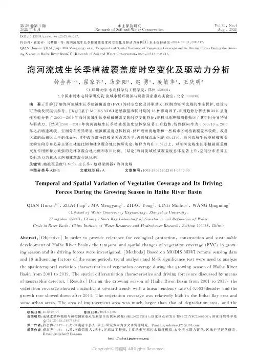
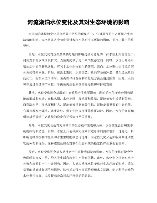
第30卷第4期2023年8月水土保持研究R e s e a r c ho f S o i l a n d W a t e rC o n s e r v a t i o nV o l .30,N o .4A u g.,2023收稿日期:2022-06-07 修回日期:2022-07-06资助项目:流域水循环模拟与调控国家重点实验室自由探索课题(S K L 2022T S 01);国家重点研发计划(2021Y F C 3200200);国家自然科学基金(52025093,51979284) 第一作者:钤会冉(1997 ),女,河南清丰县人,硕士,研究方向为水文水资源研究㊂E -m a i l :qi a n h u i r a n 123@163.c o m 通信作者:翟家齐(1984 ),男,河南信阳人,博士,正高级工程师,主要从事平原区水循环模拟㊁农业节水潜力评估㊁区域干旱评估研究㊂E -m a i l :j i a qi z h a i @163.c o m h t t p :ʊs t b c y j .p a p e r o n c e .o r gD O I :10.13869/j.c n k i .r s w c .2023.04.037.钤会冉,翟家齐,马梦阳,等.海河流域生长季植被覆盖度时空变化及驱动力分析[J ].水土保持研究,2023,30(4):309-317.Q I A N H u i r a n ,Z H A I J i a q i ,MA M e n g y a n g ,e t a l .T e m p o r a l a n d S p a t i a l V a r i a t i o n o fV e g e t a t i o nC o v e r a g e a n d I t sD r i v i n g F o r c e sD u r i n gt h eG r o w -i n g Se a s o n i nH a i h eR i v e rB a s i n [J ].R e s e a r c hof S o i l a n d W a t e rC o n s e r v a t i o n ,2023,30(4):309-317.海河流域生长季植被覆盖度时空变化及驱动力分析钤会冉1,2,翟家齐2,马梦阳2,赵勇2,凌敏华1,王庆明2(1.郑州大学水利科学与工程学院,郑州450001;2.中国水利水电科学研究院流域水循环模拟与调控国家重点实验室,北京100038)摘 要:[目的]了解海河流域生长季植被覆盖度(F V C )的时空变化及其驱动力,以期为海河流域的生态保护㊁建设与可持续发展提供参考㊂[方法]基于MO D I SN D V I 遥感数据和同时期的18种影响因子,采用趋势分析法和M -K 显著性检验分析了2001 2019年海河流域生长季植被覆盖度的时空变化特征;并利用地理探测器探讨了其空间分异特征与驱动力㊂[结果]2001 2019年海河流域生长季植被覆盖度总体呈显著上升趋势,线性倾向率为0.063/10a ,2011年之后增速减缓㊂空间分布差异明显,植被覆盖度总体较高,仅环渤海湾地带和一些城市区域植被覆盖率较低㊂改善区域的面积远大于退化面积,其中改善部分以极显著改善为主,占流域总面积的60.42%㊂海河流域生长季植被覆盖度的空间分布差异主要由林地比例和林草混合地比例所决定,解释力均在30%以上㊂对海河流域生长季植被覆盖度交互作用解释力最强的是林草混合地比例和农田比例㊂[结论]海河流域植被覆盖度总体显著上升,空间分布差异主要驱动力为林地比例和林草混合地比例㊂关键词:植被覆盖度(F V C );生长季;地理探测器;海河流域中图分类号:Q 948 文献标识码:A 文章编号:1005-3409(2023)04-0309-09T e m p o r a l a n dS p a t i a lV a r i a t i o no fV e g e t a t i o nC o v e r a g e a n d I t sD r i v i n gF o r c e sD u r i n g t h eG r o w i n g Se a s o n i nH a i h eR i v e rB a s i n Q I A N H u i r a n 1,2,Z H A I J i a q i 2,MA M e n g y a n g 2,Z H A O Y o n g 2,L I N G M i n h u a 1,WA N G Q i n g m i n g2(1.S c h o o l o f W a t e rC o n s e r v a n c y E n g i n e e r i n g ,Z h e n g z h o uU n i v e r s i t y ,Z h e n g z h o u 450001,C h i n a ;2.S t a t eK e y L a b o r a t o r y o f S i m u l a t i o na n dR e g u l a t i o no f Wa t e r C y c l e i nR i v e rB a s i n ,C h i n aI n s t i t u t e o f W a t e rR e s o u r c e s a n d H y d r o p o w e rR e s e a r c h ,B e i j i n g 100038,C h i n a )A b s t r a c t :[O b j e c t i v e ]I no r d e rt o p r o v i d er e f e r e n c ef o re c o l o gi c a l p r o t e c t i o n ,c o n s t r u c t i o na n ds u s t a i n a b l e d e v e l o p m e n t o fH a i h eR i v e rB a s i n ,t h e t e m p o r a l a n d s p a t i a l c h a n g e s o f v e g e t a t i o n c o v e r a ge (F V C )i n g r o w -i n g s e a s o na n d i t s d r i v i n gf o r c e sw e r e i n v e s t ig a t e d .[M e th o d s ]B a s e do n MO D I SN D V I r e m o t e s e n si n g da t a a n d 18i n f l u e n c i n g f a c t o r s o f t h e s a m e p e r i o d ,t r e n d a n a l y s i s a n d M -Ks i g n i f i c a n c e t e s tw e r eu s e d t oa n a l yz e t h e s p a t i o t e m p o r a l v a r i a t i o n c h a r a c t e r i s t i c s o f v e g e t a t i o n c o v e r a g e d u r i n g t h e g r o w i n g s e a s o no fH a i h eR i v e r B a s i n f r o m2001t o 2019.T h e s p a t i a l d i f f e r e n t i a t i o n c h a r a c t e r i s t i c s a n dd r i v i n g f o r c e s a r e d i s c u s s e db y me a n s ofg e o g r a phi c d e t e c t o r .[R e s u l t s ]D u r i n g t h e g r o w i n g s e a s o no fH a i h eR i v e rB a s i nf r o m2001t o2019,t h e v e g e t a t i o n c o v e r a g e s h o w e d a s i g n i f i c a n t u p w a r d t r e n d ,w i t ha l i n e a r t e n d e n c y ra t e o f 0.063/d e c a d e ,a n d t h e g r o w t h r a t e s l o w e dd o w na f t e r 2011.T h ev e g e t a t i o nc o v e r a g ew a s r e l a t i v e l y h i g h i n t h eB o h a i B a y ar e aa n d s o m eu r b a na r e a s .T h ea r e ao f i m p r o v e m e n ta r e aw a s m u c hl a r g e r t h a nt h a to fd e gr a d a t i o na r e a ,a n dt h e Copyright ©博看网. All Rights Reserved.i m p r o v e m e n t p a r tw a s d o m i n a t e db y e x t r e m e l y s i g n i f i c a n t i m p r o v e m e n t,a c c o u n t i n g f o r60.42%o f t h e t o t a l b a s i na r e a.T h e s p a t i a l v a r i a t i o no f v e g e t a t i o n c o v e r a g e i n H a i h eR i v e rB a s i nd u r i n g t h e g r o w i n g s e a s o nw a s m a i n l y d e t e r m i n e db y t h e p r o p o r t i o no f f o r e s t l a n da n dt h e p r o p o r t i o no fm i x e df o r e s t-g r a s s l a n d,a n dt h e e x p l a n a t o r yp o w e rw a sm o r e t h a n30%.T h e s t r o n g e s t e x p l a n a t i o n f o r t h e i n t e r a c t i o no f v e g e t a t i o nc o v e r a g e i nH a i h eR i v e rB a s i nd u r i n g t h e g r o w i n g s e a s o nw a s t h e r a t i oo fm i x e d f o r e s t a n d g r a s s l a n d a n d t h e r a t i oo f f a r m l a n d.[C o n c l u s i o n]O v e r a l lv e g e t a t i o nc o v e r a g e i n c r e a s e ds i g n i f i c a n t l y i n H a i h eR i v e rB a s i n,a n dt h e m a i nd r i v i n g f o r c ew a s t h e p r o p o r t i o no f f o r e s t l a n d a n d t h e p r o p o r t i o no fm i x e d f o r e s t a n d g r a s s l a n d. K e y w o r d s:f r a c t i o n a l v e g e t a t i o n c o v e r a g e(F V C);g r o w i n g s e a s o n;g e o g r a p h i c a l d e t e c t o r;H a i h eR i v e rB a s i n植被作为陆地生态系统中一个重要的组成部分,在陆地生态系统物质循环㊁能量流动㊁信息传递等方面起到了重要的枢纽作用[1],既能促进地球生态系统平衡㊁水循环㊁气候变化[2-3],还可以用来监测生态环境变化[4]㊂植被覆盖度(f r a c t i o n a l v e g e t a t i o n c o v e r a g e,F V C)指植被(包括叶㊁茎㊁枝)在地面的垂直投影面积占观测区总面积的百分比[5],其变化能够直接或间接改变陆地地表下垫面属性,进而对气候调节㊁水土保持以及生态系统的稳定性等产生影响[6]㊂因此,开展流域尺度植被覆盖变化研究以及揭示其驱动力机制,有利于深刻认识陆地生态系统内部的相互作用,对进一步掌握生态系统恢复成效具有极大意义[7]㊂目前,国内外学者深入研究了不同区域尺度的植被覆盖时空变化规律,主要集中于海河流域㊁黄土高原地区等植被变化显著的区域[8],多年来一直是生态环境等领域研究的热点㊂对于植被覆盖度时空变化驱动力的研究主要运用多元线性回归分析㊁相关性分析等传统数学统计方法㊂为弥补仅把气温㊁降水等气候因子作为驱动因素来进行归因分析的片面性,国内外学者先后提出了残差趋势法[9]㊁回归模型法[10]㊁基于生物物理过程的模型方法[11]和地理探测器法[12]等,来定量分解气温㊁降水等自然因素和人类活动强度等人为因素对植被变化的相对贡献㊂其中,地理探测器法以统计学原理的空间方差分析为基础,对变量无限性假设,不仅能够检验气候㊁地形㊁人类活动㊁土壤等多种因子是否是形成植被覆盖时空格局的原因,还可以量化不同因子之间的交互作用对植被覆盖空间分布及其变化的影响程度,并且对数据要求低㊁运算速度较快且精确度高,能够极大程度提高归因分析的全面性,被广泛应用于植被N D V I驱动因子的探测中[13-19]㊂海河流域不仅是重要的工农业生产基地,还是我国的政治文化中心,其战略地位十分重要㊂近年来由于气候变化以及人类活动加强等原因,导致其自然灾害频发,生态系统十分脆弱[20]㊂自20世纪80年代以来,持续大规模封山育林育草㊁退耕还林还草㊁坡改梯㊁於地坝等水土保护措施,使得海河流域的植被覆盖度大幅度提升㊂目前,已有学者对该流域植被变化进行了相关研究[21-25],并且,王永财[26]和陈福军[27]等分别利用1998 2011年的S P O T/N D V I数据和2000 2016年MO D I S/N D V I数据对海河流域植被变化及其与气候因子的相关性进行了研究,对海河流域植被变化特征及其与气候的关系有了一定的认识,但对于人类活动㊁地形和土壤性质对植被覆盖的空间分布差异的影响等综合问题缺乏进一步解析㊂因此,本文利用2001 2019年MO D I S/N D V I数据和同时期18种因子,分析海河流域生长季(4 10月)植被覆盖度的时空变化特征,并利用地理探测器探讨其空间分异特征与驱动力,以期为海河流域的生态保护㊁建设与可持续发展提供参考㊂1资料和方法1.1研究区概况海河流域位于112ʎ 120ʎE,35ʎ 43ʎN,西以山西高原与黄河区接界,北以蒙古高原与内陆河接界,南界黄河,东临渤海㊂流域总面积3.182ˑ105k m2,占全国总面积的3.3%,属于半湿润半干旱的温带东亚季风气候区㊂地势总体上为西北高东南低,流域年平均气温1.5~ 14ħ,年平均相对湿度50%~70%;年平均降水量539 m m,属半湿润半干旱地带;流域由海河㊁滦河㊁徒骇马颊河三大水系㊁七大河系和十条骨干河流组成㊂其中,海河水系是主要水系,由北部的蓟运河㊁潮白河㊁北运河㊁永定河和南部的大清河㊁子牙河㊁漳卫河组成;滦河水系包括滦河及冀东沿海诸河;徒骇马颊河水系位于流域最南部,为单独入海的平原河道㊂土壤类型以褐土和棕壤为主㊂土地利用类型见图1㊂1.2数据来源及预处理植被N D V I数据为美国国家航空航天局(N A S A)提供的MO D I S MO D13A3产品,时间分辨率为月,空间分辨率为1k mˑ1k m㊂选取的数据年份范围为2001 2019年,利用A r c G I S10.8对其进行镶嵌㊁格013水土保持研究第30卷Copyright©博看网. All Rights Reserved.式和定义投影等操作,本研究为最大程度消除云㊁雾㊁大气以及非生长季的影响,选取植被生长最为旺盛的生长季(4 10月)作为研究时段㊂利用最大值合成法合成年N D V I 数据;计算植被覆盖度所需要的L A I 数据来自于中分辨率成像光谱仪M O D I S 的500m 分辨率8d合成产品(MO D 15A 2H )㊂研究共选定的18种生长季植被覆盖度空间分布变化潜在影响因子,涵盖气候㊁地形㊁人类活动㊁土壤性质4个方面,数据类型㊁来源及简要说明见表1㊂为使各因子与N D V I 数据具有相同的投影坐标并保持像元大小一致,对其进行裁剪和重采样等预处理㊂按照5k mˑ5k m 格网,利用A r c G I S10.8中的渔网工具生成12818个采样点,并获取采样点对应地理位置的气候㊁人类活动㊁土壤和地形数据㊂为有效地避免人为因素的干扰,利用A r c G I S 中的自然间断法将各因子分为10类㊂图1 海河流域2018年土地利用类型表1 影响因子数据来源及处理因子类型因子符号单位数据来源及处理气候年均降水P R E mm中国气象数据网(h t t p :ʊd a t a .c m a .c n /d a t a /)年均温Tħ年潜在蒸散发P E mm /a G D PG D P 万元/k m 2中国科学院资源环境科学与数据中心(h t t p :ʊw w w.r e s d c .c n /)人口密度P O P人/k m 2林地比例F O %美国国家航空航天局(N A S A )提供的2001 2019年国际地圈-生物圈计划(I G B P )分类㊁空间分辨率为500m 的MO D I S 土地覆盖类型产品(M C D 12Q 1),计算百分比人类活动灌丛比例B U %农田比例F A %草地比例G A %林草混合地比例S A %城镇比例U B%地形D E M D E M m 中国科学院资源环境科学与数据中(h t t p :ʊw w w.r e s d c .c n /)坡度S l o p e (ʎ)基于D E M 数据,采用A r c G I S 10.8S p a t i a lA n a l y s t 工具计算生成坡度栅格数据黏土比例C l a y%联合国粮农组织(F A O )和维也纳国际应用系统研究所(ⅡA S A )所构建的世界和谐土壤数据库(H a r m o n i z e d W o r l dS o i lD a t a b a s e )(HW S D )沙土比例S a n d %土壤性质壤土比例S i l t %有机碳含量O C %碎石含量G r a v e l %1.3 研究方法1.3.1 像元二分模型 采用改进像元二分模型[28]估算海河流域生长季的植被覆盖度㊂假设N D V I 只有植被和土壤两部分组成,N D V I =M ㊃N D V I V -N D V I S(1)M =N D V I -N D V I S N D V I V -N D V I SL A I >3M =N D V I -N D V I SN D V I V -N D V I S2L A I ɤ3ìîíïïïï(2)式中:N D V I V 为纯植被覆盖部分的N D V I 值;N D V I S为纯土壤覆盖部分的N D V I 值;M 为植被覆盖度;L A I 为叶面积指数㊂根据‘土壤侵蚀分级分类标准“(S L 190 2007)对计算得到的生长季植被覆盖度进行分级[29],见表2㊂1.3.2 线性趋势分析 采用一元线性回归分析法,逐像元分析海河流域生长季F V C 的变化趋势,计算公式如下:S l o pe =ðni =1(i -l )(N D V I i -ND V I )ðni =1(i =l )2(3)式中:S l o p e 为生长季F V C 的斜率㊂若值为正,表示海河流域生长季F V C 呈增加趋势;若值为负,则相反;若值为0,则表示没有变化㊂n 为所研究年份的时间跨度,本文n =19;i 为年份;`i 为平均年份;N D V I i 为第i 年的N D V I 值;N D V I 为年均N D V I 值㊂113第4期 钤会冉等:海河流域生长季植被覆盖度时空变化及驱动力分析Copyright ©博看网. All Rights Reserved.表2植被覆盖度等级分类等级裸地(Ⅰ)低覆盖度(Ⅱ)中低覆盖度(Ⅲ)中等覆盖度(Ⅳ)中高覆盖度(Ⅴ)高覆盖度(Ⅵ)植被覆盖度ɤ0.10.1~0.30.3~0.450.45~0.60.6~0.75ȡ0.75采用M a n n a-K e n d a l l检验(M-K检验)判断趋势的显著性,其优点为能够排除少数异常值对数据的干扰[30]㊂因此,本文将M a n n a-K e n d a l l检验与线性趋势分析相结合,根据趋势显著性检验结果将S l o p e趋势分为以下5个等级:极显著退化(S l o p e<0,p<0.01);显著退化(S l o p e<0,0.01ɤpɤ0.05),无显著变化(p>0.05);显著改善(0<S l o p e,0.01ɤpɤ0.05);极显著改善(0<S l o p e,p<0.01)㊂1.3.3地理探测器地理探测器[31]是通过探测事件空间分层异质性来揭示其背后驱动因子的一种统计学方法,空间分层异质性是指区域总方差大于层内方差之和的现象㊂该方法的核心思想为:如果某个自变量X对因变量Y有重要影响,那么自变量X与因变量Y的空间分布就具有一致性㊂地理探测器共有4个模块,分别为:因子探测器㊁交互作用探测器㊁风险探测器和生态探测器㊂本文主要应用地理探测器的因子探测器和交互作用探测器模块㊂利用因子探测器量化气候㊁人类活动㊁地形和土壤等各因子对海河流域生长季F V C的空间分异性的解释程度,其解释力大小用q值衡量,在生成q值的同时会对其进行显著性检验,表达式为:q=1-ðL h=1N hσ2hNσ2=1-S S WS S T(4)其中:S S W=ðl h=1N hσ2h,S S T=Nσ2(5)式中:h为自变量X的分层;N h和N分别为层h内和区域内的单元数;σ2h和σ2分别为第h层的方差和因变量Y的方差;S S W为层内方差之和;S S T为区域总方差㊂q的取值范围为0~1㊂q值越大表明因变量Y的空间分层异质性越强,自变量X对因变量Y的解释力也越强㊂根据q值大小可分析出各因子对海河流域生长季F V C影响的大小,能够直观地判断影响生长季F V C的主导因子㊂利用交互探测器识别不同因子之间的交互作用,即评估两个因子共同对生长季F V C的空间分布作用时,其解释力是增强还是减弱,或这些因子对生长季F V C空间分布的影响是相互独立的㊂评估方法是首先分别计算两种影响因素X1和X2对Y的q值,然后再计算它们交互作用时的q值,对三者之间的q值大小进行比较,主要结果为5种[32]㊂2结果与分析2.1生长季F V C的时空动态变化2.1.1生长季F V C年际变化特征选取每年的生长季F V C平均值代表当年植被覆盖状况,制作生长季F V C年际变化图,见图2㊂2001 2019年海河流域生长季F V C值在0.30~0.48波动,多年生长季F V C值平均值为0.41,最大值出现在2018年为0.46,2001年最小,其值为0.318,总体呈显著上升趋势,线性倾向率为0.063/10a㊂2001 2010年,生长季F V C整体上呈现明显的上升趋势,达到了多年均值水平,线性倾向率为0.087/10a,但在2006年和2010年出现低谷,原因主要是由于该年降水量偏低㊂2011年之后,生长季F V C增速减缓,均超过多年均值水平㊂图2表明,海河流域生长季植被覆盖度ɤ0.1的裸地面积占比由2001年9.85%降低到2019年的3.22%;低覆盖度的面积占比由2001年的30.37%降低到2019年的20.50%;中低植被覆盖度和中等植被覆盖度多年平均面积占比分别为32.87%,27.39%,是研究区生长季植被覆盖度的两种主要类型;中高覆盖度和高覆盖度呈现显著的增加趋势,分别由2001年的1.38%增加到2019年的17.64%和由2001年的0.00%增加到2019年的7.26%㊂总体来说,自海河流域实施持续大规模封山育林育草㊁退耕还林还草㊁坡改梯㊁於地坝等水土保护措施以来,生长季F V C一直呈增长趋势,后期出现增速减缓,主要是因为植被自然演替过程中,自然因素起主导作用㊂2.1.2生长季F V C空间分布及变化特征海河流域生长季植被覆盖度空间分布差异明显(图3A),高覆盖度区域零星分布,主要分布于流域的东北部和彰卫河山区的南部,占流域总面积的1.27%;中高覆盖度区域主要为高产草地㊁密林地用地,面积3.13ˑ104k m2,占流域总面积的9.79%,集中分布于流域东北部㊁太行山一带;中等覆盖度区域主要为中高产草地㊁林地㊁农田用地,主要分布于大清河淀西平原㊁子牙河平原㊁彰卫河平原以及徒骇马颊河区域,面积为9.83ˑ104k m2,占流域总面积的30.66%;中低覆盖度区域由中产草地㊁农田和低郁闭度林地组成,在大清河淀东平原㊁滦河平原和彰卫河山区广泛分布㊁黑龙港及运东平原,子牙河山区㊁大清河山区等均有分布,面积为1.07ˑ105k m2,占流域总面积的33.47%;低覆盖度区域主要分布于永定河山区㊁滦河山区的西北部,面积7.23ˑ104k m2,占流域总面积213水土保持研究第30卷Copyright©博看网. All Rights Reserved.的22.57%;海河流域生长季植被覆盖度小于0.1的裸地区域主要为城市工矿㊁居民用地,面积为7.17ˑ103k m2,占流域总面积的2.24%,主要分布于环渤海湾地区以及一些城市中心区域㊂总体来说生长季F V C大于0.3的区域面积占流域面积的75.19%,植被覆盖度总体较高㊂从图3B C可以看出,2001 2019年各植被覆盖度等级之间相互转化明显,主要为裸地㊁中等㊁中低植被覆盖度等级转为中等至高覆盖度等级㊂其中永定河山区的植被覆盖度得到明显改善,植被覆盖度由2001年的0.14,提升到2019年的0.35,说明山丘区人工生态修复及水土保持工程对提升植被覆盖度作用十分显著㊂综上可知,研究区19年间生长季植被覆盖度总体较高,仅环渤海湾地带和一些城市中心区域生长季植被覆盖度较低㊂图22001-2019年海河流域生长季F V C 年际变化图3海河流域生长季F V C空间分布采用s l o p e趋势分析,对研究区生长季植被覆盖度变化趋势进行分析(图4),s l o p e的值域为-0.447~ 0.347,表明植被变化趋势存在着明显的空间差异,变化速率以0~0.2为主,占流域总面积的81.51%㊂对变化趋势进行M-K显著性检验(图5),海河流域生长季F V C改善区域的面积为2.15ˑ105k m2,占流域的67.28%,远大于退化面积,其中改善部分以极显著改善为主,占流域总面积的60.42%;退化区域占流域的总面积的8.28%,主要位于城市的周围㊂变化不显著的区域主要分布于改善区域和退化区域之间,面积占流域总面积的23.90%㊂综上可知,研究区大部分地区的植被得到了明显改善,但受城市扩张等因素的影响,城市外围区域的植被退化现象较为严重㊂2.2生长季F V C空间分异的驱动力分析2.2.1因子影响力探测分析利用因子探测器计算各因子的q值以量化其对海河流域生长季F V C空间分布的解释程度㊂由结果可见(图6),不同因子对海河流域生长季F V C空间分布的解释能力如下:林地比例(0.3427)>林草混合地比例(0.3346)>年均降水(0.202)>灌丛比例(0.197)>草地比例(0.184)>坡度(0.134)>年潜在蒸散发(0.114)>年均温(0.107)>城镇比例(0.094)>高程(0.089)>G D P(0.074)>壤土比例(0.066)>人口密度313第4期钤会冉等:海河流域生长季植被覆盖度时空变化及驱动力分析Copyright©博看网. All Rights Reserved.(0.064)>沙土比例(0.062)>黏土比例(0.053)>碎石含量(0.051)>有机碳比例(0.040)>农田比例(0.027)㊂各因子对应显著性p值均小于0.01,通过显著性检验㊂综上分析可见:(1)林地比例和林草混合地比例的q值最大,分别达0.3427,0.3346,解释力均在30%以上,因此林地比例和稀疏草地比例是影响海河流域生长季植被覆盖度空间分布的主要影响因子;(2)海河流域的山区和平原区的生长季F V C空间分布的主要影响因子不同㊂林草混合地和林地比例对海河山区生长季植被覆盖度影响最大,解释力均在50%以上,G D P影响最小;农田比例和年潜在蒸散发对海河平原区植被覆盖度的分布影响最大,影响最小的因子是坡度;(3)整体来看,人类活动对海河流域生长季植被覆盖度空间分布的影响是最大的,其次是气候㊁地形,影响最小的是土壤性质㊂图42001-2019年海河流域生长季F V C线性趋势2.2.2因子交互作用探测分析本文进一步对海河流域以及其山区㊁平原区空间分布影响因子进行交互作用探测(表3 5),结果表明,在研究区域,任意两因子的叠加均会增强单因子对海河流域生长季F V C空间分布的解释能力,呈非线性增强或双因子增强作用,不存在独立关系,说明植被生长与生存往往并非受制于单一因素,而是多种因素协同作用的结果㊂由表3可见,交互作用解释力最强的是林草混合地比例和农田比例,它们双因子交互q值达到了0.58,其次是林草混合地比例和人口密度,q值达到了0.50㊂同时,林地比例㊁林草混合地比例和降水量与大多数因子相结合均呈现非线性增强,表明三者对海河流域生长季F V C空间分布影响程度占据主导地位㊂年均降水㊁年均温和年潜在蒸散发与其他因子的交互作用解释力均有显著增加,由其是与林地比例等人类活动因子的交互作用㊂因此,气候因子与人类活动因子共同作用将使生长季F V C空间分布受到更大的影响力度㊂图52001-2019年生长季F V C 线性趋势显著性图6因子探测器结果413水土保持研究第30卷Copyright©博看网. All Rights Reserved.表3 海河流域因子交互作用探测器结果因子P R ET P E G D P P O P F O B U F A G A S A U B D EM S l o p e C l a y S a n d S i l t O C G r a v e lP R E0.22T0.330.10P E 0.400.320.11G D P0.360.230.190.07P O P 0.370.270.210.110.06F O0.500.440.420.430.450.34B U 0.360.260.290.270.280.370.20F A 0.320.280.230.120.130.490.300.03G A 0.300.280.330.320.330.450.330.390.18S A 0.470.460.410.460.500.410.350.580.470.33U B 0.370.250.200.120.140.420.270.150.360.430.09D EM0.350.220.260.200.240.420.250.310.300.440.230.09S l o p e 0.370.270.260.240.280.370.240.380.390.380.230.270.13C l a y0.320.240.200.160.170.360.230.160.260.380.170.200.200.06S a n d 0.300.260.200.170.180.360.230.170.270.360.180.240.210.140.07S i l t 0.300.260.230.170.180.370.250.170.260.380.180.240.220.160.120.07O C 0.280.200.200.130.140.370.230.110.240.380.150.180.200.200.230.210.04G r a v e l 0.280.220.180.150.140.370.240.110.240.380.160.190.200.170.190.150.150.05表4 海河山区因子交互作用探测器结果因子P R E T P EG D PP O PF OB UF AG AS AU BD EMS l o pe C l a yS a n dS i l tO CG r a v e lP R E0.40T0.480.19P E 0.470.390.08G D P0.520.290.140.02P O P 0.530.380.180.050.03F O0.710.630.580.550.550.54B U 0.520.390.370.310.320.600.30F A 0.580.340.190.060.070.580.330.02G A 0.480.380.380.400.470.640.480.590.32S A 0.680.660.610.600.610.700.620.660.650.59U B 0.500.280.140.080.080.560.330.100.450.610.07D EM0.500.340.260.190.240.610.360.230.390.630.230.13S l o p e 0.530.400.330.270.270.610.420.340.530.630.280.390.25C l a y0.490.340.210.150.160.560.380.160.420.620.180.270.320.12S a n d 0.480.340.240.190.210.580.390.220.420.620.210.300.330.240.15S i l t 0.490.360.270.210.230.580.410.230.430.630.220.310.350.270.220.16O C 0.440.280.220.140.180.580.350.170.370.610.170.230.320.300.290.310.11G r a v e l0.480.360.220.150.170.570.370.160.410.620.170.280.330.260.280.280.290.12在海河山区中,降雨㊁林地比例和林草混合地比例与各因子交互均有很强的非线性增强㊂因子间交互作用对海河山区生长季植被覆盖空间分异性解释力大小前六项依次为:降雨ɘ林地比例(0.71)>林草混合地比例ɘ林地比例(0.70)>林草混合地比例ɘ降雨(0.68)>林草混合地比例ɘ农田比例(0.66)>林草混合地比例ɘ年均温(0.655)>林草混合地比例ɘ草地比例(0.65);表明:人类活动对海河流域山区生长季植被覆盖度空间分布具有重要影响,一方面通过退耕还林还草㊁生态保护修复等措施可促进植被覆盖,另一方面通过城镇化建设㊁资源过度开发等行为可破坏植被覆盖[33]㊂在海河平原中,因子间交互作用对生长季植被覆盖空间分异性解释力大小前六项依次为:农田比例ɘ高程(0.653)>农田比例ɘ年潜在蒸散发(0.649)>农田比例ɘ草地比例(0.573)>农田比例ɘ降雨(0.568)>农田比例ɘ坡度(0.560)>农田比例ɘ林地比例(0.558)㊂513第4期 钤会冉等:海河流域生长季植被覆盖度时空变化及驱动力分析Copyright ©博看网. All Rights Reserved.表5 海河平原区因子交互作用探测器结果因子P R ET P E G D P P O P F O B U F A G A S A U B D EM S l o p e C l a y S a n d S i l t O C G r a v e lP R E0.04T0.340.13P E 0.390.420.32G D P0.270.330.440.21P O P 0.390.430.480.400.29F O0.060.150.340.220.330.02B U 0.060.150.340.220.320.020.01F A 0.570.600.650.510.540.560.550.50G A 0.200.290.400.350.380.190.180.570.14S A 0.070.170.350.220.340.030.020.550.190.01U B 0.300.390.510.300.400.260.250.530.380.260.24D EM0.260.310.390.410.460.210.200.650.290.220.460.20S l o p e 0.070.160.350.220.330.030.020.560.200.030.260.210.01C l a y0.160.260.400.270.380.080.080.530.230.090.340.290.090.06S a n d 0.130.260.380.270.370.090.090.530.250.100.340.270.100.140.08S i l t 0.190.280.410.280.370.100.100.530.240.110.350.290.110.200.200.08O C 0.200.260.410.290.400.110.110.540.260.120.350.310.110.240.230.230.09G r a v e l0.160.240.370.270.360.100.100.540.240.100.320.270.100.140.150.180.160.083 讨论和结论3.1 讨论本研究基于地理探测器,对海河流域生长季植被覆盖度空间分布的影响因素进行量化归因分析,结果表明人类活动对海河流域生长季植被覆盖度空间分布的影响是最大的,其次是气候㊁地形,影响最小的是土壤性质㊂海河流域自1980年以来,实施 三北 防护林工程㊁京津风沙源治理工程㊁退耕还林还草工程等一系列生态恢复工程㊁农业化开发和城镇化,使得当地土地利用/覆盖发生剧烈变化,主要表现为海河山区森林面积占比上升,草地和农田面积占比下降,海河平原区农田比例上升,人口密度上升㊂这些人类活动显著影响了植被覆盖度的空间分异规律,并显著增加了植被覆盖度㊂林草混合地比例㊁林地比例和草地比例主要影响了海河山区生长季植被覆盖度空间分布;农田比例㊁人口密度和城镇比例这些人类活动因子主要影响了海河平原区生长季植被覆盖度空间分布㊂年均降水㊁年均温和年潜在蒸散发这些气候因子的动态变化主要决定了生长季植被覆盖度的年际变化;坡度㊁坡向通过影响坡面接受的太阳辐射量和日照时数从而对植被的生长有一定的影响,土壤性质也主要决定了植被覆盖度的空间分异规律㊂各因子交互作用呈双因子增强和非线性增强两种类型,不存在相互独立作用,关于因子间交互作用是如何增强对生长季F V C 空间分异的解释能力还需进行更加深入的讨论㊂3.2 结论(1)年际变化分析显示,2001 2019年海河流域生长季F V C 总体呈显著上升趋势,线性倾向率为0.063/10a ,各等级植被覆盖度转化明显,中高覆盖度和高覆盖度的面积占比呈现显著的增加趋势;(2)空间变化分析显示,生长季F V C 总体较高,仅环渤海湾地带和一些城市区域植被覆盖率较低,海河流域生长季F V C 改善区域的面积为2.15ˑ105k m2,占流域的67.28%,远大于退化面积,其中改善部分以极显著改善为主;(3)因子探测发现,林地比例和稀疏草地比例是影响海河流域生长季F V C 空间分布的主要影响因子;海河流域的山区和平原区的生长季F V C 空间分布的主要影响因子不同;人类活动对海河流域生长季植被覆盖度空间分布的影响是最大的;(4)交互探测发现,2001 2019年,各因子对海河流域生长季植被覆盖变化存在呈双因子增强和非线性增强两种类型的交互作用,不存在相互独立作用或对植被覆盖变化解释力减弱的交互因子㊂参考文献:[1] P e n g W F ,K u a n g T T ,T a oS .Q u a n t i f y i n g in f l u e n c e s o f n a t u r a l f a c t o r s o nv e g e t a t i o nN D V I c h a n g e sb a s e do n g e o g r a ph i c a ld e t e c t o ri n S i c h u a n ,w e s t e r n C h i n a [J ].J o u r n a l o fC l e a n e rP r o d u c t i o n ,2019,233:353-367.[2] G o n g Z ,Z h a oS ,G uJ .C o r r e l a t i o na n a l ys i sb e t w e e n 613 水土保持研究 第30卷Copyright ©博看网. All Rights Reserved.v e g e t a t i o nc o v e r a g ea n dc l i m a t ed r o u g h tc o n d i t i o n si nN o r t hC h i n ad u r i n g2001 2013[J].J o u r n a lo f G e o-g r a p h i c a l S c i e n c e s,2017,27(2):143-160.[3]赵杰,杜自强,武志涛,等.中国温带昼夜增温的季节性变化及其对植被动态的影响[J].地理学报,2018,73(3): 395-404.[4] P a r m e s a nC,Y o h eG.A g l o b a l l y c o h e r e n t f i n g e r p r i n t o fc l i m a t e c h a n g ei m p a c t s a c r o s s n a t u r a l s y s t e m s[J].N a t u r e,2003,421(6918):37-42.[5] G i t e l s o n A A,K a u f m a nYJ,S t a r kR,e t a l.N o v e l a l g o-r i t h m sf o rr e m o t e e s t i m a t i o n o f v e g e t a t i o n f r a c t i o n[J].R e m o t e S e n s i n g o o f E n v i r o n m e n t,2002,80(1):76-87. [6]刘洋,李诚志,刘志辉,等.1982 2013年基于G I MM S-N D V I的新疆植被覆盖时空变化[J].生态学报,2016,36(19):6198-6208.[7]H eB,C h e n Af,J i a n g W G,e ta l.T h er e s p o n s eo fv e g e t a t i o n g r o w t ht os h i f t si nt r e n do ft e m p e r a t u r ei nC h i n a[J].J o u r n a lo f G e o g r a p h i c a lS c i e n c e s,2017,27(7):801-816.[8]陶帅,邝婷婷,彭文甫,等.2000 2015年长江上游N D V I时空变化及驱动力:以宜宾市为例[J].生态学报,2020, 40(14):5029-5043.[9] C h e nT,B a oA,J i a p a e rG,e t a l.D i s e n t a n g l i n g t h e r e l a t i v ei m p a c t so fc l i m a t ec h a n g ea n dh u m a na c t i v i t i e so na r i da n ds e m i a r i d g r a s s l a n d s i nC e n t r a lA s i ad u r i n g19822015[J].S c i e n c eo f t h eT o t a lE n v i r o n m e n t,2019,653(25):1311-1325.[10] L i uY,L i Y,L i S,e t a l.S p a t i a l a n d t e m p o r a l p a t t e r n so f g l o b a lN D V I t r e n d s:c o r r e l a t i o n sw i t hc l i m a t ea n dh u m a nf a c t o r s[J].R e m o t e S e n s i n g,2015,7(10):13233-13250.[11] X uH,W a n g X,Z h a n g X.A l p i n e g r a s s l a n d s r e s p o n s et oc l i m a t i cf a c t o r sa n da n t h r o p o g e n i ca c t i v i t i e so nt h eT i b e t a n P l a t e a u f r o m2000t o2012[J].E c o l o g i c a lE n g i n e e r i n g,2016,92:251-259.[12]陈宽,杨晨晨,白力嘎,等.基于地理探测器的内蒙古自然和人为因素对植被N D V I变化的影响[J].生态学报,2021,41(12):4963-4975.[13]姜萍,胡列群,肖静,等.新疆植被N D V I时空变化及定量归因[J].水土保持研究,2022,29(2):212-220,242.[14]祁鹏卫,张贤.2000 2019年重庆市植被覆盖时空变化特征及其驱动因素分析[J].生态学报,2022,42(13):5427-5436.[15]李晓丽,曹敏,茆杨.基于地理探测器的西南岩溶槽谷区近20年N D V I变化特征及影响因素[J].水土保持学报,2021,35(6):38-44,54.[16]张华,李明,宋金岳,等.基于地理探测器的祁连山国家公园植被N D V I变化驱动因素分析[J].生态学杂志,2021,40(8):2530-2540.[17]彭文甫,张冬梅,罗艳玫,等.自然因子对四川植被N D V I变化的地理探测[J].地理学报,2019,74(9):1758-1776.[18]刘逸滨,刘宝元,成城,等.退耕还林草20年来榆林市植被覆盖度时空变化及影响因素分析[J].水土保持学报,2022,36(2):197-208,218.[19]付含培,王让虎,王晓军.1999 2018年黄河流域N D V I时空变化及驱动力分析[J].水土保持研究,2022,29(2):145-153,162.[20]严登华,袁喆,杨志勇,等.1961年以来海河流域干旱时空变化特征分析[J].水科学进展,2013,24(1):34-41.[21]杨艳丽,孙艳玲,王中良.2000 2013年海河流域植被覆盖的时空变化[J].干旱区资源与环境,2016,30(7):65-70.[22]吴云,曾源,赵炎,等.基于MO D I S数据的海河流域植被覆盖度估算及动态变化分析[J].资源科学,2010,32(7):1417-1424.[23]申丽娜,景悦,孙艳玲,等.基于S P O T数据的海河流域植被覆盖度变化图谱特征[J].天津师范大学学报:自然科学版,2018,38(4):60-67.[24]申丽娜,景悦,孙艳玲,等.海河流域植被覆盖度变化的图谱特征及其地形梯度差异分析[J].天津师范大学学报:自然科学版,2017,37(6):43-49,54. [25]何龙,曾晓明,钱达,等.海河流域近17年植被时空变化及其气候影响因素[J].天津师范大学学报:自然科学版,2020,40(3):54-61,68.[26]王永财,孙艳玲,王中良.1998 2011年海河流域植被覆盖变化及气候因子驱动分析[J].资源科学,2014,36(3):594-602.[27]陈福军,沈彦俊,胡乔利,等.海河流域N D V I对气候变化的响应研究[J].遥感学报,2011,15(2):401-414.[28] S uT,Z h a n g B,H eX,e t a l.R a t i o n a l p l a n n i n g o f l a n du s e c a n m a i n t a i nw a t e r y i e l dw i t h o u t d a m a g i n g e c o l o g i c a ls t a b i l i t y i nu p s t r e a mo f i n l a n d r i v e r:C a s e s t u d y i n t h eH e iR i v e rB a s i no fC h i n a[J].J o u r n a lo fG e o p h y s i c a lR e s e a r c h,2020,125(18):e2020J D032727. [29]中华人民共和国水利部.土壤侵蚀分类分级标准G B/S L190 2007[S].北京:中国水利水电出版社,2008.[30]温晓金,刘焱序,杨新军.恢复力视角下生态型城市植被恢复空间分异及其影响因素:以陕南商洛市为例[J].生态学报,2015,35(13):4377-4389. [31]王劲峰,徐成东.地理探测器:原理与展望[J].地理学报,2017,72(1):116-134.[32]祁鹏卫,张贤.2000 2019年重庆市植被覆盖时空变化特征及其驱动因素[J].生态学报,2022,42(13):5427-5436.[33]杨灿,魏天兴,李亦然,等.黄土高原典型县域植被覆盖度时空变化及地形分异特征[J].生态学杂志,2021,40(6):1830-1838.713第4期钤会冉等:海河流域生长季植被覆盖度时空变化及驱动力分析Copyright©博看网. All Rights Reserved.。
15—20世纪大陆泽与宁晋泊演变的影响因素分析(石超艺)来源:《湖泊科学》2007摘要:15至20世纪, 海河流域南系历史上著名的湖泊——大陆泽和宁晋泊经历了从宽广到干涸的巨大变迁。
对于二泊演变的原因, 此前学者从未做过专门的分析和研究。
本文以明清时期丰富的历史文献为依据, 对影响湖泊演变的各大自然和人文因子进行了深入探讨, 得出如下基本结论:海河南系水系格局不断变迁导致湖泊水源补给发生迅速改变, 是促使湖泊相应发生显著扩张与萎缩, 并最终导致湖泊消亡的直接主要动因。
此外, 来自河流的泥沙淤积, 气候的干湿变化, 人类拦水筑坝、占垦涸泊等活动加速了湖泊的演变与消涸。
关键词:15至20世纪;大陆泽;宁晋泊;湖泊演变海河平原南部自古就存在一片以大陆泽为中心的宽广湖群[1.2]。
17世纪初, 湖群演变为以大陆泽、宁晋泊为主的两大湖泊, 并与海河平原北部的白洋淀、文安洼齐名, 分别称为南北二泊和东西二淀。
然而在19世纪后期, 大陆泽与宁晋泊(为行文方便, 下文称“二泊”)迅速走向了消亡[3]。
湿地大面积消亡所引发的资源与环境问题人所共知, 毋庸赘言。
目前人们不惜代价保护白洋淀, 就是因为这片湿地的存在有着重大的意义。
然而就大陆泽和宁晋泊而言, 由于它们干涸已久, 又因为当地经济地理区位相对偏远等原因, 该区的水环境研究一直不太受人重视。
有关该区湖沼湿地的历史演变, 更是只有少数几位学界前辈进行过通论性的研究或简介;尤其对于近代二泊的消失原因, 现代学者尚未进行过深入细致的分析和研究, 一般就直接沿用古人的说法, 认为南泊消亡主要由于水源导出所致, 北泊消亡则主要因为滹沱河的泥沙淤积[1.2]。
如今这里的水资源危机日趋严峻, 由水引发的环境问题大有波及京、津之势。
人们也很难断言, 这种危机可以随着南水北调工程的竣工而得到显著的改善, 这不仅因为以农村为主的该区难以承受高昂的水价[4], 也因为北调之水不可避免地将首先以满足北京等中心城市的需求为主。
湿地景观变化与生态系统功能评价湿地是一种特殊而重要的生态系统,它具有独特的生物多样性和生态功能。
然而,由于人类活动的不断扩张,湿地景观正在发生着巨大的变化。
这种变化对湿地的生态系统功能产生了深远的影响。
本文将探讨湿地景观变化的原因、影响以及生态系统功能的评价。
湿地景观变化的原因可以归结为自然因素和人为因素两个方面。
自然因素包括气候变化、地质活动等,这些因素的变化会直接导致湿地的水位、植被和土壤的改变,进而影响生态系统功能。
人为因素主要包括农业、城市化和工业化等人类活动对湿地的直接影响。
农业的发展导致了湿地的干燥和水资源的污染,城市化和工业化则导致了湿地的填充和破坏。
这些人为因素对湿地景观造成了巨大的变化,进而对湿地的生态系统功能产生了严重的影响。
湿地景观变化对生态系统功能的影响主要体现在以下几个方面。
首先,湿地景观的改变会直接影响湿地的水循环功能。
湿地作为自然的蓄水池,可以调节水位和水质,保持水量平衡和水质稳定。
然而,湿地景观的变化导致了湿地的干燥和水资源的流失,使得水循环功能受到破坏。
其次,湿地景观改变对生物多样性的影响非常大。
湿地是许多珍稀动植物的家园,但由于湿地景观的变化,许多物种失去了适宜的栖息环境,导致生物多样性的丧失。
此外,湿地景观的改变也会影响湿地的碳储存和气候调节功能。
湿地是天然的碳汇,能够吸收大量的二氧化碳,并且具有减缓气候变化的能力。
然而,湿地景观的改变会导致湿地的碳储存减少,进而影响气候调节功能。
为了评价湿地的生态系统功能,可以综合考虑湿地景观的物理结构和生态过程。
物理结构主要包括湿地的土壤类型、水文条件、植被覆盖等,而生态过程则包括湿地的生产力、物质循环和能量流动等。
通过对湿地结构和过程的综合分析,可以评估湿地的水资源调节、生物多样性维护、碳存储和气候调节等功能的状况和潜力。
评价的结果可以为湿地保护与恢复提供科学依据和决策支持。
综上所述,湿地景观变化对生态系统功能产生了深远的影响。
海河污染调研报告海河是中国北方地区的第二大河流,自古以来一直担负着重要的经济和生活用水功能。
然而,近年来,由于工业化进程加快以及城市化进程的推动,海河遭受到了严重的污染。
一、工业污染是海河污染的主要原因之一。
在海河流域的各个城市中,工厂和企业大量排放了工业废水和废气,其中含有大量的有毒有害物质,使得海河的水质受到了严重污染。
据统计,全流域有2000多家企业在生产过程中直接排污,其中约80%的企业没有先进的废水处理设施,导致废水直接排入海河。
此外,工业废气中的大气污染物也会以降水的形式附着在海河水中,加剧了水质恶化。
二、农业污染也对海河造成了严重影响。
在海河流域的农业发达地区,农民们为了提高农作物产量,广泛使用农药和化肥,而这些化学物质会随着雨水流入海河,造成水体中农药残留和养分过剩。
这不仅导致了水中的氮、磷含量过高,引起水体富营养化,还会对水生生物造成毒害,破坏海河的生态系统平衡。
三、城市生活污水也对海河水质产生了不可忽视的影响。
在经过城市的过程中,海河收集了大量的生活污水,其中包含了大量的有机废料、化学物质和重金属等有害物质。
受到氧化作用的影响,这些有机物和化学物质会使海河的水呈现出黑臭现象,严重影响了沿岸居民的生活环境。
四、生态系统破坏也是导致海河污染的原因之一。
由于河岸的过度开发,许多湿地和河道纷纷消失,导致海河的自净能力下降。
此外,由于过度渔捞和破坏水生植被,海河的生态链也遭到了严重破坏,使得水中的污染物无法有效地被生物吸收和分解。
总的来说,海河的污染问题严重影响了流域内的居民和周边地区的生活环境。
为了保护海河,改善水质,我们应当采取以下措施:一是加强工业和农业的环保管理,推行绿色生产方式,减少污染物的排放。
二是加强废水和废气的治理工作,建设和改造先进的污水处理厂和废气处理设施,确保工业废物的安全处理。
三是加强城市污水处理能力,提高生活污水的处理效率。
四是加大环境监管的力度,加强对违法排污行为的打击力度。
河流湖泊水位变化及其对生态环境的影响河流湖泊水位的变化是自然界中常见的现象之一,它对周围的生态环境产生着深远的影响。
本文将从多个角度探讨水位变化对生态环境的影响,并指出其中的重要性。
首先,水位变化对鱼类及其栖息地的影响是显而易见的。
在水位上升的情况下,河流湖泊的水域面积扩大,为鱼类提供了更广阔的生存空间。
同时,水位上升还可增加水中的溶解氧含量,有利于水生生物的生长繁殖。
然而,水位变化也可能给部分鱼类带来困扰。
例如,在洪水期间,水流湍急,鱼类容易被冲走,甚至造成鱼类的死亡;而在水位下降时,鱼类在寻找食物和栖息地方面会遇到困难。
因此,人类可以通过合理调节水位,平衡鱼类生态系统的稳定性和可持续发展。
其次,水位变化还会对湿地生态系统产生重要影响。
湖泊的水位变动会影响湿地的形成和变迁。
在枯水期,水位下降,湿地面积收缩,湿地植被生长受到限制;而在涨水期,湿地面积扩大,湿地植被得到充分生长。
湿地是很重要的生态系统,它承担着水文调节、水质净化、保护生物多样性等重要功能。
因此,水位的恢复和保持对于湿地生态系统的稳定和正常运行至关重要。
此外,水位变化还会对河流湖泊的生态链产生连锁反应。
水位变化会影响生态链的结构和功能。
例如,水位上升会导致河流湖泊边缘带的面积增加,这将进一步影响边缘带植物的生长和水生生物的栖息地选择。
而这些变化又会影响到其他动植物的分布和行为。
这种连锁反应会对整个生态系统的稳定性产生重要的影响。
最后,水位变化还会对人类社会产生直接或间接的影响。
水位的变化可能会导致洪涝灾害或干旱,给人类生活和农业生产带来困扰。
此外,水位变化还会对水产养殖和旅游业产生一定影响。
因此,人类应重视水位变化对生态环境的影响,采取必要的措施进行调节和保护。
这包括加强水资源管理和水文监测,制定科学合理的水位调控方案,以及提高公众对水环境保护的意识。
综上所述,水位变化对生态环境的影响不可忽视。
它与鱼类和湿地生态系统、生态链、人类社会等方面紧密相连。
天津地区近50年来水环境变化及原因分析摘要:凭借着襟河枕海的优越地理环境,天津从一个小渔村发展成为今天繁荣的大都市,然而,随着社会的发展,其水环境问题越来越突出。
本文以前人研究成果为依托,总结了天津地区近50年来水环境的变化,并就其原因做出简单的分析。
关键词:天津地区;水环境;水环境变化天津自古有”九河下梢”之称,河网密布、洼淀众多是天津卫的写照,同时海河流域九大水系中有七大水系流经本市,超过80%的径流量流经本市汇入渤海。
从60年代至今,在自然气候变化和人为因素的影响下,天津的水环境发生了巨大的变化,以前天津得天独厚的自然环境优势越来越被削弱,这不仅严重的威胁了人类社会的发展,同时也对自然环境产生了巨大的影响。
一、天津地区水环境变化(一)水域面积减少五十年代,天津水面积为3150平方公里,覆盖率 27%,到70年代天津水面为994平方公里,覆盖率减少为8.5%,到八十年代水面积为876平方公里,覆盖率降至7.55%,直到现在,水域面积仍在不断减少。
由于诸多原因,从世纪20年代起,天津大片湿地开始干涸,多个洼地干枯,所有水库都不同程度萎缩:塌河淀湿地于1950年干涸;里自沽湿地于1960年干涸;贾口洼湿地于1963年干涸;黄庄洼湿地于1965年干涸;北大港、七里海、团泊洼湿地于1966年干涸;大黄堡洼湿地于1968年干涸;东淀湿地于1969 年干涸。
此后,天津湿地面积呈现持续减少的趋势,天然湿地已占全区总面积由上世纪20 年代的45.9%减少到 2000年的3.1%,这种减少态势仍在持续。
(二)水量减少受气候影响,天津市1980-2004年降水量和水资源量比1956-2004年系列分别减少6.3%和8.9%。
同时受海河上游地区水利工程及水资源开发的影响,天津市入境水量日趋减少,1980-2004年比1956-2004年系列减少62.6%。
同时随着人口快速增加和经济的发展,大量取用水引起河道断流,入海量减少,1980-2004年比1956-2004年入海量减少73.8%。
收稿日期:2013-06-22作者简介:王道坦(1980—),男,工程师,主要从事水利规划、调水管理工作。
摘要:2013年3月,国务院批复了《海河流域综合规划》。
该规划全面总结了海河流域水土保持概况,分析了水土保持工作面临的主要问题,提出了今后一个时期的发展对策。
关键词:流域;水土保持;规划中图分类号:TV212.4;S157文献标识码:C文章编号:1004-7328(2013)05-0016-03海河流域水土保持概况及发展对策王道坦,陈太文,张萤雪(水利部海河水利委员会,天津300170)DOI :10.3969/j.issn.1004-7328.2013.05.007·规划设计·海河水利2013.No.5水土资源是人类文明的根基,水土流失已成为我国头号环境问题[1],党的十八大把生态文明建设摆在现代化建设全局的突出位置,使之融入经济、政治、文化、社会建设各方面和全过程。
2007年以来,按照水利部统一部署,海委组织编制完成《海河流域综合规划》(以下简称《规划》)。
2013年3月,国务院以国函〔2013〕36号文进行批复。
《规划》对多年来海河流域水土保持工作进行了全面总结,对今后一段时期海河流域水土流失治理的目标、原则、任务及措施进行了全面安排,为实现流域生态文明建设描绘了蓝图。
1海河流域水土保持工作概况1.1水土保持工作沿革新中国成立后,海河流域水土保持工作大致可分为4个阶段。
1.1.1探索和徘徊阶段新中国成立初期,流域水土保持工作从舆论、机构、规划、技术等方面得到全面加强,进展顺利,取得了初步成效。
1.1.2试点和重点治理阶段改革开放以来,流域水土保持工作重新得到重视,开始走上正轨,掀起了小流域治理高潮。
但受当时投入能力及其他方面的限制,这一阶段流域水土流失治理规模和成效相对有限。
1.1.3法制化和社会化防治阶段1991年以后,随着《中华人民共和国水土保持法》的颁布实施,流域水土保持工作进入了法制化和社会化防治阶段。
河口湿地的地理特征及重要生态功能分析河口湿地是指河流注入海洋或湖泊时形成的湿地区域。
由于地理位置的特殊性,河口湿地在自然环境中扮演着重要的角色。
本文将从地理特征和生态功能两个方面来分析河口湿地的重要性。
一、地理特征1.1地理位置河口湿地位于河流与海洋或湖泊交汇的地方,通常位于河流下游。
世界上著名的河口湿地有美国的密西西比河三角洲、中国的长江三角洲等。
河口湿地的地理位置决定了其独特的自然环境和生态系统。
1.2水文特征河口湿地受到淡水和海水的交互影响,形成了独特的水文特征。
在潮汐作用下,海水和淡水交错流动,形成了复杂的水流系统。
这种水文特征不仅影响了河口湿地的水质和生物多样性,还对周边地区的水资源和生态系统具有重要影响。
1.3土壤特征河口湿地的土壤通常富含有机质,呈现出淤泥状。
这种土壤特征使得河口湿地成为了各种湿地植被的理想生长环境。
同时,河口湿地的土壤还具有很好的保水和保肥能力,为湿地植物的生长提供了有利条件。
二、生态功能2.1水环境净化河口湿地作为水体与陆地的交界处,具有很好的水环境净化功能。
河口湿地中的湿地植物和微生物可以吸收和分解水中的有机物和重金属等污染物质,净化水体。
同时,湿地的湿润环境也有利于沉积物的沉淀和固定,进一步净化水体。
2.2生物多样性保护河口湿地是生物多样性的重要栖息地。
湿地植物和水生动物在河口湿地中繁衍生息,形成了复杂的食物链和生态系统。
同时,河口湿地也是候鸟迁徙的重要驿站,许多候鸟在迁徙过程中会选择在河口湿地中停歇和觅食。
因此,保护河口湿地对于维护生物多样性具有重要意义。
2.3防洪和海岸稳定河口湿地具有良好的防洪和海岸稳定功能。
河口湿地可以吸收和储存大量的水分,减缓洪峰流量,起到调节洪水的作用。
同时,湿地植物的根系可以固定土壤,减少河岸和海岸的侵蚀。
因此,保护河口湿地有助于减少洪灾和海岸侵蚀的发生。
2.4碳汇和气候调节河口湿地是重要的碳汇和气候调节器。
湿地植物通过光合作用吸收二氧化碳,并将其固定在土壤中。
海河流域产汇流参数变化分析刘文具;何平【摘要】Affected by human activities, the underlying surface conditions has great changes in Haihe river watershed, it has a variation of runoff yield and concentration parameters, and change the rule of runoff yield and concentration in a certain degree, the variation of runoff yield and concentration parameters has a direct impact on the results of flood calculation. Based on the effect analysis, to investigate the influence of variation of runoff yield and concentration parameters on the flood calculation, have certain reference value to the flood analysis and calculation of Haihe river basin.%受人类活动的影响,海河流域下垫面条件发生了较大变化,造成产汇流参数发生了巨大变化,流域产汇流规律发生一定程度的改变,而产汇流参数变化直接影响着洪水计算结果。
通过产汇流参数变化对洪水计算的影响分析,找出其对洪水计算的影响规律,对海河流域洪水分析计算有一定参考价值。
【期刊名称】《水科学与工程技术》【年(卷),期】2014(000)002【总页数】3页(P17-19)【关键词】暴雨;洪水;产流参数;汇流参数;变化【作者】刘文具;何平【作者单位】河北省保定水文水资源勘测局,河北保定071000;河北省廊坊水文水资源勘测,河北廊坊065000【正文语种】中文【中图分类】TV1221 流域大洪水基本情况为分析河道汇流变化特征,选用了大清河北支1956年、1963年、1996年、2012年4个有代表性且资料较全的特大暴雨洪水作为典型年,对各年的洪水要素进行分析研究。
海河调研报告海河调研报告一、调研背景海河作为中国北方重要的河流之一,其重要性不言而喻。
而随着城市化的进程,人们对海河的保护与管理也越加关注。
此次调研旨在了解海河的现状和问题,并提出合理的解决方案,以促进海河的可持续发展。
二、调研内容1. 调研目的本次调研的目的是了解海河流域的生态环境、水质污染、水资源利用情况以及相关管理政策等情况,并为未来海河的保护和管理提供参考依据。
2. 调研方法通过实地考察、访谈等方式,对海河流域的相关情况进行了深入调研。
我们还与当地政府官员、专家学者、企业代表和沿河居民进行了交流,收集到了丰富的调研数据和信息。
三、调研结果1. 生态环境调研结果显示,海河流域的生态环境存在着一定的问题。
植被退化、湿地减少、生物多样性丧失是目前面临的主要问题之一。
水污染和河岸垃圾的问题也不容忽视。
2. 水质污染由于经济发展速度快,一些地区存在水质污染的情况。
工业废水、农业面源污染和城市污水排放等原因导致水质恶化,并对河流生态系统产生不利影响。
3. 水资源利用海河的水资源利用现状不尽人意。
一方面,由于大量用水和过量开发,海河的水资源已经严重匮乏。
另一方面,目前海河的水量调剂工程还不够完善,无法满足不同地区的用水需求。
4. 相关管理政策调研结果显示,目前已有相关的管理政策和措施出台,以保护海河的生态环境和水质。
然而,在执行过程中仍然存在一定的问题,管理手段和力度有待进一步加强。
四、解决方案1. 加强生态保护针对海河流域的生态环境问题,要加强植物种植和湿地的保护。
同时,组织相关的环境教育活动,提高公众对生态保护的意识。
2. 推进水质改善应该加强水污染治理工作,提高工业废水和城市污水的处理能力。
同时,加强农业面源污染的防控,采取科学的农业生产方式。
3. 合理利用水资源通过水资源调剂工程的建设和完善,提高海河水资源的供给能力。
同时,加强水资源的管理,推行节水措施,合理利用水资源。
4. 政策和管理改进加强对海河流域的管理,建立更加有效的协调机制。
逝水难收,海河流域、北京往哪里去逝水难收,海河流域、北京往哪里去摘要:先天自然不足,后天发展过速,科技过重,人文偏弱,综合之下,水资源的持续产出功能逐步消失,河水断流、湖泊干涸、湿地萎缩、地下水位下降、植被退化——北京和它所依托的海河流域,已经出现生态崩溃现象。
海河流域24座城市,在这一旷日持久的灾害面前几乎无动于衷,整个社会没有形成广泛的危机意识,特别是每座城市都在规划着自己的宏伟蓝图,城市在不断扩大,人口规模在持续增长,海河流域不堪重负,这很可能酿成社会危机。
一、水资源衰退:有河皆干,有水皆污海河全流域各主要河流兴建大中型水库2000座,其中大型水库31座,总库容294亿立方米,控制山区面积85%,控制海河流域径流量95%。
受上游来水、降雨量减少等因素的影响,华北平原上的主要河流基本上成为季节性河流,甚至全年断流干涸。
以北京官厅水库、密云水库为例,地表水来水量呈严重衰减趋势。
事实上,自上世纪80年代末以来,华北平原就陷入了持续的、规模空前的恶性水源危机,生态脆弱不堪。
时至今日,这一状况仍未获得根本性改变。
“有河皆干,有水皆污”已成为海河流域的惨痛现实。
北京市行政区域面积为1.68万平方公里,区域内自西向东分布着五大水系,即大清河水系、永定河水系、北运河水系、潮白河水系、蓟运河水系。
其汇水面积约为5万平方公里,但却无法满足北京用水需求:在75%的保证率下,北京平均每年缺水16.4亿立方米,缺水矛盾突出,水资源透支严重。
北京在多年连续超采地下水的情况下,近年分别从山西册田水库、河北友谊水库、壶流河水库、响水堡水库、云州水库、西大洋水库、黄壁庄水库、岗南水库紧急调水。
2007年末,北京地下水平均埋深22.79米,与1980年相比,储量减少79.6亿立方米,目前储量与1960年比,地下水减少了100.04亿立方米。
北京周边地下水超采更为严重,华北地下水超采达1200亿立方米,相当于200个白洋淀的水量。
海河流域近17年植被时空变化及其气候影响因素何龙1,曾晓明1,2,钱达1,张虎1,连懿1(1.天津师范大学地理与环境科学学院,天津3003872;2.交通运输部天津水运工程科学研究所,天津300456)摘要:为了分析海河流域近17年植被覆盖时空变化特征及其与气候要素的关系,利用2000—2016年MODIS/NDVI 数据提取海河流域植被覆盖情况,采用一元线性回归趋势法对海河流域植被盖度空间分布和植被时序变化趋势进行分析,并通过对比2000、2009和2016年3期海河流域Landsat TM 影像以及MODIS 影像,对植被变化趋势结果进行验证.同时,结合海河流域2000—2016年降水和气温气象数据资料,对植被覆盖年际变化和气候变化进行相关性分析和趋势分析.结果表明:淤海河流域整体植被覆盖较高,覆盖类型以高覆盖度(NDVI >0.7)为主,高覆盖度的面积占流域总面积的76.93%;于海河流域NDVI 时序变化的多年平均值为0.76,总体呈上升趋势,线性增长率为0.027/10a ;盂海河流域植被空间变化趋势以改善为主,轻微改善和明显改善的面积分别占流域总面积的32.45%和11.14%;榆气候因子相关分析表明,降水是影响海河流域植被覆盖较为显著的气候影响因素,相关系数达到0.51.关键词:MODIS/NDVI ;海河流域;植被覆盖;回归趋势分析中图分类号:TP79文献标志码:A文章编号:1671-1114(2020)03-0054-08Temporal and spatial variation of vegetation and its climatic factors inthe Haihe River Basin in recent 17yearsHE Long 1,ZENG Xiaoming 1,2,QIAN Da 1,ZHANG Hu 1,LIAN Yi 1(1.Schoole of Geographic and Environmental Sciences ,Tianjin Normal University ,Tianjin 300387,China ;2.Tianjin Institute for WaterTransportation Engineering ,Ministry of Transportation ,Tianjin 300456,China )Abstract :In order to analyze the temporal and spatial distribution characteristics of vegetation in the Haihe River Basin overthe recent 17years and their relationship with climate factors ,the vegetation coverage condition of the Haihe River Basin was extracted using MODIS NDVI data from 2000to 2016,and the spatial distribution of vegetation coverage and the change trend of vegetation sequence were studied by linear regression analysis.The results of vegetation change trend were verified by comparing the Landsat TM images and MODIS images of the Haihe River Basin in 2000,2009and 2016.Meanwhile ,the interannual variation of vegetation cover and climate change were analyzed based on the data of temperature and precipitation meteorological data of the Haihe River Basin from 2000to 2016.The results show that:淤The overall vegetation coverage of the Haihe River Basin is high ,the cover type is mainly high coverage (NDVI >0.7),accounting for 76.93%of the area of the river basin.于The annual average value of NDVI time series changes of the Haihe River Basin is 0.76,the overall growth trend is 0.027/10a.盂The trend of the vegetation spatial variation in the Haihe River Basin is improved.The area of the catchment area whose type is slightly improved and mainly improvement respectively account for 32.45%and 11.14%of thewhole areas of the Haihe River Basin.榆The climate factor correlation analysis shows that precipitation is a significantclimatic factor affecting the vegetation coverage in the Haihe River Basin,and the correlation coefficient is 0.51.Keywords :MODIS/NDVI ;Haihe River Basin ;vegetation cover ;regression trend analysisdoi :10.19638/j.issn1671-1114.20200311第40卷第3期2020年5月天津师范大学学报(自然科学版)Journal of Tianjin Normal University (Natural Science Edition )Vol.40No.3May 2020收稿日期:2019-07-14基金项目:国家自然科学基金资助项目(41971306,41601348);天津师范大学博士基金资助项目(043-135202XB1620).第一作者:何龙(1989—),男,助理实验师,主要从事地理信息可视化方面的研究.通信作者:张虎(1986—),男,讲师,主要从事定量遥感理论和应用方面的研究.E -mail :****************.cn.海河流域在全国经济格局中占有十分重要的战略地位.但随着经济社会的快速发展,相关流域遭到破坏性开发,生态环境破坏严重,出现了一系列环境问题[1].作为陆地生态系统的重要组成部分,植被在维持海河流域生态平衡、涵养水源等方面具有重要作用.因此,快速准确地表达海河流域植被生长现状及演变趋势对生态研究具有一定的参考意义[2].作为重要的生态气候参数,植被覆盖度是许多区域气候数值模型中所需的重要信息,也是描述生态系统的重要基础数据[3].归一化植被指数NDVI是利用遥感手段监测地面植物生长状态的一种方法[2],广泛应用于土地覆盖分类[4-6]、植被动态监测[7-9]和植被变化与气候关系[10-13]等诸多研究领域.目前,针对海河流域植被变化已有学者进行了相关研究[14-17],这些研究所采用的NDVI时序数据最高空间分辨率为1km,且所选数据时间序列周期较短,如能加入更长时间序列对植被变化趋势进行分析,结果会更加客观[18].常用的NDVI数据集有GIMMS/NDVI、SPOT VGT/ NDVI和MODIS/NDVI,其中MODIS/NDVI数据具有较高的空间分辨率和数据质量[19-20],可用数据最高空间分辨率为250m,为区域植被趋势研究提供了可使用的时序数据,大大提高了地表植被的观测能力[8].与GIMMS/ NDVI数据相比,MODIS/NDVI数据在可见光波段提高了对叶绿素的敏感度,减少了大气和观测视角等外部因素以及叶冠背景等内在因素的影响,在近红外波段排除了大气水汽的干扰.因此,在植被变化监测中具有较高的准确性[21].本研究利用2000—2016年MODIS/NDVI数据和国家气象信息中心中国地面降水和气温日值数据集,提取海河流域植被覆盖状况,对海河流域近17年植被覆盖变化趋势进行分析,并选取植被覆盖严重退化和明显改善2个区域,结合TM影像和MODIS影像进行验证.同时,对植被覆盖变化的主要气候影响因素进行研究分析,以期为海河流域生态环境的恢复和治理建设提供一定的理论依据和参考.1数据与方法1.1研究区域概况海河流域位于112毅~120毅E,35毅~43毅N,流域总面积3.182伊105km2,占全国总面积的3.3%,其中山区面积占59%,平原面积占41%.海河流域总体地势西北高、东南低,属于温带半干旱季风气候区,包括海河、滦河和徒骇马颊河3大水系.1.2数据来源与处理MODIS影像数据来源于美国航空航天局(NASA)数据中心,包括EOS/Terra卫星的MODIS/NDVI产品MOD13Q1和EOS/Aqua卫星的MODIS/NDVI产品MYD13Q1.海河流域覆盖4景MODIS/NDVI数据,分别为h26v04、h26v05、h27v04和h27v05.该数据集的空间分辨率为250m,时间分辨率为16d.其中,EOS/Terra 卫星数据产品的时间刻度为2000—2016年,EOS/Aqua 卫星数据产品的时间刻度为2002—2016年.影像数据在获取过程中会受大气等因素的影响,在使用这些影像数据前需要对其进行投影转换、变换数据格式等预处理.经过预处理后的数据采用最大值合成法(maximum value composite,MVC)将2000—2016年NDVI数据逐年合成,逐像元比较NDVI值,选取最大值作为合成后的年度NDVI数据集,排除和降低大气、云和太阳高度角等因素对影像数据造成的影响[22].最终得到海河流域2000—2016年共计17年最大NDVI数据集,选取其中2000、2009和2016年3期结果如图1所示.气象数据来源于中国气象局国家气象信息中心图1海河流域2000、2009和2016年最大NDVI的空间分布Fig.1Annual maximum NDVI spatial distribution of the Haihe River Basin in2000,2009and2016(b)2009(c)2016NNN(a)2000LegendMax NDVI<00-0.250.25-0.500.50-0.75>0.7504080160240320kmLegendMax NDVI<00-0.250.25-0.500.50-0.75>0.7504080160240320kmLegendMax NDVI<00-0.250.25-0.500.50-0.75>0.7504080160240320km55··的中国地面降水[23]和气温[24]日值0.5毅伊0.5毅格点数据集.该数据集基于2472个国家级地面气象站获取的基本气象要素资料,利用薄盘样条法(thin plate spline ,TPS )进行空间插值得到中国地面(72毅~136毅E ,18毅~54毅N )空间分辨率0.5毅伊0.5毅的日值降水和气温格点数据.本研究采用的气象数据时间跨度为2000—2016年,时间分辨率为24h.将降水和气温日值数据分别进行预处理,得到2000—2016年海河流域局部区域的气温和降水数据集,选取其中2000、2009和2016年3期结果如图2所示.1.3研究方法本研究在统计海河流域NDVI 时,采用均值法计算流域内所有像元NDVI 的平均值,计算公式为I NDVI =mi=1移(移I NDVI x ,y)/nm(1)式(1)中:I NDVI 为海河流域的NDVI 平均值;x 为海河流域像元行数;y 为流域像元列数;n 为流域内像元总数;i =1,2,…,m ,本研究时间刻度为2000—2016年,对应时间跨度m 为17.趋势分析是对海河流域NDVI 时间序列影像数据进行回归分析,并预测流域内植被覆盖的变化趋势.采用一元线性回归趋势法,通过统计海河流域年最大NDVI 数据集每个像元2000—2016年的值,采用趋势分析法模拟分析该像元17年间的变化趋势,反映海河流域植被覆盖的年际变化及时空变化规律.K NDVI =m 伊m i =1移i 伊NDVI k -m i =1移i mi =1移NDVI im 伊mi =1移i 2-m i =1移i蓸蔀2(2)式(2)中:K NDVI 为每个像元NDVI 的斜率,即为海河流域2000—2016年NDVI 的年际变化趋势.i 为1~m 的年序号,本研究时间刻度为2000—2016年,对应时间跨度m 为17;NDVI i 为第i 年的NDVI 值.K NDVI >0表示海河流域植被覆盖度的变化趋势是增加的,反之则减少;K NDVI =0说明随着时间的变化,植被覆盖变化趋势不变.根据计算所得每个栅格像元的线性回归率,将计算结果分为5类:严重退化区、轻微退化区、基本不变区、轻微改善区和明显改善区,此方法可以有效区分出海河流域植被覆盖度的变化趋势.(b )Annual average precipitation(a )Annual average temperature图2海河流域2000、2009和2016年平均气温和降水量的空间分布Fig.2Spatial distribution of annual average temperature and annual average precipitation in Haihe River Basin in 2000,2009and 20160320km 24016080400320km 24016080400320km24016080400320km24016080400320km24016080400320km240160804015益10益5益0益15益10益5益0益15益10益5益0益200020092016NNNNNN2000200920161000mm 800mm 600mm 400mm 200mm 0mm1000mm 800mm 600mm 400mm 200mm 0mm1000mm 800mm 600mm 400mm 200mm 0mm56··本文采用NDVI 与气温和降水的相关系数探讨研究区气温和降水量变化对NDVI 的影响,相关系数的计算公式为r =mi=1移(x i-x )(y i-y )mi=1移(x i-x )2姨m i=1移(y i-y )2(3)式(3)中:r 代表变量x (NDVI )和y (气温或降水量)之间的相关系数,取值范围为[-1,1],其数值越大,表明2个变量间的相关性越强;m 为时间序列长度17年;i 为年份;x i 为NDVI 在第i 年的值;x 为NDVI 在17年间数值的年平均值;y i 为气温或降水量在第i 年的数值;y 为气温或降水量在17年间数值的年平均值.2结果与分析2.1NDVI 空间分布特征利用海河流域2000—2016年的年度NDVI 最大值数据集,计算得到流域17年的NDVI 平均值.根据水利部2007年颁布的《土壤侵蚀分类分级标准》[25],结合海河流域植被覆盖类型特征,将海河流域植被盖度划分为极低覆盖度、低覆盖度、中覆盖度、中高覆盖度和高覆盖度地5种覆盖类型,划分范围和特点如表1所示.表1植被覆盖度划分表Tab.1Classification of vegetation coverageCoverage degree Vegetation coverage/%CharacteristicExtremely low00-100Residents ,water areas ,bare fields ,traffic landsLow10-30Low yield of grasslands ,wastelands ,open forest landsMedium30-50Medium yield of grasslands ,croplands ,low confinement woodlandsAbove average50-70Slightly higher yield of grasslands ,forest lands ,beach wetlandsHigh70-100High yield of grasslands ,dense woodlands ,dense bushesN240km180********Extremely lowLow MediumAbove average High表22000—2016年海河流域不同植被覆盖度的面积Tab.2Different vegetation coverage area in the Haihe River Basin from 2000to 2016依据植被盖度分级分类标准,得到2000—2016年海河流域植被盖度空间分布图和海河流域2000—2016年不同植被盖度面积表,分别如图3和表2所示.由图3和表2可以看出,海河流域NDVI 值小于0.1的极低覆盖度区域主要为湿地、水域和建设用地,面积为1.7伊103km 2,占流域总面积的0.53%,主要分布在环渤海湾地区;低覆盖度区域面积为1.2伊103km 2,占流域总面积的0.38%,主要分布于城市中心和环渤海湾一带,以建设用地为主;中覆盖度NDVI 值为0.3~0.5,主要为中产草地、农田和低郁闭度林地等,面积占比3.83%;中高覆盖度NDVI 值为0.5~0.7,主要由中高产草地、林地和滩地组成,面积为5.8伊104km 2;海河流域NDVI 值大于0.7的高覆盖度区域面积较大,占流域总面积的76.93%,主要为高产草地、密林地和农田,集中分布于辽宁、山东和河南等地.综上可知,研究区植被覆盖率总体较高,仅环渤海湾地带和一些城市区域植被覆盖率较低.图32000—2016年海河流域不同植被覆盖度的空间分布Fig.3Spatial distribution of different vegetation coverage in the Haihe River Basin from 2000to 2016NDVI range CoverageArea/(伊104km 2)Proportion/%0-0.1.0Extrerndy low 00.1700.530.7-1.0High24.4876.930.1-0.3Low 0.120.380.3-0.5Medium 1.22 3.830.5-0.7Above average5.8318.3257··图52000—2016年海河流域NDVI 变化趋势Fig.5Trends of NDVI in the Haihe River Basin from2000to 2016N240km 180********Severe degradation Slight degradation InvariantSlight improvementObvious improvement表3趋势变化区域的统计数据Tab.3Statistics of trends of changed areaTrends of NDVITypeArea/(伊104km 2)Proportion/%K NDVI 臆-0.0101Severe degradation00.7002.18-0.0101约K NDVI 约-0.0016Slight degradation 3.4010.70-0.0016臆K NDVI 臆0.0034Invariant13.8543.530.0034约K NDVI 约0.0083Slight improvement10.3232.45K NDVI 逸0.0083Obvious improvement 03.5411.14Trend2.2NDVI 时序变化特征利用海河流域2000—2016年的年度NDVI 最大值数据集制作折线图并拟合出17年间NDVI 的变化趋势,得到2000—2016年海河流域NDVI 年际变化情况,结果如图4所示.由图4可以看出,海河流域NDVI 在0.70~0.79间波动,NDVI 的多年平均值为0.76,总体呈上升趋势,线性增长率为0.027/10a.其中2000—2004年,NDVI 上升趋势明显,线性增长率为0.184/10a ,植被覆盖情况有所改善;2004—2008年,NDVI 呈缓慢增长趋势,2008年出现最大值;NDVI 在2009年和2014年出现谷值,说明流域内植被覆盖有所退化;2014年后,NDVI 线性增长率为0.145/10a ,植被覆盖有所提升.综上所述,2000—2016年间海河流域植被覆盖状况的变化较为明显,17年间研究区的植被覆盖状况整体上得到较大改善.这与海河流域范围内实施的一系列生态建设工程密切相关,如三北防护林工程、退耕还林还草工程以及京津风沙源治理工程等,这些生态建设工程有效增加了海河流域地表植被的覆盖率.2.3NDVI 变化趋势分析基于2000—2016年海河流域的逐年NDVI 最大值数据集,采用一元线性回归趋势分析法计算得到海河流域NDVI 年际变化情况,K NDVI 的变化范围为-0.0610~0.0538,植被变化趋势较为明显.采用Jenks 自然间断点分级法(一种地图分级算法,类内差异最小,类间差异最大,利用数据本身有断点的特征进行聚类分级)将海河流域NDVI 年际变化分为严重退化、轻微退化、基本不变、轻微改善和明显改善共5个等级,得到2000—2016年海河流域NDVI 变化趋势以及趋势变化区域的统计数据,结果分别如图5和表3所示.由图5和表3可以看出,海河流域植被覆盖改善区域面积为1.386伊105km 2,远大于退化区域,其中改善部分以轻微改善为主,占流域总面积的32.45%;退化区域面积为4.1伊104km 2,占总面积的12.88%,环状分布于城市的周围,北京和天津最为明显;基本不变区域交错分布于改善区域和退化区域之间,面积占流域总面积的43.53%.综上可知,海河流域近17年来植被覆盖变化存在显著的空间差异性,人类活动等对地表植被覆盖所产生的正负效应同时存在,研究区大部分地区的植被得到了明显改善,但受城市扩张等因素的影响,城市外围区域的植被退化现象较为严重.2.4变化趋势结果验证为了验证一元线性回归趋势分析方法对海河流域植被覆盖进行趋势分析的可靠性,在研究区域中分别选取植被覆盖严重退化区域A 和植被覆盖明显改善区域B ,如图5中方框所示.选用TM 和MODIS 影图42000—2016年海河流域NDVI 年际变化Fig.4Inter -annual variation of NDVI in the Haihe RiverBasin from 2000to 20160.800.780.760.740.720.700.682000Year20022004200620082010201220142016y =0.0027x +0.7392R 2=0.347558··图6验证区域A 和B 对应的Landsat 和MODIS 影像Fig.6Landsat and MODIS images of the validation regions A and B(a )Large version of region A in Fig.5(c )TM (4,3,2)composite image of region A in different years(d )MODIS NDVI of region A in different years(e )TM (4,3,2)composite image of region B in different years(f)MODIS NDVI of region B in different years(b )Large version of region B in Fig.5TM2000TM2009TM2016MODIS2000MODIS2009MODIS2016MODIS2000MODIS2009MODIS2016TM2000TM2009TM2016像对区域A 和区域B 这2个植被覆盖显著变化区域进行验证,二者的NDVI 变化趋势局部放大图以及对应的TM 和MODIS NDVI 产品影像如图6所示.图6中TM 影像为4,3,2波段合成的标准假彩色影像,红色代表植被,MODIS NDVI 产品影像中颜色越深代表NDVI 值越小,即植被覆盖度越低.59··区域A 为植被退化区域,主要涵盖天津市10个区(红桥区、河北区、河东区、河西区、和平区、南开区、东丽区、津南区、西青区以及静海区);区域B 为植被改善区域,主要包括河北省张家口市怀安县和万全区.由图6(a )可以看出,植被退化区域主要集中在天津市西青区、东丽区、津南区和静海区等城镇规模迅速扩张地区,结合图6(c )和图6(d )可以看出,2000—2016年天津市城市快速发展扩张,建筑用地显著增加,土地利用情况发生变化,植被覆盖退化较为明显,NDVI 呈现显著减小趋势.由图6(b )可以看出,植被改善区域主要集中在河北省张家口市万全区的旧堡乡和北新屯乡,该区域主要为山区,位于省级园林县城、国家重点生态功能区(防风固沙)万全区和怀安县,结合图6(e )和图6(f )影像可知,2016年较2009年相比植被覆盖区域面积明显增加,NDVI 呈现显著增加趋势.验证区域的植被变化情况与趋势分析方法所得结果相符,进一步说明了该方法提取的海河流域植被变化特征具有较高的精度.2.5植被变化气候影响因素分析为了直观展现2000—2016年17年间海河流域植被覆盖度、年降水量和年平均气温的变化趋势关系,将海河流域年降水量和年平均气温气象数据分别与海河流域NDVI 年际变化进行叠加,结果如图7所示.通过计算得到海河流域2000—2016年NDVI 与年降水量相关系数为0.51,呈显著正相关,NDVI 与年平均气温相关系数为-0.20,呈负相关且相关性较弱.海河流域属于温带半干旱季风气候,相关系数表明气温对海河流域植被生长的影响较弱,降水是影响植被覆盖最显著的气候影响因素,在气温上升、降水减少的情况下,植被覆盖度会有所下降.结合图7可知,NDVI 和年降水量在2008年和2012年出现峰值,在2009年和2014年出现谷值,二者年度变化趋势表现出较高的一致性.3结论利用MODIS/NDVI 数据分析海河流域近17年植被空间分布、时序变化和空间变化特征及其与气候影响因素的关系,得到以下主要结论:(1)空间分布:通过海河流域植被盖度空间分布状况可以看出,海河流域整体植被覆盖较高,覆盖类型以高覆盖度(NDVI 跃0.7)为主,面积为2.448伊105km 2,占流域总面积的76.93%,植被类型主要为高产草地、密林地和密灌地;极低覆盖度(NDVI 约0.1)区域主要分布在环渤海湾地区,面积不足流域总面积的1%.(2)时序变化:通过海河流域植被年NDVI 可以看出,海河流域NDVI 值近17年变化范围为0.70~0.79,总体呈上升趋势,线性增长率为0.027/10a ,时序变化的多年平均值为0.76.其中2000—2008年NDVI 呈增长趋势,且在2008年达到最大值0.79;2009年和2014年出现谷值,说明流域内植被覆盖有所退化.(3)空间变化:通过海河流域近17年植被NDVI 变化趋势可以看出,海河流域植被空间变化趋势以改善为主,其中变化趋势大于0.0034小于0.0083为轻微改善,占流域总面积的32.45%;变化趋势大于0.0083为明显改善,占流域总面积的11.14%;退化区域面积占比不足13%.在植被变化趋势结果验证中,对比植被变化趋势较为明显的2个区域,验证区的变化特征与趋势分析方法所得结果表现出较好的空间一致性.(4)气候影响因素:海河流域为温带半干旱季风气候,选择年平均气温和年降水量对海河流域植被覆盖变化进行相关性分析,结果表明年平均气温与NDVI 相关性较弱,说明气温对海河流域植被生长的影响较弱;年降水量与NDVI 相关系数为0.51,呈显著正相关,说明降水是影响海河流域植被覆盖较为显著的气候影响因素.本研究利用海河流域2000—2016年MODIS/NDVI 数据计算分析了近17年海河流域植被时空分布及变化规律特征,快速准确地表达了海河流域植被生长现状及演变趋势,并对变化趋势结果进行验证.在进行植被影响因素分析时,以气温和降水作为气候影响因素对植被变化进行相关性分析,没有考虑到其他气候影响因素、自然因素和人为因素对植被变化带来的影响.因此,进一步拓展植被变化影响因素分析是今后0.800.780.760.740.720.700.68y =-0.0223x +9.6153R 2=0.1003121086420y =0.0027x +0.7392R 2=0.3475图72000—2016年海河流域NDVI 、年降水量及年平均气温变化趋势Fig.7Change trend of NDVI ,annual average precipitationand annual average temperature in the Haihe River Basin from 2000to 20162000Years20022004200620082010201220142016NDVI Annual average temperatureAnnual average precipitation y =0.0492x +4.4852R 2=0.187060··工作的重点.参考文献:[1]李树元.海河流域生态环境关键要素演变规律与脆弱性研究[D].天津:天津大学,2014.LI S Y.Research on Variation of Essential Factors and Vulnerability of Aquatic Ecosystem in Haihe Basin[D].Tianjin:Tianjin University,2014(in Chinese).[2]冯露,岳德鹏,郭祥.植被指数的应用研究综述[J].林业调查规划,2009,34(2):48-52.FENG L,YUE D P,GUO X.A review on application of normal differ-ent vegetation index[J].Forest Inventory and Planning,2009,34(2):48-52(in Chinese).[3]SELLERS P J,TUCKER C J,COLLATZ G J,et al.A revised land surface parameterization(SiB2)for atmospheric GCMS.Part域:The generation of global fields of terrestrial biophysical parameters from satellite data[J].Journal of Climate,1996,9(4):706-737. [4]那晓东,张树清,李晓峰,等.MODIS NDVI时间序列在三江平原湿地植被信息提取中的应用[J].湿地科学,2007,5(3):227-236. NA X D,ZHANG S Q,LI X F,et al.Application of MODIS NDVI time series to extracting wetland vegetation information in the Sanjiang plain[J].Wetland Science,2007,5(3):227-236(in Chinese). [5]顾娟,李新,黄春林.基于时序MODIS NDVI的黑河流域土地覆盖分类研究[J].地球科学进展,2010,25(3):317-326.GU J,LI X,HUANG C nd cover classification based on time-series MODIS NDVI data in Heihe river basin[J].Advances in Earth Science,2010,25(3):317-326(in Chinese).[6]王志慧,李世明,刘良云,等.基于MODIS NDVI时间序列的土地覆盖分层分类方法研究[J].遥感技术与应用,2013,28(5):910-919.WANG Z H,LI S M,LIU L Y,et al.Hierarchical land cover classifi-cation based on MODIS NDVI time-series[J].Remote Sensing Technol-ogy and Application,2013,28(5):910-919(in Chinese). [7]王晓江,胡尔查,李爱平,等.基于MODIS NDVI的内蒙古大青山自然保护区植被覆盖度的动态变化特征[J].干旱区资源与环境,2014,28(8):61-65.WANG X J,HU E C,LI A P,et al.Dynamic changes of vegetation coverage in Daqingshan Nature Reserve based on MODIS NDVI image [J].Journal of Arid Land Resources and Environment,2014,28(8):61-65(in Chinese).[8]张莉,陈芸芝,汪小钦.基于时序MODIS NDVI数据的长汀县植被趋势特征研究[J].福州大学学报(自然科学版),2016,44(5):661-667.ZHANG L,CHEN Y Z,WANG X Q.Vegetation trends research of Changting County based on time series of MODIS NDVI[J].Journal of Fuzhou University(Natural Science Edition),2016,44(5):661-667(in Chinese).[9]冯志敏,辛海强,李军.基于MODIS植被指数的塔河流域植被时空变化特征研究[J].测绘与空间地理信息,2017,40(2):90-94. FENG Z M,XIN H Q,LI J.Study on characteristics of land cover change of time and space in Tarim river basin using MODIS NDVI[J]. Geomatics&Spatial Information Technology,2017,40(2):90-94(inChinese).[10]徐浩杰,杨太保,曾彪.2000-2010年祁连山植被MODIS NDVI的时空变化及影响因素[J].干旱区资源与环境,2012,26(11):87-91. XU H J,YANG T B,ZENG B.Spatial-temporal changes of vegetation in Qilian Mountains from2000to2010based on MODIS NDVI data and its affecting factors[J].Journal of Arid Land Resources and Enviro-nment,2012,26(11):87-91(in Chinese).[11]成方妍,刘世梁,尹艺洁,等.基于MODIS NDVI的广西沿海植被动态及其主要驱动因素[J].生态学报,2017,37(3):788-797. CHENG F Y,LIU S L,YIN Y J,et al.The dynamics and main driving factors of coastal vegetation in Guangxi based on MODIS NDVI[J].Acta Ecologica Sinica,2017,37(3):788-797(in Chinese). [12]石悦樾,银正彤,郑文锋.基于MODIS数据乌江流域植被覆盖变化与气候变化关系研究[J].林业资源管理,2017(1):127-134. SHI Y Y,YIN Z T,ZHENG W F.Study on the response of vegetation cover change and climate change in Wujiang river basin based on MODIS data[J].Forest Resources Management,2017(1):127-134(in Chinese).[13]孙艳玲,郭鹏.1982—2006年华北植被覆盖变化及其与气候变化的关系[J].生态环境学报,2012,21(1):7-12.SUN Y L,GUO P.Variation of vegetation coverage and its relationship with climate change in North China from1982to2006[J].Ecology and Environmental Sciences,2012,21(1):7-12(in Chinese). [14]吴云,曾源,赵炎,等.基于MODIS数据的海河流域植被覆盖度估算及动态变化分析[J].资源科学,2010,32(7):1417-1424. WU Y,ZENG Y,ZHAO Y,et al.Monitoring and dynamic analysis of fractional vegetation cover in the Hai river basin based on MODIS data [J].Resources Science,2010,32(7):1417-1424(in Chinese). [15]陈福军,沈彦俊,胡乔利,等.海河流域NDVI对气候变化的响应研究[J].遥感学报,2011,15(2):401-414.CHEN F J,SHEN Y J,HU Q L,et al.Responses of NDVI to climate change in the Hai basin[J].Journal of Remote Sensing,2011,15(2):401-414(in Chinese).[16]王永财,孙艳玲,王中良.1998—2011年海河流域植被覆盖变化及气候因子驱动分析[J].资源科学,2014,36(3):594-602. WANG Y C,SUN Y L,WANG Z L.Spatial-temporal change in vege-tation cover and climate factor drivers of variation in the Haihe river basin1998-2011[J].Resources Science,2014,36(3):594-602(in Chinese).[17]杨艳丽,孙艳玲,王中良.2000—2013年海河流域植被覆盖的时空变化[J].干旱区资源与环境,2016,30(7):65-70. YANG Y L,SUN Y L,WANG Z L.The spatial-temporal variations of vegetation cover in the Haihe river basin from2000to2013[J].Journal of Arid Land Resources and Environment,2016,30(7):65-70(in Chinese).[18]陈燕丽,龙步菊,潘学标,等.MODIS NDVI和AVHRR NDVI对草原植被变化监测差异[J].遥感学报,2011,15(4):831-845. CHEN Y L,LONG B J,PAN X B,et al.Differences between MODIS NDVI and AVHRR NDVI in monitoring grasslands change[J].Journal of Remote Sensing,2011,15(4):831-845(in Chinese). [19]严晓瑜,董文杰,何勇.不同传感器数据在若尔盖湿地植被变化监61··(下转第68页)测应用中的适宜性分析[J].遥感技术与应用,2008,23(3):300-304.YAN X Y ,DONG W J ,HE Y.Analysis of the suitability from different remote sensing data on the monitoring of vegetation change in ruoergai marsh[J].Remote Sensing Technology and Application ,2008,23(3):300-304(in Chinese ).[20]韩鹏,姚娟,李天宏.3种不同数据源NDVI 的比较分析及其在延河流域的应用研究[J].应用基础与工程科学学报,2014,22(4):661-674.HAN P ,YAO J ,LI T parison of 3NDVI datasets and the appli -cation at Yanhe basin ,China[J].Journal of Basic Science and Enginee -ring ,2014,22(4):661-674(in Chinese ).[21]HUETE A ,JUSTICE C ,LEEUWEN W V.MODIS vegetation index (MOD13);algorithm theoretical basis document[EB/OL].(2013-12-31)[2019-06-10]./data/atbd_mod13.pdf.[22]宋富强,康慕谊,杨朋,等.陕北地区GIMMS 、SPOT :VGT 和MODIS 归一化植被指数的差异分析[J].北京林业大学学报,2010,32(4):72-80.SONG F Q ,KANG M Y ,YANG P ,et parison and validation of GIMMS ,SPOT -VGT and MODIS global NDVI products in the Loess Plateau of northern Shanxi Province ,northwestern China [J].Journal of Beijing Forestry University ,2010,32(4):72-80(in Chinese ).[23]国家气象科学数据中心.中国地面降水日值0.5毅伊0.5毅格点数据集(V2.0)[EB/OL].http :///data/cdcdetail/dataCode/SURF_CLI_CHN_PRE_DAY_GRID_0.5.html.National Meteorological Information Center.Dataset of 0.5毅伊0.5毅grid points of daily ground precipitation in China(V2.0)[EB/OL].http :///data/cdcdetail/dataCode/SURF_CLI_CHN_PRE_DAY_GRID_0.5.html.[24]国家气象科学数据中心.中国地面气温日值0.5毅伊0.5毅格点数据集(V2.0)[EB/OL].http :///data/cdcdetail/dataCode/SURF_CLI_CHN_TEM_DAY_GRID_0.5.html.National Meteorological Information Center.Dataset of 0.5毅伊0.5毅grid points of daily ground temperature in China (V2.0)[EB/OL].http :///data/cdcdetail/dataCode/SURF_CLI_CHN_TEM_DAY_GRID_0.5.html(in Chinese ).[25]中华人民共和国水利部.GB/SL190-2007,土壤侵蚀分类分级标准[S].北京:中国水利水电出版社,2008.Ministry of Water Resources of the People忆s Republic of China.GB/SL190-2007,Classification and Classification Standards of Soil Ero -sion[S].Beijing :China Water&Power Press ,2008(in Chinese ).(责任编校亢原彬)(上接第61页)ZOU Z C ,DENG Y C.Study on numerical simulation of wind field us -ing three kinds of Terra in data[J].Water Resources and Power ,2015,33(1):204-206,182(in Chinese ).[12]张小培,银燕.复杂地形地区WRF 模式四种边界层参数化方案的评估[J].大气科学学报,2013,36(1):68-76.ZHANG X P ,YIN Y.Evaluation of the four PBL schemes in WRF model over complex topographic areas[J].Transactions of AtmosphericSciences ,2013,36(1):68-76(in Chinese ).[13]潘小多,李新,冉有华,等.下垫面对WRF 模式模拟黑河流域区域气候精度影响研究[J].高原气象,2012,31(3):657-667.PAN X D ,LI X ,RAN Y H ,et al.Study on the influence of the under -lay on the climate accuracy of the Heihe River Basin in the face of WRFmodel[J].Plateau Meteorology ,2012,31(3):657-667(in Chinese ).[14]DANIELSON J J ,GESCH D B.Global Multi -Resolution Terrain Ele -vation Data 2010(GMTED2010)[M].U.S.Geological Survey Open -File Report 2011-1073,2011.[15]JAVIS A ,REUTER H I ,NELSON A ,et al.Hole -filled SRTM for the globe version 4[M].CGIAR -CSI SRTM 90m Database ,2008.[16]孟露,赵天良,杨兴华,等.塔克拉玛干沙漠腹地大气边界层参数化方案的模拟评估[J].气象科学,2018,38(2):157-166.MENG L ,ZHAO T L ,YANG X H ,et al.An assessment of atmospheric boundary layer schemes over the Taklimakan Desert hinterland[J].Jour -nal of the Meteorological Sciences ,2018,38(2):157-166(in Chinese ).[17]WANG Z Q ,DUAN A M ,WU G X.Impacts of boundary layer parame -terization schemes and air -sea coupling on WRF simulation of the EastAsian summer monsoon[J].Science China :Earth Sciences ,2014,57:1480-1493.[18]ATHMANIA D ,ACHOUR H.External validation of the Aster GDEM2,GMTED2010and CGIAR -CSI -SRTM v4.1free access digital elevation models (DEMs )in Tunisia and Algeria[J].Remote Sensing ,2014,6(5):4600-4620.[19]VARGA M ,BA譒I 鸳悦T.Accuracy validation and comparison of global digital elevation models over Croatia[J].International Journal of RemoteSensing ,2015,36(1):170-189.[20]董俊玲,韩志伟,张仁健,等.WRF 模式对中国城市和半干旱地区气象要素的模拟检验和对比分析[J].气象科学,2011,31(4):484-492.DONG J L ,HAN Z W ,ZHANG R J ,et al.Evaluation and analysis of WRF simulated meteorological variables in the urban and semi -arid ar -eas of China[J].Journal of the Meteorological Sciences ,2011,31(4):484-492(in Chinese ).(责任编校亢原彬)68··。
海河水系和水文特征海河水系是中国北方的一个大型流域,横跨河北、天津、北京、山西、内蒙古等省区,总长约1194公里。
其发源于山西泽州县的富强镇,流经河北省的临漳县、天津市两岸、北京市门头沟区等地,最终在天津市与渤海相汇。
海河水系是中国最早的农业文明发源地之一,也是华北平原的主要水源地之一,对区域的经济和社会发展起着重要的影响作用。
同时,由于水资源的有限和水污染等问题,海河水系也面临着一系列的环境挑战和生态问题。
从水文特征来看,海河水系主要由五大支流组成,即浊漳河、清漳河、拒马河、北运河和南运河。
其中浊漳河是海河流域的主要干流,全长约540公里,水量丰富,为海河水系的主要水源。
其他支流主要是从附近的山地流出,相对水量较小。
海河流域地势西高东低,从山西到渤海逐渐下降。
山区的降水较多,地势陡峭,水流湍急;到达平原地带,水流平缓,形成了平原区域的湖泊和水道。
海河水系的河段较长,河床较宽,流速较慢。
海河水系水资源的年均入境流量约为61亿立方米,其中北运河、南运河的入境流量约占总流量的65%。
该水系的水流量季节变化较为显著,主要冬季和春季水量较多,夏季和秋季水量相对较少,尤其在干旱的年份,水流量会明显减少。
此外,由于该区域经济发展迅速,水需求量不断增加,水资源供需矛盾日益突出。
然而,海河水系也面临着严重的水污染问题。
由于农业和工业的发展,大量的农药、化肥和工业废水被排入河流,造成了水质恶化。
尤其是夏季雨季来临时,来自农田和城市的大量污染物会随雨水一同冲入河流,导致水质急剧下降。
海河水系的水质已大部分不能达到国家饮用水的标准,严重影响了沿岸居民的生活用水和农田灌溉。
为了保护海河水系,中国政府已经采取了一系列的措施。
首先,加强了水资源管理,实施了严格的水资源调控制度,对水资源的开发和利用进行严格管理。
其次,加大了水污染治理力度,设立了大量的水处理厂,对污水进行处理和净化,改善了水质。
此外,还加强了水域环境保护,禁止乱倒垃圾和乱扔废弃物,加强生态修复,恢复湿地和河道的生态功能。
河口湿地的地理特征及重要生态功能分析河口湿地是指位于河流入海口附近的湿地生态系统。
由于河流带来的淡水与海水的交汇,河口湿地具有独特的地理特征和重要的生态功能。
本文将从地理特征和生态功能两个方面进行分析。
地理特征方面,河口湿地具有以下几个显著特点。
首先,河口湿地的地貌特征复杂多样。
在河流入海口的地方,由于河流带来的泥沙沉积,形成了一片平坦的河口平原。
而在河口平原的周围,常常是高耸的海岸山脉。
这种地貌特征使得河口湿地在地理上形成了一个独特的环境。
其次,河口湿地的水文特征丰富多样。
由于河流的注入,河口湿地既有淡水环境,又有咸水环境。
这种水文特征使得河口湿地成为了多种生物的栖息地。
同时,河口湿地还有潮汐的影响,使得水位周期性地上升和下降,形成了独特的潮间带生态系统。
再次,河口湿地的植被特征丰富多样。
由于河流的泥沙沉积和淡水的供应,河口湿地土壤肥沃,植被繁茂。
河口湿地常见的植被有红树林、芦苇等。
这些植被不仅提供了丰富的食物和栖息地,还起到了保护海岸线、净化水体的作用。
最后,河口湿地的气候特征温暖湿润。
河口湿地常年受到海洋气候的影响,气候温暖湿润。
这种气候特征使得河口湿地成为了许多候鸟迁徙的中转站和栖息地。
在生态功能方面,河口湿地具有以下几个重要的作用。
首先,河口湿地是重要的生物多样性保护区。
由于河口湿地独特的地理和生态环境,许多珍稀濒危物种选择在此繁衍生息。
例如,红树林是河口湿地的典型植被,它不仅为许多鱼类和鸟类提供了栖息地,还起到了保护海岸线、净化水体的作用。
同时,河口湿地也是候鸟迁徙的重要站点,吸引了大量候鸟在此栖息和繁殖。
其次,河口湿地是重要的生态系统服务提供者。
河口湿地具有水文调节、水质净化、土壤保持等功能,为人类提供了许多重要的生态系统服务。
例如,河口湿地可以吸收和减缓洪水,降低洪灾风险;同时,河口湿地还可以过滤和净化水体,提供清洁的水源;此外,河口湿地还可以防止土壤侵蚀,保护土地资源。
最后,河口湿地是人类文化和旅游资源。
河口湿地生态系统的形成与演变河口湿地是一种独特而丰富的生态系统,其形成与演变涉及多个因素和过程。
在这篇文章中,我们将探讨河口湿地生态系统的形成与演变,并深入了解其中的关键要素。
河口湿地是指位于江河入海口的湿地区域,由河水和海水的交汇形成。
它的形成与多种因素相关,包括水域地貌、气候、植被和沉积物等。
首先,河口湿地的形成与河流的冲刷力息息相关。
长时间以来,河水通过强烈的冲刷力将泥沙和颗粒物质冲刷到河口,这些沉积物质逐渐积聚形成了河口湿地。
同时,海洋潮汐也是河口湿地形成的重要原因,每天两次的潮汐进出带来了海水和河水的混合,推动了沉积作用,同时为湿地生态系统的形成提供了养分。
然而,河口湿地的形成并非一蹴而就,而是经历了漫长的演变过程。
在最初的阶段,河口湿地可能是一个开放的水域,没有稳定的植被覆盖。
随着泥沙的沉积和植被的逐渐出现,湿地开始形成沼泽和沙洲等不同的生态系统。
这些生态系统相互作用,逐渐演变为一个复杂而多样的河口湿地生态系统。
河口湿地生态系统具有丰富的生物多样性和重要的生态功能。
首先,它们是许多物种的栖息地和繁殖地。
许多鸟类和渔类依赖于河口湿地的资源,寻找食物和筑巢。
同时,河口湿地还提供了重要的水质净化功能,通过吸附和分解废水中的营养物质和有毒物质,提高水质的清洁度。
此外,河口湿地还具有缓冲洪水和保持海岸线稳定的作用,对防止自然灾害有着重要的意义。
然而,河口湿地也面临着一些挑战和威胁。
首先,人类的活动对河口湿地的影响不可忽视。
随着城市化和工业化的加剧,大量的废水和污染物排放进入河口湿地,破坏了其生态环境。
同时,土地开发和填海造地也导致了河口湿地的减少和破坏。
这些人为活动对河口湿地的生态系统造成了严重的影响,需要采取有效的保护措施。
为了保护河口湿地生态系统,政府和社会应该共同努力。
首先,加强法律法规的制定和执行,严禁破坏河口湿地的活动,并对违法行为进行严厉处罚。
其次,开展教育宣传,提高公众对河口湿地的认识和意识,促使人们保护湿地生态系统的自觉行动。
流域水生态环境保护现状及对策分析摘要:随着时代的发展,人们对于拥有一个美丽的水环境的渴望日益强烈,并且对于生态文明的建设也提出了更高的要求。
在某省河流域,河流和湖泊的污染、生态用水短缺、地下水过量开采和生态功能衰减等问题非常突出。
为了解决这些问题,我们应该制定相关的法律法规、完善技术支撑体系、加强流域综合管理和推进现代水网建设。
通过这些措施,可以持续改善水环境,使水生态系统恢复到健康的状态,为人们的生活带来更好的条件。
关键词:流域水生态环境;保护现状;对策引言十八大提出了五位一体的理念,并强调了生态文明的重要性,以促进生态文明的可持续发展。
绿色发展理念提倡人与自然和谐共处,强调保护生态环境是保护生产力的基础,改善生态环境是促进经济发展的关键。
这已成为目前水生态环境保护工作的重要指导思想。
近几年来,为了实现水质保护的目标,流域各地积极采取措施,加强对河湖水环境的管控,积极开展水生态保护和修复工作,使得河湖水环境状况得到显著改善,生态功能也得到了有效提升。
1概况位于华北平原南部的某省海河流域,与黄河毗邻,西、北部与卫运河和漳卫新河接壤,东部与渤海毗连,该流域的总面积达到29745平方公里,涵盖了2座城市和3座城市的黄河以北地区,涉及30个县(市、区)。
该流域处于暖温带半湿润和半干旱的季风气候之中,大气降水随季节变化显著,年际变化显著,年内分布不均衡,7—9月份为降雨量高峰期,其中汛期的平均降雨量达到512mm,占全年降雨量的79%;径流是由于长期的局部降雨导致的,具有明显的季节性,主要出现在汛期,年径流量约占87%。
[1]2水生态环境保护现状2.1水环境保护现状加强水质监测和管理,不断提高水环境质量,以满足保护水资源的目标。
根据《2022中国生态环境状况公报》显示,该省某河的水质处于较低的污染程度,在24个国家考察断面中,水质优良的比例高达47.7%,而Ⅳ类水体的比例则达到了55.7%,Ⅴ类和劣Ⅴ类水体已经彻底消除。
1007-4619 (2011) 02-349-23Journal of Remote Sensing 遥感学报Received: 2010-01-06; Accepted: 2010-08-10Foundation: The Knowledge Innovation Program of the Chinese Academy of Sciences (No. KZCX1-YW-08-03).First author biography: LU Shanlong (1979— ), male, Ph.D., Assistant researcher. His research interests are focused on water resources remote sensing and wetland ecology. E-mail: lusl@Corresponding author: WU Bingfang, E-mail: wubf@Wetland pattern change in Hai BasinLU Shanlong 1, WU Bingfang 1, LI Fapeng 21. Institute of Remote Sensing Applications, Chinese Academy of Sciences, Beijing 100101, China;2. College of Water Sciences, Beijing Normal University, Beijing 100875, ChinaAbstract: Four phases of wetland thematic maps for 1980, 1990, 2000, and 2007 were mapped fromLandsat MSS/TM/ETM+ remote sensing images. The wetland landscape pattern changing, the regional climate changing, and the human activities’ impact were analyzed. We concluded that: (1) The shrinking trend of the natural wetlands is significant, with total area decreas -ing from 5360 km 2 to 4331 km 2 within the period from 1980 to 2007. The man-made wetland areas increasing from 3492 km 2 to 5245 km 2 within the period from 1980 to 1990, and then decreasing to 4499 km 2 in 2007; (2) The plains wetlands spread firstly and then shrank along with the changes in agricultural wetlands .The mountain wetland areas have shrunk gradually mainly because of the decreasing of rivers and river flood plains; (3) In the Grade Ⅲ water resources regions , the rivers and agricultural wetlands of the downstream plains of the Ziyahe River and the Beisanhe River are the most dramatically changed wetland types in the natural and man-made wetlands in the plain area of the Basin. The rivers and river flood plains in the mountain areas of the Yongdinghe River, the Ziyahe River, the Daqinghe River are the mostly changed natural wetlands, and the reservoirs in the mountain areas of the Yongdinghe River, the Beisanhe River and the Daqinghe River are the mostly changed man-made wetlands; (4) Until 1980, the rivers wetlands have been found distributed, widely and afterwards reducing, comparing with the spreading of the other wetland types such as agricultural, reservoirs, marine aquaculture fields and brine pans as well as the shallow waters; (5) Influenced by the climate changes and human activities, the wetland landscape patches are becoming fragmented, and their spatial distribution is becoming homogenized and isolated. Among the influences mentioned above, temperature is the main natural factor that influences the wetland changes, and total population changes and food production are the main human activity factors.Key words: wetland, landscape pattern, influencing factors, remote sensing monitoring, Hai Basin CLC number: TP79 Document code : A1 INTRODUCTIONWetlands are the most plentiful global ecosystems on the earth. Wetland has the functions of stabilizing the environment and spe-cies and resource protection. However, with population growth and economic development, the wetlands reclamation, siltation, overexploitation, and pollution have caused the total wetland areas decreasing sharply. In the United States, from 1998 to 2004, 1462 km 2 of the eastern coastal watershed wetland shrank (Stedman & Dahl, 2008); in Britain, approximately 23% of estuarine wetlands and 50% of the salt marshes have been lost since Roman times (Davidson, et al ., 1991); in China, the lost area of the Naoli River wetlands in the Sanjiang Plain amounted to 13,700 km 2 from 1950 to 2000 (Hou, et al ., 2006); and in the last 50 years, on the Ruoer-gai Plateau of the Qinghai-Tibet Plateau, the total area of wetland has shrunk to about 2760 km 2 (Zhao & Lou, 2006). According to the Millennium Ecosystem Assessment report (2005), the shrinking trend of the world’s wetlands will continue in the future.Historically, the Hai Basin has been rich in wetland resources, with lakes and rivers crisscrossing the plains areas. Since 1949, the wetlands evolution of the basin can be stated in three stages. From 1949 to 1957, these areas have showed a natural growth stage; during the period from 1960 to 1970, the natural wetlands have gradually disappeared; and after 1980, the wetlands have continued to shrink. Since 1960, precipitation has gradually decreased while temperatures have increased (Yuan, et al ., 2009). The population growth trend also is significant. In 1986, the population of the Hai Basin was only 83.24 million, while it reached 109.55 million by the end of 2007. Over the past 21 years, the total population has increased 26.31 million. The population structure also changed with the urbanization process. In 1986, the rural population stood at 61.70 million, accounting for 74.12% of the total population, while it has since decreased to 68.20 million, accounting for 62.25% of the total population. The level of urbanization has improved signifi -cantly. In addition, as China’s major grain production region, from1986 to 2007, the grain production had been improved greatly,350Journal of Remote Sensing遥感学报2011,15(2)increasing from 25.22 million tons to 40.74 million tons. Regional climate changes, population growth, and production activities have brought heavy pressure to the regional wetland ecological environ-ment. At present, only the lakes of Qindianwa, Huangzhuangwa, Qilihai, Dahuangpuwa, Baiyangdian, Tuanbowa, Beidagang, Hengshui, Dalangdian, and Nandagang are able to maintain certain water. Most of the other wetlands have degraded or have disap-peared. The wetlands have declined significantly, with reduced river connectivity, reduced water system stability, and functionality degradation.In this study, the Landsat MSS/TM/ETM+ series of satellite remote sensing data were used to interpret and map the wetland areas of 1980, 1990, 2000 and 2007. Moreover, the wetland tem-poral and spatial changes and influencing factors of the whole basin, the Grade Ⅲ water resources regions, and landscape scales were analyzed, in order to study the variations in the basin wetland ecosystems of different regions and to provide data and theoretical support for wetland protection and management.2 DATA AND METHODS2.1 Data sources and preprocessingThe main data sources used in the study are Landsat MSS/ TM/ETM+ images of less cloud cover, which were obtained from the Chinese Data Sharing Infrastructure of Earth System Science () and the Earth Resources Observation and Sci-ence Center (EROS) of the United States Geological Survey (http:// ). A total of 81 images from 1974 to 2007 were col-lected. They were divided into four phases: 1980, 1990, 2000, and 2007. In each phase, all the period differences were no more than 5 years, and 96% of the images were acquired from May to October of a year. Images for 1980 are Landsat MSS data with four multi-spectral bands and a spatial resolution of 57 meters. Images for 1990, 2000, and 2007 are Landsat TM/ETM+ data with six multi-spectral bands and a spatial resolution of 30 meters. All the images were geometrically corrected and transformed to a Universal Transverse Mercator (UTM) map projection.Other statistic data include the following three cat-egories: (1) climate data from 1980 to 2008, including annual temperature and annual precipitation from 42 national weather stations, all of which were interpolated before using the Kriging method; (2) county population data, including total population and rural population, obtained from the Province Statistic Yearbook and Economic Yearbook, county rural economic statistic data of the Hai Basin, and Chinese County Socio-eco-nomic Statistic Yearbook, while some of the county population data were obtained from the Chinese Data Sharing Infrastructure of Earth System Science; (3) county food production data from the county rural economic statistic data of the Hai Basin and the Chinese County Socio-Economic Statistic Yearbook. Some of the county food production data were obtained from the Chinese Data Sharing Infrastructure of Earth System Science.2.2 Classification system and interpretation symbols By referring to the existing wetland classification system, in particular the Convention on Wetlands of International Importance Especially as Waterfowl Habitat, the national wetland classification results and the national wetland remote sensing classification system generated by Niu, et al. (2009) and Zhao & Niu (2009), a wetland classification system of the Hai Basin was proposed (Table 1). This system is formed by the offshore and coastal wetlands, inland wetlands, and man-made wetlands. The first two categories are natural wet-lands. Among them, the offshore and coastal wetlands consist of shallow waters, estuaries, and intertidal/shallow waters. In this study, the areas of water depth lower than five meters were classified into the shallow waters, by using the distri-bution maps of the Bohai Sea water depth i , since Landsat im-ages can not be used to reflect water depth. Inland wetlands include two subgroups of rivers and river flood plains, andTable 1 Wetland classification system of the Hai BasinPrimary classes Secondary classes Meaning of the classesOffshore and coastal wetlands Shallow waters Shallow water area of no permanent vegetation that the depth is less than 5 meters atlow tide and tidal water vegetation layer.Estuaries and intertidal / shallow bottomlands Gravel beach; sediment, sediment beaches and salt marshes with vegetation or no vegetation; marshes, salinity, tidal brackish and freshwater marshes; brackish to saline lakes with a narrow waterway connecting the sea; permanent or seasonal saline, alkaline lakes, mudflats and marshes; permanent estuarine water areas and delta systems.River wetlands Rivers Permanent or seasonal rivers, streams, waterfalls and delta; artificial canals and river channels.River flood plains Seasonal flooding agricultural land (including the intensively used grassland or grazing), seasonal, intermittent flood lands (including flood, flooding valleys, and seasonal flood meadows)Man-made wetlands Agricultural wetlands Including farm ponds, fish ponds, paddy areas and small ditches or drainage.Reservoirs Water areas formed by reservoirs, dams, and dikes.Man-made ditches Straight man-made canals for agricultural irrigation, excluding the canal and the mainriver channel.Marine aquaculture fields / Brine pans Man-made wetlands for aquaculture and salt pond sites for salt production.Urban landscape and entertainment wetlands Landscape rivers flowing through a city, urban parks with water bodies, and golf courses.i Marine Science Data Sharing Center, National Scientific Data Sharing Project ([2009-01-20]http://mds.coi.351LU Shanlong, et al.: Wetland pattern change in Hai Basinthe man-made wetlands include five subgroups of agri-cultural wetlands, reservoirs, man-made ditches, marineaquaculture fields/brine pans, and urban landscape and en-tertainment wetlands. In order to make different reservoirscomparable, the seasonal flooding area caused by water levelchanges was classified in the reservoirs.By referring to the field sampling sites and satellite remotesensing images, a database of wetland interpretation symbols weredeveloped. In Fig. 1, the yellow rectangles and arrows point to eachtype of wetlands in the image.2.3 Classification methodWetland formation and evolution has its own specific laws.For example, water accumulation is a key factor for formationand distribution of the wetlands. The states of water accumula-tion balance with or larger than consumption is the ideal condi-tion for wetland development. Although the types of wetlandsin the Hai Basin are various and their formations are complex,their common feature is that they are watered a year round orseasonally. The wetland classes of the study area were interpret-ed visually from the remote sensing images based on the watermapping results, on the platform of ENVI 4.3 and ArcGis9.0(Fig. 2).In this study, the wetland classification procedure consisted of two steps. The one is surface water extraction, and the other is non-water wetland interpretation.2.3.1 Surface water extractionBased on the water index and taking the slope as auxiliary data, the surface water was extracted from the remote sensing images using the threshold segmentation method. Forthe(a)(e)(i)(b)(f)(j)(c)(g)(k)(d)(h)Fig. 1 Wetland interpretation symbols of Hai Basin(a)Estuarine and intertidal/shallow bottomland; (b)Marine aquaculture field/Brine pan; (c)Plain river; (d)Mountain river; (e)Plain river flood plain; (f) Mountain river flood plain; (g)Agricultural wetlands; (h)Man-made ditches; (i)Urban landscape and entertainment wetland; (j)Large-scale reservoir; (k)Small reservoirs.Fig. 2 Flow chart of wetland classification: a, b, c and d are waterbody threshold values of NDWI, Slope, MNDWI and TCW. Water aand Water b are water body thematic maps, and Mask Ⅰ and Mask Ⅱare mask maps for surface water extraction352Journal of Remote Sensing遥感学报2011,15(2)Landsat MSS images from 1980, the Normalized Difference Water Index (NDWI) (McFeeters, 1996) and slope were used. The NDWI was used to extract the initial surface water distribu-tion information, and the slope was used for the mountain shad-ow elimination (Lu, et al., 2008). For the Landsat TM/ETM+ images from 1990, 2000 and 2007, the enhanced Normal-ized Difference Water Index (MNDWI) (Xu, 2005), slope, and tasseled cap wetness index (TCW) (Lu, 2008) were used. The MNDWI was used to extract the initial results of surface water distribution. The TCW was used to improve the extraction precision of the shallow water wetland boundary (Ouma & Tateishi, 2006; Ordoyne & Friedl, 2008), and the slope was use to eliminate the mountain shadow.The surface water extraction accuracy depends on the boundary threshold (a, b, c, d) choice of NDWI, slope, MNDWI and TCW. During the study period, the terrain of the slope was invariable. Based on the principle of water surface, the slope was relatively lower, and 10° was set to the boundary threshold (b) of the slope data. The threshold values of a, c, and d were determined using a histogram and analyzing the results of NDWI, MNDWI, and TCW thematic maps. The final surface water bodies were obtained by multiplying the mask maps with the water body thematic maps, and by using the Raster Calculator tools in the Spatial analyst mod-ule of the ArcMap 9.3.2.3.2 Non-water wetland interpretationBesides water areas, the non-water wetland areas surrounding the water bodies can not be extracted automatically by computer. The regions that are near the water bodies and have different spectral features from the background belong to these areas. We visually interpreted this information in this study. During the interpretation process, the remote sensing interpretation symbols were used as references, and the water extraction results for different periods were overlapped with the corresponding remote sensing images. The wetlands areas greater than 8100 m2 were interpreted by traversing the images, pixel by pixel.2.3.3 Landscape pattern change analysis methodLandscape pattern refers to the distribution of landscape patches with different sizes and shapes. It is a major aspect of landscape heterogeneity. And it can be used to reflect the changes in various ecological processes at different scales (Wu, 2001). In order to explore the wetland landscape pattern change features of the study area, the mature and widely-applied landscape pattern metrics of patch density as well as many kinds of indexes were calculated such as the largest patch index, interspersion and juxtaposition index, Shannon’s diversity index, and Shannon’s evenness index, based on the wetland distribution characteristics of the Hai Basin. Among them, the patch density is the number of patches per square kilometer. The larger the patch density was, the higher the degree of landscape fragmentation was. The largest patch index is equal to the ratio of the largest patch area and the total area of the ecosystem types. This reflects the extent of the landscape predominance. Both factors were used to reflect the wetland landscape fragmentation changes of the Hai Ba-sin. The interspersion and juxtaposition index is a measure of quantities for ecosystem types adjacent to other types. This index was used to reflect the spatial distribution relationships of different landscape types. The higher the value, the more different types of neighboring patches, and the connectivity will be better. Shannon’s diversity index was used to charac-terize the diversities of the landscape structure, function, and their changes over time. Shannon’s evenness index was used to characterize the distribution uniformity of different eco-systems in one landscape. All calculations were performed using the Fragstats 3.3 platform.3 RESULTS AND ANALYSIS3.1 The classification accuracy assessment (1) Compared to the 1:100000 national lakes database and the 1:1000000 Chinese marsh wetlands data set ([2008–12–02] www. )The quantities and the locations of the lakes in the classification results are consistent with that of in the 1:100000 national lakes database. In the data set of the 1:1000000 Chinese marsh wetlands developed in 1995, the Hai Basin has 54 marsh wetlands. In the wetland map for 2000 of this study, 36 wetlands are coincident with the marsh wetlands in the data set, with another 18 wetlands that were reclaimed into farmland.(2) Compared to the classification results from SPOT 5 imageryThe high spatial resolution SPOT 5 that was acquired at a similar time using Landsat TM images in 2007 were selected as reference imagery to obtain the ground truth data. The comparison results show that the wetland classification accuracies in different geographical regions are more than 95% (Table 2).3.2 The wetland pattern changes of the whole basinSince 1980, the wetlands of the Hai Basin have experi-enced a complex change process, with high-intensity human disturbance. The total area of the wetlands increased at first and then decreased. The areas of the four years as 1980, 1990, 2000, and 2007 were 8852 km2, 10090 km2, 9206 km2, and 8830 km2, accounting for 3.78%, 4.31%, 3.93%, and 3.77% of the total area of the Hai Basin, respectively.Table 2 Wetlands classification accuracy assessment results with SPOT 5 imageryRow/Column Acquired date Regions Total patches Correct patches Accuracy /% 278/277Nov. 3, 2006 Mountain areas1019897 279/270Oct. 28, 2006 Hillsides12011495 280/272Sep. 6, 2006 Plains areas 403895 282/271Dec. 3, 2007 Coastal plains1286126098353LU Shanlong, et al .: Wetland pattern change in Hai BasinAmong them, natural wetlands were reduced year by year, with the total area decreasing from 5360 to 4331 km 2 during the period from 1980 to 2007. Man-made wetland areas had spread from 3492 to 5245 km 2 from 1980 to 1990, and then had shrunk to 4499 km 2 until 2007 (Table 3). The trend of overall wetlands changes were influenced mainly by man-made wetlands. For natural wetlands, the area of shallow wa-ters remained unchanged; the estuaries and intertidal/shallowbottomlands decreased at first and then stabilized; the river flood plains had increased at first and then decreased gradu-ally; and the rivers have significantly decreased before 2000 and then stabilized gradually. For the man-made wetlands, the man-made ditches, marine aquaculture fields/brine pans, and urban landscape and entertainment wetlands increased year by year. However, the agricultural wetlands and reser-voirs increased first and then decreased (Fig. 3).Table 3 Total area of the primary wetland classesClassesArea /km 2Area percentage /%19801990200020071980199020002007Natural wetlands Offshore and coastal wetlands 205019791956192323.1619.6121.2421.78 Inland wetlands331028672464240837.3928.4126.7727.27Man-made wetlands349252454786449939.4551.9851.9850.96Total88521009092068830100100100100tural areas in the plains. And the urban landscape and entertain-ment wetlands are mainly located in the urban and rural areas of the large and medium cities, especially in the Beijing-Tianjin city clusters (Fig. 4). The statistical results of the wetland area show that the rivers were the dominant wetland types in 1980, accounting for 27.68% of the total area, followed by reservoirs that accounted for 20.07%; the areas of rivers, agricultural wetlands, and reservoirs were relatively equivalent in 1990, accounting for 19.55%, 19.33% and 18.91% of the total area, respectively. In 2000, the wetland landscape distributing pat-tern was similar to 1990, with relatively large areas of rivers, agricultural wetlands, and reservoirs. However, the area ratio of the aquaculture fields/brine pans rose to 12.76%. In 2007,The four phases of wetland maps indicate that the shallow waters, the distribution areas of the estuaries and intertidal/shallow bottomlands and the marine aquaculture fields/brine pans are located in the Bohai Bay in the shape of an arc. The rivers are located equably throughout the whole basin. The river flood plains are located mainly in the border zone of the mountains and plains and are partly located in the plains areas of the Sangganhe River, the Yanghe River, the upper reaches of the Yongding River and also in the plains areas upstream from the Hutuohe River. The agricultural wetlands are mainly located in the plains areas downstream from the Beisanhe Riv-er. The reservoirs are located in the far reaches of the sub-river basins. The man-made ditches are located mainly in the agricul-R i v e r sT o t a l a r e aN a t u r a l w e t l a n d sm a n -m a d e w e t l a n d sS h a l l o w w a t e r sE s t u a r i e s a n d i n t e r t i d a l /s h a l l o w b o t t o m l a n dM a r i n e a q u a c u l t u r e fi e l d /b r i n e p a nU r b a n l a n d s c a p e a n d e n t e r t a i n m e n t w e t l a n dR i v e r fl o o d p l a i n sA g r i c u l t u r a l w e t l a n dM a n -m a d e d i t c h e sR e s e r v o i r s1100010000900080007000600050004000300020001000A r e a /k m 21980199020002007Fig. 3 Area changes of the primary and secondary wetland classes of the Hai Basin354Journal of Remote Sensing遥感学报2011,15(2)the rivers, agricultural wetlands, reservoirs, marine aquacul-ture fields/brine pans and shallow waters were becoming the major wetland types, accounting for 19.52%, 13.84%, 18.97%, 13.83%, and 15.30% of the total area, respectively. During the four periods, the areas of man-made ditches and urban land-scape and entertainment wetlands were relatively small, but they spread significantly, especially the urban landscape and entertainment wetlands, which had been spreadng from 0.15% to 1.23% from 1980 to 2007 (Table 4).Since 1980, the area of shallow waters has remained stable, ac-counting for 15% of the total wetlands area. From 2000 to 2007, shal-low waters had decreased by about 13 km2, which was caused mainly by the construction of the Tianjin and Caofeidian ports. The decreas-ing trend of the estuaries and intertidal/shallow bottomlands is clear. The shrinking areas of the four periods were 682 km2, 612 km2, 592 km2, and 572 km2, repectively. The main reason is human activities, such as land reclamation, aquaculture and levee construction.In 1980, rivers made up the largest wetland areas, with a total area of 2450 km2. Since then, the areas have declined continually; however, they had stabilized to 1720 km2 during the period from 2000 to 2007. The abruptly changed areas are located upstream of the Zhangweihe River, in the plains area near the mountains of the Fuyanghe River, the river courses between Sanjiadian of the Yongdinghe River and Yongdingxinhe River, the river courses between Baigouyinhe River and Daqinghe River, and the middle-stream of the Jiyunhe River and Yanghe River. The main reason is the reduced upstream runoff.The total area of the river flood plains was about 860 km2 in 1980, accounting for 9.71% of the total wetland area. In 1990, it increased to 894 km2, and then it has decreased gradually. The total area in 2000 and 2007 was 743 km2 and 684 km2, respectively. The main reason leading to this trend was the reduction of river water bodies and the arable land expansion.The area of the agricultural wetlands had increased from 849 to 1949 km2 from 1980 to 1990, and it had decreased to 1546 km2 and 1222 km2 in 2000 and 2007, respectively. The dramatically(a) 1980 (c) 2000(b) 1990(d) 2007Wetland classesMan-made ditchesAgricultural wetlandUrban landscape and entertainment wetlandReservoirsEstuaries and intertidal/shallow bottomlandRiver flood plainsRiversShallow watersMarine a quaculture field/Brine pan0 50 100kmFig. 4 Wetland classification maps in 1980, 1990, 2000, and 2007355LU Shanlong, et al .: Wetland pattern change in Hai Basinchanged areas in the plains areas, due to intensive human activi-ties, include the areas downstream of the Beisanhe Rivers and the east part of the Daqinghe River and an area near the moun-tains in downstream of Yanghe River. The main cause of these changes is the adjustment of the crop planting structure.In 1980, the total area of the reservoirs was about 1776 km 2, accounting for 20.07% of the total wetlands area. In 1990, it increased to 1908 km 2, and it had gradually decreased from 1743 to 1675 km 2 from 2000 to 2007. The main reason for the increase of reservoirs from 1980 to 1990 was reservoir construc-tion. During this period, eight large-sized and medium-sized reservoirs were constructed, including the Baihebao Reservoir, the Yaoqiaoyu Reservoir, the Erwangzhuang Reservoir, the Xiaonanhai Reservoir, the Qunying Reservoir, the Dongshiling Reservoir, the Zhanghewan Reservoir, and the Siliyan Reservoir. Since 1980, man-made ditches have showed an increasing trend. At the same time, marine aquaculture fields/brine pans also showed a increasing trend, with an area of 681.84 km 2, 1089.45 km 2, 1174.74 km 2, 1220.83 km 2, respectively. Similarly, an increasing trend was seen inurban landscape and entertainment wetlands, with areas of 13.55 km 2, 33.50 km 2, 52.77 km 2, 108.44 km 2, respectively. Based on the results of the image interpretations, the main reason for this type of wetland increases from 2000 to 2007 is the construction of a large number of golf courses and rubber dams (Table 4).3.3 T he wetland pattern changes of plains andmountainsDuring the study period, only small changes occurred to the area and spatial distribution of the shallow waters and estuaries and intertidal/shallow bottomlands, so these two types of wetlands are not considered in the following analy-sis. In the plains and mountains, the spatial distribution of various wetland types is significantly different. The plains wetland areas are far greater than mountain wetland areas. In the plains, the reservoirs decreased gradually. This change trend is different with that of type in the whole basin. How-ever, the change trend of the other wetland types is similar to that of the whole basin (Fig. 5). In the mountain areas, theTable 4 Total areas of the secondary wetland classesClasses2Shallow waters136813671364135115.4613.5514.8115.30Estuaries and intertidal/shallow bottomlands 6826125925727.70 6.06 6.43 6.48Rivers245019731721172427.6819.5518.7019.52River flood plains 8608947436849.718.868.077.75Agricultural wetlands 8491949154612229.5919.3116.7913.84Reservoirs 177619081743167520.0718.9118.9318.97Man-made ditches234265269273 2.65 2.63 2.93 3.09Marine aquaculture fields/brine pans 619108911751221 6.9910.8012.7613.83Urban landscape and entertainment wetland 1434531080.150.330.57 1.23Total88521009092068830100.00100.00100.00100.00Fig. 5 Area changes of the primary and secondary wetland classes in the plains areas of the Hai Basin6000500040003000200010000A r e a /k m 21980199020002007R i v e r sT o t a l a r e a o f w e t l a n d s i n p l a i n sN a t u r a l w e t l a n d sM a n -m a d e w e t l a n d sM a r i n e a q u a c u l t u r e fi e l d /b r i n e p a nU r b a n l a n d s c a p e a n d e n t e r t a i n m e n t w e t l a n dR i v e r fl o o d p l a i n sA g r i c u l t u r a l w e t l a n dM a n -m a d e d i t c h e sR e s e r v o i r s。