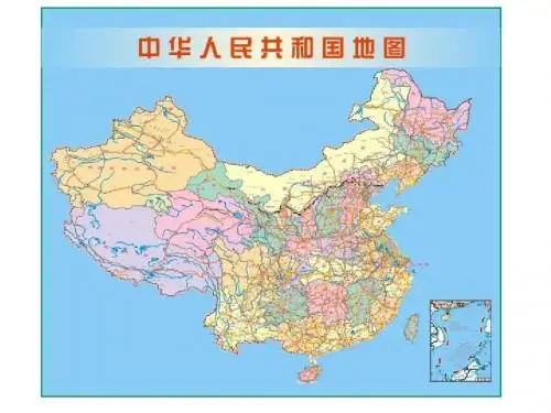
中华人民共和国地图
- 格式:ppt
- 大小:1.25 MB
- 文档页数:44

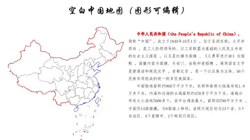
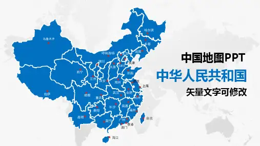
华北地区∙河北石家庄张家口承德秦皇岛唐山廊坊保定沧州衡水邢台邯郸∙山西太原大同朔州阳泉长治晋城忻州晋中临汾运城吕梁∙内蒙古呼和浩特包头乌海赤峰通辽呼伦贝尔兴安盟鄂尔多斯锡林郭勒阿拉善巴彦淖尔乌兰察布华中地区∙河南郑州三门峡洛阳焦作新乡鹤壁安阳濮阳开封商丘许昌漯河平顶山南阳信阳周口驻马店济源∙湖南长沙张家界常德益阳岳阳株洲湘潭衡阳郴州永州邵阳怀化娄底湘西∙湖北武汉十堰襄樊荆门孝感黄石咸宁荆州宜昌随州鄂州黄冈恩施仙桃天门神农架潜江东北地区∙黑龙江哈尔滨齐齐哈尔黑河大庆鹤岗佳木斯牡丹江大兴安岭伊春双鸭山鸡西七台河绥化∙吉林长春延边白城松原吉林四平辽源通化白山∙辽宁沈阳朝阳阜新铁岭抚顺本溪辽阳鞍山丹东大连营口盘锦锦州葫芦岛西南地区∙四川成都广元绵阳德阳南充广安遂宁内江乐山自贡泸州宜宾攀枝花巴中达州资阳眉山雅安甘孜凉山阿坝∙云南昆明曲靖玉溪丽江普洱临沧德宏怒江迪庆楚雄昭通大理红河保山文山西双版纳∙贵州贵阳六盘水遵义安顺毕节黔东南黔南黔西南铜仁∙西藏拉萨阿里昌都林芝日喀则山南那曲西北地区∙新疆乌鲁木齐昌吉克拉玛依吐鲁番哈密石河子伊犁巴音郭楞和田阿勒泰塔城阿克苏博尔塔拉克孜勒苏喀什图木舒克阿拉尔五家渠∙陕西西安咸阳渭南延安宝鸡汉中铜川榆林商洛安康∙甘肃兰州酒泉嘉峪关张掖天水白银定西甘南金昌临夏陇南平凉庆阳武威∙宁夏银川石嘴山固原中卫吴忠∙青海西宁果洛海北海东海南海西黄南玉树华南地区∙特别行政区香港澳门∙广东广州清远韶关河源梅州潮州汕头揭阳汕尾惠州东莞深圳珠海中山江门佛山肇庆云浮阳江茂名湛江∙广西南宁桂林百色玉林钦州北海梧州柳州河池防城港贺州来宾崇左贵港∙海南海口三亚琼海白沙保亭昌江澄迈儋州定安东方乐东临高陵水琼中屯昌万宁文昌五指山华东地区∙江苏南京徐州连云港盐城泰州镇江南通常州无锡苏州淮安宿迁扬州∙浙江杭州绍兴宁波湖州嘉兴金华丽水温州台州舟山衢州∙福建福州莆田南平厦门泉州漳州三明龙岩宁德∙山东济南聊城烟台威海青岛泰安莱芜济宁菏泽临沂德州淄博潍坊日照东营滨州枣庄∙江西南昌九江景德镇上饶鹰潭宜春萍乡赣州吉安抚州新余∙安徽合肥芜湖黄山安庆蚌埠亳州巢湖池州滁州阜阳淮北六安马鞍山宿州铜陵宣城淮南∙台湾中国概要中国(汉语拼音:Zhōngguó)位于亚洲东部,传统意义上和现代地理概念上涵盖大中华地区。


中华人民共和国地图编制出版管理条例文章属性•【制定机关】国务院•【公布日期】1995.07.10•【文号】国务院令[第180号]•【施行日期】1995.10.01•【效力等级】行政法规•【时效性】失效•【主题分类】测绘正文中华人民共和国国务院令第180号现发布《中华人民共和国地图编制出版管理条例》,自1995年10月1日起施行。
总理李鹏1995年7月10日中华人民共和国地图编制出版管理条例第一章总则第一条为了加强地图编制出版管理,保证地图编制出版质量,维护国家的主权、安全和利益,为经济建设、社会发展和人民生活服务,制定本条例。
第二条本条例适用于各种公开的普通地图和专题地图的编制和出版。
第三条编制出版地图,必须遵守保密法律、法规。
公开地图不得表示任何国家秘密和内部事项。
第四条国务院测绘行政主管部门主管全国的地图编制工作。
国务院其他有关部门按照国务院规定的职责分工,负责管理本部门专题地图的编制工作。
国务院出版行政管理部门商国务院测绘行政主管部门,负责管理全国的地图出版工作。
省、自治区、直辖市人民政府负责管理地图编制出版工作的部门及其职责,由省、自治区、直辖市人民政府规定。
军用地图和海图的编制管理,按照国务院、中央军事委员会的规定执行。
第二章地图编制管理第五条编制普通地图的,依照《中华人民共和国测绘法》的规定,必须取得相应的测绘资格。
编制专题地图,需要直接进行测绘的,依照《中华人民共和国测绘法》的规定,必须取得相应的测绘资格。
第六条在地图上绘制中华人民共和国国界、中国历史疆界、世界各国国界,应当遵守下列规定:(一)中华人民共和国国界,按照中华人民共和国同有关邻国签订的边界条约、协定、议定书及其附图绘制;中华人民共和国尚未同有关邻国签订边界条约的界段,按照中华人民共和国地图的国界线标准样图绘制;(二)中国历史疆界,1840年至中华人民共和国成立期间的,按照中国历史疆界标准样图绘制;1840年以前的,依据有关历史资料,按照实际历史疆界绘制;(三)世界各国国界,按照世界各国间边界标准样图绘制;世界各国间的历史疆界,依据有关历史资料,按照实际历史疆界绘制。
中国历史地图集以中国历代疆域政区为主的地图集。
谭其骧主编。
自原始社会至清末,按历史时期分为8册、20个图组,共304幅地图(插图未计在内)。
地图全部采用古今对照。
本图集从20世纪50年代起开始编纂,文化大革命时期受到严重干扰,1975年出版了内部版更是错误百出。
1982年起陆续出版了1-8册是研究我国历代行政区划不可多得的资料!目录1简介1. 1.1 内容2. 1.2 底图2作者简介3总编例1. 3.1 概述2. 3.2 若干幅3. 3.3 分幅图4. 3.4 断代年代5. 3.5 结语4书籍历史51996年版1.2.1简介内容内容包括:已公布的原始社会遗址和其他时期的重大遗址,各民族政权的疆域或活动范围、政区和一些部族的分布,秦以前可考地名、秦以后全部可考县以上政区(含县)和县以下重要地名的位置或范围,可考的长城、关津、堡塞、谷道、陵墓、庭帐等,主要的河流、湖泊、山岭及海岸线、岛屿等。
各册都有编例和地名索引,共收地名约7万个。
由中国地图出版社出版。
《中国历史地图集(1-8)》按历史时期分为8册:第一册:原始社会·夏·商·西周·春秋·战国时期;第二册:秦·西汉·东汉时期;第三册:三国·西晋时期;第四册:东晋十六国·南北朝时期;第五册:隋·唐·五代十国时期;第六册:宋·辽·金时期;第七册:元·明时期;第八册:清时期。
按年代分为20个图组,共有304幅地图(不另占篇幅的插图不计在内),549页。
地图上的内容包括:已知原始社会遗址和其他时期重要遗址的分布,中国历史上各民族建立的政权的疆域政区或活动范围、民族分布,秦以前见于记载?全部可考地名,自秦代开始全部县以上地名、一二级政区的界线,可考的长城、关津、堡寨、谷道、陵墓、庭帐等,主要的河流、湖泊、山岭、海岸线、岛屿等,共收地名7万多个。
CHAPTER 3. CARTOGRAPHIC MATERIALS3.1.Title and Statement of Responsibility Area3.1B1. Transcribe the title proper as instructed in 1.1B.245 00 $a Zhonghua Renmin Gongheguo fen sheng di tu ji245 00 $a 中华人民共和国分省地图集245 00 $a Beijing jiao tong di li zhi nan245 00 $a 北京交通地理指南245 00 $a Zhongguo cheng xiang jiao tong lü you tu ce245 00 $a 中国城乡交通旅游图册245 00 $a Zhongguo xing che di tu ce245 00 $a 中国行车地图册245 00 $a Dai Nihon dokushi chizu245 00 $a 大日本讀史地圖245 00 $a Chosŏn sidae chibang chido245 00 $a 朝鮮時代地方地圖245 00 $a Ku Hanmal Hanbando chihyŏngdo245 00 $a 舊韓末韓半道地形圖245 00 $a 3-chawŏn, Sŏul-si kyot‘ong chido245 00 $a Ch‘oegŭn Pukhan omanbun chi il chihyŏngdo245 00 $a 最近北韓五萬分之一地形圖245 00 $a Ŭngyong chijilto. $p Ponggye245 00 $a 應用地質圖. $p 鳳溪If the title proper is not taken from the chief source of information, give the source of the title in a note (see 3.7B3).3.1C1. Give immediately following the title proper the appropriate general material designation as instructed in 1.1C.245 00 $a Tōhoku Kyūshū chinetsu shigenzu $h [electronic resource] = $b Geothermalresources map of Tohoku and Kyushu245 00 $a Munchon, North Korea $h [electronic resource] : $b digital image city map 3.1D. Parallel titles3.1D1. Transcribe parallel titles as instructed in 1.1D.245 00 $a Qinghai Sheng di tu ce = $b Qinghaishengdituce245 00 $a 青海省地图册 = $b Qinghaishengdituce245 00 $a Zhongguo di tu = $b Atlas of China245 00 $a 中国地图 = $b Atlas of China245 00 $a Nei Menggu Zizhiqu di tu ce = $b Neimongol Zizhiqu dituce245 00 $a 内蒙古自治区地图册 = $b Neimongol Zizhiqu dituce245 00 $a Beijing xing che zhi nan = $b Driving guide in Beijing245 00 $a 北京行车指南 = $b Driving guide in Beijing245 00 $a Nihon chizuchō = $b Japan atlas245 00 $a 日本地圖帳= $b Japan atlas245 00 $a Suchi chizu 25000 (chimei kokyo shisetsu). $p Zenkoku $h [electronic resource] = $b Digital map 25000 (geographical names & public facilities). $p JapanAll245 00 $a Taehan Min’guk chido = $b The standard atlas of Korea245 00 $a 大韓民國地圖 = $b The standard atlas of Korea245 00 $a Taegu = $b Taqiu245 00 $a Kŭmjŏng-gu haengjŏng chido = $b Geumjeong-gu administration map3.1E. Other title information3.1E1. Transcribe other title information as instructed in 1.1E.245 00 $a Shanghai Shi di tu ce : $b gong zhong cha xun tu245 00 $a 上海市地图册 : $b 公众查询图245 00 $a Nihon bunken chizu chimei sōran, 1997 : $b kōkyō kikan, chikeizu sakuin,jidōsha rosen eigyō kiroteizu245 00 $a 日本分県地図地名総覧, 1997 : $b 公共機関, 地形図索引, 自動車路線営業キロ程図3.1E2. If the title proper does not include an indication of the geographic area covered by the item and if the other title information does not include such an indication or if there is no other title information, supply, as other title information, a word or brief phrase indicating the area covered.245 00 $a Outline development plan : $b [Hong Kong & Kowloon].245 00 $a Palto chido ch‘ongnon : $b [Chosŏn].245 00 $a Chizuchō.245 00 $a 地図帖.245 00 $a Shakaika chizuchō.245 00 $a 社会科地図帳.3.1F. Statements of responsibility3.1F1.Transcribe statements of responsibility relating to persons or bodies as instructed in 1.1F.245 00 $a Map of the People’s Republic of China / $c compiled & published by the Cartographic Publishing House = Zhonghua Renmin Gongheguo di tu / Di tu chuban she bian ji chu ban.245 00 $a Map of the People’s Republic of China / $c compiled & published by the Cartographic Publishing House = 中华人民共和国地图 / 地图出版社编辑出版.245 00 $a Zhongguo li shi di tu ji / $c Zhongguo she hui ke xue yuan zhu ban : Tan Qixiang zhu bian = The historical atlas of China / sponsor, Chinese Academy ofSocial Sciences ; chief editor, Tan Qixiang.245 00 $a 中国历史地图集 / $c 中国社会科学学院主办 ; 譚其驤主編 = The historical atlas of China / sponsor, Chinese Academy of Social Sciences ; chief editor, TanQixiang.245 00 $a Chikyū kansoku eisei Randosatto Nihon Rettō chizuchō = $b Landsatatlas, Japan / $c kanshū Sakata Toshifumi, Nakano Takamasa ; konpyūta gazōshori Tokai Daigaku Jōhō Gijutsu Sentā.245 00 $a 地球観測衛星ランドサツト日本列島地図帖 = $b Landsat atlas, Japan / $c監修坂田俊文, 中野尊正 ; コンピユータ画像処理東海大学情報技術セーター.245 00 $a Dai Nihon dokushi chizu / $c Yoshida Tōgo cho ; Ashida Koreto shūho.245 00 $a 大日本讀史地圖 / $c 吉田東伍著 ; 蘆田伊人修補.245 00 $a Sudokwŏn toro chido / $c Wŏn Kyŏng-nyŏl p‘yŏn.3.1F2. Add a word or short phrase to the statement of responsibility if the relationship between the title and the person(s) or body (bodies) named in the statement is not clear.245 00 $a Nihon bunken chizu chimei sōran, 1997/ $c [henshu] Jinbunsha Henshūbu.245 00 $a 日本分県地図地名総覧, 1997 / $c [編集] 人文社編集部.245 00 $a Gansu Sheng di tu ce = $b Gansu Sheng dituce / $c Zhongguo di tu chu ban she [bian zhi]245 00 $a 甘肃省地图册 = $b Gansu Sheng dituce / $c 中国地图出版社 [编制]3.1G. Items Without a Collective Title3.1G2. In describing as a unit a cartographic item lacking a collective title, transcribe the titles of the individual parts as instructed in 1.1G3.245 10 $a P‘yŏngt‘aek-si chŏndo ; $b P‘yŏngt‘aek-si chuyobu245 10 $a 평택시전도 ; $b 평택시주요부300 ## $a 2 maps on 1 sheet : $b both sides, col. ; $c 58 x 89 cm. and 89 x 59 cm., sheet94 x 64 cm.3.1G5.If a cartographic item lacking a collective title consists of a large number of physically separate parts, supply a collective title as instructed in 3.1B4.245 00 $a [Hong Kong, Kowloon, New Territories, and Islands topographic maps]245 00 $a [Chosŏn chido]245 00 $a [朝鮮地圖]3.2. Edition Area3.2B. Edition statement3.2B1. Transcribe a statement relating to an edition of a work that contains differences from other editions of that work, or to a named reissue of a work, as instructed in 1.2B.CHINESE EDITIONS250 ## $a Di 1 ban.250 ## $a 第1版.250 ## $a Di 4 ban, zui xin ban, quan xin gai ban.250 ## $a 第4 版, 最新版, 全新改版.250 ## $a Di 1 ban, 2005 xin ban.250 ## $a 第1 版, 2005 新版.250 ## $a Di 10 ban, chang xiao ban.250 ## $a 第10 版, 畅销版.JAPANESE EDITIONS250 ## $a Heisei 9-nenban.250 ## $a 平成9年版.250 ## $a Shinsōban.250 ## $a 新装版.250 ## $a CD-ROM ban.250 ## $a CD-ROM 版.EDITIONSKOREAN250 ## $a Che 3-p‘an.250 ## $a 第3版.250 ## $a Kŭmyangp‘an.250 ## $a 금양판.250 ## $a Kaejŏng chŭngbop‘an.250 ## $a 개정증보판.250 ## $a T‘ŭkpyŏl kihoekp‘an.250 ## $a 특별기획판.3.2B4. If an edition statement appears in more than one language or script, transcribe the statement that is in the language or script of the title proper. If this criterion does not apply, transcribe the statement that appears first.Optionally, transcribe the parallel statement(s), each preceded by an equals sign.245 00 $a Map of the People's Republic of China / $c compiled & published by the Cartographic Publishing House = Zhonghua Renmin Gongheguo di tu / Di tu chuban she bian ji chu ban.245 00 $a Map of the People’s Republic of China / $c compiled & published by the Cartographic Publishing House = 中华人民共和国地图 / 地图出版社编辑出版.250 ## $a 1st ed., Mar. 1984 = $b Di 1 ban, 1984 nian 3 yue.250 ## $a 1st ed., Mar. 1984 = $b第 1 版, 1984 年 3 月3.3. Mathematical and Other Material Specific Details Area3.3B. Statement of scale3.3B1. Give the scale of a cartographic item as a representative fraction expressed as a ratio (1: ). Precede the ratio by Scale. Give the scale even if it is already recorded as part of the title proper or other title information.255 ## $a Scale 1:1,100,000.3.4.Publication, Distribution, etc., Area3.4D. Name of publisher, distributor, etc.3.4D1. Give the name of the publisher, etc., and optionally the distributor, as instructed in 1.4D.260 ## $a Beijing : $b Zhongguo di tu chu ban she260 ## $a 北京 : $b 中国地图出版社260 ## $a Nagasaki : $b Ōhata Bunjiemon260 ## $a 長崎 : $b大畠文次衛門260 ## $a Tokyo : $b Jinbunsha260 ## $a 東京 : $b 人文社260 ## $a Sŏul-si : $b Sŏul Taehakkyo Kyujanggak260 ## $a 서울시 : $b 서울大學校奎章閣3.5. Physical Description Area3.5B1. Give the extent of a cartographic item. In the case of atlases and globes, give the number of physical units. In the case of other cartographic items, give the number of maps, etc. Use arabic numerals and one of the following terms. If the item is a manuscript, precede the term by ms.300 ## $a 1 globe300 ## $a 1 map300 ## $a 1 jigsaw puzzle300 ## $a 1 ms. map300 ## $a 10 maps300 ## $a 1 viewIf the sheets or parts of an item are very numerous and the exact number cannot be readily ascertained, give an approximate number.300 ## $a ca. 800 maps3.5C. Other Physical details3.5C4. Give the number of maps in an atlas as instructed in 2.5C.300 ## $a 1 atlas (1 v. (various pagings)) : $b maps300 ## $a 1 atlas (64 p.) : $b col. ill., col. maps300 ## $a 1 atlas (15, 59 p., [4] folded leaves of plates) : $b 4 col. maps3.5C5. Colour. If the item is coloured or partly coloured, indicate this. Disregard coloured matter outside a map, etc., border.300 ## $a 1 atlas ([56] p.) : $b col. ill., col. maps300 ## $a 4 maps : $b 2 col.300 ## $a 1 globe : $b col.300 ## $a 15 maps : $b some col.3.5C7.Material. Give the material of which the item is made if it is considered to be significant(e.g., if a map is printed on a substance other than paper).300 ## $a 1 map : $b col., plastic300 ## $a 1 map : $b col., silk3.5D. Dimensions3.5D1. … If a map, etc., is printed with an outer cover within which it is intended to be folded or if the sheet itself contains a panel or section designed to appear on the outside when the sheet is folded, give the sheet size in folded form as well as the size of the map, etc.300 ## $a 1 map : $b col. ; $c 67 x 90 cm., folded to 17 x 19 cm.3.5D2. Atlases. Give the dimensions of an atlas as instructed in 2.5D.300 ## $a 1 atlas (33 leaves) : $b chiefly col. ill., col. maps ; $c 59 cm.3.6. Series Area3.6B1. Record each series statement as instructed in 1.6.440 #0 $a Zhongguo gen shen xi lie di tu ce440 #0 $a 中国根深系列地图册440 #0 $a Hubei sheng shi, zhou ji zhi guan shi xi lie tu440 #0 $a 湖北省市洲际之冠世系列图440 #0 $a Nihon chizu senshū440 #0 $a 日本地圖選集490 1# $a Series = $a Zu bie ; $v HM50HFC490 1# $a Series = $a 组别 ; $v HM50HFC810 1# $a Hong Kong (China). $b Lands Dept. $b Survey and Mapping Office. $t Series ; $v HM50HFC440 #0 $a Munhwa chido ; $v 1440 #0 $a 문화지도 ; $v 13.7. Note Area3.7B1.Nature and scope of the item. Make notes on the nature or scope of a cartographic item unless it is apparent from the rest of the description. Also make a note on unusual or unexpected features of the item.500 ## $a Military topographic maps of Beijing area, China.500 ## $a Shows mountains, rivers, coasts, islands, towns, villages, roads, passes, drainage, and settlement patterns of Guangdong Province, including the LeizhouPeninsula and Hainan Island.500 ## $a Shows 24 provinces of China, including Taiwan. Also shows Korea and Japan.500 ## $a Shows administrative divisions and road network of Geumjeong-gu, Pusan, Korea.500 ## $a This map depicts the streets, temples, shrines, lakes and harbor of Nagasaki. In the harbor, ships from foreign countries are identified, namely ships from Chinaand Holland. The location of the foreign colonies of Holland and China are alsoidentified.500 ## $a Shows South and North Korea as a whole.(Item entitled: Taehan Min’guk chŏndo, 대한민국전도)3.7B4.Variations in title. Make notes on titles borne by the item other than the title proper. Optionally, give a romanization of the title proper.500 ## $a Sheets individually titled at top margin, e.g. Chang Ping Xian.500 ## $a Sheets individually titled at top margin, e.g. 昌平县.500 ## $a Each sheet individually titled in Chinese and English at top margin, e.g. Hubei Sheng di tu = Map of Hubei Province.500 ## $a Each sheet individually titled in Chinese and English at top margin, e.g.湖北省地图 = Map of Hubei Province.500 ## $a Title on case spine : Hizen Nagasaki zu.500 ## $a Title on case spine : 肥前長崎圖.500 ## $a Sheets separately titled in Hangul, Hancha, and romanization; and numbered,e.g. Illyŏn pŏnho, Toyŏp pŏnho NK52-7-30.3.7B6.Statements of responsibility. Make notes on variant names of persons or bodies namedin statements of responsibility if these are considered to be important for identification. Give statements of responsibility not recorded in the title and statement of responsibility area. Make notes on persons or bodies connected with a work, or significant persons or bodies connected with previous editions and not already named in the description.500 ## $a Maps copied and enlarged from: Zhongguo fen sheng di tu / Beijing di tu chu ban she. 1964.500 ## $a Maps copied and enlarged from: 中国分省地图 / 北京地图出版社. 1964.3.7B7. Edition and history. Make notes relating to the edition being described or to the history of the cartographic item.500 ## $a Revised edition of the map originally drawn by Huang Qianren in 1767.500 ## $a Revised edition of: Quan guo jiao tong ying yun xian lu li cheng shi yu tu.500 ## $a “Supersedes China: provisional atlas of Communist administrative units, published in 1959.”500 ## $a Earlier sheets produced by Republic of Korea Army Map Service.500 ## $a Edition statement varies: Che 1-p‘an = Ed. 1-KAMC – P‘ansu 2-KAMC = Ed.2-KAMC – P‘ansu 3-KAMC = Ed. 3-KAMC.3.7B9.Publication, distribution, etc. Make notes on publication, distribution, etc., details that are not included in the publication, distribution, etc., area and are considered to be important.500 ## $a One written insert is a brief preface, supplied by the publisher. The date and place of publication are found here.500 ## $a Originally published: [Tokyo] : Japan Rikuchi Sokuryōbu, Meiji 44 [1911]3.7B10.Physical description. Make notes on important physical details that are not included in the physical description area, especially if these affect the use of the item. If the item is a photoreproduction and the general term (photocopy) is used in the physical description area (see 3.5C3), give the generic name of the process, if it is likely to affect the use of the item (e.g., when it is a blueline print). …500 ## $a Blueprint.500 ## $a Bound in vellum.500 ## $a Wood block print.500 ## $a 2 folded col. maps in pocket.3.7B11. Accompanying material. Make notes on the location of accompanying material if appropriate. Give details of accompanying material neither mentioned in the physical description area nor given a separate description (see 1.5E).500 ## $a Accompanied by text: Explanation of the map of tourist geological resources of China. 23 p. ; 26 cm.500 ## $a Accompanied by text: Zhongguo yan rong huan jing di zhi tu 1:5 000 000 shuo ming shu. 60 p. ; 26 cm.500 ## $a Accompanied by text: 中国岩溶环境地质图1:5 000 000 说明书. 60 p. ;26cm.500 ## $a Accompanied by: Zhonghua Renmin Gongheguo ji qi pi lin hai qu di si ji di zhi tu shuo ming shu. 61 p. : maps ; 38 cm.500 ## $a Accompanied by: 中华人民共和国及其毗邻海区第四纪地质图说明书.61 p. : maps ; 38 cm.500 ## $a Accompanied by : "Zenkoku todōfuken shiku chōson-betsu" jinkō, setaisū, menseki ichiran ; Zenkoku shichōson henkō ichiran.500 Accompanied by : ”全国都道府県市区町村別”人口, 世帯数, 面積一覧; 全国 市町村変更一覧.500 ## $a Accompanied by text: Ŭngyong chijilto sŏlmyŏngsŏ, Ulchin chiyŏk = Explanatory text applied geological maps, the Uljin area. 58, 21 p. ; 26 cm.500 ## $a Accompanied by text: 應用地質圖說明書蔚珍地域 = Explanatory text applied geological maps, the Uljin area. 58, 21 p. ; 26 cm.3.7B12. Series. Make notes on series data that cannot be given in the series area.500 ## $a “Sŏji che 710-ho.”Series authority record:130 #0 $a Sŏji (Kungnip Haeyang Chosawŏn)서지 (Kungnip Haeyang Chosawŏn)$a430 #0 $a Pub. (Kungnip Haeyang Chosawŏn)667 ## $a Give as a quoted note.3.7B18.Contents. If a collection of maps is described as a unit (see 3.0J), make notes on the state of the collection at the time of description and indicate the composition of the complete collection if possible. Give variations between sheets in the collection. Complete this note when the collection is complete.List the contents of an item, either selectively or fully, including: insets; maps, etc., printed on the verso of a map, etc., sheet; illustrations, etc. Make notes on maps, insets, etc., on the recto before those on the verso of a sheet. Give the scale of insets, etc., if it is consistent. If the insets, etc., are numerous and/or minor, make a note in general terms.500 ## $a Corresponding pairs of Landsat images and maps on facing pages.500 ## $a Includes index.500 ## $a Includes location map and inset of ”South China Sea Islands.”500 ## $a Index to cho and chome names on verso of maps.500 ## $a Furoku: Zenkoku sōgō kaihatsu keikakuzu, Nihon toshi bunpuzu.500 ## $a 付録:全国総合開発計画図, 日本都市分布図.500 ## $a Includes: Chŏn’guk sigado, kungnip kongwŏn tŭngsan chido.500 ## $a Includes roads, distance tables, and descriptive text about each province and city.major500 ## $a “Digital, sinp‘yŏn,GPS iyong toro chosa”—Cover.500 ## $a Based on maps, at scale of 1:5,000 and 1:10,000, by Kungnip Chiriwŏn.500 ## $a Based on maps, at scale of 1:5,000 and 1:10,000, by 국립지리원. Compiled by: Wen-Ling Liu, Indiana UniversityTranscribed by: Youngsook Park and Philip Melzer, Library of CongressReviewed and updated by: Richard Fox, Tammy Tak-Yee Wong, and Min Zhang, Geography and Map Division, Library of CongressEdited by: Philip Melzer, Library of Congress January 3, 2006。