North Sea, Baltic Sea, the Norwegian Sea, and off the mainland coast of Africa and the US East Coast, and the northern Gulf of Mexico (Webb, 1955; Shepard and Dill, 1966; Blackwelder, 1931; Crough and Thompson, 1977; Lee, 1986; Briais et al., 1993, Hsu and Jing, 1958). The continental margin off China dehisced on the interior of the Eurasian plate during the early rift stage, then moved with the split plate forming a submarine imbricate rift and depression basin off the coast of China. The South China plate was squeezed by the subduction of the Pacific plate, leading to structural shrinkage and formation of orogenic belts in southeastern China.
The gradient of the topography offshore along the Chinese coast is steeper in the south than in the north, tilting toward the southeast (Sun et al., 1995; Yang, 1997; Guo et al., 2002). The submarine topography and morphology of the continental margin of the China Sea was not only affected by endogenetic forces (amassing of plates, vertical lift, extensional rift) but also by exogenetic forces such as runoff, ocean currents, sea-level fluctuations, and various sedimentary environments which formed features such as large-scale tidal sedimentary bodies, subaquatic deltas, and so on (Liu et al., 1997, 1998). Hence, the submarine topography and morphology off the coast of China, especially in regions with water depths shallower than 70 m, has been influenced by complicated factors and mechanisms and need to be further explored.
2 Geological Backgrounds
Our study area-the China offshore zone-is located in the northwest Pacific and extends along the east and south of the Chinese mainland. It includes the offshore regions of the Bohai Sea, Yellow Sea, East China Sea (ECS), and South China Sea (SCS). The offshore zone located on the continental margin sea inside the first island arc is parallelogram-shaped, with its long axis from NE to SW, along continental southeast Asia. The China Sea is composed of the Bohai Sea, Yellow Sea, ECS, and SCS and has a total length of 18,000 km along the mainland coastline (Liu et al., 1997).
The China Sea, located between the Eurasia Plate and Pacific Plate, is a marginal sea formed by the collision of the two plates. The marginal sea blocks a large amount of terrigenous material, mainly carried by rivers from the Asian continent, leading to the development of the continental shelf. Tectonic activity in the western Pacific created island arcs and trenches with active volcanoes and frequently occurring earthquakes, which are part of circum -Pacific tectonic belt formed during the Cenozoic. The entire marginal sea and adjacent zone are composed of several alternating fold belts and depressions. The tectonic zone stretches NNE–SSW to NE–SW and the formation age becomes younger from west to east (Liu, 1992). The young island arc and trench system lie NNE–SSW, east of the tectonic zone and are a fold belt of the Cenozoic continental shelf of the ECS and the Okinawa Trough with an outside rifting edge. The Taiwan fold belt is a southern extension of the continental shelf of the ECS. West of continental shelf of the ECS fold belt is a sequence of the following tectonic formations: the depression belt of the Cenozoic continental shelf of the ECS, the Zhejiang-Fujian uplift belt of the Mesozoic, the south Yellow Sea depression belt of the Meso-Cenozoic, and the Jiao-Liao uplift belt of the Paleozoic (Zhuang et al., 2008; Li, 2008). The NNE–SSW to NE–SW trending tectonic system is the result of several interactions between the Pacific plate and the Asian plate. The SCS can be divided into three major tectonic blocks lying NE–SW: (1) the central basin of the SCS, an ancient land with tensional fractures, (2) inside ancient land an oceanic crust formed by mantle upwelling and volcanic eruptions, (3) on both sides of central basin are the Xisha and Nansha ancient lands characterized by several events of mass subsidence. Northwest and southwest of the NE–SW trending tectonic blocks are the Cenozoic SCS continental and the Sunda subsided shelf basin (Liu, 2002). The western SCS, the Bohai Sea, the Yellow Sea, and the ECS are closely related to the Asian continent while the block of the eastern SCS and eastern Taiwan is affected by the Pacific tectonic activity.
3 Samples and Methods
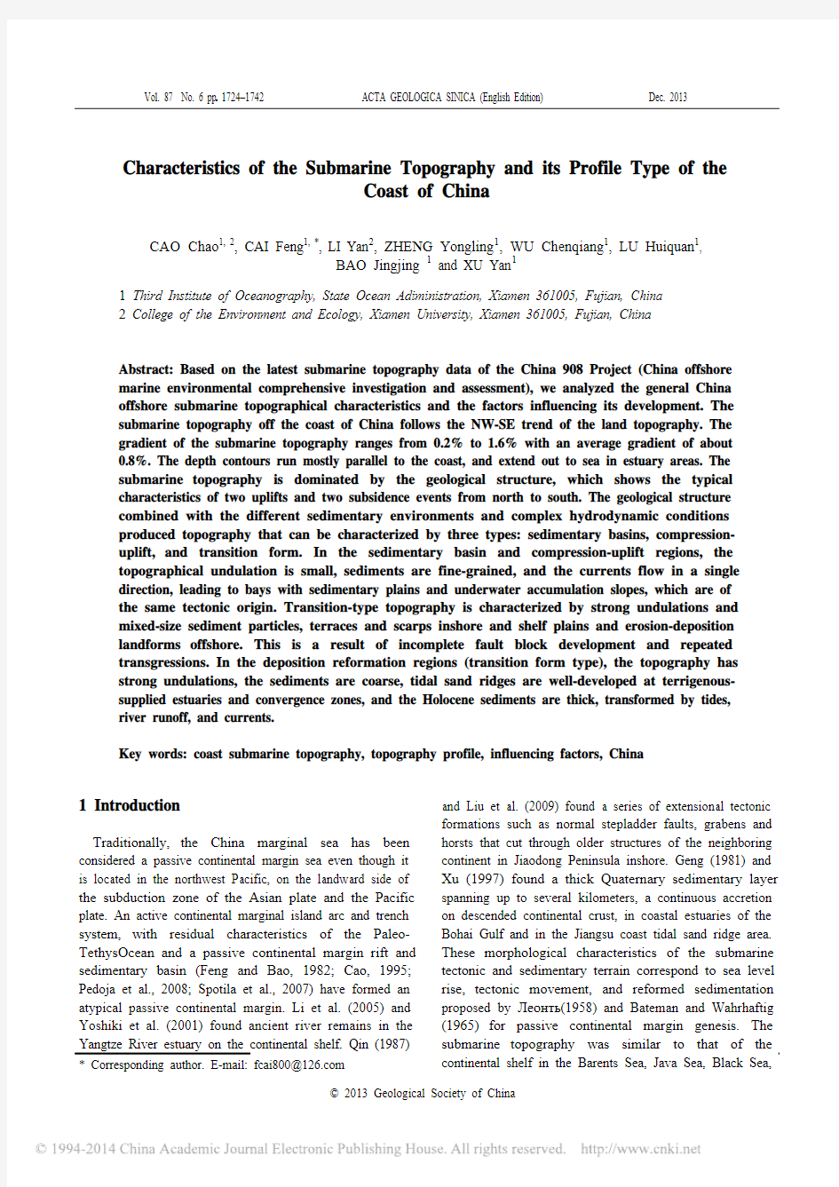
The study used data from the submarine topography and geomorphology survey of the “China 908 Project” which began in 2004. The study area covered the offshore region of 18°–41°N, 108°–125°E with a total area of about 34.5×10⁴ km2 at a depth of 70 m (Fig. 1). The topography survey line was about 77×104 km.
The Differential Global Positioning System (positioning accuracy better than 5 m) in the Coastal Radio Beacon and Differential Global Positioning System (RBN/DGPS) was used for navigation fixes in the field survey. The HYPACK MAX (Coastal Oceanography, UAS) marine comprehensive sequencing software and the Hi-Target navigation software were used for navigation (Table 1). Shallow-water multi-beam systems such as MKII180 (ELAC, Germany) and HD-27T (Hi-Target, China) echo sounder were used to measure the water depth. The survey lines were set along the topography lines. For the multi-beam system, the line spacing varied depending on the water depth of the survey area: 70 m for water depths of 10 m–15 m, 100 m for depths of 15 m–20 m, 140 m for 20
Fig. 1. 3D terrain map of survey area and the profile distribution.
The table shows the starting and ending point coordinates, trend, and length of the thirty-four profiles. The DTM image is based on data from the China 908 Project survey. The base map data was sourced from the Smith topographic database (QuickBird, 2009), grid of 5 km×5 km.
the continental shelf shows a gradual increase in depth from the continent to the sea basin, with the isobaths roughly parallel to the coastline, trending NE to SW. North of the ECS, the inshore topography is dominated by the underwater delta plain of the Yangtze River. The isobaths are tongue-shaped, extending seaward and the depth in most places is shallower than 20 m. The area from 122.5°E to 125°E is the Yangtze estuary tidal sand ridge zone, with a water depth of 30 m–60 m (Figs. 1 and 4). The alignment of the submarine topography changes gradually from N–S to N–W. The offshore area from 31.5°N to 23.5°N is a slope that lies in the NE–SW direction, its contours parallel to the shoreline and becoming denser from north to south with an average gradient of 1%. Profiles Y7–Y7', E1–E1', and E2–E2' show two submerged segments, a gentle slope or flat estuary subaqueous delta and inshore gulf plain, and a submarine fluctuating tidal sand ridge area with staggered grooves (Fig. 4). Profiles E3–E3', E4–E4', E5–E5', E6–E6', E7–E7', E8–E8', E9-E9', and E10–E10' have steep underwater slopes with gradients gradually increasing from north to south. The depth is mostly 70 m, the slope gradient decreases at a depth of around 55 m, where belts were at the boundary region between the inner and outer continental shelf (Li, 2005). In addition to the estuaries, the topography has other large fluctuations, such as in
profiles E9–E9' and E10–E10', which are affected by underwater erosion depressions and the residual platform of the Taiwan Strait. In most other regions, the topography is smooth, a result of underwater sedimentation on a gradual slope.
4.4 Topographic characteristics of the northern SCS The topography of the northern SCS is dominated by the continental shelf and narrow shelve plains. It is flat and trends NE–SW to ENE–WSW. Except for the narrow shelf southeast of Hainan Island, the continental shelf from Leizhou Peninsula (P3) eastward is very wide and gradually tapers from west to east. The maximum shelf width is about 300 km between Leizhou Bay (G2) and Wuchuan, but even the narrowest continental shelf at the Pearl River estuary extends to about 200 km. The isobaths of the continental shelf lie ENE to WSW paralleled to the coastline, with an average gradient of about 0.9%–1.2%. The gradient of the western Pearl River estuary is generally less than 1%, while the gradient of the eastern Pearl River estuary is higher. Along the inshore zone of the eastern Leizhou Peninsula within the 20-m isobaths, there are numerous estuaries, islands, and bays. Beibu Gulf on the western side of Leizhou Peninsula is a semi-enclosed bay open to the south; the submarine topography
is clearly restricted by the coast, and the depth in the bay
Fig. 2. Topographical profiles characteristic of the Bohai Sea.
The basement type in the Bohai Sea is mainly rift basin (Liu, 1992) and parts of the inshore segments indicate a depression basin. Sedimentary types
are mainly fine sand (Li, 2005) and coarse-particle silt in the estuary delta and central basin. The inshore segments of profiles B2–B2' and B5–B5' are concave-shaped, indicating an estuary delta slope. The vertical scale is 1:1000 and the horizontal scale is 1:125,000.
is mostly less than 90 m. The width of the northern Beibu Gulf (north of the 45-m isobaths) is about 150 km from south to north, and the submarine topography is flat, with an average gradient of only 0.3%. Strait topography can be found in the area between the Leizhou Peninsula and Hainan Island.
The 50-m isobaths run through the entire strait; the maximum depth is 118 m. At the outlet of the strait, the topography flattens rapidly and shoals; the geomorphology is that of a developed multi-finger delta. The topography of profiles S1–S1', S2–S2', S3–S3', S4–S4', S5-S5', and S7–S7' (Fig. 5) is steep and smooth, characterized by underwater sediment accumulation along a slope that extends to the continental slope (except for S1–S1' and S3–S3' that have three sections of submerged estuary topography). Profile S7–S7' is the steepest, with a maximum gradient of 1.6%, entering the continental slope area at a depth of 120 m. The gradient of profile S6–S6' is small, indicating a bay plain
stretching to a shallow sea basin. Profile S8–S8' has a concave shape in the coastal section, then slopes seaward for 25 km and enters a tidal delta area in the west of Qiongzhou strait (QS1) with prominent topography, and finally flattens to a shallow sea basin.
5 Discussions
Several factors affected the evolution of the China offshore submarine topography, the most important being the basic geology of the region, sea level changes, inshore hydrodynamic factors, and the evolution of the sedimentary environment. Here, we discuss these factors and their effect on the evolution of the topography of our study area.
5.1 Basic geological structure
Like the land topography, the submarine topography
Fig. 3. Topographical profiles characteristic of the Yellow Sea.
The basement types in the Yellow Sea are complex because of past tectonic activity (Liu, 1992). Complex hydrodynamic conditions have led to a variety of
geomorphological features (Cai et al, 2008; Fu, 2004). Sedimentary types are mainly fine and coarse particles in the estuary delta, Yellow Sea basin and tidal sand ridge in the Yellow Sea (Li, 2005). The vertical scale is 1:1000 and the horizontal scale is 1:125,000.
was the result of endogenetic and exogenetic forces. The large-scale submarine topography is a direct product of endogenetic forces related to seafloor spreading and plate collision. In addition, exogenetic forces play an important role in shaping the submarine topography in coastal and shallow water areas (Bull, 1984, Wheatcroft et al., 1997, Moore and Bray, 1978). The basic geological structure before the Cenozoic, and the tectonic activities and depositional environment during the Cenozoic were the main factors controlling the submarine topography and geomorphology off the coast of China. River systems eroded land, causing sediment discharge toward the sea, which accumulated on the seafloor and formed the continental shelf. While the river runoff provided the material that shaped the coastal plain, the monsoon forces, waves, tides, and currents performed a secondary role, controlling the development and trends of the coastal and submarine topography. These forces, combined with large-scale post-glacial transgression on the continental shelf, formed the offshore submarine topography we see today. Figure 6 shows the geotectonic movements that formed the framework of the current continental and offshore submarine morphology of China (Liu, 1992, Wang, 2002a,
Li, 2008, Cai et al., 2008). Since the Cenozoic, a series of
Fig. 4. Topographical profile characteristic of the ECS.
Profiles E1–E1' and E2–E2' are from the Yangtze River estuary and are over 300 km long, from the underwater delta and gulf plain to the tidal sand ridge
on the continental shelf. The basement types of the ECS are intermediate-acid rock and terrigenous because of squeeze tectonics affecting (Liu, 1992). A single hydrodynamic condition caused the underwater slope geomorphology (Cai et al., 2008; Fu, 2004; Li, 2005). The sedimentary types are mainly fine-grained while coarse particles are found in the residual platform of the Taiwan shallow depression (Li, 2005). The vertical scale is 1:1000 and the horizon-tal scale is 1: 125,000.
tectonic movements has been transforming and shaping the China offshore submarine topography. From the Late Cretaceous to the Oligocene, with the expansion of the westerns Pacific marginal seas, the oceanic crust of the Philippine Sea basin has evolved. At the edge of the continental shelf, west of the Lishui-Haifeng deep fault (F1), middle and small size graben basins developed, and large depressions formed in the areas of the Bohai Sea, North China Sea, Yellow Sea, and northern Jiangsu, where large amounts of terrestrial clastic rock was deposited (molasses) (Yoo et al., 2002). From the Late Oligocene to the Miocene, the Pacific plate subducted and compressed the continental margin trench; the tectonic movement was intense, a geosyncline folded and uplifted, and tension developed following the strong compressional action. The tensile expansion zone in the areas of the Japan Sea, Okinawa Trough, the SCS, and the Sulu Sea was formed under the effect of tensile graben faulting. Along with tensile expansion, tensional fracture of the slope and the shelf of the marginal sea occurred, and fault block depressions and uplifts formed. The depressions of the Bohai Sea and the Yellow Sea continued to develop under the action of the NE–SW to NNE–SSW oriented faults. Secondary Cenozoic sedimentary areas such as the Bohai rift (R1), Boxi uplift (U1), Liaodong Bay rift (R2), Bozhong rift (R3), and the Laizhou Bay rift (R4) appeared from west to east in the Bohai Sea, along with secondary small-scale staggered uplift fault areas in the Yellow Sea, such as the north depression (D1), center uplift (U2), south depression (D2), and Wunansha uplift (U3). The horizontal compressional movement of the coastal mountains in the mid-Miocene caused the unconformities and pseudo conformities between the South China uplifts and the SCS fold in the Yanshanian and the overlying strata. From the Late Pliocene to the early Pleistocene, the Philippine plate subducted strongly westward, the Penglai (Taiwan) movement occurred, the central mountain range rose sharply in Taiwan, and the oceanic basin fell dramatically while the continental depression extended
under the forces of extension tectonics (Alexander, 1991).
Fig. 5. Topographical profiles characteristic of the northern SCS.
The basement types in the northern SCS are mainly flysch, intermediate-acid rock, and aulacogen, as a result of past tectonic activity (Liu G D, 1992). The
geomorphology type is inclined underwater slope (Cai et al, 2008; Fu, 2004). The main sedimentary types are fine-grained and coarse particles distributed along the inshore slope and tidal delta of the northern SCS (Li, 2005). The vertical scale is 1:1000 and the horizontal scale is 1:125,000.
Fig. 6. Geological structure outline of the China offshore zone.
The China offshore topography is divided into two uplift zones (A2 and A4) and two depression basins (A1 and A3) by the Lishui–Haifeng fault, Tanlu fault and Wunansha fault (Liu G D, 1992; Li P Y, 2008; Cai et al, 2008). Vertical movement uplifted the large land block in South China while the block to the east (Pl1, Pl2 and Pl3) subsided during the early Pleistocene. The Taiwan block rose as the Philippine plate subducted westward and the islands of Taiwan was uplifted 5.14 mm/a (Guo, 2002; Sun, 1994).
The China offshore submarine topography, affected by actions of compression and tension, can be divided into two regions—north and south of the Hangzhou Gulf. The north part is characterized by two uplift zones, the Liaodong Peninsula uplift zone (A2) and the Shandong Peninsula uplift zone (A2), and two subsided zones, the North China–Bohai Sea depression basin (A1) and the North Jiangsu–South Yellow Sea depression basin (A3) which borders Hangzhou Bay (G3) and crosses the coastline of the northern ECS. The southern part is part of the South China uplift belt (A4), comprising mainly of mountains and hills with some small-scale depression basin plains in estuaries such as the Wenzhou plain (Pl1), Chaoshan plain (Pl2), and the Pearl River plain (Pl3) in the negative topography zones. Most of the submarine topography is controlled by faults striking NNE–SSW to NE–SW except for the areas along the coast of southern China which are controlled by the Nanling latitudinal-trending tectonic structures. The outline of partial bays and promontories is clearly dominated by faults with a NNE–SSW to NE–SW and NW–SE orientation and X-type fractures. China offshore submarine topographies could be classified by their geological structure into two types: (i) depositional topography, represented by the North China–Bohai Sea and northern Jiangsu–South Yellow Sea depression basins, which are characterized by a small average gradient, small fluctuations (Fig. 2, B1–B1’), concave offshore topography, and gentle offshore contours in the partial area (Fig. 2, B2–B2’). The topography is similar to that found at the landward side of the typical passive continental margin seen in the marginal basins along the Atlantic coast of the eastern United States (Goff et al., 1999; Clark et al.,2005), the Carolina groove (Bull and McFadden, 1977), and the Baltimore Canyon trough (Guo et al., 2002). (ii) Topography represented by the Southern China region which has a large average gradient with small undulations and steep straight protruded topography (Strahler, 1958, Slemmons, 1966). This is similar to the topography found at the landward side of the Manus Basin and the uplift platform in the partial area (Fig. 5). Maruyama (1997) used the subducted plate retention collapse model to explain the evolution of the Japan Sea (similar to the Manus Basin) and the China eastern island arc–trench system. Although the traditional overriding plates and eastward mantle flow induced plates which belong to the formation mechanism of the active continental margin (Stephan et al., 1986, Syvitski et al., 1996) differ from the topography found in this study, this indicates that the subduction of the Pacific plate and the Eurasian plate affects the submarine topography off the eastern and southern coast of China in a complex way (Karig, 1971; Lee et al., 2007).
From the Late Tertiary onwards, neotectonics have been quite active along the coast of China, creating offshore features characterized by different lifting movements of fault blocks (Ren, 1992, Hou et al., 1999). Ren and Li (2000) divided the inshore regions of eastern China into four neotectonic fault block activity areas (A1–A4) according to the different regional fault motion, intensity, and range (Fig. 3, Y0–Y0’). These different uplifting and subsiding movements transformed not only the original characteristics of the offshore submarine topography, forming the transitional topography between the depression and the uplift belt, but also modified the typical topography in the neotectonic fault block activity areas, forming a subclass topography.
5.2 Sea level and sedimentary environment evolution Global climate changes, especially glacial and interglacial periods inducing sea level changes, have a direct impact on the evolution of seafloor topography (Niino and Emery, 1961; Hubbard et al., 1979; Chen et al., 2003; Pang et al., 2012). The largest global sea level drop of the last glaciation occurred in the late Pleistocene about 18 ka. The present China continental shelf was exposed and the platforms evolved through tectonic uplift and weathering, forming a residual plateau terrain characterized by intermediate embossment and an irregular collapsed margin (Fig. 4, E9–E9’). The sea level then rose gently or stagnant period cycle oscillations of the sea level, more ancient strand bank deposit body a shallow sea shelf developed, such as ancient shell dike and ancient estuarine deposit body, a series of ladders and scarps (Fig. 3, Y0–Y0’ and Y9–Y9’) .
Although the submarine topography pattern off the coast of China was controlled mainly by tectonic movements and sea level change, ocean hydrodynamic forces also had an important effect on the characteristics of the terrain. The hydrodynamic conditions resulting from the direct forces of rivers, waves, and tidal currents shaped the coastal line and shallow topography (Wahrhaftig, 1965; DeMets et al., 1990; Fu, 2004; Nadin and Saleeby, 2010). Hydrodynamic forces formed flat shallow underwater deltas in the estuaries (Fig. 7), created channels, cut through the seafloor and scoured deep canyons by the capes, and formed erosion depressions. Loose sediments were sorted, transported, and deposited under hydrodynamic processes, and mud areas and sand areas formed through sediment redistributing and re-depositing (Bateman and Wahrhaftig, 1966; Liu, 1997, Syvitski et al., 1996, Goff et al., 1999). Finally, the original submarine shapes were modified, particularly on the river estuary (Fig. 4, E1–E1’ and E2–E2’).
The outline of the shelf off the coast of China is
Fig. 7. Main submarine geomorphologic types off the China coast.
The area between the red line and the coastline was surveyed by the “China 908 Project”; data from other zones was sourced from the China continental survey project and marine charts. The main geomorphological types were tidal flat, underwater delta, gulf plain, erosion-accumulation slope and plains, and tidal sand ridge.
constrained by structures lying NNE–SSW to NE–SW. Sediments which were eroded on the mainland and carried by the rivers into the sea were deposited in settling basins, and accumulated to form the present shallow continental shelf (Cui and Yin, 1995). When the inside basin of the Yellow Sea and the ECS were filled with sediment, the outside basin rim was still under the depositional process and being filled, so not enough fill material was found in the Okinawa trough. The South China coastal basin was also in the process of settlement and filling. Seabed deposits resulting from river discharge, enclosed by the structural ridge is the main characteristic of China offshore submarine sediment sources and dynamic deposit mechanism (Qin, 1987; Wang, 2002b). The sedimentation on the China offshore shelf is characterized by wide bands of sediments in the ECS and northern SCS (except in the Beibu Gulf), finer inshore, and coarser seaward; sediments were like macular distribution in the semi-open Bohai Sea, the Yellow Sea, and in Beibu Gulf. In the Bohai Sea, the shoreline, submarine topography, coastal currents, and warm current system showed a banded distribution (Wang, 2002a, Liu et al., 2009), indicating a zonality of the material supply, diffuser system, and sedimentation. In the Beibu Gulf, the shoreline twists and turns, and the submarine topography and hydrodynamics are changeable. The rivers carry a variety of materials, resulting in the macular distribution of the sediments (Li, 2005, Liu et al., 2004, 2007, Zeng et al., 2012).
5.3 Main hydrodynamic factors
Marine hydrodynamic conditions (such as waves, tides, ocean currents, and runoffs) are important factors affecting offshore submarine topography. Rivers transporting a large amount of sediments filled the sedimentary basins (such as A1 and A3) in the northern China offshore zone, forming thick Quaternary sediment layers. Sediments carried by the Bohai sea circulating current, and the Yellow Sea warm and coastal currents formed gulf accumulation plains and river delta plains in the estuaries with small tidal ranges (<4 m) and bays (Figs. 7 and 8). Sediments transported by tides formed tidal sand ridges and scoured deep grooves in strait outlets and tidal wave energy convergence areas and formed underwater terraces, erosion depressions, and erosion ravines around headlands and strong tidal range areas. Sediments from the Yangtze River, Pearl River and other rivers were discharged into offshore zones along the coast from the Yangtze offshore zone to the South China offshore zone (He, 2006; Oguri et al., 2000; Shi and Chen, 1996). The Zhe-Min coastal currents carried sediments from the Yangtze River towards the south and formed a subsidence muddy belt in the offshore zone. The bundle effect caused by the tributary of the Kuroshio and the SCS warm current in the western side of the Taiwan Strait forms a strong flow and strong tidal area, causing a decrease in the terrain gradient from south to north. This created an underwater erosion-accumulation slope (such as in profiles E8–E8' to E3–E3') and an erosion depression uplift in the residual terrain in the infralittoral zone (as seen in the offshore segment of profiles E9–E9' and E10–E10'). In the northern SCS, the small tidal range, slow bottom flow, and limited sediments formed a broad, shallow erosion-accumulation underwater slope and shelf. Thus, waves and currents not only shaped coastal and offshore geomorphology, formed sea cliffs, sea caves, sea platforms, beaches, underwater erosion slopes and other seabed geomorphology but also sorted, transported and re-deposited unconsolidated sediments, and finally formed mud areas and sand areas with smooth topography but complex geomorphology.
In summary, Figs. 9–11 show that the overall pattern of the submarine topography off the coast of China is constrained by the regional geological structure. The topographical profiles can be classified into three types: type I, sedimentary basin topography; type II, compressed and uplifted (orogenic belt); and type III, depositional basin–orogenic belt transitional topography (Feng and Bao, 1982; Cao, 1995; Li et al., 2005; Liu et al., 2009). The topography gradient of the Bohai Sea and South Yellow Sea was small, the average gradient was less than 0.5%, and the shape was normally flat, slightly concave with small slope fluctuation; this topography can be classified as sedimentary basin type (type I, Table 3), and can be divided into three subclasses: flat type, concave type, and transformation type. Compression-uplift topography (type II) is distributed mainly in the uplifted zone offshore of South China. This zone has a steep even slope with a gradient above 1%, and little fluctuation. The topography is steeper because of the Yanshanian extrusion movement along the Zhejiang and Fujian offshore zones. Type II topography can be divided into two subclasses: steep inclined type and fluctuation type (Table 3). Sedimentary transformation topography (type III), is found in estuarine deltas such as the Yangtze River and Pearl River estuary. This morphogenetic region was affected by the supply of Holocene rich terrigenous material. Close to the coast, a gentle delta sedimentary body develops and then rapidly subsides and connects with the inner continental shelf. Erosion is found in the partial area, its profile shows groups of tidal sand ridges with many peaks. Estuary and plain type topographies can be subclassed as type III2 (Table 3). The offshore topography in the northern part of the South Yellow Sea is steep, controlled by the Jiaoliao uplifted zone (A2). Erosion grooves appear in the nearshore area, as well as
Fig. 8. Hydrodynamic characteristics of China offshore zone.
The effects of river runoff, waves, tides, coastal currents, and sea currents are shown (Hou et al., 1996). Sediment discharge off northern China is higher than in the south. Tidal ranges in the bays and straits are larger than over underwater plains and deltas. Coastal currents throughout the China Sea carry a large amount of sediments from north to south.
some deep depressions with strong dynamics, and further offshore lies the central plain with a gentle topography. Normally, a large erosion-accumulation terrace is present between the erosion grooves and central plain; this topography belongs to the typical depositional basin–orogenic belt transitional type, and could be subclassed as terrace type and no-terrace type (type III1, Table 3).
6 Conclusions
(1) Generally, the submarine topography off the coast of China lies in a NW–SE direction; it follows the natural extension of the land topography and presents different
characteristics from north to south. The gradient of the
Fig. 9. Scatter diagram of profile average gradient and relief standard deviation.
Thirty-four profiles were divided into three types based on their average gradient and the standard deviation of the relief. Type I
was depression basin type, Type II was compression-uplift type, Type III was transition type. The characteristics of each type are
showed in Table 2.
Fig. 10. Chart of China submarine topographical profile types.
The submarine topography and geomorphology off the coast of China was influenced by endogenic and exogenetic forces and are divided into three main types and eight subclasses.
submarine topography was 0.2%–1.6%, with an average
gradient of about 0.8. It is mostly 0.3% in the Bohai Sea, Yellow Sea, and the Beibu Gulf, and mostly 1.0% in the northern Yellow Sea, ECS, and northern SCS. Except for the Jiangsu northern inshore region and the Yangtze River estuary, the isobaths lie parallel to the coast; the isobaths are sparse on the Bohai Sea, Jiangsu northern offshore area, Yangtze submerged delta, and Beibu Gulf, and dense in the northern Yellow Sea and Zhejiang-Fujian-Guangdong inshore area, indicating topographical characteristics of a coastal plain of the continental margin and shelf basin.
(2) The China offshore submarine topographies were dominated by tectonic activity and influenced by different depositional environments and complex hydrodynamic conditions. They can be classified into
three
Fig. 11. Schematic of China offshore submarine topography classification.
(a), Sedimentary basin (type I); (b), Compression-uplift (type II); (c), Transition (type III1); (d), Estuary-gulf (type III2).
accepted June 23, 2013
edited by Liu Lian References
Alexander, C.R., 1991. Sediments accumulation in a modern epicontinental-shelf setting the Yellow sea. Marine Geology, 98: 51–72.
Bao Jingjing, Cai Feng, Wu Chengqiang, Zheng Yongling and Lu Hhuiquan, 2011. Study on the Quality Evaluation of Chart-Splicing in Bathymetric Survey. Ocean Technology, 30(1): 10–14.
Bateman, P.C., and Wahrhaftig, C., 1966. Geology of the Sierra Nevada. In: Bailey, E. (Ed.), Geology of Northern California. California Division of Mines and Geology, Sacramento, CA, pp: 107–172.
Blackwelder, E., 1931. Pleistocene glaciation in the Sierra Nevada and Basin Ranges. Geological Society of America Bulletin, 42: 865–922.
Briais, A., Patriat, P., and Tapponnier, P., 1993. Updated interpretation of magnetic anomalies and seafloor spreading stages in the South China Sea: Implication for the tertiary tectonics of Southeast Asia. Journal of Geophysics Research, 98: 6299–6328.
Bull, W.B., 1984. Tectonic geomorphology.Journal of Geological Education, 32: 310–324.
Bull, W.B., and McFadden, L.D., 1977. Tectonic geomorphology north and south of the Garlock fault, California. In: Doehring, D.C. (Ed.), Geomorphology in Arid Regions, Proceedings 8th Annual Geomorphology Symposium.State University of New York, Binghamton, New York, 115–137.
Cai Feng, Qi Hongshuai and Xia Dongxing, 2008. Morphodynamics process of beaches in South China. Beijing: Ocean press, 56–77.
Cao Boxun, 1995. Geomorphology and Quaternary geology. Wuhan: China University of Geosciences press, 131–149. Chen Zhongyuan, Saito, Y., and Hori, K., 2003. Early Holocene mud-ridge formation in the Yangtze offshore, China: A tidal-controlled estuarine pattern and sea—level implications. Marine Geology, 198: 245–257.
Clark, M.K., Gweltaz, M., Saleeby, J., and Farley, K.A., 2005. The non-equilibrium landscape of the southern Sierra Nevada, California. GSA Today, 15: 4–10.
Crough, S.T., and Thompson, G.A., 1977. Upper mantle origin of Sierra Nevada uplift. Geology, 5: 396–399.
Cui Chenqi and Yin Pin, 1995. Basic characteristics and significance of coupled equilibrium theory in submarine slope morphologic development. Journal of Lake Science, 7(2): 126–131.
DeMets, C., Gordon, R.G., Argus, D.F., and Stein, S., 1990. Current plate motions. Geophysical Journal International, 101: 425–478.
Feng Wenke and Bao Caiwang, 1982. Topographic and geomorphological characteristics of South China Sea. Marine Geology Research, 2(4): 80–93.
Fu Mingzuo, 2004. On the evolutional model of the tectonic geomorphology of the Okinawa Trough. Institute of Oceanography, China Academy of Science, (Ph. D thesis): 20–25.
Geng Xiushan, 1981. The geomorphological features and forming factors of submarine relief in the Bohai sea and the Yellow sea . Acta Geographica Sinica, 36(4): 423–433. Goff, J.A., Orange, D.L., Mayer, L.A., and Hughes Clarke, J.E., 1999. Detailed investigation of continental-shelf morphology using a high-resolution swath sonar survey: the Eel margin, northern California. Marine Geology, 154: 255–269.
Guo Hua, Wu Zhengwen, Liu Hongxu and Wang Runrong, 2002. The overthrust-nappe tectonic framework of Yanshan intraplate orogenic belt. Geoscience, 16(4): 339–346.
He Qixiang, 2006.Marine sedimentary geology of China. Beijing: Ocean press, 68–70.
Hsu, K., and Jing, H., 1958. Isostasy and a theory for the origin of geosynclines. American Journal of Science, 256: 305–327. Hubbard, D.K., Oertel, G.F., and Numedal, D., 1979. The rule of waves and tidal current in the development of tidal-inlet sedimentary structures and body geometry: examples from North Carolina and Georgia. Journal of Sedimentary Petrol, 49(4): 1073–1092.
Hou Guitin, Ye Liangxin and Du Qinge, 1999, Tectonic mechanism and geological significance of the Bozhang fault zone. Geology Science, 34(3): 375–380.
https://www.doczj.com/doc/a44260855.html,/, 2009.
International Hydrographic Organization. 2008. IHO Standards for Hydrographic Surveys Special Publication No 44, 5th Edition. Monaco: International Hydrographic Bureau, 8–16. Karig, D.E., 1971. Origin and development of marginal basins in the western Pacific. Journal of Geophysical Research. 76: 2542–2561.
Lee, K., Lee, J., Owen, L.A., and Finkel, R., 2007. Late Quaternary slip rates along the Sierra Nevada frontal fault zone, California: slip partitioning across the western margin of the Eastern California Shear Zone-Basin and Range Province. Geological Society of America Bulletin, 119 (1-2): 240–256. Lee, P.X., 1986. Seafloor spreading and continental drift. Journal of Geophysical Research, 73: 3661–3697. Lambeck, K., 2004. Sea level change through the last glacial cycle: geophysical, glaciological and palaeogeographic consequences. Comptes Rendus Geoscience, 336: 677–689.
Li Guangxue, Liu Yong and Yang Zigeng, 2005. Yangtze old channel on the continental plain of East China Sea during the last glaciation. Science in China series D, 35(3): 284–289.
Li Jiabiao, 2008. East China Sea geology. Beijing: Ocean press, 256.
Liu Guangding, 1992. Geology of the China Sea – geophysics map. Beijing: Geology press, 3.
Liu Jun, Saito, Y., and Kong Xue, 2009. Geochemical characteristics of sediment as indicators of post-glacial environmental changes of the Shandong Peninsula in the Yellow Sea. Continental Shelf Research, 29: 846–855.
Liu Jun, Yoshiki, S., and Wang Hua, 2007. Sedimentary evolution of the Holocene subaqueous clinoform of the Shandong Peninsula in the Yellow Sea. Marine Geology, 236: 165–187.
Liu Jianping, Milliman J. D., and Gao Shu, 2004. Holocene development of the Yellow River’s subaqueous delta, North Yellow Sea. Marine Geology, 209: 45–67.
Liu Jianping, Xu Kaihua and Li Anchu, 2007. Flux and fate of Yangtze River sediment delivered to the East China Sea. Geomorphology, 85: 208–224.
Liu Zhaoshu, 2002. South China Sea geology. Beijing: Science press, 41.
Liu Zhenxia, 1997. Yangtze Shoal – a modern tidal sand sheet in the northwestern part of the East China Sea. Marine Geology,
137: 321–330.
Liu Zhenxia, Xia Dongxin and Berne, S., 1998. Tidal–depositional systems of China’s continental shelf, with special reference to the eastern Bohai Sea. Marine Geology, 145(3–4): 225–253.
Moore, J.G., and Bray, E., 1978. Mapped offset on the right-lateral Kern Canyon fault, southern Sierra Nevada, California. Geology, 6: 205–208.
Nadin, E., and Saleeby, J., 2010. Quaternary reactivation of the Kern Canyon fault system, southern Sierra Nevada, California. Geological Society of America Bulletin, 122 (9-10): 1671–1685.
Niino, H., and Emery, K.O., 1961. Sediments of shallow portion of East China Sea and South China Sea. Geological Society of America Bulletin, 72(5): 731–762.
Леонтье, O.K., 1958. Fundamental theory and problem on modern geomorphology. Beijin: Science press, 12–20. Oguri, K., Matsumoto, E., Saito, Y., Honda, M.C., Harada, N., and Kusakabe, M., 2000. Evidence for the offshore transport of terrestrial organic matter due to the rise of sea level: the case of the East China Sea continental shelf. Geophysical Research Letter, 27: 3893–3896.
Qin Yunshan, 1987.Geology of East China Sea. Beijin: Oceanpress, 100–110.
Pang Xiongqi, Liu Keyu, Ma Zhongzhen, Jiang Zhenxue, Xiang Caifu, Huo Zhipeng, Pang Hong and Chen Junqing, 2012. Dynamic Field Division of Hydrocarbon Migration, Accumulation and Hydrocarbon Enrichment Rules in Sedimentary Basins. Acta Geologica Sinica (English edition), 86(6): 1559–1592.
Pedoja, K., Shen Jian and Kershaw, S., 2008. Coastal Quaternary morphologies on the northern coast of the South China Sea, China, and their implications for current tectonic models: A review and preliminary study. Marine Geology, 255: 103–117. Ren Jianye, 1992. Continental extension, detachment fault and evolution of passive continental margins. Geological Science and Technology Information, 11(2): 11–17.
Ren Jianye and Li Sitian, 2000. Spreading and dynamic setting of marginal basins of the western Pacific. Earth Science Frontiers, 7(3): 203–213.
Slemmons, D.B., 1966. Cenozoic volcanism of the central Sierra Nevada, California. In: Bailey, E. (Ed.), Geology of Northern California. California Division of Mines and Geology, Sacramento, CA, pp: 199–208.
Shepard, F.P., 1973.Submarine Geology. 3ed. New York: Harper Row, 45–52.
Shepard, F. P., and Dill, R. F., 1966. Submarine canyons and other sea valleys. Chicago: Rand McNally, 40–45.
Shi Zhen and Chen Jinyin, 1996. Morphodynamics and sediment dynamics on intertidal mudflats in China (1961-1994). Continental Shelf Research, 16(15): 1909–1926.
Spotila, J.A., Niemi, N., Brady, R., House, M., Buscher, J., and Oskin, M., 2007. Long-term continental deformation associated with transpressive plate motion: the San Andreas fault. Geology, 35 (11), 967–970. Sun Dongqi, Chen Qiongxia, Cui SiQiong and Wu Guanghua, 1995. A study on the tectonic framework of the earth and the causative dynamics, Earth Science Frontiers, 2(1–2): 137–139.
Stephan, J. F., Blanchet, R., and Rangin, C., 1986. Geodynamic evolution of the Taiwan-Luzon-Mindoro belt since the late Eocene. Tectonophysics, 125(3): 245–268.
Strahler, A.N., 1958. Dimensional analysis applied to fluvially eroded landforms. Geological Society of America Bulletin, 69 (3): 279–299.
Syvitski, J.P., Alexander, C.R., Field, M.E., Gardner, J.V., Orange, D.L., and Yun, J.W., 1996. Continental-slope sedimentation: the view from northern California. Oceanography, 9, 163–167.
Wahrhaftig, C., 1965. Stepped topography of the southern Sierra Nevada, California. Geological Society of America Bulletin, 76: 1165–1190.
Wang Yin, 2002a. Radiative sandy ridge field on continental shelf of the Yellow Sea. Beijing: China Environmental Science Press, 101–105.
Wang Yin, 2002b. Radiative sandy ridge field on continental shelf of the Yellow Sea. Beijing: China Environmental Science Press, 12–18.
Webb, R.W., 1955. Kern Canyon lineament. In: Oakeshott, G.B. (Ed.), Earthquakes in Kern County, California, during 1952. California Division of Mines and Geology Bulletin, 171, 35–36.
Wheatcroft, R.A., Sommerfield, C.K., Drake, D.E., Borgeld, J.C., and Nittrouer, C.A., 1997. Rapid and widespread dispersal of flood sediment on the northern California margin. Geology, 25: 163–166.
Xu Dongyu, 1997. China offshore geology. Beijing: Geology press, 135.
Yang Shun, 1997. Tectonic framework and tectonic transformation of the pacific continental margin belts in the Mesozoic and Cenozoic, Earth Science Frontiers, 4(3–4): 247–255.
Yoshiki, S., Yang, Z.S., and Hori, K., 2001. The Huang he (Yellow River) and Chang jiang (Yangtze River) deltas: a review on their characteristics, evolution and sediment discharge during the Holocene. Geomorphology, 41: 219–231. Yoo, D.G., Lee, C.W., Kim, S.P., Jin, J.H., Kim, J.K., and Han, H.C., 2002. Late Quaternary transgressive and highstand systems tracts in the northern East China Sea mid-shelf. Marine Geology. 187: 313–328.
Zhuang Zhenye, Cao Lihua, Liu Shengfa and Hu Guangyuan, 2008. Activity level and balance signs of subaqueous dunes (waves) in the continental shelf.Periodical of Ocean University of China, 38(6): 1001–1007.
Zeng Jianhui, Guo Kai, Tian Kun and Xu Tianwu, 2012. Hydrodynamic Evolution and Hydrocarbon Accumulation in the Dabashan Foreland Thrust Belt, China. Acta Geologica Sinica (English edition), 86(4): 912–923.