Rural settlement land dynamic modes and policy implications
in Beijing metropolitan region,China
Guangjin Tian a,*,Zhi Qiao a,Xiaolu Gao b
a State Key Laboratory of Water Environment Simulation,School of Environment,Beijing Normal University,Xinwai Street,Beijing100875,PR China
b Key Laboratory of Regional Sustainable Development Modeling,Institute of Geographical Sciences and Natural Resources Research,
Chinese Academy of Sciences,PR China
a r t i c l e i n f o
Article history:
Available online
Keywords:
Rural settlements
Dynamic modes
Driving factors
Beijing metropolitan region a b s t r a c t
Rapid urbanization has transformed the landscape and function of rural areas in the periphery of the metropolitan regions of China.As a consequence of urbanization,more than900,000Chinese villages have disappeared during the past decade.However,the landscape patterns and factors driving rural-urban conversion have long been https://www.doczj.com/doc/5b17806708.html,ing medium-resolution Landsat TM(Thematic Mapper) data for1978,1988,2000,2005,and2008,and socio-economic data,the spatio-temporal dynamic patterns of rural settlements in the Beijing metropolitan region were analyzed.During the past30years, Beijing has experienced a33.6%increase in rural settlement land and a34.8%decline in its rural pop-ulation.The amount of rural settlement land per capita has increased dramatically.Following urban expansion,the major source of rural settlement land was cropland.Three modes of edge-expansion, dispersion,and urban encroachment were distinguished to study the dynamic pattern of rural settle-ments.Edge-expansion was the most common development type,and the proportion of land areas experiencing this dynamic mode was highest during the rapid expansion of rural settlement land.Rural settlement land initially developed around urban land,and then expanded to peripheral regions and remote villages.The expansion of rural settlement land and urban encroachment tended to be concentrated within3km of the urban center,and extended around the new urban development zone (NUDZ).This study investigated the dynamic modes of rural settlements and the drivers of a digital elevation model(DEM),such as distance to cropland,water bodies,roads and the urban center in the Beijing metropolitan region.The distance to water bodies had more impact on rural settlement land expansion than the distance to cropland.Urban expansion was in?uenced more by the distance to a road than the expansion of rural settlement land.To assist in the integration of urban citizens and farmers,the central government has implemented the“harmonious society”,“building a new countryside”,“scienti?c development”and“neo-urbanization”policies.In the Beijing metropolitan region,a scienti?c process of rural development planning is fundamental to reconsolidate the rural settlement land.
?2014Elsevier Ltd.All rights reserved.
Introduction
In2008,7.21?108people still lived in the rural areas of China, which accounted for54.3%of the total population(National Statistics Bureau of People's Republic of China,2009).The large size of this rural population means that one out of seven people on Earth is living in a rural settlement in China(Dumreicher,2008).These residents live in basic administrative units including town governments,township governments,and village committees under county governments. There were1.92?104town governments and1.5067?104township governments in2008and6.401?105village committees in2006 (National Statistics Bureau of People's Republic of China,2007,2009). However,the number of villages has declined substantially during the past decade in China as a result of rapid urbanization(China News-week,Nov.5,2012).Many young adults in the rural regions have moved to the cities,leaving behind communities of old people and children.These villages are often referred to as“empty villages”or “hollowed villages”(Chen,Sun,&Liu,2010;Liu,Liu,&Zhai,2009). There is even some concern over who will produce grain for the Chinese people in the future.Some people have attempted to protect the traditional culture in the rural villages.The villages(Nongcun), agriculture(Nongye),and farmers(Nongmin)are of great importance to the sustainability of China.To decrease the gap between urban citizenship and farmers,the central government has implemented
*Corresponding author.Tel.:t861058807808;fax:t861058800397.
E-mail address:tianguangjin@https://www.doczj.com/doc/5b17806708.html,(G.
Tian).Contents lists available at ScienceDirect Habitat International
journal homep age:www.elsevie https://www.doczj.com/doc/5b17806708.html,/locate/habit
atint
https://www.doczj.com/doc/5b17806708.html,/10.1016/j.habitatint.2014.06.010
0197-3975/?2014Elsevier Ltd.All rights reserved.
Habitat International44(2014)237e246
policies speci?cally referred to as“scienti?c development outlook”,“harmonious society”,“construction of new socialist countryside”and “neo-urbanization”.In2003,the policy“scienti?c development outlook”was proposed at the third plenary session of the16th Communist Party of China(CPC)national congress.The policy referred to balances in urban and rural development,regional development, economic and social development,harmonious development be-tween humans and nature,and national development and foreign open policy.It required local governments not only to try to ensure economic development but also to implement rural development and sustainable development.In2004,the Central Committee of the CPC proposed to build a“harmonious society”.This referred to the dem-ocratic and legal system,fairness and justice,honesty and friendship,a vibrant and dynamic society,safety and order,and harmony between humans and nature.It required the local government to ensure harmonious development between humans and the environment.In 2005,the?fth plenary session of the sixteenth CPC central committee proposed a plan to construct the“new socialist countryside”.This policy targeted product development,high standards of living,rural civilization,clean and tidy villages and democratic management.In 2012,Prime Minister Li Keqiang proposed the“neo-urbanization policy”.It emphasized the quality of urbanization and economized land and energy.The policy encouraged farm workers to migrate to cities and towns.The urbanization process should connect with agricultural modernization.The central government hoped to stim-ulate economic and social development and construct a harmonious society in the rural regions.
The major functions of rural settlements are living,farming,and forest production(Erickson,Ryan,&De Young,2002).For a long time,most residents of rural China were farmers;however,the landscape and function of rural settlements in China has changed dramatically.In some regions farmers have become a minority because of rural-to-urban migration.Farmers are increasingly leaving the industry,and many have become temporary workers in cities.This functional transformation of rural settlements has resulted in a general decrease in the importance of the primary sector of farming within rural communities.
The development of rural settlement land has changed the rural environment https://www.doczj.com/doc/5b17806708.html,nd development has been limited by the availability of land property.Current land development pat-terns have been strongly in?uenced by past development patterns, agricultural suitability,transportation,natural amenities,and eco-nomic and recreational characteristics(Gude,Hansen,Rasker,& Maxwell,2006).The localization of rural settlements has always been strongly dependent on natural resource exploitation(Domon, 2011).The proportion of homes built on highly productive soils has remained consistently high(Gude et al.,2006).Because of the in-?uence of early settlement patterns,newer homes will continue to be built near productive soils and water.
As the capital of China,Beijing is the second-largest city in China,with a total metropolitan population of16.95million in2008 (Beijing Statistics Bureau,2009),accounting for1.28%of the na-tional population.Among this population,about14.39million people(84.9%)lived in urban areas and2.56million people lived (15.1%)in rural areas.The urban expansion and dynamic pattern of the Beijing metropolitan region have been studied extensively (He,Okada,Zhang,Shi,&Zhang,2006;Qi et al,2004).The rapid urbanization process has transformed the landscape and functions of Beijing.However,the patterns and driving factors of rural set-tlement dynamics have long been neglected(Tian,Yang,&Zhang, 2007).
This study considers the patterns and driving factors of rural settlement dynamics in the Beijing metropolitan region.Have rural settlements expanded or declined?What are the major dynamic modes of change in rural settlements?Which factors have impacted on the dynamic modes of change in rural settlement?Our study will assist policy-makers in developing future land use policy for the Beijing metropolitan region.
China's rural policy and rural settlement dynamic modes As a consequence of rapid economic and social development, China's gross domestic product(GDP)per capita reached US$3405 in2008(NBSC2009).However,the income gap between the rural and urban population has widened from2.57to1in1978to2.81to 1in2008(NBSC2009).This large gap between the income of rural and urban residents has resulted in the immigration of farmers into urban areas.Young adults have immigrated into the urban areas from rural regions.To decrease the income gap and increase social stability,the central government has implemented the“scienti?c development outlook”,“harmonious society”,“construction of new socialist countryside”,and“neo-urbanization”policies.The central government anticipates that industries will support agriculture and cities will support the rural areas.
After1978,the rural areas were transformed dramatically in the Beijing metropolitan region.Rapid economic and social develop-ment changed the rural landscape.With the immigration of farmers into urban areas,the rural landscape has also been dramatically transformed.
Although there have been studies made of the different types of urban expansion,very few have considered rural settlement dy-namics(Tian,Jiang,Yang,&Zhang,2011;Tian et al.,2005;Tian,Liu, &Zhang,2002;Tian,Qiao,&Zhang,2012;Tian,Wu,Ouyang,& Quan,2011;Tian,Yang,&Xie,2007;Tian,Yang,&Zhang,2007). There are three basic modes of urban expansion,i.e.,in?lling,edge expansion,and spontaneous or outlying growth(Berling-Wolff& Wu2004;Liu,Li,Chen,&et al,2010;Xu et al.,2007).Other types of urban growth are recognized,such as linear development,large-scale projects,and clustered branches(Camagni,Gibelli,& Rigamonti,2002;Wilson,Hurd,Civco,Prisloe,&Arnold,2002). Linear development can be de?ned as a road-in?uenced form of urban expansion,and clustered branches can be de?ned as the formation of rural settlements.
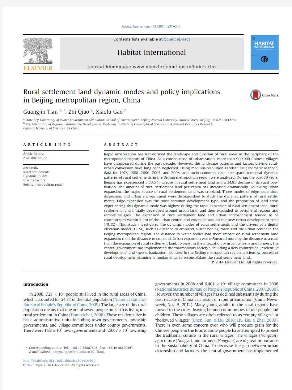
Very few in?lling and large-scale project modes of urban expansion have occurred in the rural settlement dynamics of China. We de?ned three modes of rural settlement dynamics that were important in China,i.e.,edge-expansion,dispersion,and urban encroachment(Fig.1).Edge-expansion is de?ned as a new patch of urban land,spreading in parallel strips from an edge(Forman,1995) (Fig.1a).If a new patch is isolated from an old patch,then the sit-uation is de?ned as dispersion expansion(Fig.1b).Urban encroachment is the conversion of a rural settlement into urban land(Fig.1c).The rapid expansion of Chinese cities has resulted in the encroachment of urban land into surrounding villages(Liu et al.,2010).Of the three modes,edge-expansion is considered to be the most compact mode of rural settlement expansion.Disper-sion is considered to be a diffusion pattern of rural settlement expansion.Urban encroachment is considered to encompass both urban expansion and rural reduction.It indicates that the urbani-zation process is ongoing.
The three modes have been used to study the spatial and tem-poral dynamics of rural settlement land.We study the impact of rural land policies on land use.
Study area,data sources,and methodology
Study area
Beijing,the capital of China covers an area of16,808km2.Since 1949,the city has been the national capital of the People's Republic of China.Two thirds of the Beijing metropolitan area is composed of
G.Tian et al./Habitat International44(2014)237e246 238
mountainous areas,which surround the city on the western,northern,and eastern sides.To the southeast of Beijing lies the North China Plain.
Data source
The land use of the Beijing metropolitan region has been studied at ?ve time periods (1978,1988,2000,2005,and 2008).Landsat TM/ETM images without clouds were selected for 1978,1988,2000,2005,and 2008at near anniversary dates.The images were chosen based on the vegetation phenology,and had been radiantly cor-rected.After the images were RGB false-color composed with 4,3,and 2bands,they were geo-referenced to 1:100,000scale relief maps.By studying the spectral re ?ectance,context,shades,and topography of the images and,using prior experience,interpreters identi ?ed the extent of land use and labeled the types of land use in the Beijing metropolitan area.These data sets were edited and compiled into vector https://www.doczj.com/doc/5b17806708.html,nd use data sets from 1978,1988,2000,2005,and 2008were manually interpreted.
Six aggregated classes of land use were derived:forest,cropland,grassland,water body,built-up land,and bare land.These classes were further divided into 25land use classes (Liu,Liu,et al.,2005;Liu,Tian,et al.,2005).The built-up land included urban land,rural settlement land,and industrial and mining sites.The urban land patches of the cities and townships were distinguished by the in-terpreters through the use of regional topographic maps.Patches of rural settlement land could be identi ?ed because the names and locations of villages were clearly labeled.The procedure for the visual interpretation of rural settlement land had been described previously (Tian,Qiao,&Zhang,2012).Because rural settlements are dispersed and one administrative village unit usually includes several rural land patches,the patches of rural settlement land did not completely match the administrative village units (Tian et al.,2012).To evaluate the accuracy of land-use classi ?cation,a ?eld survey was conducted.The identi ?cation of built-up land,with 1714selected patches,had the highest accuracy of 96.3%.The overall accuracy of the land cover classi ?cation for the 25sub-classes was 92.9%(Liu,Liu,et al.,2005;Liu,Tian,et al.,2005).
DEM (Digital Elevation Model)data were processed using the topographic map at the scale of 1:10,000,00.The road network was extracted from Digital Beijing data sets for 2003.The scale of the road network was 1:100,000and its coordinate system was WGS84.Water body data were extracted from the above land use data sets.All the data were projected using the Albers projection system.Methodology
The landscape metrics of rural settlement https://www.doczj.com/doc/5b17806708.html,ndscape metrics have been widely used to quantify landscape dynamics (Herold,Goldstein,&Clarke,2003;Seto &Fragkias,2005;Tian,Yang,&Xie,2007;Xie,Yu,Bai,&Xing,2006;Yu &Ng,2007).We selected the two metrics AREA and AIRRL to study the rural
settlement land dynamics in Beijing.AREA represents the area of the rural settlement land patches.We de ?ned AIRRL as the annual increment of rural settlement land.The de ?nition is as follows:
AIRRL ?
AREA b àAREA a
t
(1)
where AREA b is the rural settlement land area at time b ,AREA a is the rural settlement land area at time a ,and t is the time period.The dynamic modes of rural settlements.Rural settlement land dy-namics include the source and destination of rural settlement land.The sources of rural settlement land include cropland,forest land,grassland,water bodies,and other land.The development of rural settlement land includes the conversion to urban land,mining land,or other construction land.
To study rural settlement dynamic modes,a buffer zone analysis was calculated by ArcGIS 9.3.The rural settlement land expansion index (RCI)was de ?ned using the buffer analysis,which is one of the most important spatial analysis functions of ArcGIS 9.3.The buffers are the zones within speci ?ed distances around any new patch of rural settlement land (Fig.1a and b).We calculated RCI using the following functions of GIS:Analysis Tools,Overlays,and Intersects.
The RCI for a new patch of land can be de ?ned and calculated by examining the characteristics of its buffer zone (Liu et al.,2010).The equation is as follows:
RCI ?
A 0
A 0tA c
?100
(2)
where RCI is the rural settlement land expansion index,A 0is the intersection between the buffer zone and the occupied category,and A c is the intersection between the buffer zone and the vacant category.
If the newly grown patch develops through the edge-expansion mode,the area in the buffer zone is a mixture of vacant land and the old landscape (Fig.1a),and 0 The ecological zones of the Beijing metropolitan region.According to the Beijing General Plan (2004e 2020),moving out-ward from the center,the whole region can be divided into the Core Zone of Capital Function (CZCF),the Urban Function Extended Zone (UFEZ),the New Urban Development Zone (NUDZ),and the Ecological Preservation Development Zone (EPDZ)(Fig.2).The CZCF includes the Dongcheng district and the Xicheng district. The Fig.1.The three dynamic modes of rural settlement land. G.Tian et al./Habitat International 44(2014)237e 246239 UFEZ includes the Haidian district,the Chaoyang district,the Fengtai district,and the Shijingshan district.The NUDZ includes the Tongzhou district,the Shunyi district,the Fangshan district,the Daxing district,and the Changping district.The EPDZ includes the Huairou district,the Pinggu district,the Mentougou district,Miyun county,and Yanqing county.We analyzed the rural settlement land dynamics using the ecological zones of Beijing. The spatial regression analysis between the dynamic modes of change in rural settlement land and its driving factors.We studied the relationship between the rural settlement land dynamic modes of change and its driving factors using a spatial regression analysis (Tables 2e 4).For example,we regressed the distance to roads,and the area of rural settlement land dynamics.The equation was as follows: AREA ?a X i tb (3) where AREA is the area of rural settlement land expansion,X i is the driving factor of i ,and b is a constant.In addition to the distance to roads,driving factors also included the distance to cropland,water bodies,and the urban center,and the DEM.Results and analysis The dynamic pattern of rural settlements From 1978to 2008,the total population of Beijing increased by 94.5%(8.2?106people).The urban population increased dramat-ically by 200.4%,while the rural population declined dramatically by 34.8%(Table 1,Fig.3).However,the amount of rural settlement land expanded dramatically by 33.6%(279km 2).Hence,the average rural settlement land per capita had increased dramatically.The area of urban land increased at a slower rate than the rate of urban population growth.Urban land increased by 183.8%,while the ur-ban land per capita declined during the thirty years.Rural areas have used more residential land than urban areas. The expansions of rural settlement land did not occur evenly over the four periods studied.The area of rural settlement land expanded dramatically between 1988and 2005(Table 1,Fig.4).However,the area expanded slowly during 1978e 1988and even declined during the period from 2005to 2008(Table 1,Fig.4).From 1978to 1988,the urban population of China increased dramatically while the rural population increased slowly.For ten years,the rural population increased by 4.7%(1.85?105).The amount of rural settlement land expanded slowly because farmers did not build new houses during the time that the open policy was operational. From 1988to 2000,the amount of rural settlement land increased dramatically (by 285.2km 2),but 120km 2of rural set-tlement land was encroached upon by urban land.The annual increment (AIRRL)of rural settlement land growth was 13.8km 2(Table 1).The income per capita of a rural farmer increased with the industrialization of farming and the urbanization process.The in-come of a farmer increased to 4700Chinese Yuan in 2000,which was 1.8times the income of a farmer in 1988.This appreciation in farmer income stimulated housing construction.During this period,the rural population declined by 1?106.Many young farmers migrated to the cities.Although the rural population declined,the area of rural settlement land expanded dramatically.From 2000to 2005,the rural population declined by 5.4?105;however,the area of rural settlement land expanded by 182.4km 2.In those 5years,the per capita income of farmers increased by 56.8%.Within the Beijing metropolitan region,the area of rural settlement land area did not decline along with the rapid decline of the rural population. From 2005to 2008,the rural population increased by 4?104.However,the area of the rural settlement land declined by 0.5km 2.Although 36.9km 2of other land use types was converted to rural settlement land,urban land encroached upon 37.4km 2of rural settlement land over the same period.During this period,rural settlement land per capita decreased. From 1978to 2008,the primary industry productivity of Beijing increased 2.9times (Table 1).With the improvement of basic agricultural conditions and intensive agricultural management,the gross primary industrial productivity and the per capita income of famers increased accordingly.The primary industrial productivity per year increased dramatically (15.4%)during the period of 1978e 1988(Table 1).However,primary industrial productivity per year increased slowly during the three later periods (2.3%,3.9%and 3.2%,respectively)(Table 1).Although primary industry produc-tivity increased,the productivity declined dramatically,as compared to that experienced by the secondary and tertiary in-dustries (Table 1).This indicates that primary industry productivity increased more slowly than the secondary and tertiary industry productivity.Many farmers no longer work in agricultural ?elds as a result of the rapid development of village-owned and township-owned companies,and the growth of the tourism industry.In-dustrial development and the establishment of a tourism infra-structure have stimulated rural settlement land expansion.As living conditions have improved,the area of rural settlement land has increased. From the above analysis,it is clear that rural settlement land dynamics did not correspond with rural population changes and the incremental increase in primary industrial productivity.How-ever,both the rural population and primary industrial productivity declined during the thirty years studied. Fig.2.The ecological zones of Beijing metropolitan region. G.Tian et al./Habitat International 44(2014)237e 246 240 The source of rural settlement land dynamics Using the rural settlement land dataset and ArcGIS 9.3,we calculated the area of rural settlement land dynamics.The expan-sion of rural settlement land encroached on a large amount of cropland.About 90.6%,97.4%,92.6%,and 91.6%of new rural set-tlement land was cropland in each of the four periods,respectively.The major source of new rural settlement land was cropland.A minor portion of the new rural settlement land was forest land,grassland or a body of water.Hence,rural settlement land near Beijing has encroached upon cropland in a process similar to that in which urban land has encroached upon rural settlement land (Tian,Yang,&Zhang,2007). From 1988to 2000,the cropland lost to new rural development accounted for 4.7%of the total cropland of 1988.However,the cropland taken up by the expansion of rural settlement land decreased from 2000to 2005.Urban expansion was greater than the expansion of rural settlement land from 2005to 2008.A large amount of cropland is threatened by the encroachment of rural settlement land in China (Tian,Yang,&Zhang,2007).This phe-nomenon indicates that expansion of rural settlement land declined during the period from 2005to 2008.To ensure the continuity of grain farming,the central and local governments have implemented measures to protect grain cropland (Tian,Yang,&Zhang,2007).A decline in the expansion of rural settlement land will bene ?t China's ability to use land ef ?ciently.The construction of a new socialist countryside emphasizes the need to build the new rural settlements.Living standards and the environment will then be improved through countryside construction. A lot of rural settlement land was encroached upon by urban expansion.About 120km 2,74.9km 2,and 37.4km 2of rural settlement land were converted into urban land during the periods 1988to 2000,2000to 2005,and 2005to 2008,respectively (Table 1).During this twenty year period,the urban population increased by 200.4%.Many villages were converted into urban land during this rapid urban expansion.The farmers became urban cit-izens.Urban land expanded into the suburbs of villages.At the same time,the rural areas constructed township enterprises.These enterprises contributed signi ?cantly to the increase in rural in-come.In 2008,only 3%of the people involved in township enter-prises worked in agriculture.Of the people involved in township enterprises,48%,10%,8%,11%,7%,and 12%worked in manufacturing,construction,transportation,wholesale and retail,hotel and food,services,and other industries.More than 58%of the people were engaged in manufacturing and construction industries (BSB,2009).The income from manufacturing and construction accounted for 60%of the township enterprises.Agriculture employed only 3%of the township workforce,and generated only 1%of its income. The dynamic modes of change of rural settlements The spatial pattern of rural settlement land dynamics can be seen over the four periods (Fig.4).In this study,we considered three types of rural settlement land dynamics:edge-expansion,dispersion and urban encroachment.From 1978to 1988,the expansion of rural settlement land occurred slowly,with an overall increase in size of 6.8km 2.The edge-expansion and dispersion modes of change accounted for 75.4%and 24.6%of this increase,respectively.Although reform and open policy had been imple-mented in China by this time,the amount of rural settlement land still did not increase dramatically. Fig.3.The population dynamics and the area of rural settlement land in Beijing. Table 1 Basic development indicators in the Beijing metropolitan region from 1978to 2008.Year 1978e 19881988e 20002000e 20052005e 2008Cropland /Rural residential land (km 2) 6.2277.7168.833.8Forest /Rural residential land (km 2)0.1 1.19.3 2.7Grassland /Rural residential land (km 2)e 5.70.5e Water /Rural residential land (km 2)0.50.7 3.80.5Rural /Urban land (km 2)e 120.074.937.4Total area of changes (km 2) 6.8165.210 7.5à0.5Annual increment of rural residential land (AIRRL)(km 2)0.713.821.5à0.2Annual mean increment of rural population (104) 1.9à8.7à10.9 1.3Annual mean increment percentage of rural population in total population (%)à1.5à4.4à6.1à 2.7Annual mean increment rate of primary industry product (%)15.4 2.3 3.9 3.2Annual mean increment of primary industry percentage (%) 5.8 à10.2 à10.6 à8.9 G.Tian et al./Habitat International 44(2014)237e 246 241 From 1988to 2000,the area of rural settlement land area expanded dramatically (by 285.2km 2).The major mode of expan-sion was edge-expansion,which accounted for 97.9%of the total rural settlement land expansion.The dispersion mode accounted for 2.1%of the total rural settlement land expansion.During this period,edge-expansion was the predominant mode of expansion.At the urban edges,120km 2of rural settlement land was encroached upon by urban expansion. From 2000to 2005,the area of rural settlement land area increased by 182.4km 2.The edge-expansion and dispersion modes of change accounted for 85.4%and 14.6%of the expansion of rural settlement land,respectively (Fig.4).During this period,the proportion of dispersion mode expansion increased,as compared to the previous period. From 2005to 2008,the area of rural settlement land increased by 36.9km 2.The proportions of the edge-expansion and dispersion modes of expansion were 87.3%and 12.7%,respectively.The propor-tion of edge-expansion slightly increased in this period,while the proportion of dispersion mode expansion declined.However,urban expansion encroached upon 37.4km 2of rural settlement land,which surpassed the expansion of rural settlement land over the period,resulting in a net decline of rural settlement land in this period. Over the thirty years studied,edge-expansion was the major expansion mode,leading to changes in rural settlement land Fig.4.The spatial pattern of rural settlement land dynamics in Beijing in 1978e 2008. G.Tian et al./Habitat International 44(2014)237e 246 242 dynamics.Overall the proportion of edge-expansion increased while the proportion of dispersion decreased over the entire study period(Table1).However,the proportion of edge-expansion declined during1988e2000,then increased dramatically during 2000e2005,before slowly declining during2005e2008(Table1). Rural settlement land initially developed around the Beijing metropolitan region.Then,the expansion of rural settlement extended into the periphery of the metropolitan region,with remote villages also being slowly developed. The dynamic modes of change of rural settlement land in the ecological zones From1978to1988,59.9%of the edge-expansion and dispersion of rural settlement land development happened in the UFEZ,and the dispersion modes of expansion were concentrated in the Fengtai and the Haidian districts of the UFEZ. From1988to2000,more than60%of the edge-expansion and dispersion development was concentrated in the NUDZ.The edge-expansion in Fangshan district and the Shunyi district accounted for20.2%and14.1%of all edge-expansion,respectively.About65.4% of urban encroachment occurred in the UFEZ and26.4%occurred in the EPDZ. From2000to2005,the development of rural settlement land was concentrated in the NUDZ.The edge-expansion,dispersion, and urban encroachment modes of expansion in the NUDZ accounted for78.7%,59.1%and67%of the changes,respectively. Most of the edge-expansion happened in the Changping,Shunyi, Tongzhou,and Chaoyang districts.Urban encroachment occurred mainly in the Changping,Daxing,Shunyi,and Mentougou districts. From2005to2008,developments in the rural settlement land dynamics occurred in the NUDZ and the UFEZ.The edge-expansion and dispersion modes of expansion in the NUDZ accounted for 82.5%and80.6%of the changes,respectively.The dynamic change was concentrated in the Changping and Daxing districts.About 38.9%and59.7%of the urban encroachment occurred in the UFEZ and the NUDZ,respectively. From the above analysis,we can conclude that the rural settle-ment land changes were concentrated in the UFEZ from1978to 1988.After1988,the rural settlement land changes were concen-trated in the NUDZ.Hence,the area of rural settlement land changes extended from the UFEZ to the NUDZ.The expansion of rural settlement land initially occurred close to the urban center and then extended outward. The driving factors of rural settlement land dynamics The dynamic pattern of changes to rural land suggests a rela-tionship with underlying biophysical and economic developments. Proximity analysis was used to calculate the factors that in?uenced rural settlement land dynamics over considerable distances.To study the driving factors of edge-expansion,dispersion,and urban encroachment,we selected the following factors:DEM,distance to cropland,distance to a water body,distance to a road and distance to the urban center(Tables2e4).The DEM revealed the impact of topography on rural land dynamics.The distance to a road revealed the in?uence of infrastructure.Distance to a water body was a physical factor.There were few changes to rural settlement land between1978and1988.Therefore,we only studied the other three periods(1988e2000,2000e2005,and2005e2008). The DEM is the most important factor relating to the rural environment.The DEM indicates the physical conditions,which impact on the development,size,structure,and pattern of rural settlement land(Tian et al.,2012).Between1988and2000,65.71% of all changes to rural settlement land occurred in regions where the DEM indicated an elevation of between0and50m.About21.2% of all changes to rural settlement land change occurred in regions where the DEM indicated an elevation of between50and100m. From2000to2005,79.8%of all changes to rural settlement land change occurred in regions where the DEM indicated an elevation of between0and50m,while94.2%of all changes to rural settle-ment land change occurred in these regions from2005to2008. Thus,most of the rural settlement land development occurred in regions where the DEM indicated an elevation of between0and Table2 Relationship between rural settlement land dynamics and driving factors in the Beijing metropolitan region from1988to2000. Rural settlement land dynamics DEM Distance to cropland Distance to water body Distance to road Distance to urban land Edge-expansion y?à4.138xt54.81y?à4.381xt62.52y?-2.237xt37.90y?à0.987xt25.56y?à0.764xt25.57 R2?0.277R2?0.152R2?0.803R2?0.563R2?0.263 Correlation Weak correlation Signi?cant correlation Strong correlation Correlation Dispersion y?à0.228xt2.453y?à0.125xt1.306y?à0.048xt0.879y?à0.468xt2.743 R2?0.373R2?0.372R2?0.335R2?0.399 Correlation Correlation Correlation Correlation Urban encroachment on rural residential land y?à5.312xt52.67y?à0.853xt14.64y?à1.096xt16.81y?à0.998xt16.92y?à21.14xt82.28 R2?0.455R2?0.573R2?0.635R2?0.354R2?0.985 Correlation Strong correlation Strong correlation Correlation Signi?cant correlation R2<0.2?weak correlation;0.2R2<0.5?correlation;0.5R2<0.6?strong correlation;R2!0.6?signi?cant correlation. Table3 Relationship between rural settlement land dynamics and driving factors in the Beijing metropolitan region from2000to2005. Rural settlement land dynamics DEM Distance to cropland Distance to water body Distance to road Distance to urban land Edge-expansion y?à5.727xt50.20y?à2.839xt34.56y?à2.089xt27.92y?à0.53xt13.64y?à6.721xt52.54 R2?0.285R2?0.191R2?0.649R2?0.695R2?0.631 Correlation Weak correlation Strong correlation Strong correlation Strong correlation Dispersion y?à0.021xt8.943y?à1.193xt9.387y?à0.451xt5.484y?à0.091xt2.346y?à1.368xt9.858 R2?0.293R2?0.236R2?0.559R2?0.402R2?0.551 Correlation Correlation Strong correlation Correlation Strong correlation Urban encroachment on rural residential land y?à0.073xt32.21y?à0.00003xt3.842y?à0.832xt11.59y?à0.515xt9.367y?à18.27xt59.68 R2?0.485R2?2?10à6R2?0.216R2?0.416R2?0.921 Correlation No correlation Correlation Correlation Signi?cant correlation R2<0.2?weak correlation;0.2R2<0.5?correlation;0.5R2<0.6?strong correlation;R2!0.6?signi?cant correlation. G.Tian et al./Habitat International44(2014)237e246243 100m.Moreover,the proportion of rural settlement land changes in regions with an elevation of between 0and 50m increased over time.Rural settlement land changes tended to occur in the North China Plain region and,therefore,more rural land development occurred on the plains.Correlations between the DEM results and the three modes of rural settlement land dynamics were not high (Tables 2e 4).Only the correlation between urban encroachment and the DEM from 2005to 2008was strong (R 2?0.767).The impact of the DEM on urban encroachment was larger than the impact of the DEM on the expansion of rural settlement https://www.doczj.com/doc/5b17806708.html,pared with the expansion of rural settlement land,urban expansion tended to occur more frequently in the plain region.However,the development of rural settlement land also occurred on the plain. Cropland refers to land that is suitable and available for grain production.Changes in cropland have been the most important driving factor in the expansion of rural settlement land.From 1988to 2008,the edge-expansion of rural settlement land had a weak correlation with distance to cropland (Tables 2e 4).The dispersion of rural settlement land had no correlation with distance to crop-land during the periods 1988to 2000and 2005to 2008.The dis-tance to cropland was correlated with dispersion from 2000to 2005(Tables 2e 4).However,urban expansion had a strong corre-lation,no correlation,and a weak correlation with the distance to cropland for the three periods,respectively (Tables 2e 4).Hence,cropland had much less impact on urban encroachment than on the expansion of rural settlement land.Cropland had less impact on the expansion of rural settlement land in the later periods. The presence of a body of water is an important factor that has an impact on rural settlement land dynamics.Most of the rural settlement land changes occurred in regions where the distance to a body of water was less than 2km.The development of rural settlement land within a 2km buffer from a body of water accounted for 56.5%,75.3%,and 59.2%of the total expansion of rural settlement land during the three periods,respectively.Urban encroachment into rural settlements within a 2km buffer from a body of water accounted for 40.6%,51.8%,and 46%of the total urban encroachment for the three periods,respectively.The presence of a body of water had a much greater impact on the expansion of rural settlement land than on urban encroachment.The edge-expansion of rural settlement land had a signi ?cant and strong correlation with the distance to a body of water during the period from 1988to 2008(Tables 2e 4).The dispersion of rural settlement land was correlated with the distance to a body of water over the period studied,while urban encroachment was strongly correlated with the distance to a body of water (Tables 2e 4).The expansion of rural settlement land has been in ?uenced by the presence of bodies of water.Hence,the location of bodies of water has had a greater impact on rural settlement land dynamics than the location of cropland. The location of roads is one of the most important driving fac-tors of rural settlement land dynamics.About 27.4%,17.9%,and 13.1%of the expansion of rural settlement land has happened within 0e 0.05km of major roads in the area during the three pe-riods (1988e 2000,2000e 2005,and 2005e 2008),respectively.Urban encroachment into rural settlement land is more in ?uenced by the location of roads than the expansion of rural settlement land.About 40.6%,30.5%,and 17.8%of urban encroachment occurred in the buffer zone,where the distance from a major road was between 0and 0.05km during the periods 1988to 2000,2000to 2005,and 2005to 2008,respectively.However,the in ?uence of the distance to a road declined over time.The edge-expansion mode of rural dynamics was most strongly impacted by the location of major roads.About 189.3km 2of edge-expansion happened within a 0e 0.3km distance from a road,which accounted for 67.9%of the total edge-expansion from 1988to 2000.The dispersion mode in the buffer zone accounted for 78.8%of the expansion of rural set-tlement land.Edge-expansion was correlated with the distance to a road,with some strong correlations during the course of the three periods (Tables 2e 4).The dispersion mode and urban encroach-ment were correlated with the distance to road.The roads are the major transportation routes in the region.The locations of new homes are selected to maximize their accessibility to major roads.The location of the urban center impacts on rural settlement land dynamics.Rapid urban expansion has encroached on rural settlement land in the suburbs.The expansion of rural settlement land has been particularly extensive within 3km of the urban center.Expansion of rural settlement land within 3km from the urban center accounted for 74.3%,94%,and 94.9%of the total expansion of rural settlement land for the three periods,respec-tively.Urban encroachment into rural settlement land within 3km from the urban center accounted for 100%,99%,and 98.6%of the total urban expansion for the three periods,respectively.The edge-expansion mode of expansion was correlated with the distance to the urban center over the entire period studied,while the disper-sion mode of expansion was strongly correlated with the distance to the urban center (Tables 2e 4).The correlation coef ?cient be-tween urban encroachment and the distance to the urban center was signi ?cant (Tables 2e 4).The proportion of the total expansion of rural settlement land that occurred close to the urban center increased over the three periods.Hence,the expansion of rural settlement land moved closer to the urban center over time.Discussion The central government is currently implementing a “neo-ur-banization ”policy.The policy encourages farmers to migrate into the cities and townships.Although large numbers of the rural population have migrated into urban areas,they cannot register with China's permanent residence registry system (Hukou ).In China,only 35%of the population is recorded in the permanent urban residence registry system.Nearly 40%of people (roughly 260million)living in urban areas are migrants (NBSC,2010).They are temporary workers (referred to as “farmer workers ”),who work in Table 4 Relationship between rural settlement land dynamics and driving factors in the Beijing metropolitan region from 2005to 2008.Rural settlement land dynamics DEM Distance to cropland Distance to water body Distance to road Distance to urban land Edge-expansion y ?à2.625x t17.22y ?à0.761x t67.687y ?à0.329x t4.865y ?à0.168x t3.418y ?à1.724x t12.64R 2?0.336R 2?0.197 R 2?0.581 R 2?0.522 R 2?0.641 Correlation Weak correlation Strong correlation Strong Correlation Strong correlation Dispersion y ?à0.288x t2.613y ?à0.036x t0.637y ?à0.049x t0.738y ?à0.429x t2.283R 2?0.379R 2?0.248R 2?0.268R 2?0.778 Correlation Correlation Correlation Strong correlation Urban encroachment on rural residential land y ?à18.18x t48.83y ?à0.400x t5.811y ?à1.014x t9.668y ?à0.153x t3.619y ?à10.90x t34.09R 2?0.767 R 2?0.123 R 2?0.539 R 2?0.06 R 2?0.994 Strong correlation Weak correlation Strong correlation No correlation Signi ?cant correlation R 2<0.2?weak correlation;0.2 R 2<0.5?correlation;0.5 R 2<0.6?strong correlation;R 2!0.6?signi ?cant correlation. G.Tian et al./Habitat International 44(2014)237e 246 244 the cities temporarily or seasonally while their permanent homes remain in the rural areas. As a result of the rapid urbanization and industrialization pro-cess,more farmers are expected to migrate to cities and townships in the Beijing metropolitan region.The rapid urbanization and industrialization process has transformed the economic and social systems of the rural regions.The residential land expansion process operates in three ways:urban encroachment,edge-expansion,and dispersion.A large number of people have moved to the cities.Even in the rural regions,only a few farmers are still engaged in the primary industry of agriculture.Most farmers are working in the secondary and tertiary industries in the Beijing metropolitan re-gion.In the rural regions,the farmers retain their old houses, although they have moved to cities.These houses subsequently decline because they lack proper maintenance.More rural settle-ment land has been developed to build new houses with an in-crease in the per capita income of farmers.Therefore,the amount of rural settlement land per capita has substantially increased. Rural development is one of the most dramatic forms of land use change.It results in the loss of cropland,forest land,and water bodies,which,in turn,affects biodiversity,ecosystem functions, and the services available in rural areas.The landscape of rural areas has been substantially transformed from cropland into a“new countryside”.Rural settlement landscapes are regarded as portions of land for the visual amenity of visitors(Domon,2011).Many villages have developed tourist programs that attract urban citi-zens.In2008,there were1332agricultural tourist gardens, attracting about49,366visitors(BSB2009).Rural settlements are a modi?ed form of wild landscape,and their expansion has an ecological impact on forests and water bodies.The cultural ele-ments of an idyllic landscape with scattered rural settlements needs to be preserved(Long,Liu,Wu,&Dong,2009).Rural set-tlements close to water bodies tend to be developed more exten-sively.Hence,the protection of wetland should be given more attention. Conclusion The expansion of rural settlement land occurred close to the urban center at?rst.Development then extended to the peripheral regions.Remote villages developed much more slowly.Although the regional authority has restricted real estate development by farmers in the suburbs of the cities,the farmers still developed their houses for sale to immigrants from other provinces.According to the land management law of the People's Republic of China,rural land cannot be developed unless it is expropriated into national land.Hence,the regional authority has a responsibility to restrict rural development around the suburbs of the Beijing metropolitan region. Urban land has been used intensively because of its high value. However,rural settlement land has also been used extensively. Policy-makers should give more attention to the waste and in-ef?ciency of rural land use in the Beijing metropolitan region.It is of great importance to intensify rural land https://www.doczj.com/doc/5b17806708.html,nd consolidation has been used to intensify rural settlement land in some regions of China (Liu,2007).However,the consolidation of rural settlement land has not been widely implemented because of the lack of economic feasibility.Of the three modes of expansion,edge-expansion was the most common type of rural settlement land development.In terms of area,the proportion of this mode of expansion dominated during the period of rapid expansion of rural settlement land.However, dispersion still accounted for12.7%of the total expansion of rural settlement land during2005e2008.In terms of land use economics, edge-expansion should be encouraged.Townships and central vil-lages should be developed while dispersion should be restricted.The study of patterns of rural dynamics and the modes of rural change is crucial for a better understanding of the processes of rural dynamics. The results of these studies will provide valuable information that will be helpful to of?cials,planners,and developers in making de-cisions regarding the potential effects of residential development on ecological safety. Acknowledgments This study was funded by the Key Laboratory of Regional Sus-tainable Development Modeling,Institute of Geographical Sciences and Natural Resources Research,Chinese Academy of Sciences;key projects in the National Science&Technology Pillar Program of China during the Twelfth Five-Year Plan Period(2012BAC13B01);and the National Natural Science Foundation of China under grant41071357. References Beijing Statistics Bureau(BSB).(2009).Beijing statistical yearbook2009.Beijing: China Statistics Press. Berling-Wolff,S.,&Wu,J.(2004).Modeling urban landscape dynamics:a case study in Phoenix,USA.Urban Ecosystem,7(3),215e240. Camagni,R.,Gibelli,M.,&Rigamonti,P.(2002).Urban mobility and urban form:the social and environmental costs of different patterns of urban expansion. Ecological Economics,40,199e216. Chen,Y.F.,Sun,H.,&Liu,Y.S.(2010).Reconstruction models of hollowed villages in key agricultural regions of China.Acta Geographica Sinica,65(6),727e735. Domon,G.(2011).Landscape as resource:consequences,challenges and oppor-tunities for rural https://www.doczj.com/doc/5b17806708.html,ndscape and Urban Planning,100(4), 338e340. Dumreicher,H.(2008).Chinese villages and their sustainable future:the European Union-China-Research Project“SUCCESS”.Journal of Environmental Manage-ment,87,204e215. Erickson,D.L.,Ryan,R.L.,&De Young,R.(2002).Woodlots in the rural settlement landscape:landowner motivations and management attitudes in a Michigan (USA)case https://www.doczj.com/doc/5b17806708.html,ndscape and Urban Planning,58,101e112. Forman,R.T.(1995).Land mosaics:the ecology of landscapes and regions.Cambridge: Cambridge University Press. Gude,P.H.,Hansen,A.J.,Rasker,R.,&Maxwell,B.(2006).Rates and drivers of rural residential development in the Greater https://www.doczj.com/doc/5b17806708.html,ndscape and Urban Planning,77,131e151. He,C.Y.,Okada,N.,Zhang,Q.F.,Shi,P.J.,&Zhang,J.S.(2006).Modeling urban expansion scenarios by coupling a cellular automata model and system dy-namic model in Beijing,China.Applied Geography,26,323e345. Herold,M.,Goldstein,N.C.,&Clarke,K.C.(2003).The spatiotemporal form of urban growth:measurement,analysis and modeling.Remote Sensing of Environment, 86,286e302. Liu,Y.S.(2007).Rural transformation development and new countryside con-struction in Eastern Coastal Area of China.Acta Geographica Sinica,62(6), 563e670. Liu,X.P.,Li,X.,Chen,Y.M.,Tan,Z.Z.,Li,S.Y.,Ai,B.,et al.(2010).A new landscape index for quantifying urban expansion using multi-temporal remotely sensed https://www.doczj.com/doc/5b17806708.html,ndscape Ecology,25,671e682. Liu,J.Y.,Liu,M.L.,Tian,H.Q.,Zhuang,D.F.,Zhang,Z.X.,Zhang,W.,et al.(2005). Spatial and temporal patterns of China's cropland during1990e2000:an analysis based on Landsat TM data.Remote Sensing of Environment,98, 442e456. Liu,Y.S.,Liu,Y.,&Zhai,R.X.(2009).Geographical research and optimizing practice of rural hollowing in China.Acta Geographica Sinica,64(10),1193e1202. Liu,J.,Tian,H.,Liu,M.,Zhuang,D.,Melillo,J.M.,&Zhang,Z.(2005).China's changing landscape during the1990s:large-scale land transformations estimated with satellite data.Geophysical Research Letter,32,L02405.https://www.doczj.com/doc/5b17806708.html,/10.1029/ 2004GL021649. Long,H.L.,Liu,Y.S.,Wu,X.Q.,&Dong,G.H.(2009).Spatio-temporal dynamic patterns of farmland and rural settlements in Su-Xi-Chang region:implications for building a new countryside in coastal https://www.doczj.com/doc/5b17806708.html,nd Use Policy,26,322e333. National Statistics Bureau of People's Republic of China(NBSC).(2007).China sta-tistical yearbook2007.Beijing:China Statistics Press. National Statistics Bureau of People's Republic of China(NBSC).(2009).China sta-tistical yearbook2009.Beijing:China Statistics Press. National Statistics Bureau of People’s Republic of China(NBSC).(2010).China sta-tistical yearbook2010.Beijing:China Statistics Press. Qi,Y.,Henderson,M.,Xu,M.,Chen,J.,Shi,P.J.,He,C.Y.,et al.(2004).Evolving core-periphery interactions in a rapidly expanding urban landscape:the case of https://www.doczj.com/doc/5b17806708.html,ndscape Ecology,19,375e388. Seto,K.C.,&Fragkias,M.(2005).Quantifying spatiotemporal patterns of urban land-use change in four cities of China with time series landscape metrics. Landscape Ecology,20,871e888. G.Tian et al./Habitat International44(2014)237e246245 Tian,G.J.,Jiang,J.,Yang,Z.F.,&Zhang,Y.Q.(2011).The urban growth,size dis-tribution and spatio-temporal dynamic pattern of the Yangtze River Delta megalopolitan region,China.Ecological Modelling,222(3),865e878. Tian,G.J.,Liu,J.Y.,Xie,Y.C.,Yang,Z.F.,Zhuang,D.F.,&Niu,Z.(2005).Analysis of spatio-temporal dynamic pattern and driving forces of urban land in China in the1990s using TM images and GIS.Cities,22(6),400e410. Tian,G.J.,Liu,J.Y.,&Zhang,Z.X.(2002).Urban functional structure characteristics and transformation in China.Cities,19(4),243e248. Tian,G.J.,Qiao,Z.,&Zhang,Y.Q.(2012).The investigation of a relationship between rural settlement density,size,spatial distribution and its geophys-ical parameters of China using Landsat TM images.Ecological Modelling,231, 25e36. Tian,G.J.,Wu,J.G.,Ouyang,Y.,&Quan,Q.(2011).Simulating spatiotemporal dy-namics of urbanization with multi-agent systems e a case study of the Phoenix metropolitan region,USA.Ecological Modelling,222(5),1129e1138. Tian,G.J.,Yang,Z.F.,&Xie,Y.C.(2007).Detecting spatiotemporal dynamic land-scape patterns using remote sensing and the lacunarity index:a case study of Haikou city,China.Environment and Planning B:Planning and Design,34(3), 556e569. Tian,G.J.,Yang,Z.F.,&Zhang,Y.Q.(2007).The spatio-temporal dynamic pattern of rural settlement land in China in the1990s using Landsat TM images and GIS. Environmental Management,40(5),803e813. Wilson,E.H.,Hurd,J.,Civco,D.,Prisloe,M.P.,&Arnold,C.(2003).Development of a geospatial model to quantify,describe and map urban growth.Remote Sensing of Environment,86,275e285. Xie,Y.C.,Yu,M.,Bai,Y.F.,&Xing,X.R.(2006).Ecological analysis of an emerging urban landscape pattern e desakota:a case study in Suzhou,https://www.doczj.com/doc/5b17806708.html,ndscape Ecology,21,1297e1309. Xu,C.,Liu,M.,Zhang,C.,An,S.,Yu,W.,&Chen,J.M.(2007).The spatiotemporal dynamics of rapid urban growth in the Nanjing metropolitan region of China. Landscape Ecology,22(6),925e937. Yu,X.J.,&Ng,C.N.(2007).Spatial and temporal dynamics of urban sprawl along two urban-rural transects:a case study of Guangzhou,https://www.doczj.com/doc/5b17806708.html,ndscape and Urban Planning,79(1),96e109. G.Tian et al./Habitat International44(2014)237e246 246 白雪公主Snow White (in German Schneewittchen) is a fairy tale known from many countries in Europe, the best known version being the German one collected by the Brothers Grimm. The German version features elements such as the magic mirror and the seven dwarfs, who were first given individual names in the 1912 Broadway play Snow White and the Seven Dwarfs and then given different names in Disney's 1937 film Snow White and the Seven Dwarfs. The story of Snow White and the dwarfs should not be confused with the story of Snow White and Rose Red (in German Schneewei?chen und Rosenrot), another fairy tale that was also collected by the Brothers Grimm. Hua Mulan (花木兰) is a heroine who joined an all-male army, described in a Chinese poem known as the Ballad of Mulan (木兰辞). The poem was first written in the Musical Records of Old and New (古今乐录) from the 6th century, the century before the founding of the Tang Dynasty; the original work no longer exists, and the original text of this poem comes from another work known as the Music Bureau Collection (乐府诗), an anthology of lyrics, songs, and poems, compiled by Guo Maoqian (郭茂倩) during the 12th century. The author explicitly mentions the Musical Records of Old and New as his source for the poem. Whether she was a historical person or whether the poem was an allegory has been debated for centuries — it is unknown whether the story has any factual basis. Winnie-the-Pooh:For other pages about the Winnie-the-Pooh scenario, see Winnie-the-Pooh (disambiguation). Winnie-the-Pooh is a fictional bear created by A. A. Milne. The first collection of stories about the character was the book Winnie-the-Pooh (1926), and this was followed by The House at Pooh Corner (1928). Milne also included a poem about the bear in the children’s verse book When We Were Very Young (1924) and many more in Now We Are Six (1927). All four volumes were illustrated by E. H. Shepard. 米老鼠 Mickey Mouse is a cartoon character who has become an icon for the Walt Disney Company. Mickey Mouse was created in 1928 by Walt Disney and Ub Iwerks. He was voiced by Walt Disney from 1928–1946 theatrically, and again from 1955–1959 for the original ABC TV The Mickey Mouse Club television series. The Walt Disney Company celebrates his birth as November 18, 1928, upon the release of Steamboat Willie, although Mickey had already appeared six months earlier in an unfinished test screening of Plane Crazy(Steamboat Willie being the first Mickey Mouse Cartoon to be released). The anthropomorphic mouse has evolved from being simply a character in animated cartoons and comic strips to be come on e of the most recognizable symbols in the world. Mickey is currently the main character in the Disney Channel's Disney Junior series 1.自由女神像介绍: Out of all of America's symbols, none has proved more enduring or evocative than the Statue of Liberty. This giant figure, torch in hand and clutching a stone tablet, has for a century acted as a figurehead for the American Dream; indeed there is probably no more immediately recognizable profile in existence. It's worth remembering that the statue is - for Americans at least - a potent reminder that the USA is a land of immigrants: it was New York Harbor where the first big waves of European immigrants arrived, their ships entering through the Verrazano Narrows to round the bend of the bay and catch a first glimpse of "Liberty Enlightening the World" - an end of their journey into the unknown, and the symbolic beginning of a new life. These days, although only the very wealthy can afford to arrive here by sea, and a would-be immigrant's first (and possibly last) view of the States is more likely to be the customs check at JFK Airport, Liberty remains a stirring sight, with Emma Lazarus's poem, The New Colossus, written originally to raise funds for the statue's base, no less quotable than when it was written…… Here at our sea-washed, sunset gates shall stand A mighty woman with a torch, whose flame Is the imprisoned lightning, and her name Mo ther of Exiles. From her beacon-hand Glows world-wide welcome; her mild eyes command The air-bridged harbor that twin cities frame. "Keep ancient lands, your storied pomp!" cries she With silent lips."Give me your tired, your poor, Your huddled masses yearning to breathe free, The wretched refuse to your teeming shore. Send these, the homeless, tempest-tost to me, I lift my lamp beside the golden door." The statue, which depicts Liberty throwing off her shackles and holding a beacon to light the world, was the creation of the French sculptor Frédéric Auguste Bartholdi, who crafted it a hundred years after the American Revolution in recognition of solidarity between the French and American people (though it's fair to add that Bartholdi originally intended the statue for Alexandria in Egypt). Bartholdi built Liberty in Paris between 1874 and 1884, starting with a terracotta model and enlarging it through four successive versions to its present size, a construction of thin copper sheets bolted together and supported by an iron framework designed by Gustave Eiffel. The arm carrying the torch was exhibited in Madison Square Park for seven years, but the whole statue wasn't officially accepted on behalf of the American people until 1884, after which it was taken apart, crated up and shipped to New York. It was to be another two years before it could be properly unveiled: money had to be collected to fund the construction of the base, and for some reason Americans were unwilling - or unable - to dip into their pockets. Only through . 引文: When we talk about Disneyland, what does it first come to your mind, the cute dolls, the fairy tales, the play equipment or its founder Walt Disney I believe that all of us want to live in a fairy tale when we were children .But it was just a dream.however, Walt Disney founded the Disneyland with his brother Roy·O·Disney and making it possible for parents and children to live in a fairy tale. Now let me introduce Walt Disney to you. 华特迪士尼简介: Walter Elias Disney (1901.12.5-1966.12.15) is the famous director,producer,screenwriter,dubbing actor and cartoon designer,who created the world-famous The Walt Disney Company with his brother( ,Roy O. Disney.)Meanwhile, he is a successful storyteller, a producer with strong practical ability and a common actor. Along with his brother Roy O. Disney, he was co-founder of Walt Disney Productions, which later became one of the best-known motion picture producers in the world. The corporation is now known as The Walt Disney Company and had an annual revenue of approximately US$36 billion in the 2010 financial year. Disney is particularly noted as a film producer and a 关于澳大利亚的英文介绍 Australia: An introduction In land area, Australia is the sixth largest nation after Russia, Canada, China, the United States of America and Brazil. It has, however, a relatively small population. Australia is the only nation to govern an entire continent and its outlying islands. The mainland is the largest island and the smallest, flattest continent on Earth. It lies between 10° and 39°South latitude. The highest point on the mainland, Mount Kosciuszko, is only 2228 metres. Apart from Antarctica, Australia is the driest continent. Australia is the driest inhabited continent on earth. Its interior has one of the lowest rainfalls in the world and about three-quarters of the land is arid or semi-arid. Its fertile areas are well-watered, however, and these are used very effectively to help feed the world. Sheep and cattle graze in dry country, but care must be taken with the soil. Some grazing land became desert when the long cycles that influence rainfall in Australia turned to drought. The Australian federation consists of six States and two Territories. Most inland borders follow lines of longitude and latitude. The largest State, Disney Co. U.S. entertainment corporation. It was founded by Walt Disney and his brother Roy as Walt Disney Productions in 1929 to incorporate their cartoon animation studio. It produced short and full-length animated cartoons in the 1930s and 1940s, then expanded in the 1950s to make nature documentaries and live-action films as well as television programs. The opening of the amusement parks Disneyland (1955) and Walt Disney World (1971; see Disney World and Disneyland) strengthened the company's dominance of the family entertainment industry in the U.S. The company declined after Disney's death in 1966 but was revitalized under new management in the 1980s. As the Walt Disney Co. it expanded its production units to include Touchstone Pictures and Miramax, makers of films for more mature audiences, and revitalized its animation division, producing films such as The Little Mermaid (1989) and Toy Story (1995), the first full-length computer-animated film. The company took an active role in reviving and commercializing New York City's Times Square, including the recreation of some of its animated films, such as The Lion King (1994), as Broadway musicals. In 1994 it opened Celebration, a planned 概括:今天我们为大家介绍的是最完美的旅游天堂,有人叫它水下仙静也有人 称它为世界上最神奇的地方——魅力神奇的澳洲大堡礁me people call it an underwater wonderland,others call it the most magical place on our planet——the beautifui and amazing Grea Brrier Reef Australia澳大利亚大堡礁是世界上自然奇 迹之一,大堡礁位于澳大利亚的东海岸,是世界上最大的珊瑚礁大堡礁被列为 世界遗产名录及国家遗产名录。The Great Barrier Reef, Australia,One of the natural wonders of the world, the Great Barrier Reef off the east coast of Australia is the world’s largest coral reef. It has the distinction of being placed in the World Heritage as well as the National Heritage lists. .一.地理位置Location 大堡礁位于澳大利亚的昆土兰州以东,巴布亚湾与南回归线之间的热带海域the Great barrier reef located at east of Australia's elder brother earth Lanzhou, between Papua bay and tropic of capricorn's tropics sea area, 北面从托雷斯海峡起,向南直到弗雷泽岛附近,沿澳大利亚东北海岸线绵延2000余千米,东西宽20~240千米。northern side from the Torres channel, to the south until the Frazer island nearby, is continuous 2000 kilometers along the Australian Northeast coastline, the thing extends 20~240 kilometers 大堡礁由三千个不同阶段的珊瑚礁、珊瑚岛、沙洲和泻湖组成。The great barrier reef by 3000 different period's coral reefs, the coral island, the sandbar and the lagoon is composed 这个世界上景色最美、规模最大的珊瑚礁群,总面积达20.7万平方千米In this world the scenery is most beautiful, the scale biggest coral reef group, the total area amounts to 207,000 square kilometers 二.气候Climate 从季节上讲,大堡礁地处热带,是全年都能进行观光活动的地方。Says from the season, the Great Barrier Reef is situated at the tropics, is the whole year can carry on sightseeing the place. 如果要选最佳时间,以每年5月到10月之间最为理想。If must choose the best time, by every year May to October between most ideal.候较为稳定、清爽宜人,多为蓝天白云。The climate is stable neatly, pleasant, many are the blue sky white clouds 天气晴朗,有足够光线入水,各色绚丽的珊瑚和鱼类的色彩非常艳丽动The clear weather there is enough ray of light into water, each coral with gorgeous color and fish color are very gorgeous to move 三.水域Waters 大堡礁水域共约有大小岛屿600多个,其中以绿岛、丹客岛、海伦岛、哈米顿岛、琳德曼岛、芬瑟岛等较为有名。The Great Barrier Reef waters altogether approximately have size islands more than 600, by Lyu island, the Dan guest island, the Helen Island, Mi Dudao, Lin the German isle of man, the profuse Chinese zither island and so on is more famous. The reef is scattered with beautiful islands and idyllic coral cays and covers more than 300,000 square kilometres大堡礁分散美丽的岛屿,覆盖面积超过300,000平方公里。. The Great Barrier Reef system consists of more than 3000 reefs大堡礁系统由超过3000岛礁组成。大堡礁的一部分岛屿,其实是淹在海中的山脉顶峰。The Great Barrier Reef part of islands, are actually 米老鼠 Mickey Mouse is a cartoon character who has become an icon for the Walt Disney Company. Mickey Mouse was created in 1928 by Walt Disney and Ub Iwerks. He was voiced by Walt Disney from 1928–1946 theatrically, and again from 1955–1959 for the original ABC TV The Mickey Mouse Club television series. The Walt Disney Company celebrates his birth as November 18, 1928, upon the release of Steamboat Willie, although Mickey had already appeared six months earlier in an unfinished test screening of Plane Crazy(Steamboat Willie being the first Mickey Mouse Cartoon to be released). The anthropomorphic mouse has evolved from being simply a character in animated cartoons and comic strips to be come on e of the most recognizable symbols in the world. Mickey is currently the main character in the Disney Channel's Disney Junior series "Mickey Mouse Clubhouse". Mickey is the leader of The Mickey Mouse Clubhouse, with help from Minnie Mouse, Donald Duck, and other friendly friends of his. In late 2009, The Walt Disney Company announced that they will begin to re-brand the Mickey Mouse character by putting a little less emphasis on his pleasant, cheerful side and reintroducing the more mischievous and adventurous sides of his personality, starting with the newly released Epic Mickey. 米妮 Minerva "Minnie" Mouse is an animated character created by Ub Iwerks and Walt Disney. The comic strip story "The Gleam" (published January 19-May 2, 1942) by Merrill De Maris and Floyd Gottfredson first gave her full name as Minerva Mouse. Minnie has since been a recurring alias for her. Minnie is currently voiced by actress Russi Taylor. Both Minnie and Mickey were first drawn in 1928 by Ub Iwerks. The comic strip story "Mr. Slicker and the Egg Robbers" (published September 22 –December 26, 1930) introduced her father Marcus Mouse and her mother Margie Mouse, both farmers. The same story featured photographs of her grandparents Marshall Mouse and Matilda Mouse. Her best known relatives, however, remain her uncle Mortimer Mouse and her twin nieces, Millie and Melody Mouse, though most often a single niece, Melody, appears. In many appearances, Minnie is presented as the wife of Mickey Mouse, a close friend of Daisy Duck, Donald Duck's wife, and occasionally a friend to Clarabelle Cow. Minnie's sister, Mandie Mouse was a recurring character early on. 唐老鸭 Donald Fauntleroy Duck is a cartoon character created by Walt Disney and Dick Lundy and licensed by The Walt Disney Company. Donald is an anthropomorphic white duck with a yellow-orange bill, legs, and feet. He typically wears a sailor suit with a cap and a black or red bow tie. Donald's most famous personality trait is his easily provoked and explosive temper. Along with his friend Mickey Mouse, Donald is one 澳大利亚英文介绍 Australia Australia is a island country .It is located in Oceania between the Indian Ocean and the South Ocean. The Australian Aborigines’arrival is the binging of Australia about 50 000 years ago. European countries did not know whether there was a continent , Australia ,before 1768.So they drew a hypothetical map, in which there was a Terra Australia .In 1768,James Cook traveled Cape Horn of South American .He continued his travel toward west .He got to New Zealand .Then he found Australia at west. When the earth and human society appeared was called the Dreamtime. During the Dreamtime, the Rainbow Serpent made laws: people can not eat his animal totem . Bushranging means thieving from law-abiding citizens while living in the Australia Outback. There are two different places we should attention .One is the Cape Horn in South American, the other is the Cape of Good Hope in Africa. Some people moved from Botany Bay to Jackson Port. They founded the city of Sydney, Jackson Port, Sydney Cove . In 1901,the colonies of Australia federated into a country . Australia Day is celebrated annually in January 26. There are some famous states and countries in Australia .Canberra is the capital of Australia. Sydney is the capital of New South Wales. Melbourne is the capital of Victoria .There are some states such as Queensland, Tasmania . There are two famous builds, Sydney Opera House and Sydney Harbor Bridge. There are many animals in Australia , kangaroo and thylacine called marsupial animal ,ostrich and emu . How did people catch flying animals? They used boomerang . They also like music performed by didgeridoo . There is a famous song about Australia named Waltzing Matilda: Once a jolly swagman camped by a billabong 1.The Location of Australia Australia is located in the south hemisphere, between equatorial South East Asia and the Antarctic.It's the largest island in the world and the smallest flattest and dried continent in the world . Being isolated from other major landmasses, Australia is a land of natural wonders . It's famous as a homeland of so many unique animals. Such as kangaroo, platypus, koala, and wombat.The Great Dividing Range , the Great Barrier Reef, Ayers Rock, the Twelves Apostles, the Gold Coast are all the wonderlands of Australia attracting many visitors around the world. 2.The history of British Colonization Historically, Australia was a stolen land, stolen by the British colonists from the hands of its original owners---the Australian aborigines. These aborigines have been living in Australia for at least 18500 generations . they belong to over 500 different groups and have diversified aboriginal culture traditions.But as they all believe in dreaming or dream time . They are also called the Peoples of Dreaming. In 1788, the British colonists arrived in Australia in the First Fleet and announced the land to be Terra Nullius. Meaning an unowned wasteland. This name legitimate British colonization of Australia. Since then, convicts or criminals were transported to Australia and a number of TG:tour guilde V:visitor TG:Hello,everyone.Welcome to America.I’m your tour guide today.You can call me Vivien.I think we will have a good time together.First of all,I’ll give you a brief introduction of our destination--Disney. V:Sounds good. TG:Well,Let’s know a few famous animated characters of Disney.(介绍迪士尼的几个动画人物) V:How lovely!Who created them? TG:Yes,It’s a good question.Their father is Walter Disney.An American animator and film producer.Noted for his creation of cartoon characters Mickey Mouse and Donald Duck.He produced the first animated film with sound Streamboat Willie in 1928 and the first full-length animated feature Snow White in 1938. V:Could you exemplify one or two cartoons of Disney? TG:Well,speaking of the animation.There are a lot.Such as the Little Mermaid(小美人鱼)、Beauty and the Beast(美女与野兽)、the Lion King(狮子王)、the Snow White(白雪公主)V:Yes,they accompany us through a happy childhood. TG:Next,I’ll lead you to visit the impressive garden--Disneyland.It’s divided into eight parts and each of them are amazing.OK,Let’s go. The first part is Mickey’s Toontown(米老鼠卡通城)Here is迪士尼经典人物英文介绍
外国旅游景点名胜古迹的英语介绍修正版
迪士尼英文演讲稿
关于澳大利亚的英文介绍
迪士尼中英文简介
澳大利亚大堡礁英语介绍
迪士尼经典人物英文介绍
澳大利亚英文介绍
澳大利亚英文简介
关于迪士尼的英语导游词
相关主题
文本预览